Bridge Statistics for Chickamauga, Georgia (GA)
Condition, Traffic, Stress, Structural Evaluation, Project Costs
- National Bridge Inventory (NBI) Statistics
- 21Number of bridges
- 295ft / 89.8mTotal length
- $13,293,000Total costs
- 46,720Total average daily traffic
- 545Total average daily truck traffic
- 70,080Total future (year 2031) average daily traffic
- National Bridge Inventory (NBI) Registered Bridges for Chickamauga
- No street view available for this location
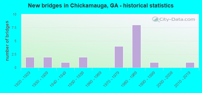
- New bridges - historical statistics
- 21920-1929
- 21930-1939
- 11940-1949
- 21950-1959
- 41970-1979
- 81980-1989
- 11990-1999
- 12010-2019

- Reconstructed bridges - Historical Statistics
- 11960-1969
- 11970-1979
- 21980-1989


- Bridge Condition - Deck
- 44.4%Good
- 38.9%Satisfactory
- 16.7%Fair

- Bridge Condition - Superstructure
- 5.6%Very good
- 55.6%Good
- 22.2%Satisfactory
- 11.1%Fair
- 5.6%Poor

- Bridge Condition - Substructure
- 66.7%Good
- 22.2%Satisfactory
- 5.6%Fair
- 5.6%Poor

- Bridge Condition - Channel
- 57.1%Very good
- 19.0%Good
- 14.3%Satisfactory
- 9.5%Fair

- Bridge Condition - Culverts
- 66.7%Good
- 33.3%Satisfactory
Find on map >> Show street view
Structure Number: 273503, Location: TERRELL-SUMTER CO LINE (Lat: 31.900839, Lng: -84.372089), Route carried "on" structure: State highway 49, Year Built: 1999, Status: Open, Structure Length: 24.08m (79.00ft), Average Daily Traffic: 460 (year 2011), Truck Traffic: 1%, Average Future Daily Traffic: 690 (year 2031), Design Load: HS 20+Mod, Features Intersected: KINCHAFOONEE CREEK
Minimum Vertical Clearance: 30+ m (98+ ft), Kilometerpoint: 6.437, Lanes on structure: 2, Base Highway Network: Yes, Owner: State Highway Agency, Approaching Roadway Width: 7.3m (24.0ft), Material/Design: Prestressed concrete, Design/Construction: Stringer/Multi-beam, Number Of Spans In Main Unit: 3, Number Of Approach Spans: 12, Length of Maximum Span: 36.6m (120.1ft), Curb-To-Curb Width: 12.1m (39.7ft), Out-to-Out Width: 12.6m (41.3ft)
Condition: Deck: Good, Superstructure: Good, Substructure: Good, Channel: Very good, Operating Rating: 58.0 metric tons, Method Used To Determine Operating Rating: Load Factor (LF), Inventory Rating: 28.1 metric tons, Method Used To Determine Inventory Rating: Load Factor (LF), Structural Evaluation: Better than present minimum criteria, Deck Geometry: Better than present minimum criteria, Waterway Adequacy: Equal to present desirable criteria, Approach Roadway Alignment: Equal to present desirable criteria, Designated Inspection Frequency: Every 24 months, Underwater Inspection Frequency: Every 60 months, Inspection Date: March 2021, Underwater Inspection Date: January 2021, Deck Structure Type: Concrete Cast-file-Place
Find on map >> Show street view
Structure Number: 2735033, Location: 2 MILES FROM HAROD (Lat: 31.703761, Lng: -84.389914), Route carried "on" structure: County highway 1662, Year Built: 2010, Status: Open, Structure Length: 7.32m (24.02ft), Average Daily Traffic: 420 (year 2011), Truck Traffic: 1%, Average Future Daily Traffic: 630 (year 2031), Design Load: HS 20+Mod, Features Intersected: CHICKASAWHATCHE CREEK, Facility Carried by Structure: SASSER-HAROD ROAD
Minimum Vertical Clearance: 30+ m (98+ ft), Kilometerpoint: 16.093, Lanes on structure: 2, Base Highway Network: Yes, Owner: County Highway Agency, Approaching Roadway Width: 7.3m (24.0ft), Material/Design: Prestressed concrete, Design/Construction: Stringer/Multi-beam, Number Of Spans In Main Unit: 4, Length of Maximum Span: 18.3m (60.0ft), Curb-To-Curb Width: 9.1m (29.9ft), Out-to-Out Width: 10.1m (33.1ft)
Condition: Deck: Good, Superstructure: Very good, Substructure: Good, Channel: Very good, Operating Rating: 75.2 metric tons, Method Used To Determine Operating Rating: Load Factor (LF), Inventory Rating: 36.2 metric tons, Method Used To Determine Inventory Rating: Load Factor (LF), Structural Evaluation: Better than present minimum criteria, Deck Geometry: Equal to present minimum criteria, Waterway Adequacy: Equal to present minimum criteria, Approach Roadway Alignment: Equal to present minimum criteria, Designated Inspection Frequency: Every 24 months, Inspection Date: March 2021, Deck Structure Type: Concrete Cast-file-Place
Find on map >> Show street view
Structure Number: 2950004, Location: 1.3 MI E OF CHICKAMAUGA (Lat: 34.873228, Lng: -85.268658), Route carried "on" structure: US 27, Year Built: 1930, Year Reconstructed: 1987, Status: Open, Structure Length: 12.53m (41.11ft), Average Daily Traffic: 14,120 (year 2011), Truck Traffic: 1%, Average Future Daily Traffic: 21,180 (year 2031), Design Load: H 15, Features Intersected: WEST CHICKAMAUGA CREEK
Minimum Vertical Clearance: 30+ m (98+ ft), Kilometerpoint: 33.796, Lanes on structure: 5, Base Highway Network: Yes, Owner: State Highway Agency, Approaching Roadway Width: 19.5m (64.0ft), Material/Design: Steel continuous, Design/Construction: Stringer/Multi-beam, Number Of Spans In Main Unit: 3, Number Of Approach Spans: 8, Length of Maximum Span: 19.8m (65.0ft), Curb-To-Curb Width: 25.0m (82.0ft), Out-to-Out Width: 26.0m (85.3ft)
Condition: Deck: Satisfactory, Superstructure: Satisfactory, Substructure: Fair, Channel: Satisfactory, Operating Rating: 34.4 metric tons, Method Used To Determine Operating Rating: Allowable Stress (AS), Inventory Rating: 20.8 metric tons, Method Used To Determine Inventory Rating: Allowable Stress (AS), Structural Evaluation: Somewhat better than minimum adequacy, Deck Geometry: Superior to present desirable criteria, Waterway Adequacy: Superior to present desirable criteria, Approach Roadway Alignment: Equal to present desirable criteria, Designated Inspection Frequency: Every 24 months, Underwater Inspection Frequency: Every 60 months, Inspection Date: December 2020, Underwater Inspection Date: July 2019, Bridge Improvement Cost: $2,920,000, Roadway Improvement Cost: $292,000, Total Project Cost: $4,380,000, Deck Structure Type: Concrete Cast-file-Place
Find on map >> Show street view
Structure Number: 2950031, Location: 4.6 MI SW OF CHICKAMAUGA (Lat: 34.811319, Lng: -85.325108), Route carried "on" structure: State highway 341, Year Built: 1974, Status: Open, Structure Length: 8.29m (27.20ft), Average Daily Traffic: 1,410 (year 2011), Truck Traffic: 1%, Average Future Daily Traffic: 2,115 (year 2031), Design Load: HS 20+Mod, Features Intersected: W CHICKAMAUGA CREEK
Minimum Vertical Clearance: 30+ m (98+ ft), Kilometerpoint: 8.047, Lanes on structure: 2, Base Highway Network: Yes, Owner: State Highway Agency, Approaching Roadway Width: 7.3m (24.0ft), Skew: 4 degrees, Material/Design: Steel, Design/Construction: Stringer/Multi-beam, Number Of Spans In Main Unit: 4, Length of Maximum Span: 20.7m (67.9ft), Curb or Sidewalk Widths: Left: 0.3m (1.0ft), Right: 0.3m (1.0ft), Curb-To-Curb Width: 10.7m (35.1ft), Out-to-Out Width: 11.9m (39.0ft)
Condition: Deck: Good, Superstructure: Good, Substructure: Good, Channel: Good, Operating Rating: 70.7 metric tons, Method Used To Determine Operating Rating: Load Factor (LF), Inventory Rating: 42.6 metric tons, Method Used To Determine Inventory Rating: Load Factor (LF), Structural Evaluation: Better than present minimum criteria, Deck Geometry: Equal to present minimum criteria, Waterway Adequacy: Equal to present desirable criteria, Approach Roadway Alignment: Equal to present desirable criteria, Designated Inspection Frequency: Every 24 months, Underwater Inspection Frequency: Every 60 months, Inspection Date: December 2020, Underwater Inspection Date: July 2019, Bridge Improvement Cost: $1,063,000, Roadway Improvement Cost: $106,000, Total Project Cost: $1,594,000, Deck Structure Type: Concrete Cast-file-Place
Find on map >> Show street view
Structure Number: 2950032, Location: IN NORTH CHICKAMAUGA (Lat: 34.878478, Lng: -85.292678), Route carried "on" structure: State highway 341, Year Built: 1982, Status: Open, Structure Length: 1.37m (4.49ft), Average Daily Traffic: 4,290 (year 2011), Truck Traffic: 3%, Average Future Daily Traffic: 6,435 (year 2031), Design Load: HS 20+Mod, Features Intersected: W CHICKAMAUGA CRK TRIB.
Minimum Vertical Clearance: 30+ m (98+ ft), Kilometerpoint: 16.093, Lanes on structure: 2, Base Highway Network: Yes, Owner: State Highway Agency, Approaching Roadway Width: 6.4m (21.0ft), Skew: 4 degrees, Material/Design: Concrete, Design/Construction: Culvert, Number Of Spans In Main Unit: 3, Length of Maximum Span: 4.3m (14.1ft)
Condition: Channel: Very good, Culverts: Good, Operating Rating: 59.8 metric tons, Method Used To Determine Operating Rating: Load Factor (LF), Inventory Rating: 36.2 metric tons, Method Used To Determine Inventory Rating: Load Factor (LF), Structural Evaluation: Better than present minimum criteria, Waterway Adequacy: Superior to present desirable criteria, Approach Roadway Alignment: Equal to present desirable criteria, Designated Inspection Frequency: Every 24 months, Inspection Date: December 2020, Bridge Improvement Cost: $176,000, Roadway Improvement Cost: $18,000, Total Project Cost: $264,000
Find on map >> Show street view
Structure Number: 295005, Location: 2 MI W OF FT OGLETHORPE (Lat: 34.950928, Lng: -85.308147), Route carried "on" structure: State highway 2, Year Built: 1985, Status: Open, Structure Length: 0.94m (3.08ft), Average Daily Traffic: 13,220 (year 2011), Truck Traffic: 1%, Average Future Daily Traffic: 19,830 (year 2031), Design Load: HS 20+Mod, Features Intersected: DRY CREEK
Minimum Vertical Clearance: 30+ m (98+ ft), Kilometerpoint: 3.219, Lanes on structure: 4, Base Highway Network: Yes, Owner: State Highway Agency, Approaching Roadway Width: 21.3m (69.9ft), Skew: 2 degrees, Material/Design: Concrete, Design/Construction: Culvert, Number Of Spans In Main Unit: 3, Length of Maximum Span: 3.0m (9.8ft)
Condition: Channel: Good, Culverts: Satisfactory, Operating Rating: 38.1 metric tons, Method Used To Determine Operating Rating: Load Factor (LF), Inventory Rating: 22.6 metric tons, Method Used To Determine Inventory Rating: Load Factor (LF), Structural Evaluation: Somewhat better than minimum adequacy, Waterway Adequacy: Superior to present desirable criteria, Approach Roadway Alignment: Equal to present desirable criteria, Designated Inspection Frequency: Every 24 months, Inspection Date: Febuary 2021, Bridge Improvement Cost: $187,000, Roadway Improvement Cost: $19,000, Total Project Cost: $281,000
Find on map >> Show street view
Structure Number: 2950057, Location: IN EAST CHICKAMAUGA (Lat: 34.875289, Lng: -85.285219), Route carried "on" structure: City street 1106, Year Built: 1987, Status: Open, Structure Length: 0.64m (2.10ft), Average Daily Traffic: 4,980 (year 2011), Truck Traffic: 1%, Average Future Daily Traffic: 7,470 (year 2031), Design Load: HS 20+Mod, Features Intersected: W CHICKAMAUGA CRK TRIB, Facility Carried by Structure: CRITTENDEN STREET
Minimum Vertical Clearance: 30+ m (98+ ft), Kilometerpoint: 1.609, Lanes on structure: 2, Base Highway Network: Yes, Owner: City or Municipal Highway Agency, Approaching Roadway Width: 6.4m (21.0ft), Material/Design: Concrete, Design/Construction: Culvert, Number Of Spans In Main Unit: 2, Length of Maximum Span: 3.0m (9.8ft), Curb-To-Curb Width: 15.9m (52.2ft), Out-to-Out Width: 16.8m (55.1ft)
Condition: Channel: Very good, Culverts: Good, Operating Rating: 55.3 metric tons, Method Used To Determine Operating Rating: Field evaluation and documented engineering judgment, Inventory Rating: 32.6 metric tons, Method Used To Determine Inventory Rating: Field evaluation and documented engineering judgment, Structural Evaluation: Better than present minimum criteria, Deck Geometry: Superior to present desirable criteria, Waterway Adequacy: Superior to present desirable criteria, Approach Roadway Alignment: Equal to present desirable criteria, Designated Inspection Frequency: Every 24 months, Inspection Date: December 2020, Bridge Improvement Cost: $82,000, Roadway Improvement Cost: $8,000, Total Project Cost: $123,000
Find on map >> Show street view
Structure Number: 2955034, Location: 8.9 MI N OF LAFAYETTE (Lat: 34.824328, Lng: -85.250508), Route carried "on" structure: County highway 119, Year Built: 1923, Year Reconstructed: 1976, Status: Posted for load, Structure Length: 1.04m (3.41ft), Average Daily Traffic: 790 (year 2011), Truck Traffic: 1%, Average Future Daily Traffic: 1,185 (year 2031), Features Intersected: CRAWFISH CREEK, Facility Carried by Structure: STRAIGHT CUT ROAD
Minimum Vertical Clearance: 30+ m (98+ ft), Kilometerpoint: 0.000, Lanes on structure: 2, Base Highway Network: Yes, Owner: County Highway Agency, Approaching Roadway Width: 5.5m (18.0ft), Material/Design: Steel continuous, Design/Construction: Stringer/Multi-beam, Number Of Spans In Main Unit: 2, Length of Maximum Span: 5.2m (17.1ft), Curb or Sidewalk Widths: Left: 0.2m (0.7ft), Right: 0.2m (0.7ft), Curb-To-Curb Width: 6.4m (21.0ft), Out-to-Out Width: 6.7m (22.0ft)
Condition: Deck: Fair, Superstructure: Poor, Substructure: Poor, Channel: Very good, Operating Rating: 8.1 metric tons, Method Used To Determine Operating Rating: Field evaluation and documented engineering judgment, Inventory Rating: 4.5 metric tons, Method Used To Determine Inventory Rating: Field evaluation and documented engineering judgment, Structural Evaluation: High priority of replacement, Deck Geometry: High priority of corrective action, Waterway Adequacy: Equal to present desirable criteria, Approach Roadway Alignment: Equal to present desirable criteria, Bridge Posting: Required (Relationship of Operating Rating to Maximum Legal Load: > 39.9% below), Length Of Structure Improvement: 7.47m (24.51ft), Designated Inspection Frequency: Every 24 months, Inspection Date: November 2020, Bridge Improvement Cost: $133,000, Roadway Improvement Cost: $13,000, Total Project Cost: $199,000, Deck Structure Type: Concrete Cast-file-Place, Wearing Surface/Protective System: Wearing Surface: Bituminous
Find on map >> Show street view
Structure Number: 295504, Location: 3.7 MI SE OF CHICKAMAUGA (Lat: 34.831800, Lng: -85.249369), Route carried "on" structure: County highway 164, Year Built: 1948, Status: Posted for load, Structure Length: 0.82m (2.69ft), Average Daily Traffic: 260 (year 2011), Truck Traffic: 1%, Average Future Daily Traffic: 390 (year 2031), Features Intersected: CRAWFISH CREEK, Facility Carried by Structure: GOODSON CIRCLE
Minimum Vertical Clearance: 30+ m (98+ ft), Kilometerpoint: 0.000, Lanes on structure: 2, Base Highway Network: Yes, Owner: County Highway Agency, Approaching Roadway Width: 5.2m (17.1ft), Material/Design: Concrete, Design/Construction: Slab, Number Of Spans In Main Unit: 1, Length of Maximum Span: 8.2m (26.9ft), Curb or Sidewalk Widths: Left: 0.2m (0.7ft), Right: 0.2m (0.7ft), Curb-To-Curb Width: 6.2m (20.3ft), Out-to-Out Width: 6.6m (21.7ft)
Condition: Deck: Fair, Superstructure: Fair, Substructure: Satisfactory, Channel: Good, Operating Rating: 31.7 metric tons, Method Used To Determine Operating Rating: Allowable Stress (AS), Inventory Rating: 15.4 metric tons, Method Used To Determine Inventory Rating: Allowable Stress (AS), Structural Evaluation: Meets minimum limits, Deck Geometry: Meets minimum limits, Waterway Adequacy: Superior to present desirable criteria, Approach Roadway Alignment: Equal to present desirable criteria, Bridge Posting: Required (Relationship of Operating Rating to Maximum Legal Load: 10.0 - 19.9% below), Length Of Structure Improvement: 7.25m (23.79ft), Designated Inspection Frequency: Every 24 months, Inspection Date: November 2020, Bridge Improvement Cost: $105,000, Roadway Improvement Cost: $11,000, Total Project Cost: $158,000, Deck Structure Type: Concrete Cast-file-Place, Wearing Surface/Protective System: Wearing Surface: Bituminous
Find on map >> Show street view
Structure Number: 2955041, Location: 1.6 MI SE OF CHICKAMAUGA (Lat: 34.853339, Lng: -85.273769), Route carried "on" structure: County highway 166, Year Built: 1958, Status: Posted for load, Structure Length: 4.63m (15.19ft), Average Daily Traffic: 530 (year 2011), Truck Traffic: 1%, Average Future Daily Traffic: 795 (year 2031), Design Load: H 15, Features Intersected: WEST CHICKAMAUGA CREEK, Facility Carried by Structure: GLASS MILL ROAD
Minimum Vertical Clearance: 30+ m (98+ ft), Kilometerpoint: 3.219, Lanes on structure: 2, Base Highway Network: Yes, Owner: County Highway Agency, Approaching Roadway Width: 6.1m (20.0ft), Material/Design: Concrete, Design/Construction: Tee Beam, Number Of Spans In Main Unit: 4, Length of Maximum Span: 11.6m (38.1ft), Curb or Sidewalk Widths: Left: 0.6m (2.0ft), Right: 0.6m (2.0ft), Curb-To-Curb Width: 7.9m (25.9ft), Out-to-Out Width: 9.8m (32.2ft)
Condition: Deck: Good, Superstructure: Good, Substructure: Good, Channel: Very good, Operating Rating: 21.7 metric tons, Method Used To Determine Operating Rating: Load Factor (LF), Inventory Rating: 12.7 metric tons, Method Used To Determine Inventory Rating: Load Factor (LF), Structural Evaluation: Meets minimum limits, Deck Geometry: Somewhat better than minimum adequacy, Waterway Adequacy: Superior to present desirable criteria, Approach Roadway Alignment: Better than present minimum criteria, Bridge Posting: Required (Relationship of Operating Rating to Maximum Legal Load: 30.0 - 39.9% below), Length Of Structure Improvement: 11.06m (36.29ft), Designated Inspection Frequency: Every 24 months, Inspection Date: December 2020, Bridge Improvement Cost: $594,000, Roadway Improvement Cost: $59,000, Total Project Cost: $891,000, Deck Structure Type: Concrete Cast-file-Place
Find on map >> Show street view
Structure Number: 2955042, Location: 2.3 MI SE OF CHICKAMAUGA (Lat: 34.847669, Lng: -85.263489), Route carried "on" structure: County highway 166, Year Built: 1974, Status: Open, Structure Length: 2.07m (6.79ft), Average Daily Traffic: 1,010 (year 2011), Truck Traffic: 1%, Average Future Daily Traffic: 1,515 (year 2031), Features Intersected: CRAWFISH CREEK, Facility Carried by Structure: GLASS MILL ROAD
Minimum Vertical Clearance: 30+ m (98+ ft), Kilometerpoint: 4.828, Lanes on structure: 2, Base Highway Network: Yes, Owner: County Highway Agency, Approaching Roadway Width: 6.1m (20.0ft), Skew: 5 degrees, Material/Design: Concrete, Design/Construction: Tee Beam, Number Of Spans In Main Unit: 3, Length of Maximum Span: 7.0m (23.0ft), Curb or Sidewalk Widths: Left: 0.3m (1.0ft), Right: 0.3m (1.0ft), Curb-To-Curb Width: 7.3m (24.0ft), Out-to-Out Width: 8.5m (27.9ft)
Condition: Deck: Satisfactory, Superstructure: Good, Substructure: Good, Channel: Very good, Operating Rating: 39.0 metric tons, Method Used To Determine Operating Rating: Load Factor (LF), Inventory Rating: 15.4 metric tons, Method Used To Determine Inventory Rating: Load Factor (LF), Structural Evaluation: Meets minimum limits, Deck Geometry: Meets minimum limits, Waterway Adequacy: Superior to present desirable criteria, Approach Roadway Alignment: Equal to present desirable criteria, Length Of Structure Improvement: 8.56m (28.08ft), Designated Inspection Frequency: Every 24 months, Inspection Date: December 2020, Bridge Improvement Cost: $266,000, Roadway Improvement Cost: $27,000, Total Project Cost: $399,000, Deck Structure Type: Concrete Cast-file-Place
Find on map >> Show street view
Structure Number: 2955043, Location: 2 MI S OF CHICKAMAUGA (Lat: 34.850739, Lng: -85.286628), Route carried "on" structure: County highway 168, Year Built: 1980, Status: Posted for load, Structure Length: 6.10m (20.01ft), Average Daily Traffic: 430 (year 2011), Truck Traffic: 1%, Average Future Daily Traffic: 645 (year 2031), Features Intersected: WEST CHICKAMAUGA CREEK, Facility Carried by Structure: LOFTON LANE
Minimum Vertical Clearance: 30+ m (98+ ft), Kilometerpoint: 0.000, Lanes on structure: 2, Base Highway Network: Yes, Owner: County Highway Agency, Approaching Roadway Width: 6.1m (20.0ft), Skew: 1 degrees, Material/Design: Steel, Design/Construction: Stringer/Multi-beam, Number Of Spans In Main Unit: 7, Length of Maximum Span: 12.2m (40.0ft), Curb-To-Curb Width: 7.6m (24.9ft), Out-to-Out Width: 8.3m (27.2ft)
Condition: Deck: Satisfactory, Superstructure: Satisfactory, Substructure: Good, Channel: Fair, Operating Rating: 22.6 metric tons, Method Used To Determine Operating Rating: Load Factor (LF), Inventory Rating: 13.6 metric tons, Method Used To Determine Inventory Rating: Load Factor (LF), Structural Evaluation: Meets minimum limits, Deck Geometry: Meets minimum limits, Waterway Adequacy: Better than present minimum criteria, Approach Roadway Alignment: Equal to present desirable criteria, Bridge Posting: Required (Relationship of Operating Rating to Maximum Legal Load: 30.0 - 39.9% below), Length Of Structure Improvement: 12.53m (41.11ft), Designated Inspection Frequency: Every 24 months, Underwater Inspection Frequency: Every 60 months, Inspection Date: December 2020, Underwater Inspection Date: July 2019, Bridge Improvement Cost: $781,000, Roadway Improvement Cost: $78,000, Total Project Cost: $1,172,000, Deck Structure Type: Concrete Cast-file-Place
Find on map >> Show street view
Structure Number: 2955044, Location: 3 MI SW OF CHICKAMAUGA (Lat: 34.833078, Lng: -85.316500), Route carried "on" structure: County highway 169, Year Built: 1958, Status: Posted for load, Structure Length: 4.15m (13.62ft), Average Daily Traffic: 470 (year 2011), Truck Traffic: 1%, Average Future Daily Traffic: 705 (year 2031), Design Load: H 15, Features Intersected: WEST CHICKAMAUGA CREEK, Facility Carried by Structure: OLD BETHEL ROAD
Minimum Vertical Clearance: 30+ m (98+ ft), Kilometerpoint: 0.000, Lanes on structure: 2, Base Highway Network: Yes, Owner: County Highway Agency, Approaching Roadway Width: 6.4m (21.0ft), Material/Design: Concrete, Design/Construction: Tee Beam, Number Of Spans In Main Unit: 4, Length of Maximum Span: 10.4m (34.1ft), Curb or Sidewalk Widths: Left: 0.6m (2.0ft), Right: 0.6m (2.0ft), Curb-To-Curb Width: 7.9m (25.9ft), Out-to-Out Width: 9.8m (32.2ft)
Condition: Deck: Good, Superstructure: Good, Substructure: Satisfactory, Channel: Fair, Operating Rating: 23.5 metric tons, Method Used To Determine Operating Rating: Load Factor (LF), Inventory Rating: 14.5 metric tons, Method Used To Determine Inventory Rating: Load Factor (LF), Structural Evaluation: Meets minimum limits, Deck Geometry: Somewhat better than minimum adequacy, Waterway Adequacy: Better than present minimum criteria, Approach Roadway Alignment: Equal to present desirable criteria, Bridge Posting: Required (Relationship of Operating Rating to Maximum Legal Load: 20.0 - 29.9% below), Designated Inspection Frequency: Every 24 months, Inspection Date: December 2020, Bridge Improvement Cost: $531,000, Roadway Improvement Cost: $53,000, Total Project Cost: $797,000, Deck Structure Type: Concrete Cast-file-Place
Find on map >> Show street view
Structure Number: 2955045, Location: 4 MI SW OF CHICKAMAUGA (Lat: 34.824208, Lng: -85.317219), Route carried "on" structure: County highway 172, Year Built: 1980, Status: Posted for load, Structure Length: 3.05m (10.01ft), Average Daily Traffic: 330 (year 2011), Truck Traffic: 1%, Average Future Daily Traffic: 495 (year 2031), Features Intersected: WEST CHICKAMAUGA CREEK, Facility Carried by Structure: BAKER-HEARN CIRCLE
Minimum Vertical Clearance: 30+ m (98+ ft), Kilometerpoint: 0.000, Lanes on structure: 2, Base Highway Network: Yes, Owner: County Highway Agency, Approaching Roadway Width: 5.5m (18.0ft), Skew: 1 degrees, Material/Design: Steel, Design/Construction: Stringer/Multi-beam, Number Of Spans In Main Unit: 3, Length of Maximum Span: 11.6m (38.1ft), Curb-To-Curb Width: 7.4m (24.3ft), Out-to-Out Width: 8.6m (28.2ft)
Condition: Deck: Satisfactory, Superstructure: Good, Substructure: Good, Channel: Very good, Operating Rating: 29.9 metric tons, Method Used To Determine Operating Rating: Load Factor (LF), Inventory Rating: 17.2 metric tons, Method Used To Determine Inventory Rating: Load Factor (LF), Structural Evaluation: Somewhat better than minimum adequacy, Deck Geometry: Somewhat better than minimum adequacy, Waterway Adequacy: Superior to present desirable criteria, Approach Roadway Alignment: Equal to present desirable criteria, Bridge Posting: Required (Relationship of Operating Rating to Maximum Legal Load: 10.0 - 19.9% below), Designated Inspection Frequency: Every 24 months, Inspection Date: December 2020, Bridge Improvement Cost: $391,000, Roadway Improvement Cost: $39,000, Total Project Cost: $586,000, Deck Structure Type: Concrete Cast-file-Place
Find on map >> Show street view
Structure Number: 2955046, Location: 4 MI SW OF CHICKAMAUGA (Lat: 34.822089, Lng: -85.315939), Route carried "on" structure: County highway 172, Year Built: 1978, Status: Open, Structure Length: 1.22m (4.00ft), Average Daily Traffic: 330 (year 2011), Truck Traffic: 1%, Average Future Daily Traffic: 495 (year 2031), Features Intersected: W CHICKAMAUGA CRK O/F, Facility Carried by Structure: BAKER-HEARN CIRCLE
Minimum Vertical Clearance: 30+ m (98+ ft), Kilometerpoint: 1.609, Lanes on structure: 2, Base Highway Network: Yes, Owner: County Highway Agency, Approaching Roadway Width: 5.5m (18.0ft), Skew: 1 degrees, Material/Design: Steel continuous, Design/Construction: Stringer/Multi-beam, Number Of Spans In Main Unit: 2, Length of Maximum Span: 6.4m (21.0ft), Curb or Sidewalk Widths: Left: 0.2m (0.7ft), Right: 0.2m (0.7ft), Curb-To-Curb Width: 7.3m (24.0ft), Out-to-Out Width: 8.5m (27.9ft)
Condition: Deck: Satisfactory, Superstructure: Good, Substructure: Good, Channel: Very good, Operating Rating: 86.1 metric tons, Method Used To Determine Operating Rating: Load Factor (LF), Inventory Rating: 51.7 metric tons, Method Used To Determine Inventory Rating: Load Factor (LF), Structural Evaluation: Better than present minimum criteria, Deck Geometry: Somewhat better than minimum adequacy, Waterway Adequacy: Equal to present desirable criteria, Approach Roadway Alignment: Better than present minimum criteria, Designated Inspection Frequency: Every 24 months, Inspection Date: December 2020, Bridge Improvement Cost: $156,000, Roadway Improvement Cost: $16,000, Total Project Cost: $234,000, Deck Structure Type: Concrete Cast-file-Place
Find on map >> Show street view
Structure Number: 2955047, Location: 3.9 MI S OF CHICKAMAUGA (Lat: 34.817758, Lng: -85.306989), Route carried "on" structure: County highway 173, Year Built: 1935, Year Reconstructed: 1980, Status: Open, Structure Length: 0.82m (2.69ft), Average Daily Traffic: 100 (year 2011), Truck Traffic: 1%, Average Future Daily Traffic: 150 (year 2031), Features Intersected: W CHICKAMAUGA CRK TRIB, Facility Carried by Structure: BROCK ROAD
Minimum Vertical Clearance: 30+ m (98+ ft), Kilometerpoint: 1.609, Lanes on structure: 2, Base Highway Network: Yes, Owner: County Highway Agency, Approaching Roadway Width: 4.9m (16.1ft), Material/Design: Concrete continuous, Design/Construction: Tee Beam, Number Of Spans In Main Unit: 2, Length of Maximum Span: 4.3m (14.1ft), Curb or Sidewalk Widths: Left: 0.2m (0.7ft), Right: 0.2m (0.7ft), Curb-To-Curb Width: 7.5m (24.6ft), Out-to-Out Width: 8.7m (28.5ft)
Condition: Deck: Good, Superstructure: Satisfactory, Substructure: Good, Channel: Very good, Operating Rating: 33.5 metric tons, Method Used To Determine Operating Rating: Allowable Stress (AS), Inventory Rating: 24.4 metric tons, Method Used To Determine Inventory Rating: Allowable Stress (AS), Structural Evaluation: Equal to present minimum criteria, Deck Geometry: Equal to present minimum criteria, Waterway Adequacy: Equal to present desirable criteria, Approach Roadway Alignment: Better than present minimum criteria, Designated Inspection Frequency: Every 24 months, Inspection Date: December 2020, Bridge Improvement Cost: $105,000, Roadway Improvement Cost: $11,000, Total Project Cost: $158,000, Deck Structure Type: Concrete Cast-file-Place
Find on map >> Show street view
Structure Number: 295505, Location: 4.8 MI SW OF CHICKAMAUGA (Lat: 34.818758, Lng: -85.346439), Route carried "on" structure: County highway 183, Year Built: 1925, Year Reconstructed: 1974, Status: Open, Structure Length: 0.91m (2.99ft), Average Daily Traffic: 400 (year 2011), Truck Traffic: 1%, Average Future Daily Traffic: 600 (year 2031), Features Intersected: W CHICKAMAUGA CRK TRIB, Facility Carried by Structure: BOSS ROAD
Minimum Vertical Clearance: 30+ m (98+ ft), Kilometerpoint: 0.000, Lanes on structure: 2, Base Highway Network: Yes, Owner: County Highway Agency, Approaching Roadway Width: 5.5m (18.0ft), Skew: 5 degrees, Material/Design: Steel continuous, Design/Construction: Stringer/Multi-beam, Number Of Spans In Main Unit: 2, Length of Maximum Span: 4.6m (15.1ft), Curb or Sidewalk Widths: Left: 0.2m (0.7ft), Right: 0.2m (0.7ft), Curb-To-Curb Width: 5.3m (17.4ft), Out-to-Out Width: 5.6m (18.4ft)
Condition: Deck: Satisfactory, Superstructure: Fair, Substructure: Satisfactory, Channel: Satisfactory, Operating Rating: 44.4 metric tons, Method Used To Determine Operating Rating: Load Factor (LF), Inventory Rating: 26.3 metric tons, Method Used To Determine Inventory Rating: Load Factor (LF), Structural Evaluation: Somewhat better than minimum adequacy, Deck Geometry: High priority of replacement, Waterway Adequacy: Better than present minimum criteria, Approach Roadway Alignment: Meets minimum limits, Designated Inspection Frequency: Every 24 months, Inspection Date: December 2020, Bridge Improvement Cost: $117,000, Roadway Improvement Cost: $12,000, Total Project Cost: $176,000, Deck Structure Type: Concrete Cast-file-Place, Wearing Surface/Protective System: Wearing Surface: Bituminous
Find on map >> Show street view
Structure Number: 2955053, Location: 3.8 MI SW OF CHICKAMAUGA (Lat: 34.838589, Lng: -85.344958), Route carried "on" structure: County highway 195, Year Built: 1988, Status: Open, Structure Length: 0.85m (2.79ft), Average Daily Traffic: 100 (year 2011), Truck Traffic: 1%, Average Future Daily Traffic: 150 (year 2031), Features Intersected: BROTHERTON CREEK, Facility Carried by Structure: BOSS ROAD
Minimum Vertical Clearance: 30+ m (98+ ft), Kilometerpoint: 0.000, Lanes on structure: 2, Base Highway Network: Yes, Owner: County Highway Agency, Approaching Roadway Width: 5.5m (18.0ft), Skew: 4 degrees, Material/Design: Steel continuous, Design/Construction: Stringer/Multi-beam, Number Of Spans In Main Unit: 2, Length of Maximum Span: 4.3m (14.1ft), Curb-To-Curb Width: 7.3m (24.0ft), Out-to-Out Width: 8.2m (26.9ft)
Condition: Deck: Good, Superstructure: Good, Substructure: Good, Channel: Good, Operating Rating: 62.5 metric tons, Method Used To Determine Operating Rating: Load Factor (LF), Inventory Rating: 37.1 metric tons, Method Used To Determine Inventory Rating: Load Factor (LF), Structural Evaluation: Better than present minimum criteria, Deck Geometry: Equal to present minimum criteria, Waterway Adequacy: Superior to present desirable criteria, Approach Roadway Alignment: Equal to present desirable criteria, Designated Inspection Frequency: Every 24 months, Inspection Date: December 2020, Bridge Improvement Cost: $109,000, Roadway Improvement Cost: $11,000, Total Project Cost: $164,000, Deck Structure Type: Concrete Cast-file-Place, Wearing Surface/Protective System: Wearing Surface: Bituminous
Find on map >> Show street view
Structure Number: 2955054, Location: 4.1 MI SW OF CHICKAMAUGA (Lat: 34.824089, Lng: -85.333069), Route carried "on" structure: County highway 196, Year Built: 1977, Status: Open, Structure Length: 0.91m (2.99ft), Average Daily Traffic: 350 (year 2011), Truck Traffic: 1%, Average Future Daily Traffic: 525 (year 2031), Features Intersected: BROTHERTON CREEK, Facility Carried by Structure: BROTHERTON ROAD
Minimum Vertical Clearance: 30+ m (98+ ft), Kilometerpoint: 0.000, Lanes on structure: 2, Base Highway Network: Yes, Owner: County Highway Agency, Approaching Roadway Width: 5.5m (18.0ft), Skew: 3 degrees, Material/Design: Steel, Design/Construction: Stringer/Multi-beam, Number Of Spans In Main Unit: 1, Length of Maximum Span: 9.1m (29.9ft), Curb or Sidewalk Widths: Left: 0.3m (1.0ft), Right: 0.3m (1.0ft), Curb-To-Curb Width: 7.3m (24.0ft), Out-to-Out Width: 8.5m (27.9ft)
Condition: Deck: Fair, Superstructure: Satisfactory, Substructure: Satisfactory, Channel: Very good, Operating Rating: 36.2 metric tons, Method Used To Determine Operating Rating: Load Factor (LF), Inventory Rating: 21.7 metric tons, Method Used To Determine Inventory Rating: Load Factor (LF), Structural Evaluation: Equal to present minimum criteria, Deck Geometry: Somewhat better than minimum adequacy, Waterway Adequacy: Superior to present desirable criteria, Approach Roadway Alignment: Better than present minimum criteria, Designated Inspection Frequency: Every 24 months, Inspection Date: December 2020, Bridge Improvement Cost: $117,000, Roadway Improvement Cost: $12,000, Total Project Cost: $176,000, Deck Structure Type: Concrete Cast-file-Place
Find on map >> Show street view
Structure Number: 2955055, Location: 1.6 MI NE OF CHICKAMAUGA (Lat: 34.882308, Lng: -85.267308), Route carried "on" structure: County highway 219, Year Built: 1980, Status: Posted for load, Structure Length: 3.96m (12.99ft), Average Daily Traffic: 2,580 (year 2011), Truck Traffic: 1%, Average Future Daily Traffic: 3,870 (year 2031), Features Intersected: WEST CHICKAMAUGA CREEK, Facility Carried by Structure: RED BELT ROAD
Minimum Vertical Clearance: 30+ m (98+ ft), Kilometerpoint: 0.000, Lanes on structure: 2, Base Highway Network: Yes, Owner: County Highway Agency, Approaching Roadway Width: 6.4m (21.0ft), Material/Design: Steel, Design/Construction: Stringer/Multi-beam, Number Of Spans In Main Unit: 4, Length of Maximum Span: 12.2m (40.0ft), Curb-To-Curb Width: 7.5m (24.6ft), Out-to-Out Width: 8.5m (27.9ft)
Condition: Deck: Satisfactory, Superstructure: Good, Substructure: Good, Channel: Satisfactory, Operating Rating: 18.1 metric tons, Method Used To Determine Operating Rating: Load Factor (LF), Inventory Rating: 10.8 metric tons, Method Used To Determine Inventory Rating: Load Factor (LF), Structural Evaluation: High priority of replacement, Deck Geometry: High priority of replacement, Waterway Adequacy: Equal to present desirable criteria, Approach Roadway Alignment: Equal to present minimum criteria, Bridge Posting: Required (Relationship of Operating Rating to Maximum Legal Load: > 39.9% below), Length Of Structure Improvement: 44.20m (145.01ft), Designated Inspection Frequency: Every 24 months, Underwater Inspection Frequency: Every 60 months, Inspection Date: December 2020, Underwater Inspection Date: July 2019, Bridge Improvement Cost: $508,000, Roadway Improvement Cost: $51,000, Total Project Cost: $762,000, Deck Structure Type: Concrete Cast-file-Place
Find on map >> Show street view
Structure Number: 2955073, Location: 2 MI SW OF CHICKAMAUGA (Lat: 34.845269, Lng: -85.305778), Route carried "on" structure: County highway 171, Year Built: 1984, Status: Open, Structure Length: 4.05m (13.29ft), Average Daily Traffic: 140 (year 2011), Truck Traffic: 1%, Average Future Daily Traffic: 210 (year 2031), Features Intersected: W. CHICKAMAUGA CREEK, Facility Carried by Structure: MARTIN CLEMENT RD.
Minimum Vertical Clearance: 30+ m (98+ ft), Kilometerpoint: 1.609, Lanes on structure: 2, Base Highway Network: Yes, Owner: County Highway Agency, Approaching Roadway Width: 5.5m (18.0ft), Skew: 1 degrees, Material/Design: Steel, Design/Construction: Stringer/Multi-beam, Number Of Spans In Main Unit: 2, Length of Maximum Span: 21.6m (70.9ft), Curb-To-Curb Width: 7.7m (25.3ft), Out-to-Out Width: 8.8m (28.9ft)
Condition: Deck: Good, Superstructure: Good, Substructure: Good, Channel: Very good, Operating Rating: 64.4 metric tons, Method Used To Determine Operating Rating: Load Factor (LF), Inventory Rating: 38.1 metric tons, Method Used To Determine Inventory Rating: Load Factor (LF), Structural Evaluation: Better than present minimum criteria, Deck Geometry: Somewhat better than minimum adequacy, Waterway Adequacy: Equal to present desirable criteria, Approach Roadway Alignment: Equal to present minimum criteria, Designated Inspection Frequency: Every 24 months, Inspection Date: December 2020, Bridge Improvement Cost: $520,000, Roadway Improvement Cost: $52,000, Total Project Cost: $779,000, Deck Structure Type: Concrete Cast-file-Place