Bridge Statistics for Chinchilla, Pennsylvania (PA)
Condition, Traffic, Stress, Structural Evaluation, Project Costs
- National Bridge Inventory (NBI) Statistics
- 48Number of bridges
- 249ft / 76.2mTotal length
- $4,398,000Total costs
- 439,099Total average daily traffic
- 87,887Total average daily truck traffic
- National Bridge Inventory (NBI) Registered Bridges for Chinchilla
- No street view available for this location
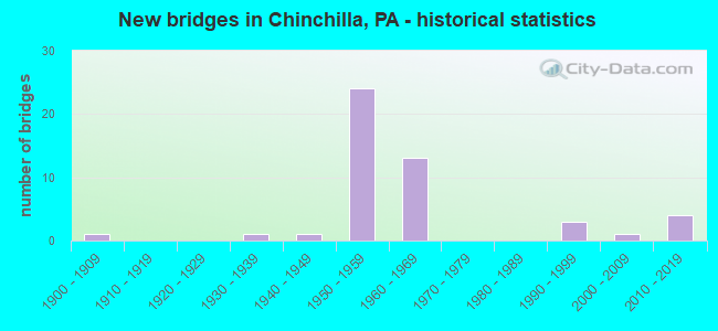
- New bridges - historical statistics
- 11900-1909
- 11930-1939
- 11940-1949
- 241950-1959
- 131960-1969
- 31990-1999
- 12000-2009
- 42010-2019

- Reconstructed bridges - Historical Statistics
- 11970-1979
- 21980-1989
- 01990-1999
- 62000-2009
- 12010-2019
- 42020-2022


- Bridge Condition - Deck
- 20.0%Very good
- 40.0%Good
- 20.0%Satisfactory
- 15.0%Fair
- 5.0%Poor

- Bridge Condition - Superstructure
- 5.0%Excellent
- 10.0%Very good
- 45.0%Good
- 15.0%Satisfactory
- 15.0%Fair
- 10.0%Poor

- Bridge Condition - Substructure
- 10.0%Very good
- 20.0%Good
- 55.0%Satisfactory
- 15.0%Fair

- Bridge Condition - Channel
- 16.7%Very good
- 16.7%Satisfactory
- 33.3%Fair
- 33.3%Poor
Find on map >> Show street view
Structure Number: 20378, Location: S ABNGTON TWP JCT SR 4032 (Lat: 41.475069, Lng: -75.683125), Route carried "on" structure: US 11, Year Built: 1936, Status: Open, Structure Length: 1.10m (3.61ft), Average Daily Traffic: 22,355 (year 2022), Truck Traffic: 3%, Average Future Daily Traffic: 30,334 (year 2032), Design Load: H 20, Features Intersected: SUMMIT LAKE CREEK
Minimum Vertical Clearance: 30+ m (98+ ft), Kilometerpoint: 18.533, Lanes on structure: 3, Base Highway Network: Yes, Owner: State Highway Agency, Approaching Roadway Width: 18.9m (62.0ft), Skew: 1 degrees, Material/Design: Concrete, Design/Construction: Tee Beam, Number Of Spans In Main Unit: 1, Length of Maximum Span: 10.4m (34.1ft), Curb or Sidewalk Widths: Left: 1.3m (4.3ft), Right: 0.2m (0.7ft), Curb-To-Curb Width: 18.8m (61.7ft), Out-to-Out Width: 20.7m (67.9ft)
Condition: Deck: Satisfactory, Superstructure: Fair, Substructure: Fair, Channel: Poor, Operating Rating: 51.7 metric tons, Method Used To Determine Operating Rating: Load Factor (LF), Inventory Rating: 30.8 metric tons, Method Used To Determine Inventory Rating: Load Factor (LF), Structural Evaluation: Somewhat better than minimum adequacy, Deck Geometry: Superior to present desirable criteria, Waterway Adequacy: Equal to present minimum criteria, Approach Roadway Alignment: Equal to present desirable criteria, Length Of Structure Improvement: 1.10m (3.61ft), Designated Inspection Frequency: Every 24 months, Inspection Date: July 2020, Bridge Improvement Cost: $18,000, Roadway Improvement Cost: $100,000, Total Project Cost: $243,000, Deck Structure Type: Concrete Cast-file-Place, Wearing Surface/Protective System: Wearing Surface: Bituminous
Find on map >> Show street view
Structure Number: 20462, Location: S ABINGTON OVR TWP RD 444 (Lat: 41.469311, Lng: -75.670558), Route carried "on" structure: Interstate 81, Year Built: 1961, Year Reconstructed: 2020, Status: Open, Structure Length: 5.12m (16.80ft), Average Daily Traffic: 18,992 (year 2021), Truck Traffic: 20%, Average Future Daily Traffic: 20,367 (year 2032), Design Load: HS 20+Mod, Features Intersected: TWP RD 444 SCOTT ROAD
Minimum Vertical Clearance: 30+ m (98+ ft), Kilometerpoint: 21.256, Lanes on structure: 2, Lanes under structure: 2, Base Highway Network: Yes, Owner: State Highway Agency, Approaching Roadway Width: 11.9m (39.0ft), Skew: 15 degrees, Material/Design: Prestressed concrete, Design/Construction: Stringer/Multi-beam, Number Of Spans In Main Unit: 3, Length of Maximum Span: 18.3m (60.0ft), Curb or Sidewalk Widths: Left: 0.2m (0.7ft), Right: 0.2m (0.7ft), Curb-To-Curb Width: 12.9m (42.3ft), Out-to-Out Width: 13.9m (45.6ft)
Condition: Deck: Good, Superstructure: Good, Substructure: Satisfactory, Operating Rating: 83.5 metric tons, Method Used To Determine Operating Rating: Load Factor (LF), Inventory Rating: 29.0 metric tons, Method Used To Determine Inventory Rating: Load Factor (LF), Structural Evaluation: Equal to present minimum criteria, Deck Geometry: Superior to present desirable criteria, Underclear: High priority of corrective action, Approach Roadway Alignment: Equal to present desirable criteria, Length Of Structure Improvement: 5.10m (16.73ft), Designated Inspection Frequency: Every 24 months, Inspection Date: Febuary 2021, Bridge Improvement Cost: $40,000, Roadway Improvement Cost: $118,000, Total Project Cost: $541,000, Deck Structure Type: Concrete Cast-file-Place, Wearing Surface/Protective System: Wearing Surface: Latex Concrete, Deck Protection: Epoxy Coated Reinforcing
Find on map >> Show street view
Structure Number: 20464, Location: S ABINGTON TWP OVER T-442 (Lat: 41.473064, Lng: -75.678472), Route carried "on" structure: Interstate 81, Year Built: 1961, Year Reconstructed: 2020, Status: Open, Structure Length: 3.66m (12.01ft), Average Daily Traffic: 18,992 (year 2021), Truck Traffic: 20%, Average Future Daily Traffic: 20,367 (year 2032), Design Load: HS 20+Mod, Features Intersected: TWP RD 442 BURCHER AVE
Minimum Vertical Clearance: 30+ m (98+ ft), Kilometerpoint: 22.061, Lanes on structure: 2, Lanes under structure: 2, Base Highway Network: Yes, Owner: State Highway Agency, Approaching Roadway Width: 11.9m (39.0ft), Skew: 10 degrees, Material/Design: Prestressed concrete, Design/Construction: Stringer/Multi-beam, Number Of Spans In Main Unit: 3, Length of Maximum Span: 13.1m (43.0ft), Curb or Sidewalk Widths: Left: 0.2m (0.7ft), Right: 0.2m (0.7ft), Curb-To-Curb Width: 12.5m (41.0ft), Out-to-Out Width: 13.9m (45.6ft)
Condition: Deck: Fair, Superstructure: Good, Substructure: Good, Operating Rating: 72.6 metric tons, Method Used To Determine Operating Rating: Load Factor (LF), Inventory Rating: 36.3 metric tons, Method Used To Determine Inventory Rating: Load Factor (LF), Structural Evaluation: Better than present minimum criteria, Deck Geometry: Better than present minimum criteria, Underclear: Meets minimum limits, Approach Roadway Alignment: Equal to present desirable criteria, Length Of Structure Improvement: 3.70m (12.14ft), Designated Inspection Frequency: Every 24 months, Inspection Date: January 2021, Bridge Improvement Cost: $20,000, Roadway Improvement Cost: $100,000, Total Project Cost: $267,000, Deck Structure Type: Concrete Cast-file-Place, Wearing Surface/Protective System: Wearing Surface: Latex Concrete
Find on map >> Show street view
Structure Number: 20466, Location: S ABINGTON TWP OV SR 1027 (Lat: 41.473764, Lng: -75.679425), Route carried "on" structure: Interstate 81, Year Built: 1961, Year Reconstructed: 2020, Status: Open, Structure Length: 3.11m (10.20ft), Average Daily Traffic: 18,992 (year 2021), Truck Traffic: 20%, Average Future Daily Traffic: 20,367 (year 2032), Design Load: HS 20+Mod, Features Intersected: SR 1027 LAYTON ROAD
Minimum Vertical Clearance: 30+ m (98+ ft), Kilometerpoint: 22.740, Lanes on structure: 2, Lanes under structure: 2, Base Highway Network: Yes, Owner: State Highway Agency, Approaching Roadway Width: 11.9m (39.0ft), Skew: 10 degrees, Material/Design: Prestressed concrete, Design/Construction: Box Beam or Girders - Single/Spread, Number Of Spans In Main Unit: 3, Length of Maximum Span: 13.4m (44.0ft), Curb or Sidewalk Widths: Left: 0.2m (0.7ft), Right: 0.2m (0.7ft), Curb-To-Curb Width: 12.4m (40.7ft), Out-to-Out Width: 13.9m (45.6ft)
Condition: Deck: Fair, Superstructure: Satisfactory, Substructure: Satisfactory, Operating Rating: 44.5 metric tons, Method Used To Determine Operating Rating: Load Factor (LF), Inventory Rating: 26.3 metric tons, Method Used To Determine Inventory Rating: Load Factor (LF), Structural Evaluation: Equal to present minimum criteria, Deck Geometry: Better than present minimum criteria, Underclear: High priority of corrective action, Approach Roadway Alignment: Equal to present desirable criteria, Length Of Structure Improvement: 3.20m (10.50ft), Designated Inspection Frequency: Every 24 months, Inspection Date: January 2021, Bridge Improvement Cost: $18,000, Roadway Improvement Cost: $100,000, Total Project Cost: $245,000, Deck Structure Type: Concrete Cast-file-Place, Wearing Surface/Protective System: Wearing Surface: Latex Concrete
Find on map >> Show street view
Structure Number: 20469, Location: S ABINGTN TP .5 M N EX194 (Lat: 41.488483, Lng: -75.678758), Route carried "on" structure: Interstate 81, Year Built: 1961, Status: Open, Structure Length: 0.70m (2.30ft), Average Daily Traffic: 25,911 (year 2021), Truck Traffic: 28%, Average Future Daily Traffic: 35,716 (year 2032), Design Load: HS 20+Mod, Features Intersected: LEGGETTS CREEK
Minimum Vertical Clearance: 30+ m (98+ ft), Kilometerpoint: 24.274, Lanes on structure: 2, Base Highway Network: Yes, Owner: State Highway Agency, Approaching Roadway Width: 23.2m (76.1ft), Skew: 23 degrees, Material/Design: Concrete, Design/Construction: Culvert, Number Of Spans In Main Unit: 1, Length of Maximum Span: 7.0m (23.0ft)
Condition: Channel: Fair, Culverts: Fair, Operating Rating: 49.0 metric tons, Method Used To Determine Operating Rating: Field evaluation and documented engineering judgment, Inventory Rating: 32.7 metric tons, Method Used To Determine Inventory Rating: Field evaluation and documented engineering judgment, Structural Evaluation: Somewhat better than minimum adequacy, Waterway Adequacy: Superior to present desirable criteria, Approach Roadway Alignment: Equal to present desirable criteria, Length Of Structure Improvement: 1.30m (4.27ft), Designated Inspection Frequency: Every 24 months, Other Special Inspection Frequency: Every 6 months, Inspection Date: December 2020, Other Special Inspection Date: June 2021
Find on map >> Show street view
Structure Number: 20471, Location: S ABINGTON TWP OVR SR4019 (Lat: 41.496622, Lng: -75.679219), Route carried "on" structure: Interstate 81, Year Built: 1959, Year Reconstructed: 2009, Status: Open, Structure Length: 3.20m (10.50ft), Average Daily Traffic: 12,963 (year 2021), Truck Traffic: 29%, Average Future Daily Traffic: 18,084 (year 2032), Design Load: HS 20, Features Intersected: SR 4019 EDELLA ROAD
Minimum Vertical Clearance: 30+ m (98+ ft), Kilometerpoint: 25.098, Lanes on structure: 2, Lanes under structure: 2, Base Highway Network: Yes, Owner: State Highway Agency, Approaching Roadway Width: 12.8m (42.0ft), Skew: 11 degrees, Material/Design: Steel continuous, Design/Construction: Stringer/Multi-beam, Number Of Spans In Main Unit: 3, Length of Maximum Span: 11.9m (39.0ft), Curb or Sidewalk Widths: Left: 0.2m (0.7ft), Right: 0.2m (0.7ft), Curb-To-Curb Width: 14.6m (47.9ft), Out-to-Out Width: 15.7m (51.5ft)
Condition: Deck: Good, Superstructure: Good, Substructure: Satisfactory, Operating Rating: 59.9 metric tons, Method Used To Determine Operating Rating: Load Factor (LF), Inventory Rating: 35.4 metric tons, Method Used To Determine Inventory Rating: Load Factor (LF), Structural Evaluation: Equal to present minimum criteria, Deck Geometry: Superior to present desirable criteria, Underclear: High priority of corrective action, Approach Roadway Alignment: Equal to present desirable criteria, Length Of Structure Improvement: 3.10m (10.17ft), Designated Inspection Frequency: Every 24 months, Inspection Date: November 2020, Bridge Improvement Cost: $22,000, Roadway Improvement Cost: $100,000, Total Project Cost: $298,000, Deck Structure Type: Concrete Cast-file-Place, Wearing Surface/Protective System: Wearing Surface: Latex Concrete, Deck Protection: Epoxy Coated Reinforcing
Find on map >> Show street view
Structure Number: 20473, Location: S ABINGTON TP OVR SR 4019 (Lat: 41.496689, Lng: -75.679536), Route carried "on" structure: Interstate 81, Year Built: 1959, Year Reconstructed: 2009, Status: Open, Structure Length: 3.20m (10.50ft), Average Daily Traffic: 12,948 (year 2021), Truck Traffic: 28%, Average Future Daily Traffic: 17,632 (year 2032), Design Load: HS 20, Features Intersected: SR 4019 EDELLA ROAD
Minimum Vertical Clearance: 30+ m (98+ ft), Kilometerpoint: 25.276, Lanes on structure: 2, Lanes under structure: 2, Base Highway Network: Yes, Owner: State Highway Agency, Approaching Roadway Width: 12.8m (42.0ft), Skew: 11 degrees, Material/Design: Steel continuous, Design/Construction: Stringer/Multi-beam, Number Of Spans In Main Unit: 3, Length of Maximum Span: 10.4m (34.1ft), Curb or Sidewalk Widths: Left: 0.1m (0.3ft), Right: 0.1m (0.3ft), Curb-To-Curb Width: 12.8m (42.0ft), Out-to-Out Width: 13.9m (45.6ft)
Condition: Deck: Good, Superstructure: Good, Substructure: Satisfactory, Operating Rating: 58.1 metric tons, Method Used To Determine Operating Rating: Load Factor (LF), Inventory Rating: 34.5 metric tons, Method Used To Determine Inventory Rating: Load Factor (LF), Structural Evaluation: Equal to present minimum criteria, Deck Geometry: Equal to present desirable criteria, Underclear: High priority of corrective action, Approach Roadway Alignment: Equal to present desirable criteria, Length Of Structure Improvement: 3.10m (10.17ft), Designated Inspection Frequency: Every 24 months, Inspection Date: November 2020, Bridge Improvement Cost: $44,000, Roadway Improvement Cost: $130,000, Total Project Cost: $596,000, Deck Structure Type: Concrete Cast-file-Place, Wearing Surface/Protective System: Wearing Surface: Latex Concrete, Deck Protection: Epoxy Coated Reinforcing
Find on map >> Show street view
Structure Number: 20474, Location: S ABINGTON TP OVER SR4028 (Lat: 41.512214, Lng: -75.667775), Route carried "on" structure: Interstate 81, Year Built: 1959, Year Reconstructed: 2009, Status: Open, Structure Length: 3.60m (11.81ft), Average Daily Traffic: 12,948 (year 2021), Truck Traffic: 28%, Average Future Daily Traffic: 17,632 (year 2032), Design Load: HS 20, Features Intersected: SR 4028 FAIRVIEW ROAD
Minimum Vertical Clearance: 30+ m (98+ ft), Kilometerpoint: 26.863, Lanes on structure: 2, Lanes under structure: 2, Base Highway Network: Yes, Owner: State Highway Agency, Approaching Roadway Width: 12.8m (42.0ft), Skew: 13 degrees, Material/Design: Steel continuous, Design/Construction: Stringer/Multi-beam, Number Of Spans In Main Unit: 3, Length of Maximum Span: 13.4m (44.0ft), Curb or Sidewalk Widths: Left: 0.2m (0.7ft), Right: 0.2m (0.7ft), Curb-To-Curb Width: 12.8m (42.0ft), Out-to-Out Width: 13.9m (45.6ft)
Condition: Deck: Satisfactory, Superstructure: Satisfactory, Substructure: Satisfactory, Operating Rating: 55.3 metric tons, Method Used To Determine Operating Rating: Load Factor (LF), Inventory Rating: 33.6 metric tons, Method Used To Determine Inventory Rating: Load Factor (LF), Structural Evaluation: Equal to present minimum criteria, Deck Geometry: Equal to present desirable criteria, Underclear: High priority of corrective action, Approach Roadway Alignment: Equal to present desirable criteria, Length Of Structure Improvement: 3.50m (11.48ft), Designated Inspection Frequency: Every 24 months, Inspection Date: November 2020, Bridge Improvement Cost: $16,000, Roadway Improvement Cost: $100,000, Total Project Cost: $210,000, Deck Structure Type: Concrete Cast-file-Place, Wearing Surface/Protective System: Wearing Surface: Latex Concrete, Deck Protection: Epoxy Coated Reinforcing
Find on map >> Show street view
Structure Number: 20475, Location: S ABINGTON TP OVER SR4028 (Lat: 41.512183, Lng: -75.667414), Route carried "on" structure: Interstate 81, Year Built: 1959, Year Reconstructed: 2009, Status: Open, Structure Length: 3.60m (11.81ft), Average Daily Traffic: 12,963 (year 2021), Truck Traffic: 29%, Average Future Daily Traffic: 18,084 (year 2032), Design Load: HS 20, Features Intersected: SR 4028 FAIRVIEW ROAD
Minimum Vertical Clearance: 30+ m (98+ ft), Kilometerpoint: 27.526, Lanes on structure: 2, Lanes under structure: 2, Base Highway Network: Yes, Owner: State Highway Agency, Approaching Roadway Width: 12.8m (42.0ft), Skew: 13 degrees, Material/Design: Steel continuous, Design/Construction: Stringer/Multi-beam, Number Of Spans In Main Unit: 3, Length of Maximum Span: 13.4m (44.0ft), Curb or Sidewalk Widths: Left: 0.2m (0.7ft), Right: 0.2m (0.7ft), Curb-To-Curb Width: 12.8m (42.0ft), Out-to-Out Width: 13.9m (45.6ft)
Condition: Deck: Good, Superstructure: Good, Substructure: Satisfactory, Operating Rating: 55.3 metric tons, Method Used To Determine Operating Rating: Load Factor (LF), Inventory Rating: 33.6 metric tons, Method Used To Determine Inventory Rating: Load Factor (LF), Structural Evaluation: Equal to present minimum criteria, Deck Geometry: Equal to present desirable criteria, Underclear: Meets minimum limits, Approach Roadway Alignment: Equal to present desirable criteria, Length Of Structure Improvement: 3.51m (11.52ft), Designated Inspection Frequency: Every 24 months, Inspection Date: November 2020, Bridge Improvement Cost: $16,000, Roadway Improvement Cost: $100,000, Total Project Cost: $210,000, Deck Structure Type: Concrete Cast-file-Place, Wearing Surface/Protective System: Wearing Surface: Latex Concrete, Deck Protection: Epoxy Coated Reinforcing
Find on map >> Show street view
Structure Number: 20476, Location: S ABNGTN TP T-446 OV I-81 (Lat: 41.518328, Lng: -75.662042), Route carried "on" structure: State highway , Year Built: 1959, Year Reconstructed: 2009, Status: Open, Structure Length: 7.04m (23.10ft), Average Daily Traffic: 603 (year 2021), Truck Traffic: 8%, Average Future Daily Traffic: 1,048 (year 2032), Design Load: HS 20, Features Intersected: SR 0081 I-81, Facility Carried by Structure: SR 2109 TWP RD 446
Minimum Vertical Clearance: 30+ m (98+ ft), Kilometerpoint: 0.000, Lanes on structure: 2, Lanes under structure: 4, Owner: State Highway Agency, Approaching Roadway Width: 6.7m (22.0ft), Skew: 3 degrees, Material/Design: Prestressed concrete, Design/Construction: Box Beam or Girders - Multiple, Number Of Spans In Main Unit: 4, Length of Maximum Span: 22.6m (74.1ft), Curb or Sidewalk Widths: Left: 0.5m (1.6ft), Right: 0.5m (1.6ft), Curb-To-Curb Width: 8.4m (27.6ft), Out-to-Out Width: 10.2m (33.5ft)
Condition: Deck: Good, Superstructure: Satisfactory, Substructure: Good, Operating Rating: 57.2 metric tons, Method Used To Determine Operating Rating: Load Factor (LF), Inventory Rating: 33.6 metric tons, Method Used To Determine Inventory Rating: Load Factor (LF), Structural Evaluation: Equal to present minimum criteria, Deck Geometry: Somewhat better than minimum adequacy, Underclear: High priority of corrective action, Approach Roadway Alignment: Better than present minimum criteria, Length Of Structure Improvement: 7.00m (22.97ft), Designated Inspection Frequency: Every 24 months, Inspection Date: August 2021, Bridge Improvement Cost: $42,000, Roadway Improvement Cost: $123,000, Total Project Cost: $565,000, Deck Structure Type: Concrete Cast-file-Place, Wearing Surface/Protective System: Wearing Surface: Latex Concrete
Find on map >> Show street view
Structure Number: 20657, Location: SCOTT TWP OVR I-81 EX 197 (Lat: 41.531033, Lng: -75.652564), Route carried "on" structure: State highway 632, Year Built: 1959, Year Reconstructed: 1985, Status: Open, Structure Length: 4.24m (13.91ft), Average Daily Traffic: 4,784 (year 2021), Truck Traffic: 6%, Average Future Daily Traffic: 5,447 (year 2032), Design Load: HS 20+Mod, Features Intersected: SR0081 NB & SB EXIT 197
Minimum Vertical Clearance: 30+ m (98+ ft), Kilometerpoint: 7.551, Lanes on structure: 2, Lanes under structure: 4, Owner: State Highway Agency, Approaching Roadway Width: 12.2m (40.0ft), Skew: 1 degrees, Material/Design: Prestressed concrete, Design/Construction: Box Beam or Girders - Multiple, Number Of Spans In Main Unit: 2, Length of Maximum Span: 20.7m (67.9ft), Curb or Sidewalk Widths: Left: 0.5m (1.6ft), Right: 0.5m (1.6ft), Curb-To-Curb Width: 12.1m (39.7ft), Out-to-Out Width: 14.0m (45.9ft)
Condition: Deck: Good, Superstructure: Fair, Substructure: Satisfactory, Operating Rating: 99.8 metric tons, Method Used To Determine Operating Rating: Load Factor (LF), Inventory Rating: 47.2 metric tons, Method Used To Determine Inventory Rating: Load Factor (LF), Structural Evaluation: Somewhat better than minimum adequacy, Deck Geometry: Somewhat better than minimum adequacy, Underclear: High priority of corrective action, Approach Roadway Alignment: Equal to present desirable criteria, Length Of Structure Improvement: 2.10m (6.89ft), Designated Inspection Frequency: Every 24 months, Inspection Date: August 2020, Bridge Improvement Cost: $17,000, Roadway Improvement Cost: $100,000, Total Project Cost: $226,000, Deck Structure Type: Concrete Cast-file-Place, Wearing Surface/Protective System: Wearing Surface: Latex Concrete
Find on map >> Show street view
Structure Number: 20828, Location: S ABNGTN TP .7M N SR 1027 (Lat: 41.496375, Lng: -75.665072), Route carried "on" structure: State highway , Year Built: 1941, Year Reconstructed: 1984, Status: Open, Structure Length: 0.67m (2.20ft), Average Daily Traffic: 760 (year 2022), Truck Traffic: 2%, Average Future Daily Traffic: 1,022 (year 2032), Design Load: HS 20, Features Intersected: SPILLWAY GRIFFIN RES, Facility Carried by Structure: SR 4023
Minimum Vertical Clearance: 30+ m (98+ ft), Kilometerpoint: 0.652, Lanes on structure: 2, Owner: State Highway Agency, Approaching Roadway Width: 6.7m (22.0ft), Material/Design: Concrete, Design/Construction: Slab, Number Of Spans In Main Unit: 1, Length of Maximum Span: 6.4m (21.0ft), Curb-To-Curb Width: 6.8m (22.3ft), Out-to-Out Width: 7.2m (23.6ft)
Condition: Deck: Poor, Superstructure: Poor, Substructure: Satisfactory, Channel: Very good, Operating Rating: 50.8 metric tons, Method Used To Determine Operating Rating: Load Factor (LF), Inventory Rating: 30.8 metric tons, Method Used To Determine Inventory Rating: Load Factor (LF), Structural Evaluation: Meets minimum limits, Deck Geometry: Meets minimum limits, Waterway Adequacy: Superior to present desirable criteria, Approach Roadway Alignment: Equal to present desirable criteria, Length Of Structure Improvement: 1.30m (4.27ft), Designated Inspection Frequency: Every 24 months, Underwater Inspection Frequency: Every 24 months, Inspection Date: August 2020, Underwater Inspection Date: June 2020, Wearing Surface/Protective System: Wearing Surface: Monolithic Concrete, Deck Protection: Epoxy Coated Reinforcing
Find on map >> Show street view
Structure Number: 20829, Location: S ABINGTON TWP OVER I-81 (Lat: 41.506042, Lng: -75.672917), Route carried "on" structure: State highway , Year Built: 1959, Year Reconstructed: 2012, Status: Open, Structure Length: 6.64m (21.78ft), Average Daily Traffic: 760 (year 2022), Truck Traffic: 2%, Average Future Daily Traffic: 1,022 (year 2032), Design Load: HS 20, Features Intersected: SR 0081 I-81 NB & SB, Facility Carried by Structure: SR4023 SIMERELL RD
Minimum Vertical Clearance: 30+ m (98+ ft), Kilometerpoint: 2.004, Lanes on structure: 2, Lanes under structure: 4, Owner: State Highway Agency, Approaching Roadway Width: 8.2m (26.9ft), Skew: 1 degrees, Material/Design: Steel, Design/Construction: Stringer/Multi-beam, Number Of Spans In Main Unit: 2, Number Of Approach Spans: 2, Length of Maximum Span: 20.7m (67.9ft), Curb or Sidewalk Widths: Left: 0.5m (1.6ft), Right: 0.5m (1.6ft), Curb-To-Curb Width: 9.3m (30.5ft), Out-to-Out Width: 10.2m (33.5ft)
Condition: Deck: Good, Superstructure: Good, Substructure: Satisfactory, Operating Rating: 78.0 metric tons, Method Used To Determine Operating Rating: Load Factor (LF), Inventory Rating: 46.3 metric tons, Method Used To Determine Inventory Rating: Load Factor (LF), Structural Evaluation: Equal to present minimum criteria, Deck Geometry: Equal to present minimum criteria, Underclear: High priority of corrective action, Approach Roadway Alignment: Better than present minimum criteria, Length Of Structure Improvement: 6.60m (21.65ft), Designated Inspection Frequency: Every 24 months, Inspection Date: August 2020, Bridge Improvement Cost: $7,000, Roadway Improvement Cost: $20,000, Total Project Cost: $92,000, Deck Structure Type: Concrete Cast-file-Place, Wearing Surface/Protective System: Wearing Surface: Monolithic Concrete, Deck Protection: Epoxy Coated Reinforcing
Find on map >> Show street view
Structure Number: 20839, Location: S ABINGTON TWP .1M W TR 6 (Lat: 41.473767, Lng: -75.685161), Route carried "on" structure: State highway , Year Built: 1904, Year Reconstructed: 2017, Status: Open, Structure Length: 3.38m (11.09ft), Average Daily Traffic: 4,437 (year 2020), Truck Traffic: 3%, Average Future Daily Traffic: 6,638 (year 2032), Design Load: HL 93, Features Intersected: SUMMIT LAKE CREEK, Facility Carried by Structure: SR 4032
Minimum Vertical Clearance: 3.58m (11.75ft), Kilometerpoint: 3.957, Lanes on structure: 1, Owner: State Highway Agency, Approaching Roadway Width: 4.9m (16.1ft), Material/Design: Concrete, Design/Construction: Slab, Number Of Spans In Main Unit: 1, Length of Maximum Span: 33.2m (108.9ft), Curb-To-Curb Width: 4.7m (15.4ft), Out-to-Out Width: 4.9m (16.1ft)
Condition: Deck: Very good, Superstructure: Good, Substructure: Satisfactory, Channel: Fair, Operating Rating: 59.9 metric tons, Method Used To Determine Operating Rating: Load and Resistance Factor (LRFR), Inventory Rating: 46.3 metric tons, Method Used To Determine Inventory Rating: Load and Resistance Factor (LRFR), Structural Evaluation: Equal to present minimum criteria, Deck Geometry: High priority of replacement, Waterway Adequacy: Equal to present minimum criteria, Approach Roadway Alignment: Equal to present desirable criteria, Length Of Structure Improvement: 0.60m (1.97ft), Designated Inspection Frequency: Every 48 months, Inspection Date: December 2019, Bridge Improvement Cost: $22,000, Roadway Improvement Cost: $143,000, Total Project Cost: $300,000, Wearing Surface/Protective System: Wearing Surface: Bituminous, Membrane: Other, Deck Protection: Epoxy Coated Reinforcing
Find on map >> Show street view
Structure Number: 20958, Location: SOUTH ABINGTON (Lat: 41.487597, Lng: -75.680992), Route carried "on" structure: Ramp Interstate 476, Year Built: 1957, Status: Open, Structure Length: 2.90m (9.51ft), Average Daily Traffic: 6,895 (year 2001), Truck Traffic: 19%, Average Future Daily Traffic: 10,187 (year 2030), Design Load: HS 20, Features Intersected: SR 4019, LR35020
Minimum Vertical Clearance: 30+ m (98+ ft), Kilometerpoint: 0.000, Lanes on structure: 3, Lanes under structure: 2, Base Highway Network: Yes, Toll: On toll road, Owner: State Toll Authority, Approaching Roadway Width: 21.6m (70.9ft), Skew: 36 degrees, Material/Design: Steel, Design/Construction: Stringer/Multi-beam, Number Of Spans In Main Unit: 1, Length of Maximum Span: 27.1m (88.9ft), Curb or Sidewalk Widths: Left: 0.2m (0.7ft), Right: 0.2m (0.7ft), Curb-To-Curb Width: 14.9m (48.9ft), Out-to-Out Width: 16.2m (53.1ft)
Condition: Deck: Very good, Superstructure: Very good, Substructure: Very good, Operating Rating: 79.8 metric tons, Method Used To Determine Operating Rating: Load Factor (LF), Inventory Rating: 48.1 metric tons, Method Used To Determine Inventory Rating: Load Factor (LF), Structural Evaluation: Equal to present desirable criteria, Deck Geometry: Superior to present desirable criteria, Underclear: Meets minimum limits, Approach Roadway Alignment: Meets minimum limits, Length Of Structure Improvement: 3.60m (11.81ft), Designated Inspection Frequency: Every 24 months, Inspection Date: June 2021, Deck Structure Type: Concrete Cast-file-Place, Wearing Surface/Protective System: Wearing Surface: Latex Concrete
Find on map >> Show street view
Structure Number: 20959, Location: SOUTH ABINGTON (Lat: 41.481958, Lng: -75.682944), Route carried "on" structure: Ramp Interstate 476, Year Built: 1994, Status: Open, Structure Length: 1.83m (6.00ft), Average Daily Traffic: 6,895 (year 2001), Truck Traffic: 19%, Average Future Daily Traffic: 10,187 (year 2030), Design Load: HS 20, Features Intersected: I-81 RAMP C&D
Minimum Vertical Clearance: 30+ m (98+ ft), Kilometerpoint: 0.000, Lanes on structure: 2, Lanes under structure: 2, Base Highway Network: Yes, Toll: On toll road, Owner: State Toll Authority, Approaching Roadway Width: 14.9m (48.9ft), Skew: 31 degrees, Material/Design: Prestressed concrete, Design/Construction: Box Beam or Girders - Multiple, Number Of Spans In Main Unit: 1, Length of Maximum Span: 16.5m (54.1ft), Curb or Sidewalk Widths: Left: 0.2m (0.7ft), Right: 0.2m (0.7ft), Curb-To-Curb Width: 15.2m (49.9ft), Out-to-Out Width: 16.9m (55.4ft)
Condition: Deck: Satisfactory, Superstructure: Good, Substructure: Satisfactory, Operating Rating: 53.5 metric tons, Method Used To Determine Operating Rating: Load Factor (LF), Inventory Rating: 21.8 metric tons, Method Used To Determine Inventory Rating: Load Factor (LF), Structural Evaluation: Somewhat better than minimum adequacy, Deck Geometry: Superior to present desirable criteria, Underclear: High priority of corrective action, Approach Roadway Alignment: Equal to present desirable criteria, Designated Inspection Frequency: Every 24 months, Inspection Date: June 2021, Deck Structure Type: Concrete Cast-file-Place, Wearing Surface/Protective System: Wearing Surface: Latex Concrete
Find on map >> Show street view
Structure Number: 20967, Location: S AB TWP EX 194 OVER I-81 (Lat: 41.482261, Lng: -75.680056), Route carried "on" structure: Ramp State highway , Year Built: 1961, Year Reconstructed: 2020, Status: Open, Structure Length: 6.55m (21.49ft), Average Daily Traffic: 10,854 (year 2021), Truck Traffic: 7%, Average Future Daily Traffic: 12,467 (year 2032), Design Load: HS 20+Mod, Features Intersected: SR 0081 I-81, Facility Carried by Structure: SR 8015 I-81 RAMP
Minimum Vertical Clearance: 30+ m (98+ ft), Kilometerpoint: 0.000, Lanes on structure: 2, Lanes under structure: 5, Base Highway Network: Yes, Owner: State Highway Agency, Approaching Roadway Width: 11.9m (39.0ft), Skew: 1 degrees, Material/Design: Prestressed concrete, Design/Construction: Box Beam or Girders - Multiple, Number Of Spans In Main Unit: 4, Length of Maximum Span: 21.3m (69.9ft), Curb or Sidewalk Widths: Left: 0.2m (0.7ft), Right: 0.2m (0.7ft), Curb-To-Curb Width: 12.8m (42.0ft), Out-to-Out Width: 13.9m (45.6ft)
Condition: Deck: Satisfactory, Superstructure: Poor, Substructure: Fair, Operating Rating: 68.0 metric tons, Method Used To Determine Operating Rating: Load Factor (LF), Inventory Rating: 32.7 metric tons, Method Used To Determine Inventory Rating: Load Factor (LF), Structural Evaluation: Meets minimum limits, Deck Geometry: Superior to present desirable criteria, Underclear: High priority of corrective action, Approach Roadway Alignment: Better than present minimum criteria, Length Of Structure Improvement: 6.40m (21.00ft), Designated Inspection Frequency: Every 24 months, Inspection Date: December 2020, Bridge Improvement Cost: $45,000, Roadway Improvement Cost: $132,000, Total Project Cost: $605,000, Deck Structure Type: Concrete Cast-file-Place, Wearing Surface/Protective System: Wearing Surface: Monolithic Concrete, Deck Protection: Epoxy Coated Reinforcing
Find on map >> Show street view
Structure Number: 20973, Location: S ABINGTON TWP OVER TR 11 (Lat: 41.470000, Lng: -75.685000), Route carried "on" structure: Ramp State highway , Year Built: 1957, Year Reconstructed: 1985, Status: Open, Structure Length: 4.66m (15.29ft), Average Daily Traffic: 8,210 (year 2022), Truck Traffic: 6%, Average Future Daily Traffic: 11,219 (year 2032), Design Load: HS 20, Features Intersected: SR 0011 TR 11, Facility Carried by Structure: SR 8041 TRNPK RAMP
Minimum Vertical Clearance: 30+ m (98+ ft), Kilometerpoint: 0.000, Lanes on structure: 2, Lanes under structure: 4, Base Highway Network: Yes, Owner: State Highway Agency, Approaching Roadway Width: 10.1m (33.1ft), Skew: 31 degrees, Material/Design: Steel continuous, Design/Construction: Stringer/Multi-beam, Number Of Spans In Main Unit: 3, Length of Maximum Span: 27.7m (90.9ft), Curb or Sidewalk Widths: Left: 0.2m (0.7ft), Right: 0.2m (0.7ft), Curb-To-Curb Width: 9.9m (32.5ft), Out-to-Out Width: 11.6m (38.1ft)
Condition: Deck: Fair, Superstructure: Fair, Substructure: Fair, Operating Rating: 75.3 metric tons, Method Used To Determine Operating Rating: Load Factor (LF), Inventory Rating: 45.4 metric tons, Method Used To Determine Inventory Rating: Load Factor (LF), Structural Evaluation: Somewhat better than minimum adequacy, Deck Geometry: Equal to present minimum criteria, Underclear: Meets minimum limits, Approach Roadway Alignment: Better than present minimum criteria, Length Of Structure Improvement: 5.70m (18.70ft), Designated Inspection Frequency: Every 24 months, Inspection Date: August 2020, Deck Structure Type: Concrete Cast-file-Place, Wearing Surface/Protective System: Wearing Surface: Monolithic Concrete, Deck Protection: Epoxy Coated Reinforcing
Find on map >> Show street view
Structure Number: 45383, Location: S ABING TWP, 200' NE US11 (Lat: 41.472697, Lng: -75.678964), Route carried "on" structure: City street , Year Built: 2009, Status: Open, Structure Length: 1.31m (4.30ft), Average Daily Traffic: 370 (year 2017), Truck Traffic: 2%, Average Future Daily Traffic: 520 (year 2037), Design Load: HL 93, Features Intersected: LEGGETTS CREEK, Facility Carried by Structure: T-442 BURCHER AVE
Minimum Vertical Clearance: 30+ m (98+ ft), Kilometerpoint: 0.000, Lanes on structure: 2, Owner: County Highway Agency, Approaching Roadway Width: 7.3m (24.0ft), Skew: 2 degrees, Material/Design: Prestressed concrete, Design/Construction: Box Beam or Girders - Single/Spread, Number Of Spans In Main Unit: 1, Length of Maximum Span: 12.8m (42.0ft), Curb or Sidewalk Widths: Left: 1.7m (5.6ft), Right: 1.7m (5.6ft), Curb-To-Curb Width: 7.3m (24.0ft), Out-to-Out Width: 11.4m (37.4ft)
Condition: Deck: Good, Superstructure: Good, Substructure: Good, Channel: Satisfactory, Operating Rating: 60.8 metric tons, Method Used To Determine Operating Rating: Load Factor (LF), Inventory Rating: 36.3 metric tons, Method Used To Determine Inventory Rating: Load Factor (LF), Structural Evaluation: Better than present minimum criteria, Deck Geometry: Somewhat better than minimum adequacy, Waterway Adequacy: Better than present minimum criteria, Approach Roadway Alignment: Equal to present desirable criteria, Designated Inspection Frequency: Every 24 months, Inspection Date: December 2019, Deck Structure Type: Concrete Cast-file-Place, Wearing Surface/Protective System: Wearing Surface: Monolithic Concrete, Deck Protection: Epoxy Coated Reinforcing
Find on map >> Show street view
Structure Number: 4617, Location: S ABINGTON TWP JCT TR6 (Lat: 41.473186, Lng: -75.680303), Route carried "on" structure: State highway , Year Built: 2010, Status: Open, Structure Length: 2.07m (6.79ft), Average Daily Traffic: 4,019 (year 2022), Truck Traffic: 3%, Average Future Daily Traffic: 5,392 (year 2032), Design Load: HL 93, Features Intersected: LEGGETTS CREEK, Facility Carried by Structure: SR 1027 LAYTON RD
Minimum Vertical Clearance: 30+ m (98+ ft), Kilometerpoint: 0.000, Lanes on structure: 3, Owner: State Highway Agency, Approaching Roadway Width: 11.9m (39.0ft), Skew: 1 degrees, Material/Design: Steel, Design/Construction: Stringer/Multi-beam, Number Of Spans In Main Unit: 1, Length of Maximum Span: 20.1m (65.9ft), Curb or Sidewalk Widths: Left: 1.5m (4.9ft), Right: 1.5m (4.9ft), Curb-To-Curb Width: 12.3m (40.4ft), Out-to-Out Width: 16.2m (53.1ft)
Condition: Deck: Very good, Superstructure: Very good, Substructure: Good, Channel: Poor, Operating Rating: 65.3 metric tons, Method Used To Determine Operating Rating: Load and Resistance Factor (LRFR), Inventory Rating: 47.2 metric tons, Method Used To Determine Inventory Rating: Load and Resistance Factor (LRFR), Structural Evaluation: Better than present minimum criteria, Deck Geometry: Meets minimum limits, Waterway Adequacy: Equal to present minimum criteria, Approach Roadway Alignment: Equal to present desirable criteria, Designated Inspection Frequency: Every 24 months, Inspection Date: August 2020, Deck Structure Type: Concrete Cast-file-Place, Wearing Surface/Protective System: Wearing Surface: Monolithic Concrete, Deck Protection: Epoxy Coated Reinforcing
Find on map >> Show street view
Structure Number: 53862, Location: S ABINGTON TP OVER I-81 (Lat: 41.490175, Lng: -75.679419), Route carried "on" structure: State highway , Year Built: 2017, Status: Open, Structure Length: 7.59m (24.90ft), Average Daily Traffic: 2,575 (year 2022), Truck Traffic: 4%, Average Future Daily Traffic: 3,653 (year 2037), Design Load: HL 93, Features Intersected: SR 0081 I-81, Facility Carried by Structure: EDELLA RD
Minimum Vertical Clearance: 5.72m (18.77ft), Kilometerpoint: 0.911, Lanes on structure: 2, Lanes under structure: 4, Owner: State Highway Agency, Maintenance Responsibility: Private, Approaching Roadway Width: 6.7m (22.0ft), Skew: 4 degrees, Material/Design: Prestressed concrete continuous, Design/Construction: Stringer/Multi-beam, Number Of Spans In Main Unit: 2, Length of Maximum Span: 36.9m (121.1ft), Curb-To-Curb Width: 9.1m (29.9ft), Out-to-Out Width: 9.8m (32.2ft)
Condition: Deck: Very good, Superstructure: Excellent, Substructure: Very good, Operating Rating: 48.6 metric tons, Method Used To Determine Operating Rating: Assigned ratings based on Load and Resistance Factor Design (LRFD) reported by rating factor (RF) using HL93 loadings, Inventory Rating: 37.6 metric tons, Method Used To Determine Inventory Rating: Assigned ratings based on Load and Resistance Factor Design (LRFD) reported by rating factor (RF) using HL93 loadings, Structural Evaluation: Equal to present desirable criteria, Deck Geometry: Meets minimum limits, Underclear: High priority of corrective action, Approach Roadway Alignment: Better than present minimum criteria, Designated Inspection Frequency: Every 24 months, Inspection Date: October 2020, Deck Structure Type: Concrete Cast-file-Place, Wearing Surface/Protective System: Wearing Surface: Integral Concrete, Deck Protection: Epoxy Coated Reinforcing
Find on map >> Show street view
Structure Number: 20462, Location: S ABINGTON OVR TWP RD 444 (Lat: 41.469311, Lng: -75.670558), Route carried "under" structure: City street , Year Built: 1961, Structure Length: 0. m, Average Daily Traffic: 200 (year 1992), Truck Traffic: 1%, Features Intersected: TWP RD 444 SCOTT ROAD, Facility Carried by Structure: SR 0081 I-81 NB
Minimum Vertical Clearance: 4.57m (14.99ft), Kilometerpoint: 0.000, Lanes on structure: 2, Lanes under structure: 2, Material/Design: Prestressed concrete, Design/Construction: Stringer/Multi-beam, Length of Maximum Span: 18.3m (60.0ft)
Find on map >> Show street view
Structure Number: 20463, Location: S ABINGTN TP OV TP RD 444 (Lat: 41.468861, Lng: -75.670083), Route carried "under" structure: City street , Year Built: 1961, Structure Length: 0. m, Average Daily Traffic: 200 (year 1992), Truck Traffic: 1%, Features Intersected: TWP RD 444 SCOTT RD, Facility Carried by Structure: SR 0081 I-81 SB
Minimum Vertical Clearance: 4.84m (15.88ft), Kilometerpoint: 0.000, Lanes on structure: 2, Lanes under structure: 2, Material/Design: Prestressed concrete, Design/Construction: Stringer/Multi-beam, Length of Maximum Span: 18.3m (60.0ft)
Find on map >> Show street view
Structure Number: 20464, Location: S ABINGTON TWP OVER T-442 (Lat: 41.473064, Lng: -75.678472), Route carried "under" structure: City street , Year Built: 1961, Structure Length: 0. m, Average Daily Traffic: 200 (year 1992), Truck Traffic: 1%, Features Intersected: TWP RD 442 BURCHER AVE, Facility Carried by Structure: SR 0081 I-81 NB
Minimum Vertical Clearance: 6.53m (21.42ft), Kilometerpoint: 0.000, Lanes on structure: 2, Lanes under structure: 2, Material/Design: Prestressed concrete, Design/Construction: Stringer/Multi-beam, Length of Maximum Span: 13.1m (43.0ft)
Find on map >> Show street view
Structure Number: 20465, Location: S ABINGTON TWP OVER T-442 (Lat: 41.472797, Lng: -75.678567), Route carried "under" structure: City street , Year Built: 1961, Structure Length: 0. m, Average Daily Traffic: 200 (year 1992), Truck Traffic: 1%, Features Intersected: TWP RD 442 BURCHER AVE, Facility Carried by Structure: SR 0081 I-81 SB
Minimum Vertical Clearance: 6.15m (20.18ft), Kilometerpoint: 0.000, Lanes on structure: 2, Lanes under structure: 2, Material/Design: Prestressed concrete, Design/Construction: Stringer/Multi-beam, Length of Maximum Span: 13.1m (43.0ft)
Find on map >> Show street view
Structure Number: 20466, Location: S ABINGTON TWP OV SR 1027 (Lat: 41.473764, Lng: -75.679425), Route carried "under" structure: State highway , Year Built: 1961, Structure Length: 0. m, Average Daily Traffic: 4,019 (year 2022), Truck Traffic: 3%, Features Intersected: SR 1027 LAYTON ROAD, Facility Carried by Structure: SR 0081 I-81 NB
Minimum Vertical Clearance: 4.80m (15.75ft), Kilometerpoint: 0.000, Lanes on structure: 2, Lanes under structure: 2, Material/Design: Prestressed concrete, Design/Construction: Box Beam or Girders - Single/Spread, Length of Maximum Span: 13.4m (44.0ft)
Find on map >> Show street view
Structure Number: 20467, Location: S ABINGTON TWP OV SR 1027 (Lat: 41.473533, Lng: -75.679531), Route carried "under" structure: State highway , Year Built: 1961, Structure Length: 0. m, Average Daily Traffic: 4,019 (year 2022), Truck Traffic: 3%, Features Intersected: SR 1027 LAYTON ROAD, Facility Carried by Structure: SR 0081 I-81 SB
Minimum Vertical Clearance: 5.70m (18.70ft), Kilometerpoint: 0.000, Lanes on structure: 2, Lanes under structure: 2, Material/Design: Prestressed concrete, Design/Construction: Box Beam or Girders - Single/Spread, Length of Maximum Span: 13.4m (44.0ft)
Find on map >> Show street view
Structure Number: 20471, Location: S ABINGTON TWP OVR SR4019 (Lat: 41.496622, Lng: -75.679219), Route carried "under" structure: State highway , Year Built: 1959, Structure Length: 0. m, Average Daily Traffic: 2,575 (year 2022), Truck Traffic: 4%, Features Intersected: SR 4019 EDELLA ROAD, Facility Carried by Structure: SR 0081 I-81 NB
Minimum Vertical Clearance: 4.78m (15.68ft), Kilometerpoint: 1.664, Lanes on structure: 2, Lanes under structure: 2, Material/Design: Steel continuous, Design/Construction: Stringer/Multi-beam, Length of Maximum Span: 11.9m (39.0ft)
Find on map >> Show street view
Structure Number: 20473, Location: S ABINGTON TP OVR SR 4019 (Lat: 41.496689, Lng: -75.679536), Route carried "under" structure: State highway , Year Built: 1959, Structure Length: 0. m, Average Daily Traffic: 2,575 (year 2022), Truck Traffic: 4%, Features Intersected: SR 4019 EDELLA ROAD, Facility Carried by Structure: SR 0081 I-81 SB
Minimum Vertical Clearance: 4.40m (14.44ft), Kilometerpoint: 1.664, Lanes on structure: 2, Lanes under structure: 2, Material/Design: Steel continuous, Design/Construction: Stringer/Multi-beam, Length of Maximum Span: 10.4m (34.1ft)
Find on map >> Show street view
Structure Number: 20474, Location: S ABINGTON TP OVER SR4028 (Lat: 41.512214, Lng: -75.667775), Route carried "under" structure: State highway , Year Built: 1959, Structure Length: 0. m, Average Daily Traffic: 4,214 (year 2022), Truck Traffic: 3%, Features Intersected: SR 4028 FAIRVIEW ROAD, Facility Carried by Structure: SR 0081 I-81 SB
Minimum Vertical Clearance: 4.47m (14.67ft), Kilometerpoint: 1.896, Lanes on structure: 2, Lanes under structure: 2, Material/Design: Steel continuous, Design/Construction: Stringer/Multi-beam, Length of Maximum Span: 13.4m (44.0ft)
Find on map >> Show street view
Structure Number: 20475, Location: S ABINGTON TP OVER SR4028 (Lat: 41.512183, Lng: -75.667414), Route carried "under" structure: State highway , Year Built: 1959, Structure Length: 0. m, Average Daily Traffic: 4,214 (year 2022), Truck Traffic: 3%, Features Intersected: SR 4028 FAIRVIEW ROAD, Facility Carried by Structure: SR 0081 I-81 NB
Minimum Vertical Clearance: 5.43m (17.81ft), Kilometerpoint: 2.910, Lanes on structure: 2, Lanes under structure: 2, Material/Design: Steel continuous, Design/Construction: Stringer/Multi-beam, Length of Maximum Span: 13.4m (44.0ft)
Find on map >> Show street view
Structure Number: 20476, Location: S ABNGTN TP T-446 OV I-81 (Lat: 41.518328, Lng: -75.662042), Route carried "under" structure: Interstate 81, Year Built: 1959, Structure Length: 0. m, Average Daily Traffic: 12,963 (year 2021), Truck Traffic: 29%, Features Intersected: SR 0081 I-81, Facility Carried by Structure: SR 2109 TWP RD 446
Minimum Vertical Clearance: 5.23m (17.16ft), Kilometerpoint: 28.337, Lanes on structure: 2, Lanes under structure: 2, Material/Design: Prestressed concrete, Design/Construction: Box Beam or Girders - Multiple, Length of Maximum Span: 22.6m (74.1ft)
Find on map >> Show street view
Structure Number: 20476, Location: S ABNGTN TP T-446 OV I-81 (Lat: 41.518328, Lng: -75.662042), Route carried "under" structure: Interstate 81, Year Built: 1959, Structure Length: 0. m, Average Daily Traffic: 12,948 (year 2021), Truck Traffic: 28%, Features Intersected: SR 0081 I-81, Facility Carried by Structure: SR 2109 TWP RD 446
Minimum Vertical Clearance: 5.09m (16.70ft), Kilometerpoint: 28.473, Lanes on structure: 2, Lanes under structure: 2, Material/Design: Prestressed concrete, Design/Construction: Box Beam or Girders - Multiple, Length of Maximum Span: 22.6m (74.1ft)
Find on map >> Show street view
Structure Number: 20657, Location: SCOTT TWP OVR I-81 EX 197 (Lat: 41.531033, Lng: -75.652564), Route carried "under" structure: Interstate 81, Year Built: 1959, Structure Length: 0. m, Average Daily Traffic: 18,116 (year 2020), Truck Traffic: 28%, Features Intersected: SR0081 NB & SB EXIT 197, Facility Carried by Structure: SR 0632 TR 632
Minimum Vertical Clearance: 5.51m (18.08ft), Kilometerpoint: 29.995, Lanes on structure: 2, Lanes under structure: 2, Material/Design: Prestressed concrete, Design/Construction: Box Beam or Girders - Multiple, Length of Maximum Span: 20.7m (67.9ft)
Find on map >> Show street view
Structure Number: 20657, Location: SCOTT TWP OVR I-81 EX 197 (Lat: 41.531033, Lng: -75.652564), Route carried "under" structure: Interstate 81, Year Built: 1959, Structure Length: 0. m, Average Daily Traffic: 18,973 (year 2020), Truck Traffic: 26%, Features Intersected: SR0081 NB & SB EXIT 197, Facility Carried by Structure: SR 0632 TR 632
Minimum Vertical Clearance: 5.52m (18.11ft), Kilometerpoint: 30.090, Lanes on structure: 2, Lanes under structure: 2, Material/Design: Prestressed concrete, Design/Construction: Box Beam or Girders - Multiple, Length of Maximum Span: 20.7m (67.9ft)
Find on map >> Show street view
Structure Number: 207, Location: SCOTT TWP OVER I-81 (Lat: 41.527578, Lng: -75.653825), Route carried "under" structure: Interstate 81, Year Built: 1959, Structure Length: 0. m, Average Daily Traffic: 12,963 (year 2021), Truck Traffic: 29%, Features Intersected: SR 0081 I-81 NB & SB, Facility Carried by Structure: SR 1031
Minimum Vertical Clearance: 5.54m (18.18ft), Kilometerpoint: 29.152, Lanes on structure: 2, Lanes under structure: 2, Material/Design: Prestressed concrete, Design/Construction: Box Beam or Girders - Multiple, Length of Maximum Span: 22.6m (74.1ft)
Find on map >> Show street view
Structure Number: 207, Location: SCOTT TWP OVER I-81 (Lat: 41.527578, Lng: -75.653825), Route carried "under" structure: Interstate 81, Year Built: 1959, Structure Length: 0. m, Average Daily Traffic: 12,948 (year 2021), Truck Traffic: 28%, Features Intersected: SR 0081 I-81 NB & SB, Facility Carried by Structure: SR 1031
Minimum Vertical Clearance: 5.54m (18.18ft), Kilometerpoint: 29.271, Lanes on structure: 2, Lanes under structure: 2, Material/Design: Prestressed concrete, Design/Construction: Box Beam or Girders - Multiple, Length of Maximum Span: 22.6m (74.1ft)
Find on map >> Show street view
Structure Number: 20829, Location: S ABINGTON TWP OVER I-81 (Lat: 41.506042, Lng: -75.672917), Route carried "under" structure: Interstate 81, Year Built: 1959, Structure Length: 0. m, Average Daily Traffic: 12,948 (year 2021), Truck Traffic: 28%, Features Intersected: SR 0081 I-81 NB & SB, Facility Carried by Structure: SR4023 SIMERELL RD
Minimum Vertical Clearance: 5.56m (18.24ft), Kilometerpoint: 26.062, Lanes on structure: 2, Lanes under structure: 2, Material/Design: Steel, Design/Construction: Stringer/Multi-beam, Length of Maximum Span: 20.7m (67.9ft)
Find on map >> Show street view
Structure Number: 20829, Location: S ABINGTON TWP OVER I-81 (Lat: 41.506042, Lng: -75.672917), Route carried "under" structure: Interstate 81, Year Built: 1959, Structure Length: 0. m, Average Daily Traffic: 12,963 (year 2021), Truck Traffic: 29%, Features Intersected: SR 0081 I-81 NB & SB, Facility Carried by Structure: SR4023 SIMERELL RD
Minimum Vertical Clearance: 5.56m (18.24ft), Kilometerpoint: 25.946, Lanes on structure: 2, Lanes under structure: 2, Material/Design: Steel, Design/Construction: Stringer/Multi-beam, Length of Maximum Span: 20.7m (67.9ft)
Find on map >> Show street view
Structure Number: 20958, Location: SOUTH ABINGTON (Lat: 41.487597, Lng: -75.680992), Route carried "under" structure: State highway , Year Built: 1957, Structure Length: 0. m, Average Daily Traffic: 2,575 (year 2022), Truck Traffic: 4%, Features Intersected: SR 4019, LR35020, Facility Carried by Structure: PA TPK (I-476)
Minimum Vertical Clearance: 4.93m (16.17ft), Kilometerpoint: 0.911, Lanes on structure: 3, Lanes under structure: 2, Material/Design: Steel, Design/Construction: Stringer/Multi-beam, Length of Maximum Span: 27.1m (88.9ft)
Find on map >> Show street view
Structure Number: 20959, Location: SOUTH ABINGTON (Lat: 41.481958, Lng: -75.682944), Route carried "under" structure: Ramp State highway , Year Built: 1994, Structure Length: 0. m, Average Daily Traffic: 7,391 (year 2021), Truck Traffic: 7%, Features Intersected: I-81 RAMP C&D, Facility Carried by Structure: PA TPK (I-476)
Minimum Vertical Clearance: 4.54m (14.90ft), Kilometerpoint: 0.000, Lanes on structure: 2, Lanes under structure: 1, Material/Design: Prestressed concrete, Design/Construction: Box Beam or Girders - Multiple, Length of Maximum Span: 16.5m (54.1ft)
Find on map >> Show street view
Structure Number: 20959, Location: SOUTH ABINGTON (Lat: 41.481958, Lng: -75.682944), Route carried "under" structure: Ramp State highway , Year Built: 1994, Structure Length: 0. m, Average Daily Traffic: 3,463 (year 2021), Truck Traffic: 7%, Features Intersected: I-81 RAMP C&D, Facility Carried by Structure: PA TPK (I-476)
Minimum Vertical Clearance: 4.42m (14.50ft), Kilometerpoint: 0.000, Lanes on structure: 2, Lanes under structure: 1, Material/Design: Prestressed concrete, Design/Construction: Box Beam or Girders - Multiple, Length of Maximum Span: 16.5m (54.1ft)
Find on map >> Show street view
Structure Number: 20967, Location: S AB TWP EX 194 OVER I-81 (Lat: 41.482261, Lng: -75.680056), Route carried "under" structure: Interstate 81, Year Built: 1961, Structure Length: 0. m, Average Daily Traffic: 18,992 (year 2021), Truck Traffic: 20%, Features Intersected: SR 0081 I-81
Minimum Vertical Clearance: 5.52m (18.11ft), Kilometerpoint: 23.545, Lanes on structure: 2, Lanes under structure: 3, Material/Design: Prestressed concrete, Design/Construction: Box Beam or Girders - Multiple, Length of Maximum Span: 21.3m (69.9ft)
Find on map >> Show street view
Structure Number: 20967, Location: S AB TWP EX 194 OVER I-81 (Lat: 41.482261, Lng: -75.680056), Route carried "under" structure: Interstate 81, Year Built: 1961, Structure Length: 0. m, Average Daily Traffic: 12,948 (year 2021), Truck Traffic: 28%, Features Intersected: SR 0081 I-81
Minimum Vertical Clearance: 5.58m (18.31ft), Kilometerpoint: 23.648, Lanes on structure: 2, Lanes under structure: 2, Material/Design: Prestressed concrete, Design/Construction: Box Beam or Girders - Multiple, Length of Maximum Span: 21.3m (69.9ft)
Find on map >> Show street view
Structure Number: 20973, Location: S ABINGTON TWP OVER TR 11 (Lat: 41.470000, Lng: -75.685000), Route carried "under" structure: US 11, Year Built: 1957, Structure Length: 0. m, Average Daily Traffic: 11,339 (year 2022), Truck Traffic: 3%, Features Intersected: SR 0011 TR 11, Facility Carried by Structure: SR 8041 TRNPK RAMP
Minimum Vertical Clearance: 4.67m (15.32ft), Kilometerpoint: 18.533, Lanes on structure: 2, Lanes under structure: 2, Material/Design: Steel continuous, Design/Construction: Stringer/Multi-beam, Length of Maximum Span: 27.7m (90.9ft)
Find on map >> Show street view
Structure Number: 20973, Location: S ABINGTON TWP OVER TR 11 (Lat: 41.470000, Lng: -75.685000), Route carried "under" structure: US 11, Year Built: 1957, Structure Length: 0. m, Average Daily Traffic: 11,016 (year 2022), Truck Traffic: 3%, Features Intersected: SR 0011 TR 11, Facility Carried by Structure: SR 8041 TRNPK RAMP
Minimum Vertical Clearance: 4.67m (15.32ft), Kilometerpoint: 18.543, Lanes on structure: 2, Lanes under structure: 2, Material/Design: Steel continuous, Design/Construction: Stringer/Multi-beam, Length of Maximum Span: 27.7m (90.9ft)
Find on map >> Show street view
Structure Number: 53862, Location: S ABINGTON TP OVER I-81 (Lat: 41.490175, Lng: -75.679419), Route carried "under" structure: Interstate 81, Year Built: 2017, Structure Length: 0. m, Average Daily Traffic: 12,963 (year 2021), Truck Traffic: 29%, Features Intersected: SR 0081 I-81, Facility Carried by Structure: EDELLA RD
Minimum Vertical Clearance: 5.70m (18.70ft), Kilometerpoint: 24.274, Lanes on structure: 2, Lanes under structure: 2, Material/Design: Prestressed concrete continuous, Design/Construction: Stringer/Multi-beam, Length of Maximum Span: 36.9m (121.1ft)
Find on map >> Show street view
Structure Number: 53862, Location: S ABINGTON TP OVER I-81 (Lat: 41.490175, Lng: -75.679419), Route carried "under" structure: Interstate 81, Year Built: 2017, Structure Length: 0. m, Average Daily Traffic: 12,948 (year 2021), Truck Traffic: 28%, Features Intersected: SR 0081 I-81, Facility Carried by Structure: EDELLA RD
Minimum Vertical Clearance: 5.50m (18.04ft), Kilometerpoint: 24.385, Lanes on structure: 2, Lanes under structure: 2, Material/Design: Prestressed concrete continuous, Design/Construction: Stringer/Multi-beam, Length of Maximum Span: 36.9m (121.1ft)