Bridge Statistics for Chowchilla, California (CA)
Condition, Traffic, Stress, Structural Evaluation, Project Costs
- National Bridge Inventory (NBI) Statistics
- 33Number of bridges
- 666ft / 203mTotal length
- $11,044,000Total costs
- 285,680Total average daily traffic
- 62,417Total average daily truck traffic
- National Bridge Inventory (NBI) Registered Bridges for Chowchilla
- No street view available for this location
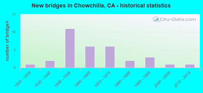
- New bridges - historical statistics
- 11930-1939
- 21940-1949
- 111950-1959
- 61960-1969
- 61970-1979
- 21980-1989
- 31990-1999
- 12000-2009
- 12010-2019


- Bridge Condition - Deck
- 53.3%Good
- 10.0%Satisfactory
- 26.7%Fair
- 10.0%Poor

- Bridge Condition - Superstructure
- 50.0%Good
- 10.0%Satisfactory
- 23.3%Fair
- 16.7%Poor

- Bridge Condition - Substructure
- 63.3%Good
- 26.7%Fair
- 6.7%Poor
- 3.3%Critical

- Bridge Condition - Channel
- 11.1%Very good
- 55.6%Good
- 7.4%Satisfactory
- 18.5%Fair
- 7.4%Poor
Find on map >> Show street view
Structure Number: 39 0240R, Location: 10-MER-099-1.60 (Lat: 37.170072, Lng: -120.309294), Route carried "on" structure: State highway 99, Year Built: 2015, Status: Open, Structure Length: 1.35m (4.43ft), Average Daily Traffic: 19,500 (year 2009), Average Future Daily Traffic: 27,903 (year 2038), Design Load: Greater than HL93, Features Intersected: SOUTH DUTCHMAN CREEK
Minimum Vertical Clearance: 30+ m (98+ ft), Kilometerpoint: 1.600, Lanes on structure: 3, Base Highway Network: Yes (, Subroute: 1), Owner: State Highway Agency, Approaching Roadway Width: 17.1m (56.1ft), Material/Design: Concrete, Design/Construction: Slab, Number Of Spans In Main Unit: 1, Length of Maximum Span: 12.2m (40.0ft), Curb-To-Curb Width: 17.1m (56.1ft), Out-to-Out Width: 18.0m (59.1ft)
Condition: Deck: Good, Superstructure: Good, Substructure: Good, Channel: Very good, Operating Rating: 42.1 metric tons, Method Used To Determine Operating Rating: Assigned ratings based on Load and Resistance Factor Design (LRFD) reported by rating factor (RF) using HL93 loadings, Inventory Rating: 32.4 metric tons, Method Used To Determine Inventory Rating: Assigned ratings based on Load and Resistance Factor Design (LRFD) reported by rating factor (RF) using HL93 loadings, Structural Evaluation: Better than present minimum criteria, Deck Geometry: Superior to present desirable criteria, Waterway Adequacy: Equal to present desirable criteria, Approach Roadway Alignment: Equal to present desirable criteria, Designated Inspection Frequency: Every 48 months, Inspection Date: April 2018, Deck Structure Type: Concrete Cast-file-Place
Find on map >> Show street view
Structure Number: 39C0413, Location: 0.4 MI N OF CROSS RD (Lat: 37.169767, Lng: -120.311517), Route carried "on" structure: County highway , Year Built: 1940, Year Reconstructed: 1993, Status: Open, Structure Length: 1.80m (5.91ft), Average Daily Traffic: 5,000 (year 2014), Average Future Daily Traffic: 6,121 (year 2042), Design Load: HS 20, Features Intersected: SOUTH DUTCHMAN CREEK, Facility Carried by Structure: SOUTH VISTA AVE
Minimum Vertical Clearance: 30+ m (98+ ft), Kilometerpoint: 0.000, Lanes on structure: 2, Base Highway Network: Yes, Owner: County Highway Agency, Approaching Roadway Width: 15.5m (50.9ft), Material/Design: Concrete continuous, Design/Construction: Slab, Number Of Spans In Main Unit: 5, Length of Maximum Span: 4.8m (15.7ft), Curb-To-Curb Width: 15.5m (50.9ft), Out-to-Out Width: 16.5m (54.1ft)
Condition: Deck: Good, Superstructure: Good, Substructure: Good, Channel: Good, Operating Rating: 49.9 metric tons, Method Used To Determine Operating Rating: Load Factor (LF), Inventory Rating: 29.8 metric tons, Method Used To Determine Inventory Rating: Load Factor (LF), Structural Evaluation: Better than present minimum criteria, Deck Geometry: Superior to present desirable criteria, Waterway Adequacy: Better than present minimum criteria, Approach Roadway Alignment: Equal to present desirable criteria, Designated Inspection Frequency: Every 24 months, Inspection Date: September 2020, Deck Structure Type: Concrete Cast-file-Place, Wearing Surface/Protective System: Wearing Surface: Bituminous
Find on map >> Show street view
Structure Number: 41 0001, Location: 06-MAD-099-29.33 (Lat: 37.152433, Lng: -120.290281), Route carried "on" structure: State highway 99, Year Built: 1995, Status: Open, Structure Length: 3.41m (11.19ft), Average Daily Traffic: 37,500 (year 2009), Truck Traffic: 27%, Average Future Daily Traffic: 68,155 (year 2043), Design Load: HS 20+Mod, Features Intersected: CHOWCHILLA RIVER
Minimum Vertical Clearance: 30+ m (98+ ft), Kilometerpoint: 29.330, Lanes on structure: 4, Base Highway Network: Yes (, Subroute: 1), Owner: State Highway Agency, Approaching Roadway Width: 29.6m (97.1ft), Skew: 31 degrees, Material/Design: Concrete continuous, Design/Construction: Box Beam or Girders - Multiple, Number Of Spans In Main Unit: 2, Length of Maximum Span: 17.1m (56.1ft), Curb-To-Curb Width: 29.1m (95.5ft), Out-to-Out Width: 30.8m (101.0ft)
Condition: Deck: Good, Superstructure: Good, Substructure: Good, Channel: Poor, Operating Rating: 54.1 metric tons, Method Used To Determine Operating Rating: Assigned rating based on Load Factor Design (LFD) reported in metric tons, Inventory Rating: 32.4 metric tons, Method Used To Determine Inventory Rating: Assigned rating based on Load Factor Design (LFD) reported in metric tons, Structural Evaluation: Better than present minimum criteria, Deck Geometry: Superior to present desirable criteria, Waterway Adequacy: Meets minimum limits, Approach Roadway Alignment: Equal to present desirable criteria, Designated Inspection Frequency: Every 24 months, Inspection Date: June 2021, Deck Structure Type: Concrete Cast-file-Place
Find on map >> Show street view
Structure Number: 41 0009L, Location: 06-MAD-152-12.37 (Lat: 37.083678, Lng: -120.269175), Route carried "on" structure: State highway 152, Year Built: 1968, Status: Open, Structure Length: 11.06m (36.29ft), Average Daily Traffic: 15,000 (year 2009), Truck Traffic: 25%, Average Future Daily Traffic: 18,548 (year 2041), Design Load: HS 20+Mod, Features Intersected: BERENDA SLOUGH
Minimum Vertical Clearance: 30+ m (98+ ft), Kilometerpoint: 12.370, Lanes on structure: 2, Base Highway Network: Yes (Inventory Route: 1, Subroute: 1), Owner: State Highway Agency, Approaching Roadway Width: 11.3m (37.1ft), Skew: 4 degrees, Material/Design: Concrete continuous, Design/Construction: Tee Beam, Number Of Spans In Main Unit: 10, Length of Maximum Span: 11.6m (38.1ft), Curb-To-Curb Width: 9.8m (32.2ft), Out-to-Out Width: 10.4m (34.1ft)
Condition: Deck: Fair, Superstructure: Good, Substructure: Good, Channel: Good, Operating Rating: 36.3 metric tons, Method Used To Determine Operating Rating: Load and Resistance Factor Rating (LRFR) rating reported by rating factor(RF) method using HL-93 loadings, Inventory Rating: 28.2 metric tons, Method Used To Determine Inventory Rating: Load and Resistance Factor Rating (LRFR) rating reported by rating factor(RF) method using HL-93 loadings, Structural Evaluation: Better than present minimum criteria, Deck Geometry: Meets minimum limits, Waterway Adequacy: Equal to present minimum criteria, Approach Roadway Alignment: Equal to present desirable criteria, Designated Inspection Frequency: Every 24 months, Inspection Date: November 2020, Deck Structure Type: Concrete Cast-file-Place, Wearing Surface/Protective System: Wearing Surface: Bituminous
Find on map >> Show street view
Structure Number: 41 0009R, Location: 06-MAD-152-12.37 (Lat: 37.083528, Lng: -120.269372), Route carried "on" structure: State highway 152, Year Built: 2000, Status: Open, Structure Length: 11.36m (37.27ft), Average Daily Traffic: 15,000 (year 2009), Truck Traffic: 25%, Average Future Daily Traffic: 13,096 (year 2041), Design Load: HS 20+Mod, Features Intersected: BERENDA SLOUGH
Minimum Vertical Clearance: 30+ m (98+ ft), Kilometerpoint: 12.370, Lanes on structure: 2, Base Highway Network: Yes (Inventory Route: 1, Subroute: 1), Owner: State Highway Agency, Approaching Roadway Width: 12.8m (42.0ft), Skew: 4 degrees, Material/Design: Concrete continuous, Design/Construction: Box Beam or Girders - Multiple, Number Of Spans In Main Unit: 5, Length of Maximum Span: 23.2m (76.1ft), Curb-To-Curb Width: 11.8m (38.7ft), Out-to-Out Width: 12.8m (42.0ft)
Condition: Deck: Fair, Superstructure: Good, Substructure: Good, Channel: Good, Operating Rating: 54.1 metric tons, Method Used To Determine Operating Rating: Assigned rating based on Load Factor Design (LFD) reported in metric tons, Inventory Rating: 32.4 metric tons, Method Used To Determine Inventory Rating: Assigned rating based on Load Factor Design (LFD) reported in metric tons, Structural Evaluation: Better than present minimum criteria, Deck Geometry: Better than present minimum criteria, Waterway Adequacy: Equal to present desirable criteria, Approach Roadway Alignment: Equal to present desirable criteria, Length Of Structure Improvement: 11.06m (36.29ft), Designated Inspection Frequency: Every 24 months, Inspection Date: November 2020, Deck Structure Type: Concrete Cast-file-Place
Find on map >> Show street view
Structure Number: 41 0044L, Location: 06-MAD-099-24.78 (Lat: 37.108783, Lng: -120.228836), Route carried "on" structure: State highway 99, Year Built: 1957, Year Reconstructed: 1993, Status: Open, Structure Length: 11.98m (39.30ft), Average Daily Traffic: 19,250 (year 2009), Truck Traffic: 27%, Average Future Daily Traffic: 34,345 (year 2043), Design Load: HS 20, Features Intersected: BERENDA SLOUGH
Minimum Vertical Clearance: 30+ m (98+ ft), Kilometerpoint: 24.780, Lanes on structure: 2, Base Highway Network: Yes (, Subroute: 1), Owner: State Highway Agency, Approaching Roadway Width: 11.9m (39.0ft), Material/Design: Concrete continuous, Design/Construction: Slab, Number Of Spans In Main Unit: 15, Length of Maximum Span: 7.9m (25.9ft), Curb-To-Curb Width: 11.9m (39.0ft), Out-to-Out Width: 13.0m (42.7ft)
Condition: Deck: Poor, Superstructure: Poor, Substructure: Fair, Channel: Fair, Operating Rating: 42.1 metric tons, Method Used To Determine Operating Rating: Load and Resistance Factor Rating (LRFR) rating reported by rating factor(RF) method using HL-93 loadings, Inventory Rating: 32.4 metric tons, Method Used To Determine Inventory Rating: Load and Resistance Factor Rating (LRFR) rating reported by rating factor(RF) method using HL-93 loadings, Structural Evaluation: Meets minimum limits, Deck Geometry: Equal to present minimum criteria, Waterway Adequacy: Better than present minimum criteria, Approach Roadway Alignment: Equal to present desirable criteria, Length Of Structure Improvement: 11.98m (39.30ft), Designated Inspection Frequency: Every 24 months, Inspection Date: June 2021, Bridge Improvement Cost: $1,557,000, Roadway Improvement Cost: $311,000, Total Project Cost: $2,615,000 ( Estimate for 2020), Deck Structure Type: Concrete Cast-file-Place
Find on map >> Show street view
Structure Number: 41 0044R, Location: 06-MAD-099-24.78 (Lat: 37.108933, Lng: -120.228661), Route carried "on" structure: State highway 99, Year Built: 1957, Year Reconstructed: 1993, Status: Open, Structure Length: 11.98m (39.30ft), Average Daily Traffic: 19,250 (year 2009), Truck Traffic: 27%, Average Future Daily Traffic: 34,345 (year 2043), Design Load: HS 20, Features Intersected: BERENDA SLOUGH
Minimum Vertical Clearance: 30+ m (98+ ft), Kilometerpoint: 24.780, Lanes on structure: 2, Base Highway Network: Yes (, Subroute: 1), Owner: State Highway Agency, Approaching Roadway Width: 11.9m (39.0ft), Material/Design: Concrete continuous, Design/Construction: Slab, Number Of Spans In Main Unit: 15, Length of Maximum Span: 7.9m (25.9ft), Curb-To-Curb Width: 11.9m (39.0ft), Out-to-Out Width: 13.0m (42.7ft)
Condition: Deck: Good, Superstructure: Good, Substructure: Good, Channel: Fair, Operating Rating: 54.1 metric tons, Method Used To Determine Operating Rating: Assigned rating based on Load Factor Design (LFD) reported in metric tons, Inventory Rating: 32.4 metric tons, Method Used To Determine Inventory Rating: Assigned rating based on Load Factor Design (LFD) reported in metric tons, Structural Evaluation: Better than present minimum criteria, Deck Geometry: Equal to present minimum criteria, Waterway Adequacy: Better than present minimum criteria, Approach Roadway Alignment: Equal to present desirable criteria, Designated Inspection Frequency: Every 24 months, Inspection Date: June 2021, Deck Structure Type: Concrete Cast-file-Place
Find on map >> Show street view
Structure Number: 41 0045L, Location: 06-MAD-099-26.80 (Lat: 37.128986, Lng: -120.255456), Route carried "on" structure: State highway 99, Year Built: 1957, Year Reconstructed: 1993, Status: Open, Structure Length: 12.89m (42.29ft), Average Daily Traffic: 19,250 (year 2009), Truck Traffic: 27%, Average Future Daily Traffic: 34,345 (year 2043), Design Load: HS 20, Features Intersected: ASH SLOUGH
Minimum Vertical Clearance: 30+ m (98+ ft), Kilometerpoint: 26.800, Lanes on structure: 2, Base Highway Network: Yes (, Subroute: 1), Owner: State Highway Agency, Approaching Roadway Width: 11.9m (39.0ft), Material/Design: Concrete continuous, Design/Construction: Slab, Number Of Spans In Main Unit: 21, Length of Maximum Span: 6.1m (20.0ft), Curb-To-Curb Width: 11.9m (39.0ft), Out-to-Out Width: 13.0m (42.7ft)
Condition: Deck: Fair, Superstructure: Fair, Substructure: Good, Channel: Fair, Operating Rating: 32.7 metric tons, Method Used To Determine Operating Rating: Load and Resistance Factor Rating (LRFR) rating reported by rating factor(RF) method using HL-93 loadings, Inventory Rating: 25.3 metric tons, Method Used To Determine Inventory Rating: Load and Resistance Factor Rating (LRFR) rating reported by rating factor(RF) method using HL-93 loadings, Structural Evaluation: Somewhat better than minimum adequacy, Deck Geometry: Equal to present minimum criteria, Waterway Adequacy: Equal to present minimum criteria, Approach Roadway Alignment: Equal to present desirable criteria, Designated Inspection Frequency: Every 24 months, Inspection Date: June 2021, Deck Structure Type: Concrete Cast-file-Place
Find on map >> Show street view
Structure Number: 41 0045R, Location: 06-MAD-099-26.80 (Lat: 37.129142, Lng: -120.255289), Route carried "on" structure: State highway 99, Year Built: 1957, Year Reconstructed: 1993, Status: Open, Structure Length: 12.89m (42.29ft), Average Daily Traffic: 19,250 (year 2009), Truck Traffic: 27%, Average Future Daily Traffic: 34,345 (year 2043), Design Load: HS 20, Features Intersected: ASH SLOUGH
Minimum Vertical Clearance: 30+ m (98+ ft), Kilometerpoint: 26.800, Lanes on structure: 2, Base Highway Network: Yes (, Subroute: 1), Owner: State Highway Agency, Approaching Roadway Width: 11.9m (39.0ft), Material/Design: Concrete continuous, Design/Construction: Slab, Number Of Spans In Main Unit: 21, Length of Maximum Span: 6.1m (20.0ft), Curb-To-Curb Width: 11.9m (39.0ft), Out-to-Out Width: 13.0m (42.7ft)
Condition: Deck: Good, Superstructure: Good, Substructure: Good, Channel: Fair, Operating Rating: 32.7 metric tons, Method Used To Determine Operating Rating: Load and Resistance Factor Rating (LRFR) rating reported by rating factor(RF) method using HL-93 loadings, Inventory Rating: 25.3 metric tons, Method Used To Determine Inventory Rating: Load and Resistance Factor Rating (LRFR) rating reported by rating factor(RF) method using HL-93 loadings, Structural Evaluation: Equal to present minimum criteria, Deck Geometry: Equal to present minimum criteria, Waterway Adequacy: Equal to present minimum criteria, Approach Roadway Alignment: Equal to present desirable criteria, Designated Inspection Frequency: Every 24 months, Inspection Date: June 2021, Deck Structure Type: Concrete Cast-file-Place
Find on map >> Show street view
Structure Number: 41 0055E, Location: 06-MAD-233-3.87 (Lat: 37.126814, Lng: -120.252556), Route carried "on" structure: Ramp State highway 233, Year Built: 1957, Status: Open, Structure Length: 4.52m (14.83ft), Average Daily Traffic: 11,000 (year 2009), Truck Traffic: 8%, Average Future Daily Traffic: 15,876 (year 2041), Design Load: HS 20, Features Intersected: STATE ROUTE 99
Minimum Vertical Clearance: 30+ m (98+ ft), Kilometerpoint: 3.870, Lanes on structure: 2, Lanes under structure: 4, Base Highway Network: Yes (Inventory Route: 2, Subroute: 1), Owner: State Highway Agency, Approaching Roadway Width: 12.2m (40.0ft), Skew: 3 degrees, Material/Design: Concrete continuous, Design/Construction: Box Beam or Girders - Multiple, Number Of Spans In Main Unit: 2, Length of Maximum Span: 21.6m (70.9ft), Curb or Sidewalk Widths: Left: 1.5m (4.9ft), Right: 0.6m (2.0ft), Curb-To-Curb Width: 8.5m (27.9ft), Out-to-Out Width: 10.8m (35.4ft)
Condition: Deck: Good, Superstructure: Good, Substructure: Good, Operating Rating: 52.8 metric tons, Method Used To Determine Operating Rating: Load and Resistance Factor Rating (LRFR) rating reported by rating factor(RF) method using HL-93 loadings, Inventory Rating: 37.9 metric tons, Method Used To Determine Inventory Rating: Load and Resistance Factor Rating (LRFR) rating reported by rating factor(RF) method using HL-93 loadings, Structural Evaluation: Better than present minimum criteria, Deck Geometry: High priority of corrective action, Underclear: High priority of corrective action, Approach Roadway Alignment: Equal to present desirable criteria, Designated Inspection Frequency: Every 24 months, Inspection Date: November 2020, Deck Structure Type: Concrete Cast-file-Place, Wearing Surface/Protective System: Wearing Surface: Bituminous
Find on map >> Show street view
Structure Number: 41 0057, Location: 06-MAD-099-28.17 (Lat: 37.141369, Lng: -120.274336), Route carried "on" structure: County highway W350, Year Built: 1957, Status: Open, Structure Length: 7.80m (25.59ft), Average Daily Traffic: 1,620 (year 1998), Truck Traffic: 10%, Average Future Daily Traffic: 1,287 (year 2036), Design Load: HS 20, Features Intersected: SR 99, Facility Carried by Structure: CO RD 15 \ MINTURN
Minimum Vertical Clearance: 30+ m (98+ ft), Kilometerpoint: 0.000, Lanes on structure: 2, Lanes under structure: 5, Owner: State Highway Agency, Approaching Roadway Width: 9.8m (32.2ft), Skew: 2 degrees, Material/Design: Concrete continuous, Design/Construction: Box Beam or Girders - Multiple, Number Of Spans In Main Unit: 4, Length of Maximum Span: 29.6m (97.1ft), Curb or Sidewalk Widths: Left: 0.5m (1.6ft), Right: 0.5m (1.6ft), Curb-To-Curb Width: 8.5m (27.9ft), Out-to-Out Width: 10.1m (33.1ft)
Condition: Deck: Good, Superstructure: Good, Substructure: Good, Operating Rating: 39.9 metric tons, Method Used To Determine Operating Rating: Load and Resistance Factor Rating (LRFR) rating reported by rating factor(RF) method using HL-93 loadings, Inventory Rating: 30.8 metric tons, Method Used To Determine Inventory Rating: Load and Resistance Factor Rating (LRFR) rating reported by rating factor(RF) method using HL-93 loadings, Structural Evaluation: Better than present minimum criteria, Deck Geometry: Somewhat better than minimum adequacy, Underclear: Meets minimum limits, Approach Roadway Alignment: Somewhat better than minimum adequacy, Designated Inspection Frequency: Every 48 months, Inspection Date: June 2019, Deck Structure Type: Concrete Cast-file-Place
Find on map >> Show street view
Structure Number: 41 0059E, Location: 06-MAD-233-0.01 (Lat: 37.083167, Lng: -120.297600), Route carried "on" structure: Ramp State highway 233, Year Built: 1968, Status: Open, Structure Length: 8.16m (26.77ft), Average Daily Traffic: 4,100 (year 2009), Truck Traffic: 10%, Average Future Daily Traffic: 7,263 (year 2041), Design Load: HS 20+Mod, Features Intersected: STATE ROUTE 152
Minimum Vertical Clearance: 30+ m (98+ ft), Kilometerpoint: 0.010, Lanes on structure: 2, Lanes under structure: 5, Owner: State Highway Agency, Approaching Roadway Width: 12.2m (40.0ft), Skew: 3 degrees, Material/Design: Prestressed concrete continuous, Design/Construction: Stringer/Multi-beam, Number Of Spans In Main Unit: 2, Length of Maximum Span: 32.9m (107.9ft), Curb or Sidewalk Widths: Left: 0.0m, Right: 1.5m (4.9ft), Curb-To-Curb Width: 12.2m (40.0ft), Out-to-Out Width: 14.3m (46.9ft)
Condition: Deck: Good, Superstructure: Good, Substructure: Good, Operating Rating: 84.6 metric tons, Method Used To Determine Operating Rating: Load Factor (LF), Inventory Rating: 32.4 metric tons, Method Used To Determine Inventory Rating: Load Factor (LF), Structural Evaluation: Better than present minimum criteria, Deck Geometry: Superior to present desirable criteria, Underclear: Equal to present minimum criteria, Approach Roadway Alignment: Equal to present desirable criteria, Designated Inspection Frequency: Every 24 months, Inspection Date: November 2020, Deck Structure Type: Concrete Cast-file-Place, Wearing Surface/Protective System: Wearing Surface: Bituminous
Find on map >> Show street view
Structure Number: 41C0012, Location: 0.2 MI N/W OF AVE 27 (Lat: 37.143267, Lng: -120.161967), Route carried "on" structure: County highway , Year Built: 1968, Status: Open, Structure Length: 5.55m (18.21ft), Average Daily Traffic: 259 (year 1979), Truck Traffic: 7%, Average Future Daily Traffic: 655 (year 2041), Design Load: HS 20, Features Intersected: BERENDA SLOUGH, Facility Carried by Structure: SANTA FE BLVD
Minimum Vertical Clearance: 30+ m (98+ ft), Kilometerpoint: 0.000, Lanes on structure: 2, Owner: County Highway Agency, Approaching Roadway Width: 7.0m (23.0ft), Material/Design: Concrete continuous, Design/Construction: Slab, Number Of Spans In Main Unit: 6, Length of Maximum Span: 9.1m (29.9ft), Curb-To-Curb Width: 9.2m (30.2ft), Out-to-Out Width: 9.4m (30.8ft)
Condition: Deck: Poor, Superstructure: Poor, Substructure: Fair, Channel: Satisfactory, Operating Rating: 33.7 metric tons, Method Used To Determine Operating Rating: Load and Resistance Factor Rating (LRFR) rating reported by rating factor(RF) method using HL-93 loadings, Inventory Rating: 24.3 metric tons, Method Used To Determine Inventory Rating: Load and Resistance Factor Rating (LRFR) rating reported by rating factor(RF) method using HL-93 loadings, Structural Evaluation: Meets minimum limits, Deck Geometry: Equal to present minimum criteria, Waterway Adequacy: Better than present minimum criteria, Approach Roadway Alignment: Better than present minimum criteria, Length Of Structure Improvement: 5.55m (18.21ft), Designated Inspection Frequency: Every 24 months, Inspection Date: March 2021, Bridge Improvement Cost: $519,000, Roadway Improvement Cost: $238,000, Total Project Cost: $2,005,000 ( Estimate for 2017), Deck Structure Type: Concrete Cast-file-Place
Find on map >> Show street view
Structure Number: 41C0032, Location: 0.5 MI W RD 13 (Lat: 37.113806, Lng: -120.320822), Route carried "on" structure: County highway , Year Built: 1954, Status: Open, Structure Length: 10.49m (34.42ft), Average Daily Traffic: 950 (year 2010), Truck Traffic: 9%, Average Future Daily Traffic: 1,532 (year 2042), Design Load: HS 20, Features Intersected: ASH SLOUGH, Facility Carried by Structure: AVE 25
Minimum Vertical Clearance: 30+ m (98+ ft), Kilometerpoint: 0.000, Lanes on structure: 2, Owner: County Highway Agency, Approaching Roadway Width: 7.0m (23.0ft), Material/Design: Concrete continuous, Design/Construction: Slab, Number Of Spans In Main Unit: 16, Length of Maximum Span: 6.7m (22.0ft), Curb or Sidewalk Widths: Left: 0.3m (1.0ft), Right: 0.3m (1.0ft), Curb-To-Curb Width: 7.9m (25.9ft), Out-to-Out Width: 8.7m (28.5ft)
Condition: Deck: Good, Superstructure: Good, Substructure: Critical, Channel: Fair, Operating Rating: 33.0 metric tons, Method Used To Determine Operating Rating: Load and Resistance Factor Rating (LRFR) rating reported by rating factor(RF) method using HL-93 loadings, Inventory Rating: 25.6 metric tons, Method Used To Determine Inventory Rating: Load and Resistance Factor Rating (LRFR) rating reported by rating factor(RF) method using HL-93 loadings, Structural Evaluation: High priority of replacement, Deck Geometry: Somewhat better than minimum adequacy, Waterway Adequacy: Better than present minimum criteria, Approach Roadway Alignment: Equal to present minimum criteria, Length Of Structure Improvement: 10.49m (34.42ft), Designated Inspection Frequency: Every 24 months, Inspection Date: January 2022, Bridge Improvement Cost: $2,088,000, Roadway Improvement Cost: $417,000, Total Project Cost: $3,508,000 ( Estimate for 2017), Deck Structure Type: Concrete Cast-file-Place, Wearing Surface/Protective System: Wearing Surface: Bituminous
Find on map >> Show street view
Structure Number: 41C0033, Location: 0.6 MI N OF AVE 23 (Lat: 37.099775, Lng: -120.256714), Route carried "on" structure: County highway , Year Built: 1974, Status: Open, Structure Length: 5.21m (17.09ft), Average Daily Traffic: 1,560 (year 1979), Truck Traffic: 6%, Average Future Daily Traffic: 6,265 (year 2042), Design Load: HS 20, Features Intersected: BERENDA SLOUGH, Facility Carried by Structure: ROAD 16
Minimum Vertical Clearance: 30+ m (98+ ft), Kilometerpoint: 0.000, Lanes on structure: 2, Owner: City or Municipal Highway Agency, Approaching Roadway Width: 10.7m (35.1ft), Skew: 2 degrees, Material/Design: Concrete continuous, Design/Construction: Slab, Number Of Spans In Main Unit: 6, Length of Maximum Span: 8.5m (27.9ft), Curb-To-Curb Width: 11.0m (36.1ft), Out-to-Out Width: 11.2m (36.7ft)
Condition: Deck: Fair, Superstructure: Fair, Substructure: Fair, Channel: Poor, Operating Rating: 33.4 metric tons, Method Used To Determine Operating Rating: Load and Resistance Factor Rating (LRFR) rating reported by rating factor(RF) method using HL-93 loadings, Inventory Rating: 25.9 metric tons, Method Used To Determine Inventory Rating: Load and Resistance Factor Rating (LRFR) rating reported by rating factor(RF) method using HL-93 loadings, Structural Evaluation: Somewhat better than minimum adequacy, Deck Geometry: Equal to present minimum criteria, Waterway Adequacy: Better than present minimum criteria, Approach Roadway Alignment: Better than present minimum criteria, Designated Inspection Frequency: Every 24 months, Inspection Date: January 2022, Deck Structure Type: Concrete Cast-file-Place
Find on map >> Show street view
Structure Number: 41C0034, Location: 0.8 MI N AVE 26 (Lat: 37.137922, Lng: -120.202075), Route carried "on" structure: County highway , Year Built: 1981, Status: Open, Structure Length: 8.63m (28.31ft), Average Daily Traffic: 142 (year 1979), Truck Traffic: 10%, Average Future Daily Traffic: 273 (year 2042), Design Load: HS 20, Features Intersected: ASH SLOUGH, Facility Carried by Structure: ROAD 19
Minimum Vertical Clearance: 30+ m (98+ ft), Kilometerpoint: 0.000, Lanes on structure: 2, Owner: County Highway Agency, Approaching Roadway Width: 8.8m (28.9ft), Skew: 1 degrees, Material/Design: Concrete continuous, Design/Construction: Slab, Number Of Spans In Main Unit: 10, Length of Maximum Span: 8.5m (27.9ft), Curb-To-Curb Width: 9.1m (29.9ft), Out-to-Out Width: 9.3m (30.5ft)
Condition: Deck: Satisfactory, Superstructure: Satisfactory, Substructure: Good, Channel: Good, Operating Rating: 57.7 metric tons, Method Used To Determine Operating Rating: Load Factor (LF), Inventory Rating: 34.7 metric tons, Method Used To Determine Inventory Rating: Load Factor (LF), Structural Evaluation: Equal to present minimum criteria, Deck Geometry: Equal to present minimum criteria, Waterway Adequacy: Equal to present desirable criteria, Approach Roadway Alignment: Equal to present desirable criteria, Designated Inspection Frequency: Every 48 months, Inspection Date: January 2020, Deck Structure Type: Concrete Cast-file-Place
Find on map >> Show street view
Structure Number: 41C0035, Location: 0.7 MI N OF AVE 28 (Lat: 37.164483, Lng: -120.174806), Route carried "on" structure: County highway , Year Built: 1973, Status: Open, Structure Length: 2.65m (8.69ft), Average Daily Traffic: 259 (year 1979), Truck Traffic: 5%, Average Future Daily Traffic: 764 (year 2041), Design Load: HS 20+Mod, Features Intersected: CHOWCHILLA RIVER, Facility Carried by Structure: SANTA FE BLVD
Minimum Vertical Clearance: 30+ m (98+ ft), Kilometerpoint: 0.000, Lanes on structure: 2, Owner: County Highway Agency, Approaching Roadway Width: 6.7m (22.0ft), Skew: 3 degrees, Material/Design: Concrete continuous, Design/Construction: Slab, Number Of Spans In Main Unit: 3, Length of Maximum Span: 8.5m (27.9ft), Curb-To-Curb Width: 9.2m (30.2ft), Out-to-Out Width: 9.4m (30.8ft)
Condition: Deck: Good, Superstructure: Good, Substructure: Fair, Channel: Satisfactory, Operating Rating: 34.0 metric tons, Method Used To Determine Operating Rating: Load and Resistance Factor Rating (LRFR) rating reported by rating factor(RF) method using HL-93 loadings, Inventory Rating: 26.2 metric tons, Method Used To Determine Inventory Rating: Load and Resistance Factor Rating (LRFR) rating reported by rating factor(RF) method using HL-93 loadings, Structural Evaluation: Somewhat better than minimum adequacy, Deck Geometry: Equal to present minimum criteria, Waterway Adequacy: Equal to present minimum criteria, Approach Roadway Alignment: Equal to present minimum criteria, Designated Inspection Frequency: Every 24 months, Inspection Date: March 2021, Deck Structure Type: Concrete Cast-file-Place, Wearing Surface/Protective System: Wearing Surface: Bituminous
Find on map >> Show street view
Structure Number: 41C0036, Location: 0.36 MI N OF AVE 27 (Lat: 37.146256, Lng: -120.163897), Route carried "on" structure: County highway , Year Built: 1956, Status: Open, Structure Length: 12.31m (40.39ft), Average Daily Traffic: 259 (year 1979), Truck Traffic: 8%, Average Future Daily Traffic: 764 (year 2041), Design Load: HS 20, Features Intersected: ASH SLOUGH, Facility Carried by Structure: SANTA FE BLVD
Minimum Vertical Clearance: 30+ m (98+ ft), Kilometerpoint: 0.000, Lanes on structure: 2, Owner: County Highway Agency, Approaching Roadway Width: 6.7m (22.0ft), Material/Design: Concrete continuous, Design/Construction: Slab, Number Of Spans In Main Unit: 10, Length of Maximum Span: 12.2m (40.0ft), Curb-To-Curb Width: 8.0m (26.2ft), Out-to-Out Width: 8.2m (26.9ft)
Condition: Deck: Poor, Superstructure: Poor, Substructure: Poor, Channel: Good, Operating Rating: 34.7 metric tons, Method Used To Determine Operating Rating: Load and Resistance Factor Rating (LRFR) rating reported by rating factor(RF) method using HL-93 loadings, Inventory Rating: 24.6 metric tons, Method Used To Determine Inventory Rating: Load and Resistance Factor Rating (LRFR) rating reported by rating factor(RF) method using HL-93 loadings, Structural Evaluation: Meets minimum limits, Deck Geometry: Somewhat better than minimum adequacy, Waterway Adequacy: Equal to present desirable criteria, Approach Roadway Alignment: Equal to present desirable criteria, Length Of Structure Improvement: 12.31m (40.39ft), Designated Inspection Frequency: Every 24 months, Inspection Date: March 2021, Bridge Improvement Cost: $1,002,000, Roadway Improvement Cost: $200,000, Total Project Cost: $1,683,000 ( Estimate for 2017), Deck Structure Type: Concrete Cast-file-Place
Find on map >> Show street view
Structure Number: 41C0041, Location: 0.2 MI NW AVE 24 1/2 (Lat: 37.105872, Lng: -120.233567), Route carried "on" structure: County highway , Year Built: 1931, Status: Open, Structure Length: 14.60m (47.90ft), Average Daily Traffic: 1,446 (year 1979), Truck Traffic: 7%, Average Future Daily Traffic: 2,896 (year 2042), Features Intersected: BERENDA SLOUGH, Facility Carried by Structure: CHOWCHILLA BLVD
Minimum Vertical Clearance: 30+ m (98+ ft), Kilometerpoint: 0.000, Lanes on structure: 2, Owner: City or Municipal Highway Agency, Approaching Roadway Width: 8.5m (27.9ft), Material/Design: Concrete, Design/Construction: Tee Beam, Number Of Spans In Main Unit: 18, Length of Maximum Span: 8.1m (26.6ft), Curb or Sidewalk Widths: Left: 0.5m (1.6ft), Right: 0.5m (1.6ft), Curb-To-Curb Width: 7.3m (24.0ft), Out-to-Out Width: 8.6m (28.2ft)
Condition: Deck: Good, Superstructure: Poor, Substructure: Poor, Channel: Good, Operating Rating: 32.7 metric tons, Method Used To Determine Operating Rating: Load and Resistance Factor Rating (LRFR) rating reported by rating factor(RF) method using HL-93 loadings, Inventory Rating: 25.3 metric tons, Method Used To Determine Inventory Rating: Load and Resistance Factor Rating (LRFR) rating reported by rating factor(RF) method using HL-93 loadings, Structural Evaluation: Meets minimum limits, Deck Geometry: Meets minimum limits, Waterway Adequacy: Better than present minimum criteria, Approach Roadway Alignment: Equal to present desirable criteria, Length Of Structure Improvement: 14.60m (47.90ft), Designated Inspection Frequency: Every 24 months, Inspection Date: January 2022, Bridge Improvement Cost: $2,875,000, Deck Structure Type: Concrete Cast-file-Place, Wearing Surface/Protective System: Wearing Surface: Bituminous
Find on map >> Show street view
Structure Number: 41C0042, Location: 0.2 MI N ROBERTSON BLVD (Lat: 37.126922, Lng: -120.259236), Route carried "on" structure: City street , Year Built: 1988, Status: Open, Structure Length: 6.92m (22.70ft), Average Daily Traffic: 1,900 (year 1983), Truck Traffic: 7%, Average Future Daily Traffic: 6,608 (year 2041), Design Load: HS 20+Mod, Features Intersected: ASH SLOUGH, Facility Carried by Structure: CHOWCHILLA BLVD
Minimum Vertical Clearance: 30+ m (98+ ft), Kilometerpoint: 0.000, Lanes on structure: 2, Owner: City or Municipal Highway Agency, Approaching Roadway Width: 12.4m (40.7ft), Skew: 2 degrees, Material/Design: Concrete continuous, Design/Construction: Slab, Number Of Spans In Main Unit: 8, Length of Maximum Span: 8.6m (28.2ft), Curb-To-Curb Width: 12.4m (40.7ft), Out-to-Out Width: 12.6m (41.3ft)
Condition: Deck: Fair, Superstructure: Fair, Substructure: Good, Channel: Good, Operating Rating: 54.1 metric tons, Method Used To Determine Operating Rating: Assigned rating based on Load Factor Design (LFD) reported in metric tons, Inventory Rating: 32.4 metric tons, Method Used To Determine Inventory Rating: Assigned rating based on Load Factor Design (LFD) reported in metric tons, Structural Evaluation: Somewhat better than minimum adequacy, Deck Geometry: Better than present minimum criteria, Waterway Adequacy: Better than present minimum criteria, Approach Roadway Alignment: Better than present minimum criteria, Designated Inspection Frequency: Every 24 months, Inspection Date: March 2021, Deck Structure Type: Concrete Cast-file-Place
Find on map >> Show street view
Structure Number: 41C0066, Location: SOUTH MERCED COUNTY LINE (Lat: 37.151853, Lng: -120.274328), Route carried "on" structure: County highway , Year Built: 1974, Status: Open, Structure Length: 2.80m (9.19ft), Average Daily Traffic: 1,051 (year 1976), Truck Traffic: 6%, Average Future Daily Traffic: 4,362 (year 2041), Design Load: HS 20, Features Intersected: CHOWCHILLA RIVER, Facility Carried by Structure: ROAD 15
Minimum Vertical Clearance: 30+ m (98+ ft), Kilometerpoint: 0.000, Lanes on structure: 2, Owner: County Highway Agency, Approaching Roadway Width: 9.8m (32.2ft), Material/Design: Concrete continuous, Design/Construction: Slab, Number Of Spans In Main Unit: 3, Length of Maximum Span: 9.1m (29.9ft), Curb-To-Curb Width: 11.0m (36.1ft), Out-to-Out Width: 11.2m (36.7ft)
Condition: Deck: Fair, Superstructure: Fair, Substructure: Good, Channel: Good, Operating Rating: 54.4 metric tons, Method Used To Determine Operating Rating: Load Factor (LF), Inventory Rating: 32.7 metric tons, Method Used To Determine Inventory Rating: Load Factor (LF), Structural Evaluation: Somewhat better than minimum adequacy, Deck Geometry: Equal to present minimum criteria, Waterway Adequacy: Equal to present desirable criteria, Approach Roadway Alignment: Equal to present desirable criteria, Designated Inspection Frequency: Every 24 months, Inspection Date: March 2021, Deck Structure Type: Concrete Cast-file-Place
Find on map >> Show street view
Structure Number: 41C0085, Location: 0.5 MI EAST OF RD 23 (Lat: 37.148453, Lng: -120.120603), Route carried "on" structure: County highway , Year Built: 1948, Status: Open, Structure Length: 1.37m (4.49ft), Average Daily Traffic: 25 (year 1979), Average Future Daily Traffic: 83 (year 2042), Features Intersected: MADERA CANAL, Facility Carried by Structure: AVENUE 27 1/2
Minimum Vertical Clearance: 30+ m (98+ ft), Kilometerpoint: 0.000, Lanes on structure: 2, Owner: County Highway Agency, Approaching Roadway Width: 4.3m (14.1ft), Material/Design: Wood or Timber, Design/Construction: Stringer/Multi-beam, Number Of Spans In Main Unit: 2, Length of Maximum Span: 6.4m (21.0ft), Curb-To-Curb Width: 7.1m (23.3ft), Out-to-Out Width: 7.2m (23.6ft)
Condition: Deck: Good, Superstructure: Fair, Substructure: Fair, Channel: Good, Operating Rating: 35.0 metric tons, Method Used To Determine Operating Rating: Allowable Stress (AS), Inventory Rating: 24.6 metric tons, Method Used To Determine Inventory Rating: Allowable Stress (AS), Structural Evaluation: Somewhat better than minimum adequacy, Deck Geometry: Somewhat better than minimum adequacy, Waterway Adequacy: Equal to present desirable criteria, Approach Roadway Alignment: Equal to present minimum criteria, Designated Inspection Frequency: Every 24 months, Inspection Date: January 2022, Deck Structure Type: Wood or Timber, Wearing Surface/Protective System: Wearing Surface: Bituminous
Find on map >> Show street view
Structure Number: 41C0097, Location: 0.6 MI E OF RD 11 (Lat: 37.127181, Lng: -120.335464), Route carried "on" structure: County highway , Year Built: 1971, Status: Open, Structure Length: 1.80m (5.91ft), Average Daily Traffic: 225 (year 1980), Truck Traffic: 10%, Average Future Daily Traffic: 306 (year 2042), Features Intersected: CHOWCHILLA RIVER, Facility Carried by Structure: AVENUE 26
Minimum Vertical Clearance: 30+ m (98+ ft), Kilometerpoint: 0.000, Lanes on structure: 2, Owner: County Highway Agency, Approaching Roadway Width: 6.7m (22.0ft), Skew: 1 degrees, Material/Design: Concrete continuous, Design/Construction: Slab, Number Of Spans In Main Unit: 2, Length of Maximum Span: 8.5m (27.9ft), Curb-To-Curb Width: 9.1m (29.9ft), Out-to-Out Width: 9.3m (30.5ft)
Condition: Deck: Satisfactory, Superstructure: Satisfactory, Substructure: Good, Channel: Good, Operating Rating: 32.1 metric tons, Method Used To Determine Operating Rating: Load and Resistance Factor Rating (LRFR) rating reported by rating factor(RF) method using HL-93 loadings, Inventory Rating: 24.6 metric tons, Method Used To Determine Inventory Rating: Load and Resistance Factor Rating (LRFR) rating reported by rating factor(RF) method using HL-93 loadings, Structural Evaluation: Equal to present minimum criteria, Deck Geometry: Equal to present minimum criteria, Waterway Adequacy: Better than present minimum criteria, Approach Roadway Alignment: Better than present minimum criteria, Designated Inspection Frequency: Every 48 months, Inspection Date: January 2020, Deck Structure Type: Concrete Cast-file-Place
Find on map >> Show street view
Structure Number: 41C0104, Location: 0.3 MI S OF AVE 21 (Lat: 37.050000, Lng: -120.292481), Route carried "on" structure: County highway , Year Built: 1968, Status: Open, Structure Length: 5.55m (18.21ft), Average Daily Traffic: 224 (year 1980), Truck Traffic: 10%, Average Future Daily Traffic: 327 (year 2042), Design Load: HS 20, Features Intersected: BERENDA SLOUGH, Facility Carried by Structure: ROAD 14
Minimum Vertical Clearance: 30+ m (98+ ft), Kilometerpoint: 0.000, Lanes on structure: 2, Owner: County Highway Agency, Approaching Roadway Width: 7.3m (24.0ft), Skew: 2 degrees, Material/Design: Concrete continuous, Design/Construction: Slab, Number Of Spans In Main Unit: 6, Length of Maximum Span: 9.1m (29.9ft), Curb-To-Curb Width: 9.1m (29.9ft), Out-to-Out Width: 9.3m (30.5ft)
Condition: Deck: Fair, Superstructure: Fair, Substructure: Fair, Channel: Good, Operating Rating: 36.6 metric tons, Method Used To Determine Operating Rating: Load and Resistance Factor Rating (LRFR) rating reported by rating factor(RF) method using HL-93 loadings, Inventory Rating: 27.5 metric tons, Method Used To Determine Inventory Rating: Load and Resistance Factor Rating (LRFR) rating reported by rating factor(RF) method using HL-93 loadings, Structural Evaluation: Somewhat better than minimum adequacy, Deck Geometry: Equal to present minimum criteria, Waterway Adequacy: Equal to present desirable criteria, Approach Roadway Alignment: Better than present minimum criteria, Designated Inspection Frequency: Every 24 months, Inspection Date: January 2022, Deck Structure Type: Concrete Cast-file-Place
Find on map >> Show street view
Structure Number: 41C0105, Location: 0.55 MI E OF RD 14 (Lat: 37.054453, Lng: -120.284661), Route carried "on" structure: County highway , Year Built: 1974, Status: Open, Structure Length: 3.51m (11.52ft), Average Daily Traffic: 128 (year 1979), Truck Traffic: 10%, Average Future Daily Traffic: 173 (year 2042), Design Load: HS 20, Features Intersected: BERENDA SLOUGH, Facility Carried by Structure: AVENUE 21
Minimum Vertical Clearance: 30+ m (98+ ft), Kilometerpoint: 0.000, Lanes on structure: 2, Owner: County Highway Agency, Approaching Roadway Width: 8.2m (26.9ft), Skew: 1 degrees, Material/Design: Concrete continuous, Design/Construction: Slab, Number Of Spans In Main Unit: 4, Length of Maximum Span: 8.5m (27.9ft), Curb-To-Curb Width: 9.8m (32.2ft), Out-to-Out Width: 9.9m (32.5ft)
Condition: Deck: Satisfactory, Superstructure: Satisfactory, Substructure: Good, Channel: Good, Operating Rating: 37.3 metric tons, Method Used To Determine Operating Rating: Load and Resistance Factor Rating (LRFR) rating reported by rating factor(RF) method using HL-93 loadings, Inventory Rating: 25.6 metric tons, Method Used To Determine Inventory Rating: Load and Resistance Factor Rating (LRFR) rating reported by rating factor(RF) method using HL-93 loadings, Structural Evaluation: Equal to present minimum criteria, Deck Geometry: Better than present minimum criteria, Waterway Adequacy: Equal to present desirable criteria, Approach Roadway Alignment: Better than present minimum criteria, Designated Inspection Frequency: Every 48 months, Inspection Date: January 2020, Deck Structure Type: Concrete Cast-file-Place
Find on map >> Show street view
Structure Number: 41C0127, Location: INT AVE 25 1/2 (Lat: 37.120333, Lng: -120.310844), Route carried "on" structure: County highway , Year Built: 1965, Status: Open, Structure Length: 8.60m (28.22ft), Average Daily Traffic: 316 (year 1979), Truck Traffic: 13%, Average Future Daily Traffic: 927 (year 2041), Features Intersected: ASH SLOUGH, Facility Carried by Structure: ROAD 13
Minimum Vertical Clearance: 30+ m (98+ ft), Kilometerpoint: 0.000, Lanes on structure: 2, Owner: County Highway Agency, Approaching Roadway Width: 7.0m (23.0ft), Material/Design: Steel, Design/Construction: Box Beam or Girders - Single/Spread, Number Of Spans In Main Unit: 7, Length of Maximum Span: 12.2m (40.0ft), Curb-To-Curb Width: 8.4m (27.6ft), Out-to-Out Width: 8.6m (28.2ft)
Condition: Deck: Good, Superstructure: Poor, Substructure: Fair, Channel: Good, Operating Rating: 33.7 metric tons, Method Used To Determine Operating Rating: Load Factor (LF), Inventory Rating: 20.1 metric tons, Method Used To Determine Inventory Rating: Load Factor (LF), Structural Evaluation: Meets minimum limits, Deck Geometry: Somewhat better than minimum adequacy, Waterway Adequacy: Better than present minimum criteria, Approach Roadway Alignment: Better than present minimum criteria, Length Of Structure Improvement: 8.60m (28.22ft), Designated Inspection Frequency: Every 24 months, Inspection Date: March 2021, Bridge Improvement Cost: $734,000, Roadway Improvement Cost: $146,000, Total Project Cost: $1,233,000 ( Estimate for 2018), Deck Structure Type: Concrete Cast-file-Place, Wearing Surface/Protective System: Wearing Surface: Bituminous
Find on map >> Show street view
Structure Number: 41C0174, Location: 0.3 MI W OF ROAD 15 (Lat: 37.061722, Lng: -120.279144), Route carried "on" structure: County highway , Year Built: 1956, Status: Posted for load, Structure Length: 4.94m (16.21ft), Average Daily Traffic: 120 (year 1980), Truck Traffic: 10%, Average Future Daily Traffic: 173 (year 2041), Features Intersected: BERENDA SLOUGH, Facility Carried by Structure: AVENUE 21 1/2
Minimum Vertical Clearance: 30+ m (98+ ft), Kilometerpoint: 0.000, Lanes on structure: 2, Owner: County Highway Agency, Approaching Roadway Width: 6.4m (21.0ft), Material/Design: Steel, Design/Construction: Truss - Thru, Number Of Spans In Main Unit: 1, Number Of Approach Spans: 4, Length of Maximum Span: 33.5m (109.9ft), Curb or Sidewalk Widths: Left: 0.2m (0.7ft), Right: 0.2m (0.7ft), Curb-To-Curb Width: 7.0m (23.0ft), Out-to-Out Width: 7.5m (24.6ft)
Condition: Deck: Fair, Superstructure: Fair, Substructure: Fair, Channel: Good, Operating Rating: 33.0 metric tons, Method Used To Determine Operating Rating: Load Factor (LF), Inventory Rating: 19.8 metric tons, Method Used To Determine Inventory Rating: Load Factor (LF), Structural Evaluation: Somewhat better than minimum adequacy, Deck Geometry: Meets minimum limits, Waterway Adequacy: Better than present minimum criteria, Approach Roadway Alignment: Equal to present minimum criteria, Designated Inspection Frequency: Every 24 months, Critical Feature Inspection Frequency: Every 24 months, Inspection Date: March 2021, Critical Feature Inspection Date: October 2021, Deck Structure Type: Concrete Cast-file-Place
Find on map >> Show street view
Structure Number: 41C0194, Location: 0.5 MI NORTH OF AVE 26.5 (Lat: 37.140642, Lng: -120.310900), Route carried "on" structure: County highway , Year Built: 1995, Status: Open, Structure Length: 1.92m (6.30ft), Average Daily Traffic: 1,800 (year 1998), Truck Traffic: 10%, Average Future Daily Traffic: 3,054 (year 2044), Design Load: HS 20+Mod, Features Intersected: CHOWCHILLA RIVER, Facility Carried by Structure: CR 13
Minimum Vertical Clearance: 30+ m (98+ ft), Kilometerpoint: 0.000, Lanes on structure: 2, Owner: County Highway Agency, Approaching Roadway Width: 5.8m (19.0ft), Skew: 1 degrees, Material/Design: Concrete continuous, Design/Construction: Slab, Number Of Spans In Main Unit: 2, Length of Maximum Span: 9.1m (29.9ft), Curb-To-Curb Width: 9.9m (32.5ft), Out-to-Out Width: 10.1m (33.1ft)
Condition: Deck: Good, Superstructure: Good, Substructure: Good, Channel: Very good, Operating Rating: 54.1 metric tons, Method Used To Determine Operating Rating: Assigned rating based on Load Factor Design (LFD) reported in metric tons, Inventory Rating: 32.4 metric tons, Method Used To Determine Inventory Rating: Assigned rating based on Load Factor Design (LFD) reported in metric tons, Structural Evaluation: Better than present minimum criteria, Deck Geometry: Somewhat better than minimum adequacy, Waterway Adequacy: Equal to present desirable criteria, Approach Roadway Alignment: Equal to present desirable criteria, Designated Inspection Frequency: Every 48 months, Inspection Date: January 2022, Deck Structure Type: Concrete Cast-file-Place
Find on map >> Show street view
Structure Number: 41C0198, Location: 1.8 MI. NORTH OF AVE. 26 (Lat: 37.161717, Lng: -120.202000), Route carried "on" structure: County highway , Year Built: 1998, Status: Open, Structure Length: 2.82m (9.25ft), Average Daily Traffic: 225 (year 1995), Truck Traffic: 4%, Average Future Daily Traffic: 424 (year 2044), Design Load: HS 20+Mod, Features Intersected: CHOWCHILLA RIVER, Facility Carried by Structure: COUNTY ROAD 19
Minimum Vertical Clearance: 30+ m (98+ ft), Kilometerpoint: 0.000, Lanes on structure: 2, Owner: County Highway Agency, Approaching Roadway Width: 9.3m (30.5ft), Material/Design: Concrete continuous, Design/Construction: Slab, Number Of Spans In Main Unit: 3, Length of Maximum Span: 9.1m (29.9ft), Curb-To-Curb Width: 9.1m (29.9ft), Out-to-Out Width: 9.3m (30.5ft)
Condition: Deck: Good, Superstructure: Good, Substructure: Good, Channel: Very good, Operating Rating: 54.1 metric tons, Method Used To Determine Operating Rating: Assigned rating based on Load Factor Design (LFD) reported in metric tons, Inventory Rating: 32.4 metric tons, Method Used To Determine Inventory Rating: Assigned rating based on Load Factor Design (LFD) reported in metric tons, Structural Evaluation: Better than present minimum criteria, Deck Geometry: Equal to present minimum criteria, Waterway Adequacy: Equal to present desirable criteria, Approach Roadway Alignment: Equal to present desirable criteria, Designated Inspection Frequency: Every 48 months, Inspection Date: January 2022, Deck Structure Type: Concrete Cast-file-Place
Find on map >> Show street view
Structure Number: CEPSPKCA0000001, Location: 13 MI E OF CHOWCHILLA (Lat: 37.215958, Lng: -119.991442), Route carried "on" structure: ServiceOther road , Year Built: 1975, Status: Open, Structure Length: 4.09m (13.42ft), Average Daily Traffic: 71 (year 2017), Average Future Daily Traffic: 100 (year 2038), Design Load: HS 20, Features Intersected: CHOWCHILLA RIVER, Facility Carried by Structure: COUNTY RD 29
Minimum Vertical Clearance: 30+ m (98+ ft), Kilometerpoint: 0.000, Lanes on structure: 2, Owner: Corps of Engineers (Civil), Approaching Roadway Width: 10.3m (33.8ft), Material/Design: Concrete continuous, Design/Construction: Tee Beam, Number Of Spans In Main Unit: 3, Length of Maximum Span: 16.6m (54.5ft), Curb-To-Curb Width: 8.5m (27.9ft), Out-to-Out Width: 9.1m (29.9ft)
Condition: Deck: Good, Superstructure: Good, Substructure: Good, Channel: Good, Operating Rating: 31.1 metric tons, Method Used To Determine Operating Rating: Load and Resistance Factor Rating (LRFR) rating reported by rating factor(RF) method using HL-93 loadings, Inventory Rating: 24.0 metric tons, Method Used To Determine Inventory Rating: Load and Resistance Factor Rating (LRFR) rating reported by rating factor(RF) method using HL-93 loadings, Structural Evaluation: Equal to present minimum criteria, Deck Geometry: Better than present minimum criteria, Waterway Adequacy: Equal to present desirable criteria, Approach Roadway Alignment: Equal to present desirable criteria, Designated Inspection Frequency: Every 48 months, Inspection Date: November 2020, Deck Structure Type: Concrete Cast-file-Place, Wearing Surface/Protective System: Wearing Surface: Monolithic Concrete
Find on map >> Show street view
Structure Number: 41 0055E, Location: 06-MAD-233-3.87 (Lat: 37.126814, Lng: -120.252556), Route carried "under" structure: State highway 99, Year Built: 1957, Structure Length: 0. m, Average Daily Traffic: 38,500 (year 2009), Truck Traffic: 22%, Features Intersected: STATE ROUTE 99, Facility Carried by Structure: SR 233 (AVENUE 26)
Minimum Vertical Clearance: 4.64m (15.22ft), Kilometerpoint: 26.580, Lanes on structure: 2, Lanes under structure: 4, Material/Design: Concrete continuous, Design/Construction: Box Beam or Girders - Multiple, Length of Maximum Span: 21.6m (70.9ft)
Find on map >> Show street view
Structure Number: 41 0057, Location: 06-MAD-099-28.17 (Lat: 37.141369, Lng: -120.274336), Route carried "under" structure: State highway 99, Year Built: 1957, Structure Length: 0. m, Average Daily Traffic: 37,500 (year 2009), Truck Traffic: 27%, Features Intersected: SR 99, Facility Carried by Structure: CO RD 15 \ MINTURN
Minimum Vertical Clearance: 4.62m (15.16ft), Kilometerpoint: 28.170, Lanes on structure: 2, Lanes under structure: 5, Material/Design: Concrete continuous, Design/Construction: Box Beam or Girders - Multiple, Length of Maximum Span: 29.6m (97.1ft)
Find on map >> Show street view
Structure Number: 41 0059E, Location: 06-MAD-233-0.01 (Lat: 37.083167, Lng: -120.297600), Route carried "under" structure: State highway 152, Year Built: 1968, Structure Length: 0. m, Average Daily Traffic: 13,000 (year 2009), Truck Traffic: 24%, Features Intersected: STATE ROUTE 152
Minimum Vertical Clearance: 4.67m (15.32ft), Kilometerpoint: 10.800, Lanes on structure: 2, Lanes under structure: 5, Material/Design: Prestressed concrete continuous, Design/Construction: Stringer/Multi-beam, Length of Maximum Span: 32.9m (107.9ft)