Bridge Statistics for Clifton Springs, New York (NY)
Condition, Traffic, Stress, Structural Evaluation, Project Costs
- National Bridge Inventory (NBI) Statistics
- 18Number of bridges
- 151ft / 46.0mTotal length
- $22,325,000Total costs
- 119,342Total average daily traffic
- 9,979Total average daily truck traffic
- National Bridge Inventory (NBI) Registered Bridges for Clifton Springs
- No street view available for this location
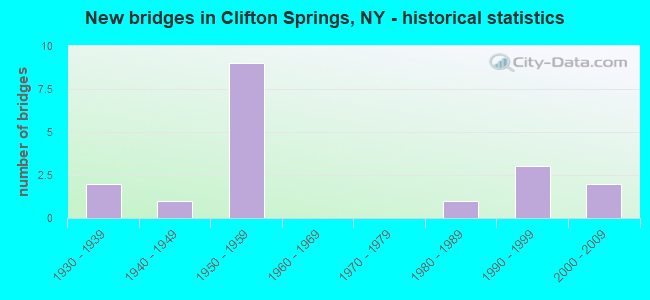
- New bridges - historical statistics
- 21930-1939
- 11940-1949
- 91950-1959
- 11980-1989
- 31990-1999
- 22000-2009

- Reconstructed bridges - Historical Statistics
- 21970-1979
- 41980-1989
- 11990-1999


- Bridge Condition - Deck
- 20.0%Very good
- 33.3%Good
- 20.0%Satisfactory
- 26.7%Poor

- Bridge Condition - Superstructure
- 20.0%Very good
- 46.7%Good
- 13.3%Satisfactory
- 20.0%Fair

- Bridge Condition - Substructure
- 20.0%Very good
- 33.3%Good
- 33.3%Satisfactory
- 13.3%Fair

- Bridge Condition - Channel
- 8.3%Very good
- 50.0%Good
- 33.3%Satisfactory
- 8.3%Fair
Find on map >> Show street view
Structure Number: 103511, Location: 3.6 MI E JCT RTS 96 & 21 (Lat: 42.970597, Lng: -77.158217), Route carried "on" structure: State highway 96, Year Built: 1995, Status: Open, Structure Length: 1.98m (6.50ft), Average Daily Traffic: 7,874 (year 2018), Truck Traffic: 9%, Average Future Daily Traffic: 9,565 (year 2040), Design Load: HS 25 or greater, Features Intersected: FALL BROOK
Minimum Vertical Clearance: 30+ m (98+ ft), Kilometerpoint: 17.184, Lanes on structure: 2, Base Highway Network: Yes, Owner: State Highway Agency, Approaching Roadway Width: 10.4m (34.1ft), Skew: 1 degrees, Material/Design: Prestressed concrete, Design/Construction: Box Beam or Girders - Multiple, Number Of Spans In Main Unit: 1, Length of Maximum Span: 18.5m (60.7ft), Curb-To-Curb Width: 10.7m (35.1ft), Out-to-Out Width: 11.3m (37.1ft)
Condition: Deck: Very good, Superstructure: Very good, Substructure: Very good, Channel: Good, Operating Rating: 89.8 metric tons, Method Used To Determine Operating Rating: Load Factor (LF), Inventory Rating: 40.8 metric tons, Method Used To Determine Inventory Rating: Load Factor (LF), Structural Evaluation: Equal to present desirable criteria, Deck Geometry: Meets minimum limits, Waterway Adequacy: High priority of corrective action, Approach Roadway Alignment: Equal to present desirable criteria, Length Of Structure Improvement: 1.98m (6.50ft), Designated Inspection Frequency: Every 24 months, Inspection Date: August 2021, Bridge Improvement Cost: $520,000, Roadway Improvement Cost: $304,000, Total Project Cost: $824,000 ( Estimate for 2021), Deck Structure Type: Concrete Cast-file-Place, Wearing Surface/Protective System: Wearing Surface: Bituminous, Membrane: Other, Deck Protection: Epoxy Coated Reinforcing
Find on map >> Show street view
Structure Number: 331812, Location: 1.4 MI N CLIFTON SPRING (Lat: 42.981553, Lng: -77.129411), Route carried "on" structure: Other road , Year Built: 1958, Year Reconstructed: 1993, Status: Open, Structure Length: 2.68m (8.79ft), Average Daily Traffic: 674 (year 2016), Truck Traffic: 6%, Average Future Daily Traffic: 944 (year 2036), Design Load: HS 25 or greater, Features Intersected: CANANDAIGUA OUTLT, Facility Carried by Structure: MCBURNEY ROAD
Minimum Vertical Clearance: 30+ m (98+ ft), Kilometerpoint: 0.145, Lanes on structure: 2, Owner: County Highway Agency, Approaching Roadway Width: 8.5m (27.9ft), Skew: 3 degrees, Material/Design: Prestressed concrete, Design/Construction: Box Beam or Girders - Multiple, Number Of Spans In Main Unit: 2, Length of Maximum Span: 13.1m (43.0ft), Curb-To-Curb Width: 9.2m (30.2ft), Out-to-Out Width: 9.8m (32.2ft)
Condition: Deck: Good, Superstructure: Good, Substructure: Satisfactory, Channel: Fair, Operating Rating: 62.2 metric tons, Method Used To Determine Operating Rating: Load and Resistance Factor Rating (LRFR) rating reported by rating factor(RF) method using HL-93 loadings, Inventory Rating: 48.0 metric tons, Method Used To Determine Inventory Rating: Load and Resistance Factor Rating (LRFR) rating reported by rating factor(RF) method using HL-93 loadings, Structural Evaluation: Equal to present minimum criteria, Deck Geometry: Equal to present minimum criteria, Waterway Adequacy: Meets minimum limits, Approach Roadway Alignment: Equal to present desirable criteria, Length Of Structure Improvement: 2.68m (8.79ft), Designated Inspection Frequency: Every 24 months, Inspection Date: July 2020, Bridge Improvement Cost: $905,000, Roadway Improvement Cost: $530,000, Total Project Cost: $1,435,000 ( Estimate for 2021), Wearing Surface/Protective System: Wearing Surface: Bituminous, Membrane: Other
Find on map >> Show street view
Structure Number: 331813, Location: 0.2 MI W CLIFTON SPRINGS (Lat: 42.963408, Lng: -77.152961), Route carried "on" structure: Other road , Year Built: 1935, Year Reconstructed: 1989, Status: Open, Structure Length: 0.98m (3.22ft), Average Daily Traffic: 461 (year 2016), Truck Traffic: 2%, Average Future Daily Traffic: 645 (year 2036), Design Load: HS 20, Features Intersected: ROCKY RUN, Facility Carried by Structure: STEVENS STREET
Minimum Vertical Clearance: 30+ m (98+ ft), Kilometerpoint: 2.381, Lanes on structure: 2, Owner: County Highway Agency, Approaching Roadway Width: 6.7m (22.0ft), Skew: 1 degrees, Material/Design: Steel, Design/Construction: Stringer/Multi-beam, Number Of Spans In Main Unit: 1, Length of Maximum Span: 9.1m (29.9ft), Curb-To-Curb Width: 6.7m (22.0ft), Out-to-Out Width: 7.4m (24.3ft)
Condition: Deck: Very good, Superstructure: Good, Substructure: Good, Channel: Good, Operating Rating: 82.6 metric tons, Method Used To Determine Operating Rating: Load Factor (LF), Inventory Rating: 55.3 metric tons, Method Used To Determine Inventory Rating: Load Factor (LF), Structural Evaluation: Better than present minimum criteria, Deck Geometry: Meets minimum limits, Waterway Adequacy: Equal to present desirable criteria, Approach Roadway Alignment: Equal to present desirable criteria, Length Of Structure Improvement: 0.97m (3.18ft), Designated Inspection Frequency: Every 24 months, Inspection Date: May 2020, Bridge Improvement Cost: $348,000, Roadway Improvement Cost: $204,000, Total Project Cost: $551,000 ( Estimate for 2021), Deck Structure Type: Wood or Timber, Wearing Surface/Protective System: Wearing Surface: Bituminous, Membrane: Other
Find on map >> Show street view
Structure Number: 331839, Location: 1 1/2 MI NE OF ORLEANS (Lat: 42.938597, Lng: -77.100275), Route carried "on" structure: Other road , Year Built: 1947, Year Reconstructed: 1995, Status: Open, Structure Length: 1.98m (6.50ft), Average Daily Traffic: 567 (year 2020), Truck Traffic: 5%, Average Future Daily Traffic: 794 (year 2040), Design Load: HS 25 or greater, Features Intersected: FLINT CREEK, Facility Carried by Structure: WHEAT ROAD
Minimum Vertical Clearance: 30+ m (98+ ft), Kilometerpoint: 2.639, Lanes on structure: 2, Owner: County Highway Agency, Approaching Roadway Width: 5.8m (19.0ft), Skew: 3 degrees, Material/Design: Steel, Design/Construction: Stringer/Multi-beam, Number Of Spans In Main Unit: 1, Length of Maximum Span: 19.2m (63.0ft), Curb-To-Curb Width: 9.1m (29.9ft), Out-to-Out Width: 9.8m (32.2ft)
Condition: Deck: Good, Superstructure: Good, Substructure: Satisfactory, Channel: Good, Operating Rating: 78.0 metric tons, Method Used To Determine Operating Rating: Load Factor (LF), Inventory Rating: 38.1 metric tons, Method Used To Determine Inventory Rating: Load Factor (LF), Structural Evaluation: Equal to present minimum criteria, Deck Geometry: Equal to present minimum criteria, Waterway Adequacy: Equal to present desirable criteria, Approach Roadway Alignment: Equal to present minimum criteria, Length Of Structure Improvement: 1.98m (6.50ft), Designated Inspection Frequency: Every 24 months, Inspection Date: November 2020, Bridge Improvement Cost: $706,000, Roadway Improvement Cost: $414,000, Total Project Cost: $1,120,000 ( Estimate for 2021), Deck Structure Type: Concrete Cast-file-Place, Wearing Surface/Protective System: Wearing Surface: Bituminous
Find on map >> Show street view
Structure Number: 331853, Location: 3.4 MI SE OF MANCHESTER (Lat: 42.944878, Lng: -77.174469), Route carried "on" structure: Other road , Year Built: 2006, Status: Open, Structure Length: 1.31m (4.30ft), Average Daily Traffic: 700 (year 2016), Truck Traffic: 5%, Average Future Daily Traffic: 980 (year 2036), Design Load: HS 25 or greater, Features Intersected: SPRING BROOK, Facility Carried by Structure: TOWN LINE ROAD
Minimum Vertical Clearance: 30+ m (98+ ft), Kilometerpoint: 0.917, Lanes on structure: 2, Owner: County Highway Agency, Approaching Roadway Width: 9.8m (32.2ft), Material/Design: Concrete, Design/Construction: Frame, Number Of Spans In Main Unit: 1, Length of Maximum Span: 12.2m (40.0ft), Curb-To-Curb Width: 9.8m (32.2ft), Out-to-Out Width: 10.8m (35.4ft)
Condition: Deck: Satisfactory, Superstructure: Satisfactory, Substructure: Good, Channel: Good, Operating Rating: 81.3 metric tons, Method Used To Determine Operating Rating: Field evaluation and documented engineering judgment, Inventory Rating: 40.8 metric tons, Method Used To Determine Inventory Rating: Field evaluation and documented engineering judgment, Structural Evaluation: Equal to present minimum criteria, Deck Geometry: Equal to present minimum criteria, Waterway Adequacy: Better than present minimum criteria, Approach Roadway Alignment: Equal to present desirable criteria, Length Of Structure Improvement: 1.31m (4.30ft), Designated Inspection Frequency: Every 24 months, Inspection Date: April 2021, Bridge Improvement Cost: $348,000, Roadway Improvement Cost: $204,000, Total Project Cost: $552,000 ( Estimate for 2021), Wearing Surface/Protective System: Wearing Surface: Bituminous
Find on map >> Show street view
Structure Number: 331864, Location: 1 MI W OF CLIFTON SPRINGS (Lat: 42.967664, Lng: -77.157542), Route carried "on" structure: Other road , Year Built: 1998, Status: Open, Structure Length: 1.04m (3.41ft), Average Daily Traffic: 289 (year 2020), Truck Traffic: 2%, Average Future Daily Traffic: 405 (year 2040), Design Load: HS 25 or greater, Features Intersected: ROCKY RUN, Facility Carried by Structure: KING ROAD
Minimum Vertical Clearance: 30+ m (98+ ft), Kilometerpoint: 0.483, Lanes on structure: 2, Owner: County Highway Agency, Approaching Roadway Width: 9.8m (32.2ft), Skew: 3 degrees, Material/Design: Concrete, Design/Construction: Frame, Number Of Spans In Main Unit: 1, Length of Maximum Span: 10.0m (32.8ft), Curb-To-Curb Width: 9.8m (32.2ft), Out-to-Out Width: 10.7m (35.1ft)
Condition: Deck: Good, Superstructure: Good, Substructure: Very good, Channel: Satisfactory, Operating Rating: 79.7 metric tons, Method Used To Determine Operating Rating: Field evaluation and documented engineering judgment, Inventory Rating: 40.8 metric tons, Method Used To Determine Inventory Rating: Field evaluation and documented engineering judgment, Structural Evaluation: Better than present minimum criteria, Deck Geometry: Better than present minimum criteria, Waterway Adequacy: Equal to present desirable criteria, Approach Roadway Alignment: Somewhat better than minimum adequacy, Length Of Structure Improvement: 1.03m (3.38ft), Designated Inspection Frequency: Every 24 months, Inspection Date: November 2020, Bridge Improvement Cost: $606,000, Roadway Improvement Cost: $355,000, Total Project Cost: $960,000 ( Estimate for 2021)
Find on map >> Show street view
Structure Number: 331869, Location: 2.8 MI.NE OF MANCHESTER (Lat: 42.980792, Lng: -77.179125), Route carried "on" structure: County highway , Year Built: 1939, Year Reconstructed: 1989, Status: Open, Structure Length: 3.84m (12.60ft), Average Daily Traffic: 2,919 (year 2017), Truck Traffic: 13%, Average Future Daily Traffic: 4,087 (year 2037), Design Load: HS 20, Features Intersected: CANANDAIGUA OUTLT, Facility Carried by Structure: PORT GIBSON RD
Minimum Vertical Clearance: 30+ m (98+ ft), Kilometerpoint: 2.156, Lanes on structure: 2, Owner: County Highway Agency, Approaching Roadway Width: 9.1m (29.9ft), Skew: 4 degrees, Material/Design: Steel, Design/Construction: Stringer/Multi-beam, Number Of Spans In Main Unit: 2, Length of Maximum Span: 17.9m (58.7ft), Curb-To-Curb Width: 10.4m (34.1ft), Out-to-Out Width: 11.0m (36.1ft)
Condition: Deck: Good, Superstructure: Good, Substructure: Good, Channel: Satisfactory, Operating Rating: 80.7 metric tons, Method Used To Determine Operating Rating: Load and Resistance Factor Rating (LRFR) rating reported by rating factor(RF) method using HL-93 loadings, Inventory Rating: 61.9 metric tons, Method Used To Determine Inventory Rating: Load and Resistance Factor Rating (LRFR) rating reported by rating factor(RF) method using HL-93 loadings, Structural Evaluation: Better than present minimum criteria, Deck Geometry: Somewhat better than minimum adequacy, Waterway Adequacy: Equal to present desirable criteria, Approach Roadway Alignment: Equal to present desirable criteria, Length Of Structure Improvement: 3.84m (12.60ft), Designated Inspection Frequency: Every 24 months, Inspection Date: June 2020, Bridge Improvement Cost: $1,211,000, Roadway Improvement Cost: $709,000, Total Project Cost: $1,920,000 ( Estimate for 2021), Deck Structure Type: Concrete Cast-file-Place, Wearing Surface/Protective System: Wearing Surface: Bituminous, Deck Protection: Epoxy Coated Reinforcing
Find on map >> Show street view
Structure Number: 33187, Location: 4 MI E OF MANCHESTER (Lat: 42.960089, Lng: -77.154281), Route carried "on" structure: County highway , Year Built: 2000, Status: Open, Structure Length: 1.10m (3.61ft), Average Daily Traffic: 2,449 (year 2016), Truck Traffic: 5%, Average Future Daily Traffic: 3,429 (year 2036), Design Load: HS 25 or greater, Features Intersected: SPRING BROOK, Facility Carried by Structure: COUNTY ROAD 13
Minimum Vertical Clearance: 30+ m (98+ ft), Kilometerpoint: 4.843, Lanes on structure: 2, Owner: County Highway Agency, Approaching Roadway Width: 10.4m (34.1ft), Material/Design: Concrete, Design/Construction: Frame, Number Of Spans In Main Unit: 1, Length of Maximum Span: 10.3m (33.8ft), Curb-To-Curb Width: 11.4m (37.4ft), Out-to-Out Width: 12.3m (40.4ft)
Condition: Deck: Very good, Superstructure: Very good, Substructure: Good, Channel: Very good, Operating Rating: 72.6 metric tons, Method Used To Determine Operating Rating: Load Factor (LF), Inventory Rating: 41.7 metric tons, Method Used To Determine Inventory Rating: Load Factor (LF), Structural Evaluation: Better than present minimum criteria, Deck Geometry: Somewhat better than minimum adequacy, Waterway Adequacy: Equal to present desirable criteria, Approach Roadway Alignment: Equal to present desirable criteria, Length Of Structure Improvement: 1.09m (3.58ft), Designated Inspection Frequency: Every 24 months, Inspection Date: November 2020, Bridge Improvement Cost: $389,000, Roadway Improvement Cost: $228,000, Total Project Cost: $617,000 ( Estimate for 2021), Wearing Surface/Protective System: Wearing Surface: Bituminous
Find on map >> Show street view
Structure Number: 331874, Location: 1.0 MI. N. OF CLIFTON (Lat: 42.975361, Lng: -77.141278), Route carried "on" structure: County highway , Year Built: 1989, Status: Open, Structure Length: 4.60m (15.09ft), Average Daily Traffic: 5,156 (year 2020), Truck Traffic: 5%, Average Future Daily Traffic: 7,218 (year 2040), Design Load: HS 20, Features Intersected: CANANDAIGUA OUTLET, Facility Carried by Structure: FIVE WATERS CLIFTO
Minimum Vertical Clearance: 30+ m (98+ ft), Kilometerpoint: 0.547, Lanes on structure: 2, Owner: County Highway Agency, Approaching Roadway Width: 10.4m (34.1ft), Skew: 3 degrees, Material/Design: Steel, Design/Construction: Stringer/Multi-beam, Number Of Spans In Main Unit: 2, Length of Maximum Span: 22.3m (73.2ft), Curb-To-Curb Width: 10.4m (34.1ft), Out-to-Out Width: 11.0m (36.1ft)
Condition: Deck: Satisfactory, Superstructure: Very good, Substructure: Satisfactory, Channel: Satisfactory, Operating Rating: 78.1 metric tons, Method Used To Determine Operating Rating: Load and Resistance Factor Rating (LRFR) rating reported by rating factor(RF) method using HL-93 loadings, Inventory Rating: 59.9 metric tons, Method Used To Determine Inventory Rating: Load and Resistance Factor Rating (LRFR) rating reported by rating factor(RF) method using HL-93 loadings, Structural Evaluation: Equal to present minimum criteria, Deck Geometry: Meets minimum limits, Waterway Adequacy: Better than present minimum criteria, Approach Roadway Alignment: Equal to present desirable criteria, Length Of Structure Improvement: 4.60m (15.09ft), Designated Inspection Frequency: Every 24 months, Inspection Date: June 2020, Bridge Improvement Cost: $1,251,000, Roadway Improvement Cost: $733,000, Total Project Cost: $1,984,000 ( Estimate for 2021), Deck Structure Type: Concrete Cast-file-Place, Wearing Surface/Protective System: Wearing Surface: Integral Concrete, Deck Protection: Epoxy Coated Reinforcing
Find on map >> Show street view
Structure Number: 331879, Location: HAMLET OF ORLEANS (Lat: 42.917594, Lng: -77.111967), Route carried "on" structure: County highway , Year Built: 1991, Status: Open, Structure Length: 5.46m (17.91ft), Average Daily Traffic: 1,643 (year 2017), Truck Traffic: 8%, Average Future Daily Traffic: 2,300 (year 2037), Design Load: HS 20, Features Intersected: FLINT CREEK, Facility Carried by Structure: COUNTY ROAD 23
Minimum Vertical Clearance: 30+ m (98+ ft), Kilometerpoint: 0.451, Lanes on structure: 2, Owner: County Highway Agency, Approaching Roadway Width: 9.8m (32.2ft), Material/Design: Steel, Design/Construction: Stringer/Multi-beam, Number Of Spans In Main Unit: 1, Length of Maximum Span: 53.0m (173.9ft), Curb-To-Curb Width: 9.8m (32.2ft), Out-to-Out Width: 10.4m (34.1ft)
Condition: Deck: Good, Superstructure: Satisfactory, Substructure: Satisfactory, Channel: Satisfactory, Operating Rating: 89.8 metric tons, Method Used To Determine Operating Rating: Load Factor (LF), Inventory Rating: 32.7 metric tons, Method Used To Determine Inventory Rating: Load Factor (LF), Structural Evaluation: Equal to present minimum criteria, Deck Geometry: Somewhat better than minimum adequacy, Waterway Adequacy: Somewhat better than minimum adequacy, Approach Roadway Alignment: Equal to present desirable criteria, Length Of Structure Improvement: 5.45m (17.88ft), Designated Inspection Frequency: Every 24 months, Inspection Date: June 2020, Bridge Improvement Cost: $1,541,000, Roadway Improvement Cost: $902,000, Total Project Cost: $2,443,000 ( Estimate for 2021), Deck Structure Type: Concrete Cast-file-Place, Wearing Surface/Protective System: Wearing Surface: Integral Concrete, Deck Protection: Epoxy Coated Reinforcing
Find on map >> Show street view
Structure Number: 5510811, Location: 3.9 MI E OF EXIT 43 90I (Lat: 42.973486, Lng: -77.157819), Route carried "on" structure: Interstate 90, Year Built: 1954, Status: Open, Structure Length: 1.55m (5.09ft), Average Daily Traffic: 18,825 (year 2014), Truck Traffic: 18%, Design Load: HS 20+Mod, Features Intersected: FALL BROOK
Minimum Vertical Clearance: 30+ m (98+ ft), Kilometerpoint: 541.348, Lanes on structure: 2, Base Highway Network: Yes, Toll: On Interstate toll segment, Owner: State Toll Authority, Approaching Roadway Width: 11.9m (39.0ft), Material/Design: Steel, Design/Construction: Stringer/Multi-beam, Number Of Spans In Main Unit: 1, Length of Maximum Span: 14.3m (46.9ft), Curb or Sidewalk Widths: Left: 0.0m, Right: 0.7m (2.3ft), Curb-To-Curb Width: 14.9m (48.9ft), Out-to-Out Width: 17.1m (56.1ft)
Condition: Deck: Poor, Superstructure: Fair, Substructure: Satisfactory, Channel: Good, Operating Rating: 30.8 metric tons, Method Used To Determine Operating Rating: Load Factor (LF), Inventory Rating: 18.1 metric tons, Method Used To Determine Inventory Rating: Load Factor (LF), Structural Evaluation: Meets minimum limits, Deck Geometry: Superior to present desirable criteria, Waterway Adequacy: Superior to present desirable criteria, Approach Roadway Alignment: Equal to present desirable criteria, Length Of Structure Improvement: 1.55m (5.09ft), Designated Inspection Frequency: Every 24 months, Inspection Date: May 2021, Bridge Improvement Cost: $1,078,000, Roadway Improvement Cost: $631,000, Total Project Cost: $1,709,000 ( Estimate for 2021), Deck Structure Type: Concrete Cast-file-Place, Wearing Surface/Protective System: Wearing Surface: Bituminous, Membrane: Other
Find on map >> Show street view
Structure Number: 5510812, Location: 3.9 MI E OF EXIT 43 90I (Lat: 42.972950, Lng: -77.157833), Route carried "on" structure: Interstate 90, Year Built: 1954, Status: Open, Structure Length: 1.55m (5.09ft), Average Daily Traffic: 13,793 (year 2020), Truck Traffic: 28%, Average Future Daily Traffic: 19,182 (year 2040), Design Load: HS 20+Mod, Features Intersected: FALL BROOK
Minimum Vertical Clearance: 30+ m (98+ ft), Kilometerpoint: 27.466, Lanes on structure: 2, Base Highway Network: Yes, Toll: On Interstate toll segment, Owner: State Toll Authority, Approaching Roadway Width: 11.9m (39.0ft), Material/Design: Steel, Design/Construction: Stringer/Multi-beam, Number Of Spans In Main Unit: 1, Length of Maximum Span: 14.3m (46.9ft), Curb-To-Curb Width: 16.2m (53.1ft), Out-to-Out Width: 17.1m (56.1ft)
Condition: Deck: Poor, Superstructure: Fair, Substructure: Fair, Channel: Good, Operating Rating: 45.4 metric tons, Method Used To Determine Operating Rating: Load Factor (LF), Inventory Rating: 27.2 metric tons, Method Used To Determine Inventory Rating: Load Factor (LF), Structural Evaluation: Somewhat better than minimum adequacy, Deck Geometry: Superior to present desirable criteria, Waterway Adequacy: Superior to present desirable criteria, Approach Roadway Alignment: Equal to present desirable criteria, Length Of Structure Improvement: 1.55m (5.09ft), Designated Inspection Frequency: Every 24 months, Inspection Date: May 2021, Bridge Improvement Cost: $991,000, Roadway Improvement Cost: $580,000, Total Project Cost: $1,571,000 ( Estimate for 2021), Deck Structure Type: Concrete Cast-file-Place, Wearing Surface/Protective System: Wearing Surface: Bituminous, Membrane: Other
Find on map >> Show street view
Structure Number: 551096, Location: 2.7 MI E OF EXIT 43 90I (Lat: 42.973536, Lng: -77.180369), Route carried "on" structure: County highway , Year Built: 1953, Year Reconstructed: 1976, Status: Open, Structure Length: 4.42m (14.50ft), Average Daily Traffic: 2,919 (year 2017), Truck Traffic: 13%, Average Future Daily Traffic: 3,611 (year 2040), Design Load: HS 20+Mod, Features Intersected: 90IX EB, Facility Carried by Structure: CR 7 PORT GIBSON
Minimum Vertical Clearance: 30+ m (98+ ft), Kilometerpoint: 1.352, Lanes on structure: 2, Lanes under structure: 2, Owner: State Toll Authority, Approaching Roadway Width: 9.8m (32.2ft), Material/Design: Steel, Design/Construction: Stringer/Multi-beam, Number Of Spans In Main Unit: 3, Length of Maximum Span: 18.3m (60.0ft), Curb-To-Curb Width: 9.1m (29.9ft), Out-to-Out Width: 10.1m (33.1ft)
Condition: Deck: Poor, Superstructure: Fair, Substructure: Fair, Operating Rating: 71.7 metric tons, Method Used To Determine Operating Rating: Load Factor (LF), Inventory Rating: 42.6 metric tons, Method Used To Determine Inventory Rating: Load Factor (LF), Structural Evaluation: Somewhat better than minimum adequacy, Deck Geometry: Meets minimum limits, Underclear: High priority of corrective action, Approach Roadway Alignment: Equal to present desirable criteria, Length Of Structure Improvement: 4.41m (14.47ft), Designated Inspection Frequency: Every 24 months, Inspection Date: September 2021, Bridge Improvement Cost: $1,060,000, Roadway Improvement Cost: $621,000, Total Project Cost: $1,680,000 ( Estimate for 2021), Deck Structure Type: Concrete Cast-file-Place, Wearing Surface/Protective System: Wearing Surface: Integral Concrete
Find on map >> Show street view
Structure Number: 551097, Location: 4.7 MI E OF EXIT 43 90I (Lat: 42.972992, Lng: -77.140631), Route carried "on" structure: County highway , Year Built: 1953, Year Reconstructed: 1991, Status: Open, Structure Length: 9.08m (29.79ft), Average Daily Traffic: 5,156 (year 2020), Truck Traffic: 5%, Average Future Daily Traffic: 6,379 (year 2040), Design Load: HS 20+Mod, Features Intersected: 90IX EB, RTE I90, Facility Carried by Structure: CR 25 KENDALL RD
Minimum Vertical Clearance: 30+ m (98+ ft), Kilometerpoint: 0.306, Lanes on structure: 2, Lanes under structure: 4, Owner: State Toll Authority, Approaching Roadway Width: 9.4m (30.8ft), Material/Design: Steel, Design/Construction: Stringer/Multi-beam, Number Of Spans In Main Unit: 5, Length of Maximum Span: 20.7m (67.9ft), Curb-To-Curb Width: 9.4m (30.8ft), Out-to-Out Width: 10.1m (33.1ft)
Condition: Deck: Satisfactory, Superstructure: Good, Substructure: Good, Operating Rating: 57.2 metric tons, Method Used To Determine Operating Rating: Load Factor (LF), Inventory Rating: 34.5 metric tons, Method Used To Determine Inventory Rating: Load Factor (LF), Structural Evaluation: Better than present minimum criteria, Deck Geometry: Meets minimum limits, Underclear: High priority of corrective action, Approach Roadway Alignment: Equal to present desirable criteria, Length Of Structure Improvement: 9.08m (29.79ft), Designated Inspection Frequency: Every 24 months, Inspection Date: September 2020, Bridge Improvement Cost: $2,069,000, Roadway Improvement Cost: $1,211,000, Total Project Cost: $3,280,000 ( Estimate for 2021), Deck Structure Type: Concrete Cast-file-Place, Wearing Surface/Protective System: Wearing Surface: Integral Concrete, Deck Protection: Epoxy Coated Reinforcing
Find on map >> Show street view
Structure Number: 5511, Location: 2.7 MI E OF EXIT 43 90I (Lat: 42.974369, Lng: -77.180197), Route carried "on" structure: County highway , Year Built: 1954, Year Reconstructed: 1976, Status: Open, Structure Length: 4.42m (14.50ft), Average Daily Traffic: 2,919 (year 2017), Truck Traffic: 13%, Average Future Daily Traffic: 3,045 (year 2040), Design Load: HS 20+Mod, Features Intersected: RTE I90, Facility Carried by Structure: CR 7 PORT GIBSON
Minimum Vertical Clearance: 30+ m (98+ ft), Kilometerpoint: 1.448, Lanes on structure: 2, Lanes under structure: 2, Owner: State Toll Authority, Approaching Roadway Width: 9.8m (32.2ft), Material/Design: Steel, Design/Construction: Stringer/Multi-beam, Number Of Spans In Main Unit: 3, Length of Maximum Span: 18.3m (60.0ft), Curb-To-Curb Width: 9.1m (29.9ft), Out-to-Out Width: 10.1m (33.1ft)
Condition: Deck: Poor, Superstructure: Good, Substructure: Very good, Operating Rating: 80.7 metric tons, Method Used To Determine Operating Rating: Load Factor (LF), Inventory Rating: 48.1 metric tons, Method Used To Determine Inventory Rating: Load Factor (LF), Structural Evaluation: Better than present minimum criteria, Deck Geometry: Meets minimum limits, Underclear: High priority of corrective action, Approach Roadway Alignment: Equal to present desirable criteria, Length Of Structure Improvement: 4.41m (14.47ft), Designated Inspection Frequency: Every 24 months, Inspection Date: September 2021, Bridge Improvement Cost: $1,059,000, Roadway Improvement Cost: $620,000, Total Project Cost: $1,679,000 ( Estimate for 2021), Deck Structure Type: Concrete Cast-file-Place, Wearing Surface/Protective System: Wearing Surface: Integral Concrete
Find on map >> Show street view
Structure Number: 551096, Location: 2.7 MI E OF EXIT 43 90I (Lat: 42.973536, Lng: -77.180369), Route carried "under" structure: Interstate , Year Built: 1953, Structure Length: 0. m, Average Daily Traffic: 17,666 (year 1977), Features Intersected: 90IX EB, Facility Carried by Structure: CR 7 PORT GIBSON
Minimum Vertical Clearance: 4.65m (15.26ft), Kilometerpoint: 542.989, Lanes on structure: 2, Lanes under structure: 2, Toll: On Interstate toll segment, Material/Design: Steel, Design/Construction: Stringer/Multi-beam, Length of Maximum Span: 18.3m (60.0ft)
Find on map >> Show street view
Structure Number: 551097, Location: 4.7 MI E OF EXIT 43 90I (Lat: 42.972992, Lng: -77.140631), Route carried "under" structure: Interstate 90, Year Built: 1953, Structure Length: 0. m, Average Daily Traffic: 17,666 (year 1977), Features Intersected: 90IX EB, RTE I90, Facility Carried by Structure: CR 25 KENDALL RD
Minimum Vertical Clearance: 4.55m (14.93ft), Kilometerpoint: 539.739, Lanes on structure: 2, Lanes under structure: 2, Toll: On Interstate toll segment, Material/Design: Steel, Design/Construction: Stringer/Multi-beam, Length of Maximum Span: 20.7m (67.9ft)
Find on map >> Show street view
Structure Number: 5511, Location: 2.7 MI E OF EXIT 43 90I (Lat: 42.974369, Lng: -77.180197), Route carried "under" structure: Interstate 90, Year Built: 1954, Structure Length: 0. m, Average Daily Traffic: 17,666 (year 1977), Features Intersected: RTE I90, Facility Carried by Structure: CR 7 PORT GIBSON
Minimum Vertical Clearance: 4.72m (15.49ft), Kilometerpoint: 543.005, Lanes on structure: 2, Lanes under structure: 2, Toll: On Interstate toll segment, Material/Design: Steel, Design/Construction: Stringer/Multi-beam, Length of Maximum Span: 18.3m (60.0ft)