Bridge Statistics for Clyde, Kansas (KS)
Condition, Traffic, Stress, Structural Evaluation, Project Costs
- National Bridge Inventory (NBI) Statistics
- 22Number of bridges
- 230ft / 69.8mTotal length
- $2,850,000Total costs
- 8,782Total average daily traffic
- 577Total average daily truck traffic
- 10,084Total future (year 2039) average daily traffic
- National Bridge Inventory (NBI) Registered Bridges for Clyde
- No street view available for this location
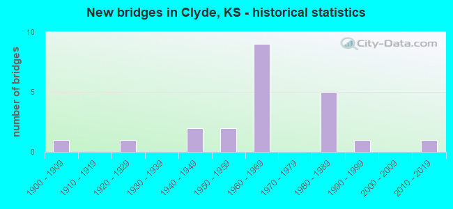
- New bridges - historical statistics
- 11900-1909
- 11920-1929
- 21940-1949
- 21950-1959
- 91960-1969
- 51980-1989
- 11990-1999
- 12010-2019

- Reconstructed bridges - Historical Statistics
- 11970-1979
- 01980-1989
- 11990-1999

- Bridge Condition - Deck
- 38.9%Very good
- 44.4%Good
- 11.1%Satisfactory
- 5.6%Fair

- Bridge Condition - Superstructure
- 33.3%Very good
- 44.4%Good
- 16.7%Satisfactory
- 5.6%Fair

- Bridge Condition - Substructure
- 33.3%Very good
- 44.4%Good
- 11.1%Satisfactory
- 11.1%Fair

- Bridge Condition - Channel
- 40.9%Very good
- 27.3%Good
- 31.8%Satisfactory

- Bridge Condition - Culverts
- 75.0%Good
- 25.0%Satisfactory
Find on map >> Show street view
Structure Number: 15027, Location: 1.4N OF CLYDE (Lat: 39.616750, Lng: -97.406164), Route carried "on" structure: County highway 144, Year Built: 1968, Status: Open, Structure Length: 4.36m (14.30ft), Average Daily Traffic: 525 (year 2019), Truck Traffic: 10%, Average Future Daily Traffic: 543 (year 2043), Design Load: HS 20, Features Intersected: ELK CREEK
Minimum Vertical Clearance: 30.47m (99.97ft), Kilometerpoint: 0.000, Lanes on structure: 2, Owner: County Highway Agency, Approaching Roadway Width: 9.8m (32.2ft), Skew: 2 degrees, Material/Design: Concrete continuous, Design/Construction: Slab, Number Of Spans In Main Unit: 3, Length of Maximum Span: 17.1m (56.1ft), Curb-To-Curb Width: 8.5m (27.9ft), Out-to-Out Width: 9.7m (31.8ft)
Condition: Deck: Good, Superstructure: Good, Substructure: Good, Channel: Very good, Operating Rating: 51.7 metric tons, Method Used To Determine Operating Rating: Load Factor (LF), Inventory Rating: 30.9 metric tons, Method Used To Determine Inventory Rating: Load Factor (LF), Structural Evaluation: Better than present minimum criteria, Deck Geometry: Somewhat better than minimum adequacy, Waterway Adequacy: Equal to present desirable criteria, Approach Roadway Alignment: Equal to present desirable criteria, Designated Inspection Frequency: Every 24 months, Inspection Date: December 2020, Deck Structure Type: Concrete Cast-file-Place, Wearing Surface/Protective System: Wearing Surface: Bituminous
Find on map >> Show street view
Structure Number: 15035, Location: 0.9W 2.8N OF AMES (Lat: 39.610083, Lng: -97.462067), Route carried "on" structure: County highway 146, Year Built: 1948, Status: Posted for load, Structure Length: 1.83m (6.00ft), Average Daily Traffic: 250 (year 2019), Truck Traffic: 10%, Average Future Daily Traffic: 270 (year 2043), Design Load: H 15, Features Intersected: CREEK
Minimum Vertical Clearance: 30.47m (99.97ft), Kilometerpoint: 0.000, Lanes on structure: 2, Owner: County Highway Agency, Approaching Roadway Width: 7.8m (25.6ft), Material/Design: Steel continuous, Design/Construction: Stringer/Multi-beam, Number Of Spans In Main Unit: 3, Length of Maximum Span: 7.3m (24.0ft), Curb-To-Curb Width: 7.3m (24.0ft), Out-to-Out Width: 7.8m (25.6ft)
Condition: Deck: Very good, Superstructure: Good, Substructure: Good, Channel: Very good, Operating Rating: 28.8 metric tons, Method Used To Determine Operating Rating: Load Factor (LF), Inventory Rating: 17.1 metric tons, Method Used To Determine Inventory Rating: Load Factor (LF), Structural Evaluation: Somewhat better than minimum adequacy, Deck Geometry: Somewhat better than minimum adequacy, Waterway Adequacy: Equal to present desirable criteria, Approach Roadway Alignment: Equal to present desirable criteria, Bridge Posting: Required (Relationship of Operating Rating to Maximum Legal Load: 0.1 - 9.9% below), Length Of Structure Improvement: 1.83m (6.00ft), Designated Inspection Frequency: Every 24 months, Inspection Date: December 2020, Bridge Improvement Cost: $180,000, Roadway Improvement Cost: $50,000, Total Project Cost: $235,000 ( Estimate for 2019), Deck Structure Type: Concrete Cast-file-Place, Wearing Surface/Protective System: Wearing Surface: Bituminous
Find on map >> Show street view
Structure Number: 15047, Location: 1.8N OF ST. JOSEPH (Lat: 39.533939, Lng: -97.406392), Route carried "on" structure: County highway 1047, Year Built: 1969, Status: Open, Structure Length: 1.34m (4.40ft), Average Daily Traffic: 142 (year 2019), Truck Traffic: 5%, Average Future Daily Traffic: 235 (year 2043), Design Load: H 15, Features Intersected: BEAVER CREEK
Minimum Vertical Clearance: 30.47m (99.97ft), Kilometerpoint: 0.000, Lanes on structure: 2, Owner: County Highway Agency, Approaching Roadway Width: 9.8m (32.2ft), Material/Design: Concrete, Design/Construction: Culvert, Number Of Spans In Main Unit: 4, Length of Maximum Span: 3.0m (9.8ft), Curb-To-Curb Width: 9.8m (32.2ft), Out-to-Out Width: 13.6m (44.6ft)
Condition: Channel: Good, Culverts: Good, Operating Rating: 42.5 metric tons, Method Used To Determine Operating Rating: Load Factor (LF), Inventory Rating: 25.4 metric tons, Method Used To Determine Inventory Rating: Load Factor (LF), Structural Evaluation: Equal to present minimum criteria, Deck Geometry: Better than present minimum criteria, Waterway Adequacy: Better than present minimum criteria, Approach Roadway Alignment: Equal to present desirable criteria, Length Of Structure Improvement: 1.52m (4.99ft), Designated Inspection Frequency: Every 24 months, Inspection Date: March 2021, Bridge Improvement Cost: $210,000, Roadway Improvement Cost: $40,000, Total Project Cost: $255,000 ( Estimate for 2019)
Find on map >> Show street view
Structure Number: 1408176036, Location: 3.0W OF VINING (Lat: 39.566997, Lng: -97.354469), Route carried "on" structure: County highway , Year Built: 1940, Status: Posted for load, Structure Length: 2.19m (7.19ft), Average Daily Traffic: 10 (year 2015), Average Future Daily Traffic: 15 (year 2042), Features Intersected: DRY CREEK, Facility Carried by Structure: LOCAL 1.0-A.6
Minimum Vertical Clearance: 30.47m (99.97ft), Kilometerpoint: 0.000, Lanes on structure: 1, Owner: County Highway Agency, Approaching Roadway Width: 5.4m (17.7ft), Material/Design: Steel, Design/Construction: Stringer/Multi-beam, Number Of Spans In Main Unit: 2, Length of Maximum Span: 11.0m (36.1ft), Curb-To-Curb Width: 4.6m (15.1ft), Out-to-Out Width: 4.9m (16.1ft)
Condition: Deck: Satisfactory, Superstructure: Satisfactory, Substructure: Fair, Channel: Satisfactory, Operating Rating: 11.2 metric tons, Method Used To Determine Operating Rating: Load Factor (LF), Inventory Rating: 6.6 metric tons, Method Used To Determine Inventory Rating: Load Factor (LF), Structural Evaluation: High priority of replacement, Deck Geometry: Better than present minimum criteria, Waterway Adequacy: Equal to present minimum criteria, Approach Roadway Alignment: Equal to present desirable criteria, Bridge Posting: Required (Relationship of Operating Rating to Maximum Legal Load: 30.0 - 39.9% below), Length Of Structure Improvement: 3.65m (11.98ft), Designated Inspection Frequency: Every 24 months, Inspection Date: January 2022, Bridge Improvement Cost: $320,000, Roadway Improvement Cost: $110,000, Total Project Cost: $430,000 ( Estimate for 2016), Deck Structure Type: Wood or Timber, Wearing Surface/Protective System: Wearing Surface: Wood or Timber
Find on map >> Show street view
Structure Number: 150807003567, Location: 3.0W OF CLYDE (Lat: 39.585706, Lng: -97.462536), Route carried "on" structure: County highway , Year Built: 1981, Status: Open, Structure Length: 3.43m (11.25ft), Average Daily Traffic: 60 (year 2019), Truck Traffic: 5%, Average Future Daily Traffic: 60 (year 2043), Design Load: H 20, Features Intersected: ELM CREEK, Facility Carried by Structure: 250th Ave. (5120)
Minimum Vertical Clearance: 30.47m (99.97ft), Kilometerpoint: 0.000, Lanes on structure: 2, Owner: County Highway Agency, Approaching Roadway Width: 7.3m (24.0ft), Material/Design: Concrete continuous, Design/Construction: Slab, Number Of Spans In Main Unit: 3, Length of Maximum Span: 13.4m (44.0ft), Curb-To-Curb Width: 7.9m (25.9ft), Out-to-Out Width: 8.5m (27.9ft)
Condition: Deck: Very good, Superstructure: Very good, Substructure: Very good, Channel: Good, Operating Rating: 56.8 metric tons, Method Used To Determine Operating Rating: Load Factor (LF), Inventory Rating: 33.9 metric tons, Method Used To Determine Inventory Rating: Load Factor (LF), Structural Evaluation: Equal to present desirable criteria, Deck Geometry: Equal to present minimum criteria, Waterway Adequacy: Equal to present desirable criteria, Approach Roadway Alignment: Equal to present desirable criteria, Length Of Structure Improvement: 3.51m (11.52ft), Designated Inspection Frequency: Every 24 months, Inspection Date: December 2020, Bridge Improvement Cost: $270,000, Roadway Improvement Cost: $50,000, Total Project Cost: $330,000 ( Estimate for 2019), Deck Structure Type: Concrete Cast-file-Place, Wearing Surface/Protective System: Wearing Surface: Monolithic Concrete
Find on map >> Show street view
Structure Number: 150811003502, Location: 3.0N 1.4W OF CLYDE (Lat: 39.634314, Lng: -97.425389), Route carried "on" structure: County highway , Year Built: 1988, Status: Open, Structure Length: 3.44m (11.29ft), Average Daily Traffic: 20 (year 2019), Truck Traffic: 5%, Average Future Daily Traffic: 20 (year 2043), Design Load: HS 20, Features Intersected: ELK CREEK, Facility Carried by Structure: 270th Ave. (519)
Minimum Vertical Clearance: 30.47m (99.97ft), Kilometerpoint: 0.000, Lanes on structure: 2, Owner: County Highway Agency, Approaching Roadway Width: 6.0m (19.7ft), Skew: 3 degrees, Material/Design: Concrete continuous, Design/Construction: Slab, Number Of Spans In Main Unit: 3, Length of Maximum Span: 13.4m (44.0ft), Curb-To-Curb Width: 8.0m (26.2ft), Out-to-Out Width: 8.6m (28.2ft)
Condition: Deck: Very good, Superstructure: Very good, Substructure: Very good, Channel: Good, Operating Rating: 72.5 metric tons, Method Used To Determine Operating Rating: Load Factor (LF), Inventory Rating: 43.4 metric tons, Method Used To Determine Inventory Rating: Load Factor (LF), Structural Evaluation: Equal to present desirable criteria, Deck Geometry: Equal to present minimum criteria, Waterway Adequacy: Equal to present desirable criteria, Approach Roadway Alignment: Equal to present desirable criteria, Designated Inspection Frequency: Every 24 months, Inspection Date: December 2020, Deck Structure Type: Concrete Cast-file-Place, Wearing Surface/Protective System: Wearing Surface: Monolithic Concrete
Find on map >> Show street view
Structure Number: 150811003585, Location: 0.2N 1.0E OF AMES (Lat: 39.570267, Lng: -97.425211), Route carried "on" structure: County highway , Year Built: 1963, Status: Posted for load, Structure Length: 0.67m (2.20ft), Average Daily Traffic: 50 (year 2019), Average Future Daily Traffic: 50 (year 2043), Design Load: H 15, Features Intersected: BEAVER CREEK, Facility Carried by Structure: LOCAL RD. (5119)
Minimum Vertical Clearance: 30.47m (99.97ft), Kilometerpoint: 0.000, Lanes on structure: 2, Owner: County Highway Agency, Approaching Roadway Width: 7.3m (24.0ft), Skew: 3 degrees, Material/Design: Steel, Design/Construction: Stringer/Multi-beam, Number Of Spans In Main Unit: 1, Length of Maximum Span: 5.9m (19.4ft), Curb-To-Curb Width: 6.7m (22.0ft), Out-to-Out Width: 7.0m (23.0ft)
Condition: Deck: Good, Superstructure: Good, Substructure: Good, Channel: Very good, Operating Rating: 14.7 metric tons, Method Used To Determine Operating Rating: Load Factor (LF), Inventory Rating: 8.8 metric tons, Method Used To Determine Inventory Rating: Load Factor (LF), Structural Evaluation: High priority of replacement, Deck Geometry: Somewhat better than minimum adequacy, Waterway Adequacy: Equal to present minimum criteria, Approach Roadway Alignment: Equal to present desirable criteria, Bridge Posting: Required (Relationship of Operating Rating to Maximum Legal Load: > 39.9% below), Length Of Structure Improvement: 1.22m (4.00ft), Designated Inspection Frequency: Every 24 months, Inspection Date: December 2020, Bridge Improvement Cost: $180,000, Roadway Improvement Cost: $40,000, Total Project Cost: $225,000 ( Estimate for 2019), Deck Structure Type: Wood or Timber, Wearing Surface/Protective System: Wearing Surface: Wood or Timber
Find on map >> Show street view
Structure Number: 1508111035, Location: 1.0W 3.5N OF CLYDE (Lat: 39.639517, Lng: -97.424392), Route carried "on" structure: County highway , Year Built: 1954, Status: Posted for load, Structure Length: 2.74m (8.99ft), Average Daily Traffic: 30 (year 2019), Average Future Daily Traffic: 30 (year 2043), Design Load: H 15, Features Intersected: ELK CREEK, Facility Carried by Structure: LOCAL RD. (5110)
Minimum Vertical Clearance: 30.47m (99.97ft), Kilometerpoint: 0.000, Lanes on structure: 2, Owner: County Highway Agency, Approaching Roadway Width: 6.7m (22.0ft), Material/Design: Steel continuous, Design/Construction: Stringer/Multi-beam, Number Of Spans In Main Unit: 3, Length of Maximum Span: 10.1m (33.1ft), Curb-To-Curb Width: 6.1m (20.0ft), Out-to-Out Width: 6.6m (21.7ft)
Condition: Deck: Very good, Superstructure: Very good, Substructure: Very good, Channel: Very good, Operating Rating: 20.7 metric tons, Method Used To Determine Operating Rating: Load Factor (LF), Inventory Rating: 12.6 metric tons, Method Used To Determine Inventory Rating: Load Factor (LF), Structural Evaluation: Meets minimum limits, Deck Geometry: Somewhat better than minimum adequacy, Waterway Adequacy: Somewhat better than minimum adequacy, Approach Roadway Alignment: Equal to present desirable criteria, Length Of Structure Improvement: 2.44m (8.01ft), Designated Inspection Frequency: Every 24 months, Inspection Date: December 2020, Bridge Improvement Cost: $200,000, Roadway Improvement Cost: $40,000, Total Project Cost: $250,000 ( Estimate for 2019), Deck Structure Type: Concrete Cast-file-Place
Find on map >> Show street view
Structure Number: 15081140352, Location: 2.0N 0.8W OF CLYDE (Lat: 39.625067, Lng: -97.417539), Route carried "on" structure: County highway , Year Built: 1981, Status: Open, Structure Length: 4.34m (14.24ft), Average Daily Traffic: 40 (year 2019), Average Future Daily Traffic: 50 (year 2043), Design Load: H 15, Features Intersected: ELK CREEK, Facility Carried by Structure: Vale Road (5111)
Minimum Vertical Clearance: 30.47m (99.97ft), Kilometerpoint: 0.000, Lanes on structure: 2, Owner: County Highway Agency, Approaching Roadway Width: 6.0m (19.7ft), Material/Design: Concrete continuous, Design/Construction: Slab, Number Of Spans In Main Unit: 3, Length of Maximum Span: 17.1m (56.1ft), Curb-To-Curb Width: 7.9m (25.9ft), Out-to-Out Width: 8.5m (27.9ft)
Condition: Deck: Very good, Superstructure: Very good, Substructure: Very good, Channel: Very good, Operating Rating: 50.2 metric tons, Method Used To Determine Operating Rating: Load Factor (LF), Inventory Rating: 30.0 metric tons, Method Used To Determine Inventory Rating: Load Factor (LF), Structural Evaluation: Better than present minimum criteria, Deck Geometry: Equal to present minimum criteria, Waterway Adequacy: Better than present minimum criteria, Approach Roadway Alignment: Equal to present desirable criteria, Designated Inspection Frequency: Every 24 months, Inspection Date: December 2020, Deck Structure Type: Concrete Cast-file-Place, Wearing Surface/Protective System: Wearing Surface: Monolithic Concrete
Find on map >> Show street view
Structure Number: 15081310364, Location: 3.5S OF CLYDE (Lat: 39.538792, Lng: -97.405408), Route carried "on" structure: County highway , Year Built: 1966, Status: Posted for load, Structure Length: 1.25m (4.10ft), Average Daily Traffic: 40 (year 2019), Average Future Daily Traffic: 40 (year 2043), Design Load: H 15, Features Intersected: BEAVER CREEK, Facility Carried by Structure: LOCAL RD. (6114)
Minimum Vertical Clearance: 30.47m (99.97ft), Kilometerpoint: 0.000, Lanes on structure: 2, Owner: County Highway Agency, Approaching Roadway Width: 7.8m (25.6ft), Material/Design: Steel, Design/Construction: Stringer/Multi-beam, Number Of Spans In Main Unit: 1, Length of Maximum Span: 11.6m (38.1ft), Curb-To-Curb Width: 7.3m (24.0ft), Out-to-Out Width: 7.9m (25.9ft)
Condition: Deck: Good, Superstructure: Good, Substructure: Satisfactory, Channel: Satisfactory, Operating Rating: 26.0 metric tons, Method Used To Determine Operating Rating: Load Factor (LF), Inventory Rating: 15.6 metric tons, Method Used To Determine Inventory Rating: Load Factor (LF), Structural Evaluation: Meets minimum limits, Deck Geometry: Equal to present minimum criteria, Waterway Adequacy: Better than present minimum criteria, Approach Roadway Alignment: Equal to present desirable criteria, Length Of Structure Improvement: 1.52m (4.99ft), Designated Inspection Frequency: Every 24 months, Inspection Date: March 2021, Bridge Improvement Cost: $150,000, Roadway Improvement Cost: $40,000, Total Project Cost: $200,000 ( Estimate for 2019), Deck Structure Type: Concrete Cast-file-Place, Wearing Surface/Protective System: Wearing Surface: Gravel
Find on map >> Show street view
Structure Number: 15081340362, Location: 1.5S 2.4E OF AMES (Lat: 39.553222, Lng: -97.398614), Route carried "on" structure: County highway , Year Built: 1981, Status: Open, Structure Length: 3.12m (10.24ft), Average Daily Traffic: 50 (year 2019), Average Future Daily Traffic: 50 (year 2043), Design Load: HS 20, Features Intersected: BEAVER CREEK, Facility Carried by Structure: Quail Road (6110)
Minimum Vertical Clearance: 30.47m (99.97ft), Kilometerpoint: 0.000, Lanes on structure: 2, Owner: County Highway Agency, Approaching Roadway Width: 7.9m (25.9ft), Material/Design: Concrete continuous, Design/Construction: Slab, Number Of Spans In Main Unit: 3, Length of Maximum Span: 12.2m (40.0ft), Curb-To-Curb Width: 7.9m (25.9ft), Out-to-Out Width: 8.6m (28.2ft)
Condition: Deck: Very good, Superstructure: Very good, Substructure: Very good, Channel: Very good, Operating Rating: 48.7 metric tons, Method Used To Determine Operating Rating: Load Factor (LF), Inventory Rating: 29.1 metric tons, Method Used To Determine Inventory Rating: Load Factor (LF), Structural Evaluation: Better than present minimum criteria, Deck Geometry: Equal to present minimum criteria, Waterway Adequacy: Better than present minimum criteria, Approach Roadway Alignment: Equal to present desirable criteria, Designated Inspection Frequency: Every 24 months, Inspection Date: March 2021, Deck Structure Type: Concrete Cast-file-Place, Wearing Surface/Protective System: Wearing Surface: Monolithic Concrete
Find on map >> Show street view
Structure Number: 15081360352, Location: 2.5N OF CLYDE (Lat: 39.634833, Lng: -97.394136), Route carried "on" structure: County highway , Year Built: 1900, Status: Open, Structure Length: 0.86m (2.82ft), Average Daily Traffic: 30 (year 2019), Average Future Daily Traffic: 30 (year 2043), Design Load: H 15, Features Intersected: ELK CREEK, Facility Carried by Structure: LOCAL RD. (5112)
Minimum Vertical Clearance: 30.47m (99.97ft), Kilometerpoint: 0.000, Lanes on structure: 2, Owner: County Highway Agency, Approaching Roadway Width: 6.7m (22.0ft), Skew: 1 degrees, Material/Design: Steel, Design/Construction: Stringer/Multi-beam, Number Of Spans In Main Unit: 1, Length of Maximum Span: 7.8m (25.6ft), Curb-To-Curb Width: 5.8m (19.0ft), Out-to-Out Width: 5.9m (19.4ft)
Condition: Deck: Satisfactory, Superstructure: Satisfactory, Substructure: Satisfactory, Channel: Satisfactory, Operating Rating: 40.5 metric tons, Method Used To Determine Operating Rating: Load Factor (LF), Inventory Rating: 24.2 metric tons, Method Used To Determine Inventory Rating: Load Factor (LF), Structural Evaluation: Equal to present minimum criteria, Deck Geometry: Meets minimum limits, Waterway Adequacy: Equal to present minimum criteria, Approach Roadway Alignment: Equal to present desirable criteria, Length Of Structure Improvement: 1.22m (4.00ft), Designated Inspection Frequency: Every 24 months, Inspection Date: December 2020, Bridge Improvement Cost: $180,000, Roadway Improvement Cost: $40,000, Total Project Cost: $225,000 ( Estimate for 2019), Deck Structure Type: Wood or Timber, Wearing Surface/Protective System: Wearing Surface: Gravel
Find on map >> Show street view
Structure Number: 150815203623, Location: 2.8N 1.3E OF ST. JOSEPH (Lat: 39.549253, Lng: -97.383758), Route carried "on" structure: County highway , Year Built: 1983, Status: Open, Structure Length: 0.94m (3.08ft), Average Daily Traffic: 20 (year 2019), Average Future Daily Traffic: 50 (year 2043), Design Load: H 20, Features Intersected: DRY CREEK, Facility Carried by Structure: LOCAL RD. (6111)
Minimum Vertical Clearance: 30.47m (99.97ft), Kilometerpoint: 0.000, Lanes on structure: 2, Owner: County Highway Agency, Approaching Roadway Width: 7.3m (24.0ft), Material/Design: Steel, Design/Construction: Stringer/Multi-beam, Number Of Spans In Main Unit: 1, Length of Maximum Span: 8.5m (27.9ft), Curb-To-Curb Width: 7.4m (24.3ft), Out-to-Out Width: 8.0m (26.2ft)
Condition: Deck: Good, Superstructure: Good, Substructure: Good, Channel: Good, Operating Rating: 34.4 metric tons, Method Used To Determine Operating Rating: Load Factor (LF), Inventory Rating: 20.6 metric tons, Method Used To Determine Inventory Rating: Load Factor (LF), Structural Evaluation: Somewhat better than minimum adequacy, Deck Geometry: Equal to present minimum criteria, Waterway Adequacy: Equal to present desirable criteria, Approach Roadway Alignment: Equal to present desirable criteria, Length Of Structure Improvement: 1.22m (4.00ft), Designated Inspection Frequency: Every 24 months, Inspection Date: March 2021, Bridge Improvement Cost: $185,000, Roadway Improvement Cost: $40,000, Total Project Cost: $230,000 ( Estimate for 2019), Deck Structure Type: Concrete Cast-file-Place
Find on map >> Show street view
Structure Number: 15081520364, Location: 0.2E 2.0N OF ST. JOSEPH (Lat: 39.538411, Lng: -97.384269), Route carried "on" structure: County highway , Year Built: 1965, Year Reconstructed: 1979, Status: Posted for load, Structure Length: 0.89m (2.92ft), Average Daily Traffic: 50 (year 2019), Average Future Daily Traffic: 50 (year 2043), Design Load: H 15, Features Intersected: DRY CREEK, Facility Carried by Structure: LOCAL RD. (6112)
Minimum Vertical Clearance: 30.47m (99.97ft), Kilometerpoint: 0.000, Lanes on structure: 2, Owner: County Highway Agency, Approaching Roadway Width: 6.7m (22.0ft), Material/Design: Steel, Design/Construction: Stringer/Multi-beam, Number Of Spans In Main Unit: 1, Length of Maximum Span: 8.5m (27.9ft), Curb-To-Curb Width: 7.3m (24.0ft), Out-to-Out Width: 7.8m (25.6ft)
Condition: Deck: Good, Superstructure: Good, Substructure: Good, Channel: Satisfactory, Operating Rating: 10.9 metric tons, Method Used To Determine Operating Rating: Load Factor (LF), Inventory Rating: 6.5 metric tons, Method Used To Determine Inventory Rating: Load Factor (LF), Structural Evaluation: High priority of corrective action, Deck Geometry: Equal to present minimum criteria, Waterway Adequacy: Better than present minimum criteria, Approach Roadway Alignment: Equal to present desirable criteria, Bridge Posting: Required (Relationship of Operating Rating to Maximum Legal Load: > 39.9% below), Length Of Structure Improvement: 1.22m (4.00ft), Designated Inspection Frequency: Every 24 months, Inspection Date: March 2021, Bridge Improvement Cost: $185,000, Roadway Improvement Cost: $40,000, Total Project Cost: $230,000 ( Estimate for 2019), Deck Structure Type: Concrete Cast-file-Place
Find on map >> Show street view
Structure Number: 101081770356, Location: 2.0N 3.3W OF VINING (Lat: 39.596081, Lng: -97.355719), Route carried "on" structure: County highway 20, Year Built: 2017, Status: Open, Structure Length: 1.22m (4.00ft), Average Daily Traffic: 20 (year 2014), Average Future Daily Traffic: 30 (year 2039), Design Load: HS 20, Features Intersected: DRY CREEK, Facility Carried by Structure: 29-A.6 261
Minimum Vertical Clearance: 30.47m (99.97ft), Kilometerpoint: 0.000, Lanes on structure: 2, Owner: County Highway Agency, Approaching Roadway Width: 7.9m (25.9ft), Material/Design: Steel, Design/Construction: Stringer/Multi-beam, Number Of Spans In Main Unit: 1, Length of Maximum Span: 11.9m (39.0ft), Curb-To-Curb Width: 7.9m (25.9ft), Out-to-Out Width: 8.1m (26.6ft)
Condition: Deck: Very good, Superstructure: Very good, Substructure: Very good, Channel: Satisfactory, Operating Rating: 79.7 metric tons, Method Used To Determine Operating Rating: Load Factor (LF), Inventory Rating: 47.6 metric tons, Method Used To Determine Inventory Rating: Load Factor (LF), Structural Evaluation: Equal to present desirable criteria, Deck Geometry: Equal to present minimum criteria, Waterway Adequacy: Equal to present minimum criteria, Approach Roadway Alignment: Equal to present desirable criteria, Designated Inspection Frequency: Every 24 months, Inspection Date: March 2021, Deck Structure Type: Concrete Cast-file-Place, Wearing Surface/Protective System: Wearing Surface: Monolithic Concrete
Find on map >> Show street view
Structure Number: 101081910354, Location: 3.0N 2.9W OF VINING (Lat: 39.610689, Lng: -97.348003), Route carried "on" structure: County highway 10104, Year Built: 1921, Status: Posted for load, Structure Length: 0.73m (2.40ft), Average Daily Traffic: 25 (year 2014), Average Future Daily Traffic: 30 (year 2039), Features Intersected: DRY CREEK, Facility Carried by Structure: 28-B.1 263
Minimum Vertical Clearance: 30.47m (99.97ft), Kilometerpoint: 0.000, Lanes on structure: 2, Owner: County Highway Agency, Approaching Roadway Width: 6.4m (21.0ft), Material/Design: Steel, Design/Construction: Stringer/Multi-beam, Number Of Spans In Main Unit: 1, Length of Maximum Span: 6.7m (22.0ft), Curb-To-Curb Width: 5.2m (17.1ft), Out-to-Out Width: 5.8m (19.0ft)
Condition: Deck: Fair, Superstructure: Fair, Substructure: Fair, Channel: Satisfactory, Operating Rating: 13.9 metric tons, Method Used To Determine Operating Rating: Load Factor (LF), Inventory Rating: 8.3 metric tons, Method Used To Determine Inventory Rating: Load Factor (LF), Structural Evaluation: High priority of replacement, Deck Geometry: High priority of corrective action, Waterway Adequacy: Equal to present minimum criteria, Approach Roadway Alignment: Equal to present desirable criteria, Bridge Posting: Required (Relationship of Operating Rating to Maximum Legal Load: > 39.9% below), Length Of Structure Improvement: 1.52m (4.99ft), Designated Inspection Frequency: Every 24 months, Inspection Date: March 2021, Bridge Improvement Cost: $130,000, Roadway Improvement Cost: $110,000, Total Project Cost: $240,000 ( Estimate for 2015), Deck Structure Type: Concrete Cast-file-Place
Find on map >> Show street view
Structure Number: 999900900150391, Location: 10.68 MI E US81 (Lat: 39.571389, Lng: -97.458056), Route carried "on" structure: State highway 9, Year Built: 1967, Status: Open, Structure Length: 1.09m (3.58ft), Average Daily Traffic: 1,250 (year 2020), Truck Traffic: 7%, Average Future Daily Traffic: 1,437 (year 2041), Design Load: H 20, Features Intersected: ELM CREEK DRAINAGE
Minimum Vertical Clearance: 30.47m (99.97ft), Kilometerpoint: 50.138, Lanes on structure: 2, Owner: State Highway Agency, Approaching Roadway Width: 9.1m (29.9ft), Skew: 3 degrees, Material/Design: Concrete, Design/Construction: Culvert, Number Of Spans In Main Unit: 3, Length of Maximum Span: 3.0m (9.8ft), Curb-To-Curb Width: 9.1m (29.9ft), Out-to-Out Width: 14.0m (45.9ft)
Condition: Channel: Very good, Culverts: Good, Operating Rating: 30.0 metric tons, Method Used To Determine Operating Rating: Load Factor (LF), Inventory Rating: 18.0 metric tons, Method Used To Determine Inventory Rating: Load Factor (LF), Structural Evaluation: Somewhat better than minimum adequacy, Deck Geometry: Somewhat better than minimum adequacy, Waterway Adequacy: Equal to present desirable criteria, Approach Roadway Alignment: Better than present minimum criteria, Length Of Structure Improvement: 3.58m (11.75ft), Designated Inspection Frequency: Every 24 months, Inspection Date: October 2020, Deck Structure Type: Concrete Cast-file-Place, Wearing Surface/Protective System: Wearing Surface: Bituminous
Find on map >> Show street view
Structure Number: 999900900150401, Location: 11.83 MI E US81 (Lat: 39.570833, Lng: -97.436667), Route carried "on" structure: State highway 9, Year Built: 1967, Status: Open, Structure Length: 1.24m (4.07ft), Average Daily Traffic: 1,250 (year 2020), Truck Traffic: 7%, Average Future Daily Traffic: 1,437 (year 2041), Design Load: H 20, Features Intersected: REPUBLICAN RIVER DRG
Minimum Vertical Clearance: 30.47m (99.97ft), Kilometerpoint: 51.972, Lanes on structure: 2, Owner: State Highway Agency, Approaching Roadway Width: 9.1m (29.9ft), Skew: 4 degrees, Material/Design: Concrete, Design/Construction: Culvert, Number Of Spans In Main Unit: 2, Length of Maximum Span: 4.3m (14.1ft), Curb-To-Curb Width: 9.1m (29.9ft), Out-to-Out Width: 32.0m (105.0ft)
Condition: Channel: Satisfactory, Culverts: Satisfactory, Operating Rating: 53.4 metric tons, Method Used To Determine Operating Rating: Load Factor (LF), Inventory Rating: 32.0 metric tons, Method Used To Determine Inventory Rating: Load Factor (LF), Structural Evaluation: Equal to present minimum criteria, Deck Geometry: Somewhat better than minimum adequacy, Waterway Adequacy: Equal to present minimum criteria, Approach Roadway Alignment: Better than present minimum criteria, Length Of Structure Improvement: 4.07m (13.35ft), Designated Inspection Frequency: Every 24 months, Inspection Date: October 2020, Deck Structure Type: Concrete Cast-file-Place, Wearing Surface/Protective System: Wearing Surface: Bituminous
Find on map >> Show street view
Structure Number: 999900900150411, Location: 13.83 MI E US81 (Lat: 39.586389, Lng: -97.406667), Route carried "on" structure: State highway 9, Year Built: 1958, Year Reconstructed: 1999, Status: Open, Structure Length: 22.30m (73.16ft), Average Daily Traffic: 1,465 (year 2020), Truck Traffic: 4%, Average Future Daily Traffic: 1,684 (year 2041), Design Load: H 20, Features Intersected: REPUBLICAN RIVER
Minimum Vertical Clearance: 30.47m (99.97ft), Kilometerpoint: 55.196, Lanes on structure: 2, Owner: State Highway Agency, Approaching Roadway Width: 9.1m (29.9ft), Material/Design: Steel continuous, Design/Construction: Stringer/Multi-beam, Number Of Spans In Main Unit: 6, Length of Maximum Span: 39.6m (129.9ft), Curb-To-Curb Width: 8.5m (27.9ft), Out-to-Out Width: 9.1m (29.9ft)
Condition: Deck: Good, Superstructure: Satisfactory, Substructure: Good, Channel: Good, Operating Rating: 61.3 metric tons, Method Used To Determine Operating Rating: Load Factor (LF), Inventory Rating: 36.7 metric tons, Method Used To Determine Inventory Rating: Load Factor (LF), Structural Evaluation: Equal to present minimum criteria, Deck Geometry: Somewhat better than minimum adequacy, Waterway Adequacy: Better than present minimum criteria, Approach Roadway Alignment: Meets minimum limits, Length Of Structure Improvement: 73.16m (240.03ft), Designated Inspection Frequency: Every 24 months, Inspection Date: October 2020, Wearing Surface/Protective System: Wearing Surface: Monolithic Concrete, Deck Protection: Epoxy Coated Reinforcing
Find on map >> Show street view
Structure Number: 999900900150421, Location: 0.83 MI E BRIDGE ST(CLYD) (Lat: 39.591111, Lng: -97.390556), Route carried "on" structure: State highway 9, Year Built: 1963, Status: Open, Structure Length: 6.42m (21.06ft), Average Daily Traffic: 1,215 (year 2020), Truck Traffic: 12%, Average Future Daily Traffic: 1,397 (year 2041), Design Load: H 20, Features Intersected: ELK CREEK
Minimum Vertical Clearance: 30.47m (99.97ft), Kilometerpoint: 57.074, Lanes on structure: 2, Owner: State Highway Agency, Approaching Roadway Width: 9.1m (29.9ft), Material/Design: Concrete continuous, Design/Construction: Box Beam or Girders - Multiple, Number Of Spans In Main Unit: 3, Length of Maximum Span: 24.4m (80.1ft), Curb-To-Curb Width: 8.5m (27.9ft), Out-to-Out Width: 10.2m (33.5ft)
Condition: Deck: Good, Superstructure: Good, Substructure: Good, Channel: Very good, Operating Rating: 71.5 metric tons, Method Used To Determine Operating Rating: Load Factor (LF), Inventory Rating: 42.8 metric tons, Method Used To Determine Inventory Rating: Load Factor (LF), Structural Evaluation: Better than present minimum criteria, Deck Geometry: Somewhat better than minimum adequacy, Waterway Adequacy: Equal to present desirable criteria, Approach Roadway Alignment: Meets minimum limits, Length Of Structure Improvement: 21.05m (69.06ft), Designated Inspection Frequency: Every 24 months, Inspection Date: October 2020, Deck Structure Type: Concrete Cast-file-Place, Wearing Surface/Protective System: Wearing Surface: Low Slump Concrete
Find on map >> Show street view
Structure Number: 999900900150431, Location: 0.94 MI E BRIDGE ST(CLYD) (Lat: 39.591111, Lng: -97.388611), Route carried "on" structure: State highway 9, Year Built: 1962, Status: Open, Structure Length: 0.72m (2.36ft), Average Daily Traffic: 1,120 (year 2020), Truck Traffic: 5%, Average Future Daily Traffic: 1,288 (year 2041), Design Load: H 20, Features Intersected: ELK CREEK DRAINAGE
Minimum Vertical Clearance: 30.47m (99.97ft), Kilometerpoint: 57.259, Lanes on structure: 2, Owner: State Highway Agency, Approaching Roadway Width: 9.1m (29.9ft), Skew: 3 degrees, Material/Design: Concrete, Design/Construction: Culvert, Number Of Spans In Main Unit: 2, Length of Maximum Span: 3.0m (9.8ft), Curb-To-Curb Width: 9.1m (29.9ft), Out-to-Out Width: 13.9m (45.6ft)
Condition: Channel: Very good, Culverts: Good, Operating Rating: 32.6 metric tons, Method Used To Determine Operating Rating: Load Factor (LF), Inventory Rating: 19.5 metric tons, Method Used To Determine Inventory Rating: Load Factor (LF), Structural Evaluation: Somewhat better than minimum adequacy, Deck Geometry: Somewhat better than minimum adequacy, Waterway Adequacy: Better than present minimum criteria, Approach Roadway Alignment: Better than present minimum criteria, Length Of Structure Improvement: 2.37m (7.78ft), Designated Inspection Frequency: Every 24 months, Inspection Date: October 2020, Deck Structure Type: Concrete Cast-file-Place, Wearing Surface/Protective System: Wearing Surface: Bituminous
Find on map >> Show street view
Structure Number: 999900901010421, Location: 0.55 MI E CLOUD COLN (Lat: 39.585000, Lng: -97.359167), Route carried "on" structure: State highway 9, Year Built: 1994, Status: Open, Structure Length: 4.65m (15.26ft), Average Daily Traffic: 1,120 (year 2020), Truck Traffic: 5%, Average Future Daily Traffic: 1,288 (year 2041), Design Load: HS 20, Features Intersected: DRY CREEK
Minimum Vertical Clearance: 30.47m (99.97ft), Kilometerpoint: 0.811, Lanes on structure: 2, Owner: State Highway Agency, Approaching Roadway Width: 9.1m (29.9ft), Material/Design: Concrete continuous, Design/Construction: Slab, Number Of Spans In Main Unit: 3, Length of Maximum Span: 18.3m (60.0ft), Curb-To-Curb Width: 11.0m (36.1ft), Out-to-Out Width: 11.6m (38.1ft)
Condition: Deck: Good, Superstructure: Good, Substructure: Good, Channel: Good, Operating Rating: 71.7 metric tons, Method Used To Determine Operating Rating: Load Factor (LF), Inventory Rating: 42.6 metric tons, Method Used To Determine Inventory Rating: Load Factor (LF), Structural Evaluation: Better than present minimum criteria, Deck Geometry: Equal to present minimum criteria, Waterway Adequacy: Equal to present desirable criteria, Approach Roadway Alignment: Better than present minimum criteria, Length Of Structure Improvement: 15.25m (50.03ft), Designated Inspection Frequency: Every 24 months, Inspection Date: October 2020, Wearing Surface/Protective System: Wearing Surface: Low Slump Concrete, Deck Protection: Epoxy Coated Reinforcing