Bridge Statistics for Collbran, Colorado (CO)
Condition, Traffic, Stress, Structural Evaluation, Project Costs
- National Bridge Inventory (NBI) Statistics
- 10Number of bridges
- 56ft / 17.3mTotal length
- $214,000Total costs
- 6,978Total average daily traffic
- 577Total average daily truck traffic
- 9,001Total future (year 2038) average daily traffic
- National Bridge Inventory (NBI) Registered Bridges for Collbran
- No street view available for this location
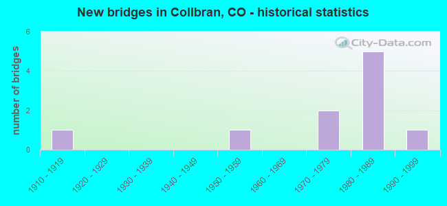
- New bridges - historical statistics
- 11910-1919
- 11950-1959
- 21970-1979
- 51980-1989
- 11990-1999

- Bridge Condition - Deck
- 50.0%Good
- 50.0%Satisfactory

- Bridge Condition - Superstructure
- 10.0%Very good
- 30.0%Good
- 50.0%Satisfactory
- 10.0%Fair

- Bridge Condition - Substructure
- 40.0%Good
- 30.0%Satisfactory
- 30.0%Fair

- Bridge Condition - Channel
- 30.0%Very good
- 20.0%Good
- 40.0%Satisfactory
- 10.0%Fair
Find on map >> Show street view
Structure Number: COL-58.5-0.99A, Location: .1 MI S OF CR 330E (Lat: 39.240711, Lng: -107.960850), Route carried "on" structure: City street , Year Built: 1988, Status: Open, Structure Length: 1.77m (5.81ft), Average Daily Traffic: 1,322 (year 2018), Truck Traffic: 10%, Average Future Daily Traffic: 1,996 (year 2038), Design Load: HS 20, Features Intersected: PLATEAU CREEK, Facility Carried by Structure: MAIN STREET
Minimum Vertical Clearance: 30+ m (98+ ft), Kilometerpoint: 0.198, Lanes on structure: 2, Owner: City or Municipal Highway Agency, Approaching Roadway Width: 9.8m (32.2ft), Material/Design: Prestressed concrete, Design/Construction: Tee Beam, Number Of Spans In Main Unit: 1, Length of Maximum Span: 17.1m (56.1ft), Curb or Sidewalk Widths: Left: 1.5m (4.9ft), Right: 0.2m (0.7ft), Curb-To-Curb Width: 10.4m (34.1ft), Out-to-Out Width: 12.8m (42.0ft)
Condition: Deck: Satisfactory, Superstructure: Satisfactory, Substructure: Satisfactory, Channel: Very good, Operating Rating: 46.2 metric tons, Method Used To Determine Operating Rating: Load Factor (LF), Inventory Rating: 24.9 metric tons, Method Used To Determine Inventory Rating: Load Factor (LF), Structural Evaluation: Equal to present minimum criteria, Deck Geometry: Equal to present minimum criteria, Waterway Adequacy: Equal to present desirable criteria, Approach Roadway Alignment: Equal to present minimum criteria, Designated Inspection Frequency: Every 24 months, Inspection Date: January 2022, Deck Structure Type: Other, Wearing Surface/Protective System: Wearing Surface: Bituminous, Membrane: Built-up
Find on map >> Show street view
Structure Number: COL-P-58.4A, Location: JUST S OF PE ROAD (Lat: 39.241397, Lng: -107.963533), Route carried "on" structure: City street , Year Built: 1987, Status: Open, Structure Length: 1.62m (5.31ft), Average Daily Traffic: 393 (year 2018), Truck Traffic: 2%, Average Future Daily Traffic: 593 (year 2038), Design Load: HS 20, Features Intersected: BUZZARD CREEK, Facility Carried by Structure: BUZZARD CREEK RD
Minimum Vertical Clearance: 30+ m (98+ ft), Kilometerpoint: 0.231, Lanes on structure: 2, Owner: City or Municipal Highway Agency, Approaching Roadway Width: 7.9m (25.9ft), Skew: 1 degrees, Material/Design: Prestressed concrete, Design/Construction: Tee Beam, Number Of Spans In Main Unit: 1, Length of Maximum Span: 14.6m (47.9ft), Curb or Sidewalk Widths: Left: 0.0m, Right: 1.2m (3.9ft), Curb-To-Curb Width: 7.8m (25.6ft), Out-to-Out Width: 9.8m (32.2ft)
Condition: Deck: Good, Superstructure: Good, Substructure: Good, Channel: Good, Operating Rating: 52.2 metric tons, Method Used To Determine Operating Rating: Load Factor (LF), Inventory Rating: 29.5 metric tons, Method Used To Determine Inventory Rating: Load Factor (LF), Structural Evaluation: Better than present minimum criteria, Deck Geometry: Somewhat better than minimum adequacy, Waterway Adequacy: Equal to present desirable criteria, Approach Roadway Alignment: Equal to present minimum criteria, Designated Inspection Frequency: Every 24 months, Inspection Date: January 2022, Deck Structure Type: Other, Wearing Surface/Protective System: Wearing Surface: Bituminous
Find on map >> Show street view
Structure Number: COL-PINION, Location: JUST W OF RIVER COURT (Lat: 39.240289, Lng: -107.964642), Route carried "on" structure: City street , Year Built: 1990, Status: Open, Structure Length: 0.73m (2.40ft), Average Daily Traffic: 38 (year 2018), Average Future Daily Traffic: 58 (year 2038), Design Load: HS 20, Features Intersected: GROVE CREEK, Facility Carried by Structure: PINION STREET
Minimum Vertical Clearance: 30+ m (98+ ft), Kilometerpoint: 0.056, Lanes on structure: 2, Owner: City or Municipal Highway Agency, Approaching Roadway Width: 8.5m (27.9ft), Material/Design: Steel, Design/Construction: Stringer/Multi-beam, Number Of Spans In Main Unit: 1, Length of Maximum Span: 6.8m (22.3ft), Curb-To-Curb Width: 8.6m (28.2ft), Out-to-Out Width: 8.6m (28.2ft)
Condition: Deck: Good, Superstructure: Satisfactory, Substructure: Good, Channel: Very good, Operating Rating: 34.8 metric tons, Method Used To Determine Operating Rating: Load Factor (LF), Inventory Rating: 20.9 metric tons, Method Used To Determine Inventory Rating: Load Factor (LF), Structural Evaluation: Equal to present minimum criteria, Deck Geometry: Better than present minimum criteria, Waterway Adequacy: Equal to present desirable criteria, Approach Roadway Alignment: Equal to present desirable criteria, Designated Inspection Frequency: Every 24 months, Inspection Date: January 2022, Deck Structure Type: Corrugated Steel, Wearing Surface/Protective System: Wearing Surface: Bituminous
Find on map >> Show street view
Structure Number: H-04-E, Location: 3.5 MI W OF COLLBRAN (Lat: 39.224286, Lng: -108.020322), Route carried "on" structure: State highway 330A, Year Built: 1954, Status: Open, Structure Length: 3.08m (10.10ft), Average Daily Traffic: 1,600 (year 2020), Truck Traffic: 9%, Average Future Daily Traffic: 1,904 (year 2040), Design Load: H 20, Features Intersected: PLATEAU CREEK, Facility Carried by Structure: SH 330 ML
Minimum Vertical Clearance: 30+ m (98+ ft), Kilometerpoint: 12.820, Lanes on structure: 2, Owner: State Highway Agency, Approaching Roadway Width: 6.7m (22.0ft), Skew: 3 degrees, Material/Design: Steel, Design/Construction: Stringer/Multi-beam, Number Of Spans In Main Unit: 2, Length of Maximum Span: 19.8m (65.0ft), Curb-To-Curb Width: 7.3m (24.0ft), Out-to-Out Width: 8.5m (27.9ft)
Condition: Deck: Good, Superstructure: Satisfactory, Substructure: Satisfactory, Channel: Good, Operating Rating: 34.4 metric tons, Method Used To Determine Operating Rating: Load Factor (LF), Inventory Rating: 20.7 metric tons, Method Used To Determine Inventory Rating: Load Factor (LF), Structural Evaluation: Somewhat better than minimum adequacy, Deck Geometry: Meets minimum limits, Waterway Adequacy: Equal to present desirable criteria, Approach Roadway Alignment: Better than present minimum criteria, Length Of Structure Improvement: 3.08m (10.10ft), Designated Inspection Frequency: Every 24 months, Inspection Date: August 2020, Bridge Improvement Cost: $102,000, Roadway Improvement Cost: $10,000, Total Project Cost: $153,000, Deck Structure Type: Concrete Cast-file-Place, Wearing Surface/Protective System: Wearing Surface: Bituminous
Find on map >> Show street view
Structure Number: H-04-G, Location: 3 MI W OF COLLBRAN (Lat: 39.228933, Lng: -108.010300), Route carried "on" structure: State highway 330A, Year Built: 1918, Year Reconstructed: 1951, Status: Open, Structure Length: 1.07m (3.51ft), Average Daily Traffic: 1,600 (year 2020), Truck Traffic: 9%, Average Future Daily Traffic: 1,904 (year 2040), Design Load: H 10, Features Intersected: BIG CREEK, Facility Carried by Structure: SH 330 ML
Minimum Vertical Clearance: 30+ m (98+ ft), Kilometerpoint: 13.889, Lanes on structure: 2, Owner: State Highway Agency, Approaching Roadway Width: 6.7m (22.0ft), Material/Design: Steel continuous, Design/Construction: Stringer/Multi-beam, Number Of Spans In Main Unit: 2, Length of Maximum Span: 4.9m (16.1ft), Curb-To-Curb Width: 7.7m (25.3ft), Out-to-Out Width: 9.8m (32.2ft)
Condition: Deck: Satisfactory, Superstructure: Fair, Substructure: Fair, Channel: Fair, Operating Rating: 41.7 metric tons, Method Used To Determine Operating Rating: Load Factor (LF), Inventory Rating: 24.5 metric tons, Method Used To Determine Inventory Rating: Load Factor (LF), Structural Evaluation: Somewhat better than minimum adequacy, Deck Geometry: Meets minimum limits, Waterway Adequacy: Better than present minimum criteria, Approach Roadway Alignment: Better than present minimum criteria, Length Of Structure Improvement: 1.07m (3.51ft), Designated Inspection Frequency: Every 24 months, Inspection Date: August 2020, Bridge Improvement Cost: $41,000, Roadway Improvement Cost: $4,000, Total Project Cost: $61,000, Deck Structure Type: Concrete Cast-file-Place, Wearing Surface/Protective System: Wearing Surface: Bituminous
Find on map >> Show street view
Structure Number: H-04-T, Location: 5 MI W OF COLLBRAN (Lat: 39.207064, Lng: -108.038114), Route carried "on" structure: State highway 330A, Year Built: 1975, Status: Open, Structure Length: 3.60m (11.81ft), Average Daily Traffic: 1,600 (year 2020), Truck Traffic: 9%, Average Future Daily Traffic: 1,904 (year 2040), Design Load: HS 20, Features Intersected: PLATEAU CREEK, Facility Carried by Structure: SH 330 ML
Minimum Vertical Clearance: 30+ m (98+ ft), Kilometerpoint: 10.216, Lanes on structure: 2, Owner: State Highway Agency, Approaching Roadway Width: 9.8m (32.2ft), Skew: 3 degrees, Material/Design: Prestressed concrete continuous, Design/Construction: Stringer/Multi-beam, Number Of Spans In Main Unit: 2, Length of Maximum Span: 17.4m (57.1ft), Curb-To-Curb Width: 11.0m (36.1ft), Out-to-Out Width: 11.7m (38.4ft)
Condition: Deck: Satisfactory, Superstructure: Very good, Substructure: Good, Channel: Very good, Operating Rating: 97.7 metric tons, Method Used To Determine Operating Rating: Load Factor (LF), Inventory Rating: 55.5 metric tons, Method Used To Determine Inventory Rating: Load Factor (LF), Structural Evaluation: Better than present minimum criteria, Deck Geometry: Equal to present minimum criteria, Waterway Adequacy: Equal to present desirable criteria, Approach Roadway Alignment: Better than present minimum criteria, Designated Inspection Frequency: Every 24 months, Inspection Date: August 2020, Deck Structure Type: Concrete Cast-file-Place, Wearing Surface/Protective System: Wearing Surface: Bituminous
Find on map >> Show street view
Structure Number: MESA-56.5-O.7A, Location: JUST N OF RD 330 (Lat: 39.231611, Lng: -108.005611), Route carried "on" structure: County highway , Year Built: 1984, Status: Open, Structure Length: 1.61m (5.28ft), Average Daily Traffic: 58 (year 2018), Average Future Daily Traffic: 87 (year 2038), Features Intersected: PLATEAU CREEK, Facility Carried by Structure: COUNTY ROAD 56.5
Minimum Vertical Clearance: 30+ m (98+ ft), Kilometerpoint: 0.178, Lanes on structure: 2, Owner: County Highway Agency, Approaching Roadway Width: 5.5m (18.0ft), Material/Design: Prestressed concrete, Design/Construction: Tee Beam, Number Of Spans In Main Unit: 1, Length of Maximum Span: 14.6m (47.9ft), Curb-To-Curb Width: 4.9m (16.1ft), Out-to-Out Width: 5.6m (18.4ft)
Condition: Deck: Satisfactory, Superstructure: Satisfactory, Substructure: Satisfactory, Channel: Satisfactory, Operating Rating: 36.3 metric tons, Method Used To Determine Operating Rating: Field evaluation and documented engineering judgment, Inventory Rating: 32.7 metric tons, Method Used To Determine Inventory Rating: Field evaluation and documented engineering judgment, Structural Evaluation: Equal to present minimum criteria, Deck Geometry: High priority of corrective action, Waterway Adequacy: Equal to present desirable criteria, Approach Roadway Alignment: Equal to present minimum criteria, Designated Inspection Frequency: Every 24 months, Inspection Date: January 2022, Deck Structure Type: Other, Wearing Surface/Protective System: Wearing Surface: Gravel
Find on map >> Show street view
Structure Number: MESA-57-N.5A, Location: .7 MI N OF CR KE (Lat: 39.218556, Lng: -107.988944), Route carried "on" structure: County highway , Year Built: 1988, Status: Open, Structure Length: 1.83m (6.00ft), Average Daily Traffic: 118 (year 2018), Truck Traffic: 2%, Average Future Daily Traffic: 178 (year 2038), Features Intersected: BIG CREEK, Facility Carried by Structure: COUNTY ROAD 57
Minimum Vertical Clearance: 30+ m (98+ ft), Kilometerpoint: 2.438, Lanes on structure: 2, Owner: County Highway Agency, Approaching Roadway Width: 6.7m (22.0ft), Skew: 1 degrees, Material/Design: Prestressed concrete, Design/Construction: Tee Beam, Number Of Spans In Main Unit: 1, Length of Maximum Span: 17.2m (56.4ft), Curb-To-Curb Width: 9.0m (29.5ft), Out-to-Out Width: 9.8m (32.2ft)
Condition: Deck: Good, Superstructure: Good, Substructure: Good, Channel: Satisfactory, Operating Rating: 85.1 metric tons, Method Used To Determine Operating Rating: Load Factor (LF), Inventory Rating: 47.6 metric tons, Method Used To Determine Inventory Rating: Load Factor (LF), Structural Evaluation: Better than present minimum criteria, Deck Geometry: Equal to present minimum criteria, Waterway Adequacy: Superior to present desirable criteria, Approach Roadway Alignment: Somewhat better than minimum adequacy, Designated Inspection Frequency: Every 24 months, Inspection Date: January 2022, Deck Structure Type: Other, Wearing Surface/Protective System: Wearing Surface: Bituminous, Membrane: Built-up
Find on map >> Show street view
Structure Number: MESA-58-M.6, Location: 0.1 MI E OF CR ME.75 (Lat: 39.205000, Lng: -107.969806), Route carried "on" structure: County highway , Year Built: 1975, Status: Posted for load, Structure Length: 0.77m (2.53ft), Average Daily Traffic: 147 (year 2018), Truck Traffic: 2%, Average Future Daily Traffic: 222 (year 2038), Features Intersected: BIG CREEK, Facility Carried by Structure: COUNTY ROAD 58
Minimum Vertical Clearance: 30+ m (98+ ft), Kilometerpoint: 4.136, Lanes on structure: 2, Owner: County Highway Agency, Approaching Roadway Width: 7.3m (24.0ft), Skew: 1 degrees, Material/Design: Steel, Design/Construction: Stringer/Multi-beam, Number Of Spans In Main Unit: 1, Length of Maximum Span: 6.2m (20.3ft), Curb-To-Curb Width: 6.5m (21.3ft), Out-to-Out Width: 6.6m (21.7ft)
Condition: Deck: Good, Superstructure: Satisfactory, Substructure: Fair, Channel: Satisfactory, Operating Rating: 29.8 metric tons, Method Used To Determine Operating Rating: Load Factor (LF), Inventory Rating: 17.8 metric tons, Method Used To Determine Inventory Rating: Load Factor (LF), Structural Evaluation: Somewhat better than minimum adequacy, Deck Geometry: Meets minimum limits, Waterway Adequacy: Equal to present desirable criteria, Approach Roadway Alignment: High priority of corrective action, Bridge Posting: Required (Relationship of Operating Rating to Maximum Legal Load: 0.1 - 9.9% below), Designated Inspection Frequency: Every 24 months, Inspection Date: January 2022, Deck Structure Type: Corrugated Steel, Wearing Surface/Protective System: Wearing Surface: Bituminous
Find on map >> Show street view
Structure Number: MESA-60.5-P.8A, Location: JUST SE OF RD 330E (Lat: 39.253389, Lng: -107.921389), Route carried "on" structure: County highway , Year Built: 1989, Status: Open, Structure Length: 1.23m (4.04ft), Average Daily Traffic: 102 (year 2018), Truck Traffic: 2%, Average Future Daily Traffic: 155 (year 2038), Design Load: HS 20, Features Intersected: PLATEAU CREEK, Facility Carried by Structure: COUNTY ROAD 60.5
Minimum Vertical Clearance: 30+ m (98+ ft), Kilometerpoint: 0.402, Lanes on structure: 2, Owner: County Highway Agency, Approaching Roadway Width: 7.0m (23.0ft), Skew: 1 degrees, Material/Design: Steel, Design/Construction: Stringer/Multi-beam, Number Of Spans In Main Unit: 1, Length of Maximum Span: 11.4m (37.4ft), Curb-To-Curb Width: 7.8m (25.6ft), Out-to-Out Width: 8.0m (26.2ft)
Condition: Deck: Satisfactory, Superstructure: Good, Substructure: Fair, Channel: Satisfactory, Operating Rating: 33.5 metric tons, Method Used To Determine Operating Rating: Load Factor (LF), Inventory Rating: 20.0 metric tons, Method Used To Determine Inventory Rating: Load Factor (LF), Structural Evaluation: Somewhat better than minimum adequacy, Deck Geometry: Somewhat better than minimum adequacy, Waterway Adequacy: Equal to present desirable criteria, Approach Roadway Alignment: Somewhat better than minimum adequacy, Designated Inspection Frequency: Every 24 months, Inspection Date: January 2022, Deck Structure Type: Corrugated Steel, Wearing Surface/Protective System: Wearing Surface: Bituminous