Bridge Statistics for College, Alaska (AK)
Condition, Traffic, Stress, Structural Evaluation, Project Costs
- National Bridge Inventory (NBI) Statistics
- 18Number of bridges
- 233ft / 70.6mTotal length
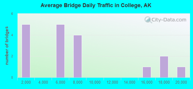
- 119,536Total average daily traffic
- 5,538Total average daily truck traffic
- National Bridge Inventory (NBI) Registered Bridges for College
- No street view available for this location
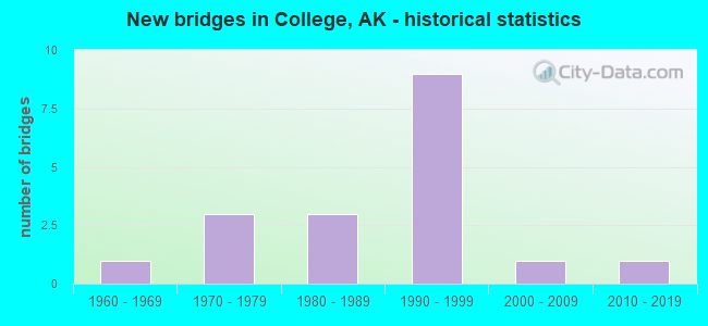
- New bridges - historical statistics
- 11960-1969
- 31970-1979
- 31980-1989
- 91990-1999
- 12000-2009
- 12010-2019
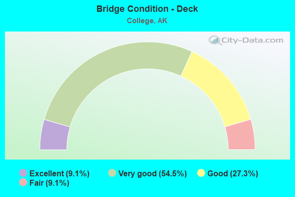
- Bridge Condition - Deck
- 9.1%Excellent
- 54.5%Very good
- 27.3%Good
- 9.1%Fair
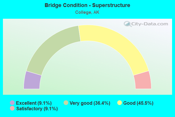
- Bridge Condition - Superstructure
- 9.1%Excellent
- 36.4%Very good
- 45.5%Good
- 9.1%Satisfactory
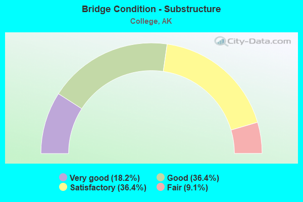
- Bridge Condition - Substructure
- 18.2%Very good
- 36.4%Good
- 36.4%Satisfactory
- 9.1%Fair
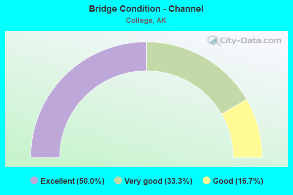
- Bridge Condition - Channel
- 50.0%Excellent
- 33.3%Very good
- 16.7%Good
Find on map >> Show street view
Structure Number: 214, Location: MILE POINT 38.4 (Lat: 60.799444, Lng: -151.013056), Route carried "on" structure: State highway 490, Year Built: 1966, Status: Open, Structure Length: 6.43m (21.10ft), Average Daily Traffic: 260 (year 2020), Truck Traffic: 14%, Average Future Daily Traffic: 300 (year 2039), Design Load: HS 20, Features Intersected: SWANSON RIVER, Facility Carried by Structure: KENAI SPUR
Minimum Vertical Clearance: 30+ m (98+ ft), Kilometerpoint: 61.786, Lanes on structure: 2, Owner: State Highway Agency, Approaching Roadway Width: 9.1m (29.9ft), Material/Design: Steel continuous, Design/Construction: Stringer/Multi-beam, Number Of Spans In Main Unit: 3, Length of Maximum Span: 24.4m (80.1ft), Curb-To-Curb Width: 9.1m (29.9ft), Out-to-Out Width: 10.2m (33.5ft)
Condition: Deck: Good, Superstructure: Good, Substructure: Satisfactory, Channel: Very good, Operating Rating: 72.2 metric tons, Method Used To Determine Operating Rating: Load Factor (LF), Inventory Rating: 32.1 metric tons, Method Used To Determine Inventory Rating: Load Factor (LF), Structural Evaluation: Equal to present minimum criteria, Deck Geometry: Equal to present minimum criteria, Waterway Adequacy: Equal to present desirable criteria, Approach Roadway Alignment: Equal to present desirable criteria, Designated Inspection Frequency: Every 24 months, Inspection Date: August 2021, Deck Structure Type: Concrete Cast-file-Place, Wearing Surface/Protective System: Wearing Surface: Bituminous, Membrane: Preformed Fabric
Find on map >> Show street view
Structure Number: 1161, Location: MILE POINT 319.2 (Lat: 64.840864, Lng: -147.844014), Route carried "on" structure: Interstate A45, Year Built: 1975, Status: Open, Structure Length: 15.81m (51.87ft), Average Daily Traffic: 7,700 (year 2020), Truck Traffic: 2%, Average Future Daily Traffic: 13,350 (year 2039), Design Load: HS 20, Features Intersected: CHENA RIV (PARKS HWY) SB, Facility Carried by Structure: PARKS HIGHWAY
Minimum Vertical Clearance: 5.42m (17.78ft), Kilometerpoint: 513.733, Lanes on structure: 2, Lanes under structure: 2, Base Highway Network: Yes, Owner: State Highway Agency, Approaching Roadway Width: 11.3m (37.1ft), Skew: 2 degrees, Navigation Control: Yes ( Vertical Clearance: 7.0m (23.0ft), Horizontal Clearance: 33.5m (109.9ft)), Material/Design: Prestressed concrete, Design/Construction: Tee Beam, Number Of Spans In Main Unit: 4, Length of Maximum Span: 39.3m (128.9ft), Curb or Sidewalk Widths: Left: 1.8m (5.9ft), Right: 0.0m, Curb-To-Curb Width: 11.6m (38.1ft), Out-to-Out Width: 14.3m (46.9ft)
Condition: Deck: Good, Superstructure: Good, Substructure: Good, Channel: Good, Operating Rating: 76.7 metric tons, Method Used To Determine Operating Rating: Load Factor (LF), Inventory Rating: 39.2 metric tons, Method Used To Determine Inventory Rating: Load Factor (LF), Structural Evaluation: Better than present minimum criteria, Deck Geometry: Equal to present minimum criteria, Underclear: High priority of corrective action, Waterway Adequacy: Equal to present minimum criteria, Approach Roadway Alignment: Equal to present desirable criteria, Designated Inspection Frequency: Every 24 months, Inspection Date: July 2020, Deck Structure Type: Other, Wearing Surface/Protective System: Wearing Surface: Bituminous, Membrane: Preformed Fabric
Find on map >> Show street view
Structure Number: 1244, Location: MILE POINT 319.489 (Lat: 64.836528, Lng: -147.834258), Route carried "on" structure: Interstate A45, Year Built: 1985, Status: Open, Structure Length: 3.81m (12.50ft), Average Daily Traffic: 5,200 (year 2020), Truck Traffic: 8%, Average Future Daily Traffic: 6,200 (year 2039), Design Load: HS 20, Features Intersected: AIRPORT WAY UC SB, Facility Carried by Structure: PARKS HIGHWAY
Minimum Vertical Clearance: 5.42m (17.78ft), Kilometerpoint: 514.168, Lanes on structure: 3, Lanes under structure: 6, Base Highway Network: Yes, Owner: State Highway Agency, Approaching Roadway Width: 11.6m (38.1ft), Skew: 1 degrees, Material/Design: Prestressed concrete, Design/Construction: Tee Beam, Number Of Spans In Main Unit: 1, Length of Maximum Span: 37.8m (124.0ft), Curb-To-Curb Width: 15.2m (49.9ft), Out-to-Out Width: 16.0m (52.5ft)
Condition: Deck: Very good, Superstructure: Good, Substructure: Very good, Operating Rating: 73.6 metric tons, Method Used To Determine Operating Rating: Load Factor (LF), Inventory Rating: 35.9 metric tons, Method Used To Determine Inventory Rating: Load Factor (LF), Structural Evaluation: Better than present minimum criteria, Deck Geometry: Meets minimum limits, Underclear: Meets minimum limits, Approach Roadway Alignment: Equal to present desirable criteria, Designated Inspection Frequency: Every 24 months, Inspection Date: July 2020, Deck Structure Type: Other, Wearing Surface/Protective System: Wearing Surface: Bituminous, Membrane: Preformed Fabric, Deck Protection: Epoxy Coated Reinforcing
Find on map >> Show street view
Structure Number: 1686, Location: MILE POINT 0.1 (Lat: 53.896706, Lng: -166.459125), Route carried "on" structure: ServiceOther road NSP00, Year Built: 2014, Status: Posted for load, Structure Length: 2.13m (6.99ft), Average Daily Traffic: 400 (year 2020), Truck Traffic: 14%, Average Future Daily Traffic: 1,310 (year 2039), Design Load: HL 93, Features Intersected: SUMMER BAY CREEK, Facility Carried by Structure: IRR:SUMMER BAY RD
Minimum Vertical Clearance: 30+ m (98+ ft), Kilometerpoint: 0.116, Lanes on structure: 2, Owner: City or Municipal Highway Agency, Approaching Roadway Width: 9.4m (30.8ft), Material/Design: Steel, Design/Construction: Stringer/Multi-beam, Number Of Spans In Main Unit: 1, Length of Maximum Span: 19.5m (64.0ft), Curb-To-Curb Width: 7.3m (24.0ft), Out-to-Out Width: 8.0m (26.2ft)
Condition: Deck: Excellent, Superstructure: Excellent, Substructure: Very good, Channel: Excellent, Operating Rating: 98.9 metric tons, Method Used To Determine Operating Rating: Load Factor (LF), Inventory Rating: 45.6 metric tons, Method Used To Determine Inventory Rating: Load Factor (LF), Structural Evaluation: Equal to present desirable criteria, Deck Geometry: Somewhat better than minimum adequacy, Waterway Adequacy: Equal to present desirable criteria, Approach Roadway Alignment: Equal to present minimum criteria, Designated Inspection Frequency: Every 24 months, Inspection Date: September 2020, Deck Structure Type: Concrete Cast-file-Place, Wearing Surface/Protective System: Wearing Surface: Monolithic Concrete, Deck Protection: Epoxy Coated Reinforcing
Find on map >> Show street view
Structure Number: 1689, Location: MILE POINT 44.1 (Lat: 64.692403, Lng: -164.280219), Route carried "on" structure: State highway 130, Year Built: 1987, Status: Open, Structure Length: 4.57m (14.99ft), Average Daily Traffic: 160 (year 2020), Truck Traffic: 8%, Average Future Daily Traffic: 490 (year 2039), Design Load: HS 20, Features Intersected: EAST FORK SOLOMON RIVER, Facility Carried by Structure: IRR:NOME-COUNCIL
Minimum Vertical Clearance: 30+ m (98+ ft), Kilometerpoint: 70.913, Lanes on structure: 2, Owner: State Highway Agency, Approaching Roadway Width: 7.3m (24.0ft), Material/Design: Prestressed concrete, Design/Construction: Tee Beam, Number Of Spans In Main Unit: 2, Length of Maximum Span: 22.6m (74.1ft), Curb-To-Curb Width: 7.3m (24.0ft), Out-to-Out Width: 7.6m (24.9ft)
Condition: Deck: Fair, Superstructure: Satisfactory, Substructure: Fair, Channel: Very good, Operating Rating: 83.3 metric tons, Method Used To Determine Operating Rating: Load Factor (LF), Inventory Rating: 32.3 metric tons, Method Used To Determine Inventory Rating: Load Factor (LF), Structural Evaluation: Somewhat better than minimum adequacy, Deck Geometry: Somewhat better than minimum adequacy, Waterway Adequacy: Equal to present desirable criteria, Approach Roadway Alignment: Equal to present desirable criteria, Designated Inspection Frequency: Every 24 months, Inspection Date: August 2020, Deck Structure Type: Other, Wearing Surface/Protective System: Wearing Surface: Monolithic Concrete, Deck Protection: Epoxy Coated Reinforcing
Find on map >> Show street view
Structure Number: 1793, Location: MILE POINT 0.2 (Lat: 64.849347, Lng: -147.805772), Route carried "on" structure: State highway 668, Year Built: 1993, Status: Open, Structure Length: 4.24m (13.91ft), Average Daily Traffic: 18,000 (year 2020), Truck Traffic: 7%, Average Future Daily Traffic: 22,100 (year 2039), Design Load: HS 25 or greater, Features Intersected: NOYES SLOUGH (GEIST RD), Facility Carried by Structure: JOHANSEN EXPRESSWY
Minimum Vertical Clearance: 5.33m (17.49ft), Kilometerpoint: 0.285, Lanes on structure: 4, Base Highway Network: Yes, Owner: State Highway Agency, Approaching Roadway Width: 24.4m (80.1ft), Skew: 35 degrees, Material/Design: Prestressed concrete, Design/Construction: Tee Beam, Number Of Spans In Main Unit: 1, Length of Maximum Span: 39.8m (130.6ft), Curb or Sidewalk Widths: Left: 3.7m (12.1ft), Right: 3.7m (12.1ft), Curb-To-Curb Width: 24.4m (80.1ft), Out-to-Out Width: 34.2m (112.2ft)
Condition: Deck: Very good, Superstructure: Very good, Substructure: Good, Channel: Excellent, Operating Rating: 87.7 metric tons, Method Used To Determine Operating Rating: Load Factor (LF), Inventory Rating: 37.6 metric tons, Method Used To Determine Inventory Rating: Load Factor (LF), Structural Evaluation: Better than present minimum criteria, Deck Geometry: Superior to present desirable criteria, Waterway Adequacy: Superior to present desirable criteria, Approach Roadway Alignment: Equal to present desirable criteria, Designated Inspection Frequency: Every 24 months, Inspection Date: August 2020, Deck Structure Type: Other, Wearing Surface/Protective System: Wearing Surface: Bituminous, Deck Protection: Epoxy Coated Reinforcing
Find on map >> Show street view
Structure Number: 1878, Location: MILE POINT 318.6 (Lat: 64.848447, Lng: -147.863975), Route carried "on" structure: Interstate A45, Year Built: 1997, Status: Open, Structure Length: 3.26m (10.70ft), Average Daily Traffic: 4,605 (year 2020), Truck Traffic: 8%, Average Future Daily Traffic: 8,800 (year 2039), Design Load: HS 25 or greater, Features Intersected: PARKS/CHENA RIDGE SB, Facility Carried by Structure: PARKS HIGHWAY
Minimum Vertical Clearance: 30+ m (98+ ft), Kilometerpoint: 512.627, Lanes on structure: 2, Lanes under structure: 5, Base Highway Network: Yes, Owner: State Highway Agency, Approaching Roadway Width: 11.0m (36.1ft), Material/Design: Prestressed concrete, Design/Construction: Tee Beam, Number Of Spans In Main Unit: 1, Length of Maximum Span: 32.2m (105.6ft), Curb-To-Curb Width: 10.8m (35.4ft), Out-to-Out Width: 12.0m (39.4ft)
Condition: Deck: Very good, Superstructure: Good, Substructure: Satisfactory, Operating Rating: 80.1 metric tons, Method Used To Determine Operating Rating: Load Factor (LF), Inventory Rating: 36.9 metric tons, Method Used To Determine Inventory Rating: Load Factor (LF), Structural Evaluation: Equal to present minimum criteria, Deck Geometry: Meets minimum limits, Underclear: Equal to present minimum criteria, Approach Roadway Alignment: Equal to present desirable criteria, Designated Inspection Frequency: Every 24 months, Inspection Date: July 2020, Deck Structure Type: Other, Wearing Surface/Protective System: Wearing Surface: Bituminous, Membrane: Preformed Fabric, Deck Protection: Epoxy Coated Reinforcing
Find on map >> Show street view
Structure Number: 1879, Location: MILE POINT 318.5 (Lat: 64.848350, Lng: -147.864361), Route carried "on" structure: Interstate A45, Year Built: 1997, Status: Open, Structure Length: 3.26m (10.70ft), Average Daily Traffic: 4,605 (year 2020), Truck Traffic: 4%, Average Future Daily Traffic: 8,800 (year 2039), Design Load: HS 25 or greater, Features Intersected: PARKS/CHENA RIDGE NB, Facility Carried by Structure: PARKS HIGHWAY
Minimum Vertical Clearance: 30+ m (98+ ft), Kilometerpoint: 512.624, Lanes on structure: 2, Lanes under structure: 5, Base Highway Network: Yes, Owner: State Highway Agency, Approaching Roadway Width: 11.0m (36.1ft), Material/Design: Prestressed concrete, Design/Construction: Tee Beam, Number Of Spans In Main Unit: 1, Length of Maximum Span: 32.2m (105.6ft), Curb-To-Curb Width: 10.8m (35.4ft), Out-to-Out Width: 12.0m (39.4ft)
Condition: Deck: Very good, Superstructure: Good, Substructure: Satisfactory, Operating Rating: 80.1 metric tons, Method Used To Determine Operating Rating: Load Factor (LF), Inventory Rating: 36.9 metric tons, Method Used To Determine Inventory Rating: Load Factor (LF), Structural Evaluation: Equal to present minimum criteria, Deck Geometry: Meets minimum limits, Underclear: Equal to present minimum criteria, Approach Roadway Alignment: Equal to present desirable criteria, Designated Inspection Frequency: Every 24 months, Inspection Date: July 2020, Deck Structure Type: Other, Wearing Surface/Protective System: Wearing Surface: Bituminous, Membrane: Preformed Fabric, Deck Protection: Epoxy Coated Reinforcing
Find on map >> Show street view
Structure Number: 1913, Location: MILE POINT 319.2 (Lat: 64.840789, Lng: -147.844478), Route carried "on" structure: Interstate A45, Year Built: 1995, Status: Open, Structure Length: 15.86m (52.03ft), Average Daily Traffic: 7,700 (year 2020), Truck Traffic: 2%, Average Future Daily Traffic: 13,350 (year 2039), Design Load: HS 25 or greater, Features Intersected: CHENA RIV (PARKS HWY) NB, Facility Carried by Structure: PARKS HIGHWAY
Minimum Vertical Clearance: 5.42m (17.78ft), Kilometerpoint: 513.733, Lanes on structure: 2, Lanes under structure: 2, Base Highway Network: Yes, Owner: State Highway Agency, Approaching Roadway Width: 11.3m (37.1ft), Skew: 2 degrees, Navigation Control: Yes ( Vertical Clearance: 7.0m (23.0ft), Horizontal Clearance: 33.5m (109.9ft)), Material/Design: Prestressed concrete, Design/Construction: Tee Beam, Number Of Spans In Main Unit: 4, Length of Maximum Span: 39.4m (129.3ft), Curb-To-Curb Width: 11.0m (36.1ft), Out-to-Out Width: 11.9m (39.0ft)
Condition: Deck: Very good, Superstructure: Very good, Substructure: Good, Channel: Excellent, Operating Rating: 80.1 metric tons, Method Used To Determine Operating Rating: Load Factor (LF), Inventory Rating: 36.9 metric tons, Method Used To Determine Inventory Rating: Load Factor (LF), Structural Evaluation: Better than present minimum criteria, Deck Geometry: Somewhat better than minimum adequacy, Underclear: High priority of corrective action, Waterway Adequacy: Equal to present desirable criteria, Approach Roadway Alignment: Equal to present desirable criteria, Designated Inspection Frequency: Every 24 months, Inspection Date: July 2020, Deck Structure Type: Other, Wearing Surface/Protective System: Wearing Surface: Bituminous, Membrane: Preformed Fabric, Deck Protection: Epoxy Coated Reinforcing
Find on map >> Show street view
Structure Number: 1914, Location: MILE POINT 320.1 (Lat: 64.836456, Lng: -147.834839), Route carried "on" structure: Interstate A45, Year Built: 1995, Status: Open, Structure Length: 3.83m (12.57ft), Average Daily Traffic: 5,200 (year 2020), Truck Traffic: 8%, Average Future Daily Traffic: 6,200 (year 2039), Design Load: HS 25 or greater, Features Intersected: AIRPORT WAY UC NB, Facility Carried by Structure: PARKS HIGHWAY
Minimum Vertical Clearance: 5.42m (17.78ft), Kilometerpoint: 515.025, Lanes on structure: 3, Lanes under structure: 6, Base Highway Network: Yes, Owner: State Highway Agency, Approaching Roadway Width: 11.6m (38.1ft), Skew: 1 degrees, Material/Design: Prestressed concrete, Design/Construction: Tee Beam, Number Of Spans In Main Unit: 1, Length of Maximum Span: 37.8m (124.0ft), Curb-To-Curb Width: 14.6m (47.9ft), Out-to-Out Width: 15.5m (50.9ft)
Condition: Deck: Good, Superstructure: Very good, Substructure: Satisfactory, Operating Rating: 95.9 metric tons, Method Used To Determine Operating Rating: Load Factor (LF), Inventory Rating: 44.1 metric tons, Method Used To Determine Inventory Rating: Load Factor (LF), Structural Evaluation: Equal to present minimum criteria, Deck Geometry: Meets minimum limits, Underclear: Meets minimum limits, Approach Roadway Alignment: Equal to present desirable criteria, Designated Inspection Frequency: Every 24 months, Inspection Date: July 2020, Deck Structure Type: Other, Wearing Surface/Protective System: Wearing Surface: Bituminous, Membrane: Preformed Fabric, Deck Protection: Epoxy Coated Reinforcing
Find on map >> Show street view
Structure Number: 1981, Location: UNIVERISTY OF AK (Lat: 64.854442, Lng: -147.840756), Route carried "on" structure: State highway , Year Built: 2005, Status: Open, Structure Length: 7.40m (24.28ft), Average Daily Traffic: 4,120 (year 2020), Truck Traffic: 4%, Average Future Daily Traffic: 5,270 (year 2039), Design Load: HL 93, Features Intersected: THOMPSON DR OVERHEAD, Facility Carried by Structure: THOMPSON DRIVE
Minimum Vertical Clearance: 30+ m (98+ ft), Kilometerpoint: 0.541, Lanes on structure: 2, Owner: State Agenciy, Approaching Roadway Width: 13.1m (43.0ft), Material/Design: Prestressed concrete, Design/Construction: Tee Beam, Number Of Spans In Main Unit: 3, Length of Maximum Span: 25.3m (83.0ft), Curb or Sidewalk Widths: Left: 0.0m, Right: 3.0m (9.8ft), Curb-To-Curb Width: 13.1m (43.0ft), Out-to-Out Width: 17.0m (55.8ft)
Condition: Deck: Very good, Superstructure: Very good, Substructure: Good, Inventory Rating: 47.2 metric tons, Method Used To Determine Inventory Rating: Load Factor (LF), Structural Evaluation: Better than present minimum criteria, Deck Geometry: Equal to present minimum criteria, Underclear: Superior to present desirable criteria, Approach Roadway Alignment: Equal to present minimum criteria, Designated Inspection Frequency: Every 24 months, Inspection Date: August 2020, Deck Structure Type: Other, Wearing Surface/Protective System: Wearing Surface: Bituminous, Membrane: Preformed Fabric, Deck Protection: Epoxy Coated Reinforcing
Find on map >> Show street view
Structure Number: 1161, Location: MILE POINT 319.2 (Lat: 64.840864, Lng: -147.844014), Route carried "under" structure: ServiceCity street , Year Built: 1975, Structure Length: 0. m, Average Daily Traffic: 103 (year 2018), Truck Traffic: 1%, Features Intersected: CHENA RIV (PARKS HWY) SB, Facility Carried by Structure: PARKS HIGHWAY
Minimum Vertical Clearance: 4.29m (14.07ft), Kilometerpoint: 0.644, Lanes on structure: 2, Lanes under structure: 2, Material/Design: Prestressed concrete, Design/Construction: Tee Beam, Length of Maximum Span: 39.3m (128.9ft)
Find on map >> Show street view
Structure Number: 1244, Location: MILE POINT 319.489 (Lat: 64.836528, Lng: -147.834258), Route carried "under" structure: State highway , Year Built: 1985, Structure Length: 0. m, Average Daily Traffic: 6,940 (year 2020), Truck Traffic: 3%, Features Intersected: AIRPORT WAY UC SB, Facility Carried by Structure: PARKS HIGHWAY
Minimum Vertical Clearance: 5.09m (16.70ft), Kilometerpoint: 5.955, Lanes on structure: 3, Lanes under structure: 6, Material/Design: Prestressed concrete, Design/Construction: Tee Beam, Length of Maximum Span: 37.8m (124.0ft)
Find on map >> Show street view
Structure Number: 1318, Location: MILE POINT 0.3 (Lat: 64.849178, Lng: -147.821878), Route carried "under" structure: State highway 649, Year Built: 1975, Structure Length: 0. m, Average Daily Traffic: 14,500 (year 2020), Truck Traffic: 4%, Features Intersected: GEIST ROAD POC, Facility Carried by Structure: UNIVERSITY/GEIST
Minimum Vertical Clearance: 5.65m (18.54ft), Kilometerpoint: 0.444, Lanes under structure: 5, Material/Design: Wood or Timber, Design/Construction: Truss - Thru, Length of Maximum Span: 27.4m (89.9ft)
Find on map >> Show street view
Structure Number: 1878, Location: MILE POINT 318.6 (Lat: 64.848447, Lng: -147.863975), Route carried "under" structure: State highway , Year Built: 1997, Structure Length: 0. m, Average Daily Traffic: 16,500 (year 2020), Truck Traffic: 4%, Features Intersected: PARKS/CHENA RIDGE SB, Facility Carried by Structure: PARKS HIGHWAY
Minimum Vertical Clearance: 4.95m (16.24ft), Kilometerpoint: 2.468, Lanes on structure: 2, Lanes under structure: 5, Material/Design: Prestressed concrete, Design/Construction: Tee Beam, Length of Maximum Span: 32.2m (105.6ft)
Find on map >> Show street view
Structure Number: 1879, Location: MILE POINT 318.5 (Lat: 64.848350, Lng: -147.864361), Route carried "under" structure: State highway , Year Built: 1997, Structure Length: 0. m, Average Daily Traffic: 16,500 (year 2020), Truck Traffic: 4%, Features Intersected: PARKS/CHENA RIDGE NB, Facility Carried by Structure: PARKS HIGHWAY
Minimum Vertical Clearance: 4.95m (16.24ft), Kilometerpoint: 2.468, Lanes on structure: 2, Lanes under structure: 5, Material/Design: Prestressed concrete, Design/Construction: Tee Beam, Length of Maximum Span: 32.2m (105.6ft)
Find on map >> Show street view
Structure Number: 1913, Location: MILE POINT 319.2 (Lat: 64.840789, Lng: -147.844478), Route carried "under" structure: ServiceCity street , Year Built: 1995, Structure Length: 0. m, Average Daily Traffic: 103 (year 2018), Truck Traffic: 1%, Features Intersected: CHENA RIV (PARKS HWY) NB, Facility Carried by Structure: PARKS HIGHWAY
Minimum Vertical Clearance: 4.29m (14.07ft), Kilometerpoint: 0.644, Lanes on structure: 2, Lanes under structure: 2, Material/Design: Prestressed concrete, Design/Construction: Tee Beam, Length of Maximum Span: 39.4m (129.3ft)
Find on map >> Show street view
Structure Number: 1914, Location: MILE POINT 320.1 (Lat: 64.836456, Lng: -147.834839), Route carried "under" structure: State highway , Year Built: 1995, Structure Length: 0. m, Average Daily Traffic: 6,940 (year 2018), Truck Traffic: 3%, Features Intersected: AIRPORT WAY UC NB, Facility Carried by Structure: PARKS HIGHWAY
Minimum Vertical Clearance: 5.09m (16.70ft), Kilometerpoint: 6.179, Lanes on structure: 3, Lanes under structure: 6, Material/Design: Prestressed concrete, Design/Construction: Tee Beam, Length of Maximum Span: 37.8m (124.0ft)