Bridge Statistics for Colony, Kansas (KS)
Condition, Traffic, Stress, Structural Evaluation, Project Costs
- National Bridge Inventory (NBI) Statistics
- 12Number of bridges
- 66ft / 20.3mTotal length
- $203,000Total costs
- 6,986Total average daily traffic
- 1,823Total average daily truck traffic
- 9,442Total future (year 2040) average daily traffic
- National Bridge Inventory (NBI) Registered Bridges for Colony
- No street view available for this location
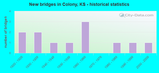
- New bridges - historical statistics
- 21920-1929
- 21930-1939
- 11940-1949
- 11950-1959
- 31960-1969
- 11980-1989
- 11990-1999
- 12000-2009


- Bridge Condition - Deck
- 20.0%Good
- 40.0%Satisfactory
- 40.0%Fair

- Bridge Condition - Superstructure
- 20.0%Very good
- 20.0%Good
- 40.0%Satisfactory
- 20.0%Fair

- Bridge Condition - Substructure
- 40.0%Very good
- 60.0%Satisfactory

- Bridge Condition - Channel
- 16.7%Very good
- 16.7%Good
- 16.7%Satisfactory
- 41.7%Fair
- 8.3%Poor

- Bridge Condition - Culverts
- 14.3%Good
- 71.4%Satisfactory
- 14.3%Fair
Find on map >> Show street view
Structure Number: 1062, Location: 2.0N 0.3W OF CARLYLE (Lat: 38.023992, Lng: -95.394306), Route carried "on" structure: County highway 1858, Year Built: 1966, Status: Open, Structure Length: 1.14m (3.74ft), Average Daily Traffic: 167 (year 2006), Truck Traffic: 10%, Average Future Daily Traffic: 167 (year 2040), Design Load: H 20, Features Intersected: BRANCH OF DEER CREEK
Minimum Vertical Clearance: 30.47m (99.97ft), Kilometerpoint: 1.127, Lanes on structure: 2, Owner: County Highway Agency, Approaching Roadway Width: 8.8m (28.9ft), Material/Design: Concrete, Design/Construction: Culvert, Number Of Spans In Main Unit: 3, Length of Maximum Span: 3.7m (12.1ft), Curb or Sidewalk Widths: Left: 0.2m (0.7ft), Right: 0.2m (0.7ft), Curb-To-Curb Width: 12.2m (40.0ft), Out-to-Out Width: 12.6m (41.3ft)
Condition: Channel: Fair, Culverts: Satisfactory, Operating Rating: 29.7 metric tons, Method Used To Determine Operating Rating: Load Factor (LF), Inventory Rating: 18.0 metric tons, Method Used To Determine Inventory Rating: Load Factor (LF), Structural Evaluation: Somewhat better than minimum adequacy, Deck Geometry: Superior to present desirable criteria, Waterway Adequacy: Equal to present desirable criteria, Approach Roadway Alignment: Equal to present desirable criteria, Length Of Structure Improvement: 1.16m (3.81ft), Designated Inspection Frequency: Every 24 months, Inspection Date: Febuary 2020, Other Special Inspection Date: August 2021, Bridge Improvement Cost: $56,000, Roadway Improvement Cost: $15,000, Total Project Cost: $107,000
Find on map >> Show street view
Structure Number: 1063, Location: 2.0N 0.6E OF CARLYLE (Lat: 38.024042, Lng: -95.379444), Route carried "on" structure: County highway 1858, Year Built: 1966, Status: Open, Structure Length: 0.75m (2.46ft), Average Daily Traffic: 167 (year 2006), Truck Traffic: 10%, Average Future Daily Traffic: 167 (year 2040), Design Load: H 20, Features Intersected: BRANCH OF DEER CREEK
Minimum Vertical Clearance: 30.47m (99.97ft), Kilometerpoint: 2.575, Lanes on structure: 2, Owner: County Highway Agency, Approaching Roadway Width: 9.4m (30.8ft), Material/Design: Concrete, Design/Construction: Culvert, Number Of Spans In Main Unit: 2, Length of Maximum Span: 3.7m (12.1ft), Curb-To-Curb Width: 12.2m (40.0ft), Out-to-Out Width: 12.6m (41.3ft)
Condition: Channel: Fair, Culverts: Satisfactory, Operating Rating: 32.4 metric tons, Method Used To Determine Operating Rating: Load Factor (LF), Inventory Rating: 18.9 metric tons, Method Used To Determine Inventory Rating: Load Factor (LF), Structural Evaluation: Somewhat better than minimum adequacy, Deck Geometry: Superior to present desirable criteria, Waterway Adequacy: Equal to present desirable criteria, Approach Roadway Alignment: Equal to present desirable criteria, Length Of Structure Improvement: 0.76m (2.49ft), Designated Inspection Frequency: Every 24 months, Inspection Date: March 2020, Other Special Inspection Date: August 2021, Bridge Improvement Cost: $44,000, Roadway Improvement Cost: $20,000, Total Project Cost: $96,000
Find on map >> Show street view
Structure Number: 1064, Location: 2.0N 2.2E OF CARLYLE (Lat: 38.023722, Lng: -95.348972), Route carried "on" structure: County highway 1858, Year Built: 1966, Status: Posted for load, Structure Length: 5.79m (19.00ft), Average Daily Traffic: 167 (year 2006), Truck Traffic: 10%, Average Future Daily Traffic: 167 (year 2040), Design Load: H 20, Features Intersected: BRANCH OF DEER CREEK
Minimum Vertical Clearance: 30.47m (99.97ft), Kilometerpoint: 5.150, Lanes on structure: 2, Owner: County Highway Agency, Approaching Roadway Width: 8.5m (27.9ft), Material/Design: Concrete continuous, Design/Construction: Tee Beam, Number Of Spans In Main Unit: 3, Length of Maximum Span: 23.5m (77.1ft), Curb or Sidewalk Widths: Left: 0.5m (1.6ft), Right: 0.5m (1.6ft), Curb-To-Curb Width: 8.5m (27.9ft), Out-to-Out Width: 9.6m (31.5ft)
Condition: Deck: Satisfactory, Superstructure: Good, Substructure: Very good, Channel: Good, Operating Rating: 34.2 metric tons, Method Used To Determine Operating Rating: Load Factor (LF), Inventory Rating: 19.8 metric tons, Method Used To Determine Inventory Rating: Load Factor (LF), Structural Evaluation: Somewhat better than minimum adequacy, Deck Geometry: Equal to present minimum criteria, Waterway Adequacy: Better than present minimum criteria, Approach Roadway Alignment: Equal to present desirable criteria, Designated Inspection Frequency: Every 24 months, Inspection Date: March 2020, Other Special Inspection Date: August 2021, Deck Structure Type: Concrete Cast-file-Place, Wearing Surface/Protective System: Wearing Surface: Bituminous
Find on map >> Show street view
Structure Number: 20002, Location: 1.9E OF COLONY (Lat: 38.070797, Lng: -95.337139), Route carried "on" structure: County highway 9, Year Built: 1947, Status: Posted for load, Structure Length: 0.66m (2.17ft), Average Daily Traffic: 400 (year 2014), Truck Traffic: 30%, Average Future Daily Traffic: 480 (year 2042), Design Load: H 20, Features Intersected: BRANCH OF DEER CREEK
Minimum Vertical Clearance: 30.47m (99.97ft), Kilometerpoint: 2.576, Lanes on structure: 2, Owner: County Highway Agency, Approaching Roadway Width: 6.7m (22.0ft), Material/Design: Concrete, Design/Construction: Culvert, Number Of Spans In Main Unit: 2, Length of Maximum Span: 3.0m (9.8ft), Curb-To-Curb Width: 7.9m (25.9ft), Out-to-Out Width: 8.5m (27.9ft)
Condition: Channel: Satisfactory, Culverts: Satisfactory, Operating Rating: 31.1 metric tons, Method Used To Determine Operating Rating: Load Factor (LF), Inventory Rating: 18.1 metric tons, Method Used To Determine Inventory Rating: Load Factor (LF), Structural Evaluation: Somewhat better than minimum adequacy, Deck Geometry: Somewhat better than minimum adequacy, Waterway Adequacy: Equal to present minimum criteria, Approach Roadway Alignment: Equal to present desirable criteria, Designated Inspection Frequency: Every 24 months, Inspection Date: January 2022
Find on map >> Show street view
Structure Number: 20052, Location: 1.5 MI W US169 (Lat: 38.067669, Lng: -95.399039), Route carried "on" structure: County highway 2098, Year Built: 1954, Status: Open, Structure Length: 1.24m (4.07ft), Average Daily Traffic: 759 (year 2014), Truck Traffic: 30%, Average Future Daily Traffic: 911 (year 2042), Design Load: HS 20, Features Intersected: MARTIN CREEK DRAINAGE, Facility Carried by Structure: 300 Rd G.5-3.0
Minimum Vertical Clearance: 30.47m (99.97ft), Kilometerpoint: 3.863, Lanes on structure: 2, Owner: County Highway Agency, Approaching Roadway Width: 7.3m (24.0ft), Skew: 4 degrees, Material/Design: Concrete, Design/Construction: Culvert, Number Of Spans In Main Unit: 2, Length of Maximum Span: 6.0m (19.7ft)
Condition: Channel: Good, Culverts: Satisfactory, Operating Rating: 38.1 metric tons, Method Used To Determine Operating Rating: Load Factor (LF), Inventory Rating: 22.7 metric tons, Method Used To Determine Inventory Rating: Load Factor (LF), Structural Evaluation: Equal to present minimum criteria, Waterway Adequacy: Equal to present minimum criteria, Approach Roadway Alignment: Equal to present desirable criteria, Designated Inspection Frequency: Every 24 months, Inspection Date: January 2022
Find on map >> Show street view
Structure Number: 110356057, Location: 3.0N 2.5E OF CARLYLE (Lat: 38.038164, Lng: -95.342031), Route carried "on" structure: County highway , Year Built: 1935, Status: Open, Structure Length: 0.82m (2.69ft), Average Daily Traffic: 40 (year 2006), Average Future Daily Traffic: 40 (year 2040), Features Intersected: STREAM, Facility Carried by Structure: LOCAL RD 10.6-A.0
Minimum Vertical Clearance: 30.47m (99.97ft), Kilometerpoint: 0.000, Lanes on structure: 2, Owner: County Highway Agency, Approaching Roadway Width: 6.7m (22.0ft), Skew: 3 degrees, Material/Design: Concrete, Design/Construction: Slab, Number Of Spans In Main Unit: 2, Length of Maximum Span: 3.7m (12.1ft), Curb-To-Curb Width: 7.3m (24.0ft), Out-to-Out Width: 7.9m (25.9ft)
Condition: Deck: Satisfactory, Superstructure: Satisfactory, Substructure: Satisfactory, Channel: Fair, Operating Rating: 27.0 metric tons, Method Used To Determine Operating Rating: Load Testing, Inventory Rating: 19.8 metric tons, Method Used To Determine Inventory Rating: Load Testing, Structural Evaluation: Somewhat better than minimum adequacy, Deck Geometry: Equal to present minimum criteria, Waterway Adequacy: Somewhat better than minimum adequacy, Approach Roadway Alignment: Better than present minimum criteria, Designated Inspection Frequency: Every 24 months, Inspection Date: March 2020, Deck Structure Type: Concrete Cast-file-Place
Find on map >> Show street view
Structure Number: 2102720568, Location: 1.0S 2.9W OF COLONY (Lat: 38.053047, Lng: -95.423631), Route carried "on" structure: County highway , Year Built: 1930, Status: Open, Structure Length: 0.78m (2.56ft), Average Daily Traffic: 25 (year 2014), Average Future Daily Traffic: 30 (year 2042), Features Intersected: MARTIN CREEK, Facility Carried by Structure: 200 Rd F.1-2.0
Minimum Vertical Clearance: 30.47m (99.97ft), Kilometerpoint: 0.000, Lanes on structure: 2, Owner: County Highway Agency, Approaching Roadway Width: 5.2m (17.1ft), Material/Design: Concrete continuous, Design/Construction: Culvert, Number Of Spans In Main Unit: 3, Length of Maximum Span: 2.4m (7.9ft), Curb-To-Curb Width: 6.1m (20.0ft), Out-to-Out Width: 6.9m (22.6ft)
Condition: Channel: Poor, Culverts: Fair, Operating Rating: 13.8 metric tons, Method Used To Determine Operating Rating: Load Factor (LF), Inventory Rating: 8.3 metric tons, Method Used To Determine Inventory Rating: Load Factor (LF), Structural Evaluation: High priority of corrective action, Deck Geometry: Somewhat better than minimum adequacy, Waterway Adequacy: Meets minimum limits, Approach Roadway Alignment: Equal to present desirable criteria, Bridge Posting: Required (Relationship of Operating Rating to Maximum Legal Load: > 39.9% below), Designated Inspection Frequency: Every 24 months, Inspection Date: January 2022, Deck Structure Type: Concrete Cast-file-Place
Find on map >> Show street view
Structure Number: 2102780566, Location: 2.2W OF COLONY (Lat: 38.067622, Lng: -95.412411), Route carried "on" structure: County highway , Year Built: 1920, Status: Posted for load, Structure Length: 1.10m (3.61ft), Average Daily Traffic: 25 (year 2014), Truck Traffic: 25%, Average Future Daily Traffic: 30 (year 2042), Features Intersected: MARTIN CREEK, Facility Carried by Structure: 300 Rd F.8-3.0
Minimum Vertical Clearance: 30.47m (99.97ft), Kilometerpoint: 0.000, Lanes on structure: 2, Owner: County Highway Agency, Approaching Roadway Width: 5.2m (17.1ft), Skew: 4 degrees, Material/Design: Concrete continuous, Design/Construction: Slab, Number Of Spans In Main Unit: 3, Length of Maximum Span: 3.4m (11.2ft), Curb-To-Curb Width: 6.2m (20.3ft), Out-to-Out Width: 6.5m (21.3ft)
Condition: Deck: Fair, Superstructure: Satisfactory, Substructure: Satisfactory, Channel: Fair, Operating Rating: 32.4 metric tons, Method Used To Determine Operating Rating: No rating analysis performed, Inventory Rating: 23.6 metric tons, Method Used To Determine Inventory Rating: No rating analysis performed, Structural Evaluation: Equal to present minimum criteria, Deck Geometry: Somewhat better than minimum adequacy, Waterway Adequacy: High priority of corrective action, Approach Roadway Alignment: Equal to present desirable criteria, Designated Inspection Frequency: Every 24 months, Inspection Date: January 2022, Deck Structure Type: Concrete Cast-file-Place
Find on map >> Show street view
Structure Number: 21029005627, Location: 0.2 MI N OF K-58 (Lat: 38.084439, Lng: -95.408169), Route carried "on" structure: County highway , Year Built: 1986, Status: Open, Structure Length: 0.76m (2.49ft), Average Daily Traffic: 50 (year 2014), Truck Traffic: 30%, Average Future Daily Traffic: 60 (year 2042), Features Intersected: MARTIN CREEK, Facility Carried by Structure: Georgia G.0-4.2
Minimum Vertical Clearance: 30.47m (99.97ft), Kilometerpoint: 0.000, Lanes on structure: 2, Owner: County Highway Agency, Approaching Roadway Width: 4.2m (13.8ft), Material/Design: Concrete, Design/Construction: Culvert, Number Of Spans In Main Unit: 3, Length of Maximum Span: 2.4m (7.9ft), Curb-To-Curb Width: 7.3m (24.0ft), Out-to-Out Width: 7.8m (25.6ft)
Condition: Channel: Satisfactory, Culverts: Satisfactory, Operating Rating: 39.0 metric tons, Method Used To Determine Operating Rating: Load Factor (LF), Inventory Rating: 32.7 metric tons, Method Used To Determine Inventory Rating: Load Factor (LF), Structural Evaluation: Equal to present minimum criteria, Deck Geometry: Equal to present minimum criteria, Waterway Adequacy: Somewhat better than minimum adequacy, Approach Roadway Alignment: Equal to present desirable criteria, Designated Inspection Frequency: Every 24 months, Inspection Date: January 2022
Find on map >> Show street view
Structure Number: 21035805581, Location: 3.0S.W. OF WELDA (Lat: 38.124642, Lng: -95.339567), Route carried "on" structure: County highway , Year Built: 1920, Status: Posted for load, Structure Length: 0.83m (2.72ft), Average Daily Traffic: 25 (year 2014), Truck Traffic: 30%, Average Future Daily Traffic: 30 (year 2042), Features Intersected: TRIB. TO CEDAR CREEK, Facility Carried by Structure: Colony-Wel J.8-6.9
Minimum Vertical Clearance: 30.47m (99.97ft), Kilometerpoint: 0.000, Lanes on structure: 2, Owner: County Highway Agency, Approaching Roadway Width: 6.0m (19.7ft), Material/Design: Concrete, Design/Construction: Stringer/Multi-beam, Number Of Spans In Main Unit: 1, Length of Maximum Span: 7.6m (24.9ft), Curb-To-Curb Width: 6.1m (20.0ft), Out-to-Out Width: 7.0m (23.0ft)
Condition: Deck: Fair, Superstructure: Fair, Substructure: Satisfactory, Channel: Fair, Operating Rating: 31.5 metric tons, Method Used To Determine Operating Rating: No rating analysis performed, Inventory Rating: 22.7 metric tons, Method Used To Determine Inventory Rating: No rating analysis performed, Structural Evaluation: Somewhat better than minimum adequacy, Deck Geometry: Somewhat better than minimum adequacy, Waterway Adequacy: Somewhat better than minimum adequacy, Approach Roadway Alignment: Equal to present desirable criteria, Designated Inspection Frequency: Every 24 months, Inspection Date: January 2022, Deck Structure Type: Concrete Cast-file-Place
Find on map >> Show street view
Structure Number: 999905800020391, Location: 5.95 MI E COFFEY COLN (Lat: 38.081944, Lng: -95.409167), Route carried "on" structure: State highway 58, Year Built: 1999, Status: Open, Structure Length: 2.34m (7.68ft), Average Daily Traffic: 919 (year 2020), Truck Traffic: 14%, Average Future Daily Traffic: 1,057 (year 2041), Design Load: HS 20, Features Intersected: MARTIN CREEK
Minimum Vertical Clearance: 30.47m (99.97ft), Kilometerpoint: 9.588, Lanes on structure: 3, Base Highway Network: Yes, Owner: State Highway Agency, Approaching Roadway Width: 11.0m (36.1ft), Material/Design: Concrete, Design/Construction: Culvert, Number Of Spans In Main Unit: 6, Length of Maximum Span: 3.7m (12.1ft), Curb-To-Curb Width: 11.0m (36.1ft), Out-to-Out Width: 20.0m (65.6ft)
Condition: Channel: Very good, Culverts: Good, Operating Rating: 85.3 metric tons, Method Used To Determine Operating Rating: Load Factor (LF), Inventory Rating: 50.8 metric tons, Method Used To Determine Inventory Rating: Load Factor (LF), Structural Evaluation: Better than present minimum criteria, Deck Geometry: High priority of replacement, Waterway Adequacy: Better than present minimum criteria, Approach Roadway Alignment: Meets minimum limits, Length Of Structure Improvement: 7.68m (25.20ft), Designated Inspection Frequency: Every 24 months, Inspection Date: March 2020, Deck Structure Type: Concrete Cast-file-Place, Wearing Surface/Protective System: Wearing Surface: Bituminous
Find on map >> Show street view
Structure Number: 999916900010621, Location: 1.25 MI S OF ALLEN NCOLN (Lat: 38.020278, Lng: -95.380556), Route carried "on" structure: US 169, Year Built: 2000, Status: Open, Structure Length: 4.04m (13.25ft), Average Daily Traffic: 4,242 (year 2020), Truck Traffic: 30%, Average Future Daily Traffic: 6,303 (year 2041), Design Load: HS 20, Features Intersected: CARLYLE CREEK TRIBUTARY
Minimum Vertical Clearance: 30.47m (99.97ft), Kilometerpoint: 34.889, Lanes on structure: 2, Base Highway Network: Yes, Owner: State Highway Agency, Approaching Roadway Width: 13.4m (44.0ft), Material/Design: Concrete continuous, Design/Construction: Slab, Number Of Spans In Main Unit: 3, Length of Maximum Span: 15.8m (51.8ft), Curb-To-Curb Width: 13.4m (44.0ft), Out-to-Out Width: 14.0m (45.9ft)
Condition: Deck: Good, Superstructure: Very good, Substructure: Very good, Channel: Very good, Operating Rating: 73.5 metric tons, Method Used To Determine Operating Rating: Load Factor (LF), Inventory Rating: 43.5 metric tons, Method Used To Determine Inventory Rating: Load Factor (LF), Structural Evaluation: Equal to present desirable criteria, Deck Geometry: Better than present minimum criteria, Waterway Adequacy: Equal to present desirable criteria, Approach Roadway Alignment: Equal to present desirable criteria, Length Of Structure Improvement: 13.25m (43.47ft), Designated Inspection Frequency: Every 24 months, Inspection Date: Febuary 2021, Wearing Surface/Protective System: Wearing Surface: Monolithic Concrete, Deck Protection: Epoxy Coated Reinforcing