Bridge Statistics for Commerce, Georgia (GA)
Condition, Traffic, Stress, Structural Evaluation, Project Costs
- National Bridge Inventory (NBI) Statistics
- 47Number of bridges
- 466ft / 142mTotal length
- $126,403,000Total costs
- 784,334Total average daily traffic
- 15,444Total average daily truck traffic
- National Bridge Inventory (NBI) Registered Bridges for Commerce
- No street view available for this location
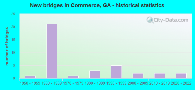
- New bridges - historical statistics
- 11950-1959
- 211960-1969
- 11970-1979
- 31980-1989
- 51990-1999
- 22000-2009
- 22010-2019
- 22020-2022

- Reconstructed bridges - Historical Statistics
- 61970-1979
- 41980-1989
- 11990-1999


- Bridge Condition - Deck
- 20.0%Very good
- 50.0%Good
- 25.0%Satisfactory
- 5.0%Fair

- Bridge Condition - Superstructure
- 25.0%Very good
- 45.0%Good
- 25.0%Satisfactory
- 5.0%Fair

- Bridge Condition - Substructure
- 15.0%Very good
- 55.0%Good
- 30.0%Satisfactory

- Bridge Condition - Channel
- 3.4%Excellent
- 20.7%Very good
- 13.8%Good
- 31.0%Satisfactory
- 31.0%Fair

- Bridge Condition - Culverts
- 5.9%Very good
- 52.9%Good
- 41.2%Satisfactory
Find on map >> Show street view
Structure Number: 110025, Location: 5.9 MI S OF HOMER (Lat: 34.252919, Lng: -83.466578), Route carried "on" structure: Interstate 85, Year Built: 1964, Status: Open, Structure Length: 0.73m (2.40ft), Average Daily Traffic: 43,470 (year 2012), Truck Traffic: 1%, Average Future Daily Traffic: 65,205 (year 2032), Design Load: HS 20+Mod, Features Intersected: CROOKED CREEK
Minimum Vertical Clearance: 30+ m (98+ ft), Kilometerpoint: 239.792, Lanes on structure: 6, Base Highway Network: Yes, Owner: State Highway Agency, Approaching Roadway Width: 36.0m (118.1ft), Skew: 13 degrees, Material/Design: Concrete, Design/Construction: Culvert, Number Of Spans In Main Unit: 2, Length of Maximum Span: 3.7m (12.1ft)
Condition: Channel: Fair, Culverts: Good, Operating Rating: 55.3 metric tons, Method Used To Determine Operating Rating: Load Factor (LF), Inventory Rating: 32.6 metric tons, Method Used To Determine Inventory Rating: Load Factor (LF), Structural Evaluation: Better than present minimum criteria, Waterway Adequacy: Superior to present desirable criteria, Approach Roadway Alignment: Equal to present desirable criteria, Designated Inspection Frequency: Every 24 months, Inspection Date: September 2021, Bridge Improvement Cost: $196,000, Roadway Improvement Cost: $20,000, Total Project Cost: $294,000
Find on map >> Show street view
Structure Number: 110026, Location: 5.9 MI S OF HOMER (Lat: 34.257258, Lng: -83.458828), Route carried "on" structure: Interstate 85, Year Built: 1964, Status: Open, Structure Length: 1.34m (4.40ft), Average Daily Traffic: 41,240 (year 2012), Truck Traffic: 1%, Average Future Daily Traffic: 61,860 (year 2032), Design Load: HS 20+Mod, Features Intersected: CROOKED CREEK
Minimum Vertical Clearance: 30+ m (98+ ft), Kilometerpoint: 241.402, Lanes on structure: 5, Base Highway Network: Yes, Owner: State Highway Agency, Approaching Roadway Width: 30.2m (99.1ft), Skew: 10 degrees, Material/Design: Concrete, Design/Construction: Culvert, Number Of Spans In Main Unit: 4, Length of Maximum Span: 3.0m (9.8ft)
Condition: Channel: Satisfactory, Culverts: Good, Operating Rating: 55.3 metric tons, Method Used To Determine Operating Rating: Load Factor (LF), Inventory Rating: 32.6 metric tons, Method Used To Determine Inventory Rating: Load Factor (LF), Structural Evaluation: Better than present minimum criteria, Waterway Adequacy: Superior to present desirable criteria, Approach Roadway Alignment: Equal to present desirable criteria, Designated Inspection Frequency: Every 24 months, Inspection Date: August 2021, Bridge Improvement Cost: $313,000, Roadway Improvement Cost: $31,000, Total Project Cost: $469,000
Find on map >> Show street view
Structure Number: 110027, Location: 5.9 MI S OF HOMER (Lat: 34.261897, Lng: -83.450597), Route carried "on" structure: Interstate 85, Year Built: 1963, Year Reconstructed: 1981, Status: Open, Structure Length: 6.22m (20.41ft), Average Daily Traffic: 41,240 (year 2012), Truck Traffic: 1%, Average Future Daily Traffic: 61,860 (year 2032), Design Load: HS 20+Mod, Features Intersected: GROVE CREEK
Minimum Vertical Clearance: 30+ m (98+ ft), Kilometerpoint: 241.402, Lanes on structure: 2, Base Highway Network: Yes, Owner: State Highway Agency, Approaching Roadway Width: 11.3m (37.1ft), Skew: 10 degrees, Material/Design: Concrete, Design/Construction: Tee Beam, Number Of Spans In Main Unit: 6, Length of Maximum Span: 10.4m (34.1ft), Curb-To-Curb Width: 12.8m (42.0ft), Out-to-Out Width: 13.7m (44.9ft)
Condition: Deck: Good, Superstructure: Good, Substructure: Good, Channel: Satisfactory, Operating Rating: 55.3 metric tons, Method Used To Determine Operating Rating: Load Factor (LF), Inventory Rating: 32.6 metric tons, Method Used To Determine Inventory Rating: Load Factor (LF), Structural Evaluation: Better than present minimum criteria, Deck Geometry: Equal to present desirable criteria, Waterway Adequacy: Superior to present desirable criteria, Approach Roadway Alignment: Better than present minimum criteria, Designated Inspection Frequency: Every 24 months, Inspection Date: September 2021, Bridge Improvement Cost: $797,000, Roadway Improvement Cost: $80,000, Total Project Cost: $1,196,000, Deck Structure Type: Concrete Cast-file-Place, Wearing Surface/Protective System: Wearing Surface: Epoxy Overlay
Find on map >> Show street view
Structure Number: 110028, Location: 5.9 MI S OF HOMER (Lat: 34.262339, Lng: -83.451128), Route carried "on" structure: Interstate 85, Year Built: 1963, Year Reconstructed: 1981, Status: Open, Structure Length: 6.22m (20.41ft), Average Daily Traffic: 41,240 (year 2012), Truck Traffic: 1%, Average Future Daily Traffic: 61,860 (year 2032), Design Load: HS 20+Mod, Features Intersected: GROVE CREEK
Minimum Vertical Clearance: 30+ m (98+ ft), Kilometerpoint: 241.402, Lanes on structure: 2, Base Highway Network: Yes, Owner: State Highway Agency, Approaching Roadway Width: 11.3m (37.1ft), Skew: 10 degrees, Material/Design: Concrete, Design/Construction: Tee Beam, Number Of Spans In Main Unit: 6, Length of Maximum Span: 10.4m (34.1ft), Curb-To-Curb Width: 12.8m (42.0ft), Out-to-Out Width: 13.7m (44.9ft)
Condition: Deck: Good, Superstructure: Good, Substructure: Good, Channel: Satisfactory, Operating Rating: 41.7 metric tons, Method Used To Determine Operating Rating: Load Factor (LF), Inventory Rating: 24.4 metric tons, Method Used To Determine Inventory Rating: Load Factor (LF), Structural Evaluation: Equal to present minimum criteria, Deck Geometry: Equal to present desirable criteria, Waterway Adequacy: Superior to present desirable criteria, Approach Roadway Alignment: Better than present minimum criteria, Designated Inspection Frequency: Every 24 months, Inspection Date: September 2021, Bridge Improvement Cost: $797,000, Roadway Improvement Cost: $80,000, Total Project Cost: $1,196,000, Deck Structure Type: Concrete Cast-file-Place, Wearing Surface/Protective System: Wearing Surface: Epoxy Overlay
Find on map >> Show street view
Structure Number: 110029, Location: 5.6 MI S OF HOMER (Lat: 34.264189, Lng: -83.447569), Route carried "on" structure: Interstate 85, Year Built: 1963, Year Reconstructed: 1981, Status: Open, Structure Length: 4.02m (13.19ft), Average Daily Traffic: 41,240 (year 2012), Truck Traffic: 1%, Average Future Daily Traffic: 61,860 (year 2032), Design Load: HS 20+Mod, Features Intersected: HARDEN BRIDGE RD
Minimum Vertical Clearance: 30+ m (98+ ft), Kilometerpoint: 241.402, Lanes on structure: 2, Lanes under structure: 2, Base Highway Network: Yes, Owner: State Highway Agency, Approaching Roadway Width: 11.3m (37.1ft), Skew: 11 degrees, Material/Design: Steel, Design/Construction: Stringer/Multi-beam, Number Of Spans In Main Unit: 3, Length of Maximum Span: 13.4m (44.0ft), Curb-To-Curb Width: 11.2m (36.7ft), Out-to-Out Width: 11.9m (39.0ft)
Condition: Deck: Good, Superstructure: Good, Substructure: Good, Operating Rating: 51.7 metric tons, Method Used To Determine Operating Rating: Load Factor (LF), Inventory Rating: 30.8 metric tons, Method Used To Determine Inventory Rating: Load Factor (LF), Structural Evaluation: Better than present minimum criteria, Deck Geometry: Somewhat better than minimum adequacy, Underclear: Meets minimum limits, Approach Roadway Alignment: Equal to present desirable criteria, Designated Inspection Frequency: Every 24 months, Inspection Date: September 2021, Bridge Improvement Cost: $516,000, Roadway Improvement Cost: $52,000, Total Project Cost: $774,000, Deck Structure Type: Concrete Cast-file-Place
Find on map >> Show street view
Structure Number: 11003, Location: 5.6 MI S OF HOMER (Lat: 34.264728, Lng: -83.447958), Route carried "on" structure: Interstate 85, Year Built: 1963, Year Reconstructed: 1981, Status: Open, Structure Length: 4.02m (13.19ft), Average Daily Traffic: 41,240 (year 2012), Truck Traffic: 1%, Average Future Daily Traffic: 61,860 (year 2032), Design Load: HS 20+Mod, Features Intersected: HARDEN BRIDGE RD
Minimum Vertical Clearance: 30+ m (98+ ft), Kilometerpoint: 241.402, Lanes on structure: 2, Lanes under structure: 2, Base Highway Network: Yes, Owner: State Highway Agency, Approaching Roadway Width: 11.0m (36.1ft), Skew: 11 degrees, Material/Design: Steel, Design/Construction: Stringer/Multi-beam, Number Of Spans In Main Unit: 3, Length of Maximum Span: 13.4m (44.0ft), Curb-To-Curb Width: 11.2m (36.7ft), Out-to-Out Width: 11.9m (39.0ft)
Condition: Deck: Good, Superstructure: Good, Substructure: Good, Operating Rating: 51.7 metric tons, Method Used To Determine Operating Rating: Load Factor (LF), Inventory Rating: 30.8 metric tons, Method Used To Determine Inventory Rating: Load Factor (LF), Structural Evaluation: Better than present minimum criteria, Deck Geometry: Somewhat better than minimum adequacy, Underclear: Meets minimum limits, Approach Roadway Alignment: Equal to present desirable criteria, Designated Inspection Frequency: Every 24 months, Inspection Date: September 2021, Bridge Improvement Cost: $516,000, Roadway Improvement Cost: $52,000, Total Project Cost: $774,000, Deck Structure Type: Concrete Cast-file-Place, Wearing Surface/Protective System: Wearing Surface: Epoxy Overlay
Find on map >> Show street view
Structure Number: 110031, Location: 5 MI SE OF HOMER (Lat: 34.281889, Lng: -83.429119), Route carried "on" structure: Interstate 85, Year Built: 1963, Year Reconstructed: 1981, Status: Open, Structure Length: 4.60m (15.09ft), Average Daily Traffic: 41,240 (year 2012), Truck Traffic: 1%, Average Future Daily Traffic: 61,860 (year 2032), Design Load: HS 20+Mod, Features Intersected: SR 164
Minimum Vertical Clearance: 30+ m (98+ ft), Kilometerpoint: 246.230, Lanes on structure: 2, Lanes under structure: 2, Base Highway Network: Yes, Owner: State Highway Agency, Approaching Roadway Width: 11.3m (37.1ft), Skew: 12 degrees, Material/Design: Steel continuous, Design/Construction: Stringer/Multi-beam, Number Of Spans In Main Unit: 3, Length of Maximum Span: 18.6m (61.0ft), Curb-To-Curb Width: 12.7m (41.7ft), Out-to-Out Width: 13.7m (44.9ft)
Condition: Deck: Fair, Superstructure: Fair, Substructure: Good, Operating Rating: 32.6 metric tons, Method Used To Determine Operating Rating: Load Factor (LF), Inventory Rating: 19.9 metric tons, Method Used To Determine Inventory Rating: Load Factor (LF), Structural Evaluation: Somewhat better than minimum adequacy, Deck Geometry: Better than present minimum criteria, Underclear: Better than present minimum criteria, Approach Roadway Alignment: Equal to present desirable criteria, Designated Inspection Frequency: Every 24 months, Inspection Date: September 2021, Bridge Improvement Cost: $590,000, Roadway Improvement Cost: $59,000, Total Project Cost: $885,000, Deck Structure Type: Concrete Cast-file-Place, Wearing Surface/Protective System: Wearing Surface: Epoxy Overlay
Find on map >> Show street view
Structure Number: 110032, Location: 5 MI SE OF HOMER (Lat: 34.281969, Lng: -83.429908), Route carried "on" structure: Interstate 85, Year Built: 1963, Year Reconstructed: 1981, Status: Open, Structure Length: 4.60m (15.09ft), Average Daily Traffic: 1,770 (year 2012), Truck Traffic: 1%, Average Future Daily Traffic: 2,655 (year 2032), Design Load: HS 20+Mod, Features Intersected: SR 164
Minimum Vertical Clearance: 30+ m (98+ ft), Kilometerpoint: 246.230, Lanes on structure: 2, Lanes under structure: 2, Base Highway Network: Yes, Owner: State Highway Agency, Approaching Roadway Width: 11.0m (36.1ft), Skew: 13 degrees, Material/Design: Steel continuous, Design/Construction: Stringer/Multi-beam, Number Of Spans In Main Unit: 3, Length of Maximum Span: 18.6m (61.0ft), Curb-To-Curb Width: 12.8m (42.0ft), Out-to-Out Width: 13.7m (44.9ft)
Condition: Deck: Satisfactory, Superstructure: Satisfactory, Substructure: Good, Operating Rating: 33.5 metric tons, Method Used To Determine Operating Rating: Load Factor (LF), Inventory Rating: 19.9 metric tons, Method Used To Determine Inventory Rating: Load Factor (LF), Structural Evaluation: Somewhat better than minimum adequacy, Deck Geometry: Equal to present desirable criteria, Underclear: Equal to present minimum criteria, Approach Roadway Alignment: Equal to present desirable criteria, Designated Inspection Frequency: Every 24 months, Inspection Date: September 2021, Bridge Improvement Cost: $590,000, Roadway Improvement Cost: $59,000, Total Project Cost: $885,000, Deck Structure Type: Concrete Cast-file-Place, Wearing Surface/Protective System: Wearing Surface: Epoxy Overlay
Find on map >> Show street view
Structure Number: 115042, Location: 8.1 MI SE OF HOMER (Lat: 34.247578, Lng: -83.403750), Route carried "on" structure: County highway 227, Year Built: 1967, Status: Posted for load, Structure Length: 3.66m (12.01ft), Average Daily Traffic: 490 (year 2012), Truck Traffic: 1%, Average Future Daily Traffic: 735 (year 2032), Design Load: H 15, Features Intersected: BEAVERDAM CREEK, Facility Carried by Structure: BROWN BRIDGE ROAD
Minimum Vertical Clearance: 30+ m (98+ ft), Kilometerpoint: 1.609, Lanes on structure: 2, Base Highway Network: Yes, Owner: County Highway Agency, Approaching Roadway Width: 6.4m (21.0ft), Material/Design: Concrete, Design/Construction: Tee Beam, Number Of Spans In Main Unit: 3, Length of Maximum Span: 12.2m (40.0ft), Curb or Sidewalk Widths: Left: 0.6m (2.0ft), Right: 0.6m (2.0ft), Curb-To-Curb Width: 7.3m (24.0ft), Out-to-Out Width: 9.1m (29.9ft)
Condition: Deck: Good, Superstructure: Good, Substructure: Good, Channel: Satisfactory, Operating Rating: 27.2 metric tons, Method Used To Determine Operating Rating: Load Factor (LF), Inventory Rating: 16.3 metric tons, Method Used To Determine Inventory Rating: Load Factor (LF), Structural Evaluation: Somewhat better than minimum adequacy, Deck Geometry: Meets minimum limits, Waterway Adequacy: Equal to present desirable criteria, Approach Roadway Alignment: Equal to present minimum criteria, Bridge Posting: Required (Relationship of Operating Rating to Maximum Legal Load: 10.0 - 19.9% below), Designated Inspection Frequency: Every 24 months, Inspection Date: August 2021, Bridge Improvement Cost: $469,000, Roadway Improvement Cost: $47,000, Total Project Cost: $703,000, Deck Structure Type: Concrete Cast-file-Place
Find on map >> Show street view
Structure Number: 11505, Location: 4.8 MI SE OF HOMER (Lat: 34.269089, Lng: -83.468000), Route carried "on" structure: US 441, Year Built: 1997, Status: Open, Structure Length: 8.11m (26.61ft), Average Daily Traffic: 10,920 (year 2012), Truck Traffic: 8%, Average Future Daily Traffic: 16,380 (year 2032), Design Load: HS 20+Mod, Features Intersected: GROVE CREEK
Minimum Vertical Clearance: 30+ m (98+ ft), Kilometerpoint: 3.219, Lanes on structure: 2, Base Highway Network: Yes, Owner: State Highway Agency, Approaching Roadway Width: 9.1m (29.9ft), Skew: 10 degrees, Material/Design: Prestressed concrete, Design/Construction: Stringer/Multi-beam, Number Of Spans In Main Unit: 5, Length of Maximum Span: 23.2m (76.1ft), Curb-To-Curb Width: 11.5m (37.7ft), Out-to-Out Width: 12.5m (41.0ft)
Condition: Deck: Good, Superstructure: Good, Substructure: Good, Channel: Fair, Operating Rating: 49.8 metric tons, Method Used To Determine Operating Rating: Load Factor (LF), Inventory Rating: 28.1 metric tons, Method Used To Determine Inventory Rating: Load Factor (LF), Structural Evaluation: Better than present minimum criteria, Deck Geometry: Equal to present minimum criteria, Waterway Adequacy: Equal to present desirable criteria, Approach Roadway Alignment: Equal to present minimum criteria, Designated Inspection Frequency: Every 24 months, Inspection Date: August 2021, Bridge Improvement Cost: $1,039,000, Roadway Improvement Cost: $104,000, Total Project Cost: $1,559,000, Deck Structure Type: Concrete Cast-file-Place
Find on map >> Show street view
Structure Number: 115073, Location: 6.5 MI SE OF HOMER (Lat: 34.266358, Lng: -83.425558), Route carried "on" structure: State highway 59, Year Built: 2018, Status: Open, Structure Length: 7.77m (25.49ft), Average Daily Traffic: 3,400 (year 2017), Truck Traffic: 1%, Average Future Daily Traffic: 5,500 (year 2039), Design Load: HL 93, Features Intersected: GROVE CREEK
Minimum Vertical Clearance: 30+ m (98+ ft), Kilometerpoint: 4.828, Lanes on structure: 2, Base Highway Network: Yes, Owner: State Highway Agency, Approaching Roadway Width: 12.2m (40.0ft), Material/Design: Prestressed concrete, Design/Construction: Stringer/Multi-beam, Number Of Spans In Main Unit: 3, Length of Maximum Span: 32.0m (105.0ft), Curb-To-Curb Width: 12.2m (40.0ft), Out-to-Out Width: 13.1m (43.0ft)
Condition: Deck: Very good, Superstructure: Very good, Substructure: Good, Channel: Very good, Operating Rating: 66.2 metric tons, Method Used To Determine Operating Rating: Load Factor (LF), Inventory Rating: 38.1 metric tons, Method Used To Determine Inventory Rating: Load Factor (LF), Structural Evaluation: Better than present minimum criteria, Deck Geometry: Equal to present minimum criteria, Waterway Adequacy: Superior to present desirable criteria, Approach Roadway Alignment: Equal to present desirable criteria, Length Of Structure Improvement: 9.33m (30.61ft), Designated Inspection Frequency: Every 24 months, Inspection Date: August 2021, Bridge Improvement Cost: $22,644,000, Roadway Improvement Cost: $2,264,000, Total Project Cost: $33,966,000 ( Estimate for 2018), Deck Structure Type: Concrete Cast-file-Place
Find on map >> Show street view
Structure Number: 115075, Location: 3.4 MI N OF COMMERCE (Lat: 34.253289, Lng: -83.468069), Route carried "on" structure: County highway 328, Year Built: 2021, Status: Open, Structure Length: 1.01m (3.31ft), Average Daily Traffic: 490 (year 2012), Truck Traffic: 1%, Average Future Daily Traffic: 735 (year 2032), Design Load: HL 93, Features Intersected: GROVE CREEK, Facility Carried by Structure: STEVEN B. TANGER B
Minimum Vertical Clearance: 30+ m (98+ ft), Kilometerpoint: 0.000, Lanes on structure: 2, Base Highway Network: Yes, Owner: County Highway Agency, Approaching Roadway Width: 9.4m (30.8ft), Skew: 2 degrees, Material/Design: Concrete, Design/Construction: Culvert, Number Of Spans In Main Unit: 3, Length of Maximum Span: 2.7m (8.9ft)
Condition: Channel: Very good, Culverts: Very good, Operating Rating: 82.5 metric tons, Method Used To Determine Operating Rating: Load Factor (LF), Inventory Rating: 49.8 metric tons, Method Used To Determine Inventory Rating: Load Factor (LF), Structural Evaluation: Equal to present desirable criteria, Waterway Adequacy: Equal to present desirable criteria, Approach Roadway Alignment: Equal to present desirable criteria, Designated Inspection Frequency: Every 24 months, Inspection Date: August 2021
Find on map >> Show street view
Structure Number: 115076, Location: 4.8 MI SE OF HOMER (Lat: 34.269219, Lng: -83.468239), Route carried "on" structure: US 441, Year Built: 2022, Status: Open, Structure Length: 8.99m (29.49ft), Average Daily Traffic: 15,600 (year 2022), Truck Traffic: 9%, Average Future Daily Traffic: 20,970 (year 2042), Design Load: HL 93, Features Intersected: GROVE CREEK
Minimum Vertical Clearance: 30+ m (98+ ft), Kilometerpoint: 3.219, Lanes on structure: 2, Base Highway Network: Yes, Owner: State Highway Agency, Approaching Roadway Width: 11.6m (38.1ft), Material/Design: Concrete, Design/Construction: Stringer/Multi-beam, Number Of Spans In Main Unit: 3, Length of Maximum Span: 36.6m (120.1ft), Curb-To-Curb Width: 11.6m (38.1ft), Out-to-Out Width: 12.5m (41.0ft)
Condition: Deck: Very good, Superstructure: Very good, Substructure: Very good, Channel: Excellent, Operating Rating: 66.2 metric tons, Method Used To Determine Operating Rating: Load Factor (LF), Inventory Rating: 39.9 metric tons, Method Used To Determine Inventory Rating: Load Factor (LF), Structural Evaluation: Equal to present desirable criteria, Deck Geometry: Better than present minimum criteria, Waterway Adequacy: Equal to present desirable criteria, Approach Roadway Alignment: Equal to present desirable criteria, Length Of Structure Improvement: 10.79m (35.40ft), Designated Inspection Frequency: Every 24 months, Inspection Date: Febuary 2022, Bridge Improvement Cost: $26,196,000, Roadway Improvement Cost: $2,620,000, Total Project Cost: $39,294,000 ( Estimate for 2022), Deck Structure Type: Concrete Cast-file-Place
Find on map >> Show street view
Structure Number: 157001, Location: 4 MI NE OF JEFFERSON (Lat: 34.152808, Lng: -83.518728), Route carried "on" structure: Alternate State highway 15, Year Built: 1960, Status: Open, Structure Length: 1.01m (3.31ft), Average Daily Traffic: 4,540 (year 2012), Truck Traffic: 1%, Average Future Daily Traffic: 6,810 (year 2032), Design Load: HS 20+Mod, Features Intersected: PARKS CREEK
Minimum Vertical Clearance: 30+ m (98+ ft), Kilometerpoint: 27.359, Lanes on structure: 2, Base Highway Network: Yes, Owner: State Highway Agency, Approaching Roadway Width: 7.6m (24.9ft), Skew: 1 degrees, Material/Design: Concrete, Design/Construction: Culvert, Number Of Spans In Main Unit: 3, Length of Maximum Span: 3.0m (9.8ft)
Condition: Channel: Very good, Culverts: Satisfactory, Operating Rating: 59.8 metric tons, Method Used To Determine Operating Rating: Load Factor (LF), Inventory Rating: 36.2 metric tons, Method Used To Determine Inventory Rating: Load Factor (LF), Structural Evaluation: Equal to present minimum criteria, Waterway Adequacy: Equal to present desirable criteria, Approach Roadway Alignment: Equal to present minimum criteria, Designated Inspection Frequency: Every 24 months, Underwater Inspection Frequency: Every 60 months, Inspection Date: September 2020, Underwater Inspection Date: June 2021, Bridge Improvement Cost: $129,000, Roadway Improvement Cost: $13,000, Total Project Cost: $193,000
Find on map >> Show street view
Structure Number: 1570011, Location: 5.7 MI NE OF JEFFERSON (Lat: 34.169297, Lng: -83.496778), Route carried "on" structure: Alternate State highway 15, Year Built: 1967, Status: Open, Structure Length: 5.61m (18.41ft), Average Daily Traffic: 3,960 (year 2012), Truck Traffic: 1%, Average Future Daily Traffic: 5,940 (year 2032), Design Load: HS 20+Mod, Features Intersected: NORTH OCONEE RIVER
Minimum Vertical Clearance: 30+ m (98+ ft), Kilometerpoint: 28.968, Lanes on structure: 2, Base Highway Network: Yes, Owner: State Highway Agency, Approaching Roadway Width: 7.6m (24.9ft), Skew: 1 degrees, Material/Design: Concrete, Design/Construction: Tee Beam, Number Of Spans In Main Unit: 5, Length of Maximum Span: 12.2m (40.0ft), Curb or Sidewalk Widths: Left: 0.5m (1.6ft), Right: 0.5m (1.6ft), Curb-To-Curb Width: 8.5m (27.9ft), Out-to-Out Width: 10.3m (33.8ft)
Condition: Deck: Good, Superstructure: Good, Substructure: Satisfactory, Channel: Good, Operating Rating: 33.5 metric tons, Method Used To Determine Operating Rating: Load Factor (LF), Inventory Rating: 16.3 metric tons, Method Used To Determine Inventory Rating: Load Factor (LF), Structural Evaluation: Meets minimum limits, Deck Geometry: Meets minimum limits, Waterway Adequacy: Equal to present desirable criteria, Approach Roadway Alignment: Equal to present desirable criteria, Designated Inspection Frequency: Every 24 months, Underwater Inspection Frequency: Every 60 months, Inspection Date: September 2020, Underwater Inspection Date: June 2021, Bridge Improvement Cost: $719,000, Roadway Improvement Cost: $72,000, Total Project Cost: $1,078,000, Deck Structure Type: Concrete Cast-file-Place
Find on map >> Show street view
Structure Number: 1570012, Location: 2.1 MI SW OF COMMERCE (Lat: 34.182128, Lng: -83.482778), Route carried "on" structure: Alternate State highway 15, Year Built: 1961, Status: Open, Structure Length: 0.91m (2.99ft), Average Daily Traffic: 3,850 (year 2011), Truck Traffic: 1%, Average Future Daily Traffic: 5,775 (year 2031), Design Load: HS 20+Mod, Features Intersected: BORDERS CREEK
Minimum Vertical Clearance: 30+ m (98+ ft), Kilometerpoint: 32.187, Lanes on structure: 2, Base Highway Network: Yes, Owner: State Highway Agency, Approaching Roadway Width: 8.5m (27.9ft), Skew: 4 degrees, Material/Design: Concrete, Design/Construction: Culvert, Number Of Spans In Main Unit: 2, Length of Maximum Span: 4.3m (14.1ft)
Condition: Channel: Satisfactory, Culverts: Satisfactory, Operating Rating: 59.8 metric tons, Method Used To Determine Operating Rating: Load Factor (LF), Inventory Rating: 36.2 metric tons, Method Used To Determine Inventory Rating: Load Factor (LF), Structural Evaluation: Equal to present minimum criteria, Waterway Adequacy: Superior to present desirable criteria, Approach Roadway Alignment: Somewhat better than minimum adequacy, Designated Inspection Frequency: Every 24 months, Inspection Date: September 2020, Bridge Improvement Cost: $117,000, Roadway Improvement Cost: $12,000, Total Project Cost: $176,000
Find on map >> Show street view
Structure Number: 1570017, Location: 6.3 MI N OF JEFFERSON (Lat: 34.205819, Lng: -83.552400), Route carried "on" structure: Spur State highway 82, Year Built: 1963, Status: Open, Structure Length: 8.41m (27.59ft), Average Daily Traffic: 1,980 (year 2011), Truck Traffic: 9%, Average Future Daily Traffic: 2,970 (year 2031), Design Load: HS 20+Mod, Features Intersected: I-85 (SR 403)
Minimum Vertical Clearance: 30+ m (98+ ft), Kilometerpoint: 3.219, Lanes on structure: 2, Lanes under structure: 4, Base Highway Network: Yes, Owner: State Highway Agency, Approaching Roadway Width: 7.3m (24.0ft), Skew: 2 degrees, Material/Design: Steel continuous, Design/Construction: Stringer/Multi-beam, Number Of Spans In Main Unit: 4, Length of Maximum Span: 23.2m (76.1ft), Curb or Sidewalk Widths: Left: 0.6m (2.0ft), Right: 0.6m (2.0ft), Curb-To-Curb Width: 8.5m (27.9ft), Out-to-Out Width: 10.4m (34.1ft)
Condition: Deck: Good, Superstructure: Good, Substructure: Good, Operating Rating: 32.6 metric tons, Method Used To Determine Operating Rating: Load Factor (LF), Inventory Rating: 19.0 metric tons, Method Used To Determine Inventory Rating: Load Factor (LF), Structural Evaluation: Somewhat better than minimum adequacy, Deck Geometry: Somewhat better than minimum adequacy, Underclear: Equal to present minimum criteria, Approach Roadway Alignment: Better than present minimum criteria, Designated Inspection Frequency: Every 24 months, Inspection Date: December 2020, Bridge Improvement Cost: $1,078,000, Roadway Improvement Cost: $108,000, Total Project Cost: $1,618,000, Deck Structure Type: Concrete Cast-file-Place
Find on map >> Show street view
Structure Number: 1570024, Location: 1.5 MI NE OF COMMERCE (Lat: 34.214908, Lng: -83.435739), Route carried "on" structure: State highway 326, Year Built: 1950, Status: Open, Structure Length: 1.01m (3.31ft), Average Daily Traffic: 1,390 (year 2011), Truck Traffic: 8%, Average Future Daily Traffic: 2,085 (year 2031), Design Load: H 15, Features Intersected: BEAVER DAM CREEK
Minimum Vertical Clearance: 30+ m (98+ ft), Kilometerpoint: 6.437, Lanes on structure: 2, Base Highway Network: Yes, Owner: State Highway Agency, Approaching Roadway Width: 8.5m (27.9ft), Skew: 1 degrees, Material/Design: Concrete, Design/Construction: Culvert, Number Of Spans In Main Unit: 3, Length of Maximum Span: 3.0m (9.8ft)
Condition: Channel: Fair, Culverts: Good, Operating Rating: 41.7 metric tons, Method Used To Determine Operating Rating: Field evaluation and documented engineering judgment, Inventory Rating: 24.4 metric tons, Method Used To Determine Inventory Rating: Field evaluation and documented engineering judgment, Structural Evaluation: Equal to present minimum criteria, Waterway Adequacy: Superior to present desirable criteria, Approach Roadway Alignment: Equal to present minimum criteria, Designated Inspection Frequency: Every 24 months, Inspection Date: October 2020, Bridge Improvement Cost: $129,000, Roadway Improvement Cost: $13,000, Total Project Cost: $193,000
Find on map >> Show street view
Structure Number: 1570045, Location: 4.4 MI NW OF COMMERCE (Lat: 34.212406, Lng: -83.532394), Route carried "on" structure: Interstate 85, Year Built: 1963, Year Reconstructed: 1985, Status: Open, Structure Length: 9.75m (31.99ft), Average Daily Traffic: 46,000 (year 2011), Truck Traffic: 1%, Average Future Daily Traffic: 69,000 (year 2031), Design Load: HS 20+Mod, Features Intersected: NORTH OCONEE RIVER
Minimum Vertical Clearance: 30+ m (98+ ft), Kilometerpoint: 231.746, Lanes on structure: 2, Base Highway Network: Yes, Owner: State Highway Agency, Approaching Roadway Width: 11.6m (38.1ft), Skew: 10 degrees, Material/Design: Steel, Design/Construction: Stringer/Multi-beam, Number Of Spans In Main Unit: 5, Length of Maximum Span: 19.5m (64.0ft), Curb-To-Curb Width: 12.8m (42.0ft), Out-to-Out Width: 13.8m (45.3ft)
Condition: Deck: Satisfactory, Superstructure: Satisfactory, Substructure: Satisfactory, Channel: Satisfactory, Operating Rating: 34.4 metric tons, Method Used To Determine Operating Rating: Load Factor (LF), Inventory Rating: 20.8 metric tons, Method Used To Determine Inventory Rating: Load Factor (LF), Structural Evaluation: Somewhat better than minimum adequacy, Deck Geometry: Equal to present desirable criteria, Waterway Adequacy: Superior to present desirable criteria, Approach Roadway Alignment: Better than present minimum criteria, Designated Inspection Frequency: Every 24 months, Other Special Inspection Frequency: Every 24 months, Inspection Date: November 2020, Other Special Inspection Date: November 2021, Bridge Improvement Cost: $1,250,000, Roadway Improvement Cost: $125,000, Total Project Cost: $1,875,000, Deck Structure Type: Concrete Cast-file-Place
Find on map >> Show street view
Structure Number: 1570046, Location: 4.4 MI NW OF COMMERCE (Lat: 34.212622, Lng: -83.532561), Route carried "on" structure: Interstate 85, Year Built: 1963, Year Reconstructed: 1985, Status: Open, Structure Length: 9.75m (31.99ft), Average Daily Traffic: 46,000 (year 2011), Truck Traffic: 1%, Average Future Daily Traffic: 69,000 (year 2031), Design Load: HS 20+Mod, Features Intersected: NORTH OCONEE RIVER
Minimum Vertical Clearance: 30+ m (98+ ft), Kilometerpoint: 231.746, Lanes on structure: 2, Base Highway Network: Yes, Owner: State Highway Agency, Approaching Roadway Width: 11.6m (38.1ft), Skew: 10 degrees, Material/Design: Steel, Design/Construction: Stringer/Multi-beam, Number Of Spans In Main Unit: 5, Length of Maximum Span: 19.5m (64.0ft), Curb-To-Curb Width: 12.7m (41.7ft), Out-to-Out Width: 13.8m (45.3ft)
Condition: Deck: Satisfactory, Superstructure: Satisfactory, Substructure: Satisfactory, Channel: Satisfactory, Operating Rating: 35.3 metric tons, Method Used To Determine Operating Rating: Load Factor (LF), Inventory Rating: 20.8 metric tons, Method Used To Determine Inventory Rating: Load Factor (LF), Structural Evaluation: Somewhat better than minimum adequacy, Deck Geometry: Better than present minimum criteria, Waterway Adequacy: Superior to present desirable criteria, Approach Roadway Alignment: Better than present minimum criteria, Designated Inspection Frequency: Every 24 months, Inspection Date: November 2020, Bridge Improvement Cost: $1,250,000, Roadway Improvement Cost: $125,000, Total Project Cost: $1,875,000, Deck Structure Type: Concrete Cast-file-Place
Find on map >> Show street view
Structure Number: 1570047, Location: 3.9 MI NW OF COMMERCE (Lat: 34.219528, Lng: -83.521069), Route carried "on" structure: Interstate 85, Year Built: 1963, Status: Open, Structure Length: 0.67m (2.20ft), Average Daily Traffic: 46,000 (year 2011), Truck Traffic: 1%, Average Future Daily Traffic: 69,000 (year 2031), Design Load: HS 20+Mod, Features Intersected: GRAVELLY CREEK
Minimum Vertical Clearance: 30+ m (98+ ft), Kilometerpoint: 233.355, Lanes on structure: 4, Base Highway Network: Yes, Owner: State Highway Agency, Approaching Roadway Width: 23.5m (77.1ft), Skew: 11 degrees, Material/Design: Concrete, Design/Construction: Culvert, Number Of Spans In Main Unit: 2, Length of Maximum Span: 3.4m (11.2ft)
Condition: Channel: Fair, Culverts: Good, Structural Evaluation: Better than present minimum criteria, Waterway Adequacy: Superior to present desirable criteria, Approach Roadway Alignment: Equal to present desirable criteria, Designated Inspection Frequency: Every 24 months, Inspection Date: November 2020, Bridge Improvement Cost: $133,000, Roadway Improvement Cost: $13,000, Total Project Cost: $199,000
Find on map >> Show street view
Structure Number: 1570048, Location: 3.3 MI N OF COMMERCE (Lat: 34.244164, Lng: -83.480675), Route carried "on" structure: Interstate 85, Year Built: 1963, Year Reconstructed: 1985, Status: Open, Structure Length: 3.20m (10.50ft), Average Daily Traffic: 43,340 (year 2011), Truck Traffic: 1%, Average Future Daily Traffic: 65,010 (year 2031), Design Load: HS 20+Mod, Features Intersected: CR 296 RIDGEWAY CH ROAD
Minimum Vertical Clearance: 30+ m (98+ ft), Kilometerpoint: 238.183, Lanes on structure: 2, Lanes under structure: 2, Base Highway Network: Yes, Owner: State Highway Agency, Approaching Roadway Width: 11.6m (38.1ft), Skew: 10 degrees, Material/Design: Concrete, Design/Construction: Tee Beam, Number Of Spans In Main Unit: 3, Length of Maximum Span: 11.6m (38.1ft), Curb-To-Curb Width: 12.8m (42.0ft), Out-to-Out Width: 13.8m (45.3ft)
Condition: Deck: Satisfactory, Superstructure: Satisfactory, Substructure: Satisfactory, Operating Rating: 33.5 metric tons, Method Used To Determine Operating Rating: Load Factor (LF), Inventory Rating: 19.9 metric tons, Method Used To Determine Inventory Rating: Load Factor (LF), Structural Evaluation: Somewhat better than minimum adequacy, Deck Geometry: Equal to present desirable criteria, Underclear: Meets minimum limits, Approach Roadway Alignment: Equal to present desirable criteria, Designated Inspection Frequency: Every 24 months, Inspection Date: December 2020, Bridge Improvement Cost: $410,000, Roadway Improvement Cost: $41,000, Total Project Cost: $615,000, Deck Structure Type: Concrete Cast-file-Place
Find on map >> Show street view
Structure Number: 1570049, Location: 3.3 MI N OF COMMERCE (Lat: 34.244372, Lng: -83.480881), Route carried "on" structure: Interstate 85, Year Built: 1963, Year Reconstructed: 1985, Status: Open, Structure Length: 3.47m (11.38ft), Average Daily Traffic: 43,340 (year 2011), Truck Traffic: 1%, Average Future Daily Traffic: 65,010 (year 2031), Design Load: HS 20+Mod, Features Intersected: CR 296 RIDGEWAY CH ROAD
Minimum Vertical Clearance: 30+ m (98+ ft), Kilometerpoint: 238.183, Lanes on structure: 2, Lanes under structure: 2, Base Highway Network: Yes, Owner: State Highway Agency, Approaching Roadway Width: 11.6m (38.1ft), Skew: 10 degrees, Material/Design: Concrete, Design/Construction: Tee Beam, Number Of Spans In Main Unit: 3, Length of Maximum Span: 11.6m (38.1ft), Curb-To-Curb Width: 12.8m (42.0ft), Out-to-Out Width: 13.7m (44.9ft)
Condition: Deck: Satisfactory, Superstructure: Satisfactory, Substructure: Satisfactory, Operating Rating: 31.7 metric tons, Method Used To Determine Operating Rating: Load Factor (LF), Inventory Rating: 19.0 metric tons, Method Used To Determine Inventory Rating: Load Factor (LF), Structural Evaluation: Meets minimum limits, Deck Geometry: Equal to present desirable criteria, Underclear: Meets minimum limits, Approach Roadway Alignment: Equal to present desirable criteria, Designated Inspection Frequency: Every 24 months, Inspection Date: December 2020, Bridge Improvement Cost: $445,000, Roadway Improvement Cost: $45,000, Total Project Cost: $668,000, Deck Structure Type: Concrete Cast-file-Place
Find on map >> Show street view
Structure Number: 157005, Location: 3.5 MI W OF COMMERCE (Lat: 34.200439, Lng: -83.515678), Route carried "on" structure: County highway 2232, Year Built: 1961, Status: Posted for load, Structure Length: 7.07m (23.20ft), Average Daily Traffic: 1,290 (year 2011), Truck Traffic: 1%, Average Future Daily Traffic: 1,935 (year 2031), Design Load: H 15, Features Intersected: NORTH OCONEE RIVER, Facility Carried by Structure: WOODS BRIDGE ROAD
Minimum Vertical Clearance: 30+ m (98+ ft), Kilometerpoint: 3.219, Lanes on structure: 2, Base Highway Network: Yes, Owner: County Highway Agency, Approaching Roadway Width: 7.0m (23.0ft), Skew: 1 degrees, Material/Design: Concrete, Design/Construction: Tee Beam, Number Of Spans In Main Unit: 7, Length of Maximum Span: 12.2m (40.0ft), Curb or Sidewalk Widths: Left: 0.6m (2.0ft), Right: 0.6m (2.0ft), Curb-To-Curb Width: 7.9m (25.9ft), Out-to-Out Width: 9.7m (31.8ft)
Condition: Deck: Good, Superstructure: Good, Substructure: Satisfactory, Channel: Fair, Operating Rating: 21.7 metric tons, Method Used To Determine Operating Rating: Load Factor (LF), Inventory Rating: 9.9 metric tons, Method Used To Determine Inventory Rating: Load Factor (LF), Structural Evaluation: High priority of replacement, Deck Geometry: Meets minimum limits, Waterway Adequacy: Superior to present desirable criteria, Approach Roadway Alignment: Equal to present desirable criteria, Bridge Posting: Required (Relationship of Operating Rating to Maximum Legal Load: 10.0 - 19.9% below), Length Of Structure Improvement: 13.50m (44.29ft), Designated Inspection Frequency: Every 24 months, Inspection Date: November 2020, Bridge Improvement Cost: $906,000, Roadway Improvement Cost: $91,000, Total Project Cost: $1,360,000, Deck Structure Type: Concrete Cast-file-Place
Find on map >> Show street view
Structure Number: 1570055, Location: 1 MI E OF COMMERCE (Lat: 34.208978, Lng: -83.438808), Route carried "on" structure: US 441, Year Built: 1991, Status: Open, Structure Length: 0.76m (2.49ft), Average Daily Traffic: 14,300 (year 2011), Truck Traffic: 1%, Average Future Daily Traffic: 21,450 (year 2031), Design Load: HS 20+Mod, Features Intersected: BEAVER DAM CREEK TRIB
Minimum Vertical Clearance: 30+ m (98+ ft), Kilometerpoint: 22.531, Lanes on structure: 4, Base Highway Network: Yes, Owner: State Highway Agency, Approaching Roadway Width: 17.1m (56.1ft), Skew: 12 degrees, Material/Design: Concrete, Design/Construction: Culvert, Number Of Spans In Main Unit: 3, Length of Maximum Span: 2.4m (7.9ft)
Condition: Channel: Very good, Culverts: Good, Structural Evaluation: Better than present minimum criteria, Waterway Adequacy: Superior to present desirable criteria, Approach Roadway Alignment: Equal to present desirable criteria, Designated Inspection Frequency: Every 24 months, Inspection Date: October 2020, Bridge Improvement Cost: $151,000, Roadway Improvement Cost: $15,000, Total Project Cost: $226,000
Find on map >> Show street view
Structure Number: 1570056, Location: 1 MI NE OF COMMERCE (Lat: 34.218858, Lng: -83.445758), Route carried "on" structure: US 441, Year Built: 1991, Status: Open, Structure Length: 1.13m (3.71ft), Average Daily Traffic: 13,790 (year 2011), Truck Traffic: 1%, Average Future Daily Traffic: 20,685 (year 2031), Design Load: HS 20+Mod, Features Intersected: BEAVER DAM CREEK
Minimum Vertical Clearance: 30+ m (98+ ft), Kilometerpoint: 24.140, Lanes on structure: 4, Base Highway Network: Yes, Owner: State Highway Agency, Approaching Roadway Width: 17.4m (57.1ft), Skew: 13 degrees, Material/Design: Concrete, Design/Construction: Culvert, Number Of Spans In Main Unit: 3, Length of Maximum Span: 3.7m (12.1ft)
Condition: Channel: Good, Culverts: Good, Structural Evaluation: Better than present minimum criteria, Waterway Adequacy: Superior to present desirable criteria, Approach Roadway Alignment: Equal to present desirable criteria, Designated Inspection Frequency: Every 24 months, Inspection Date: October 2020, Bridge Improvement Cost: $223,000, Roadway Improvement Cost: $22,000, Total Project Cost: $335,000
Find on map >> Show street view
Structure Number: 1575001, Location: 4.6 MI NE OF JEFFERSON (Lat: 34.146747, Lng: -83.501350), Route carried "on" structure: County highway 29, Year Built: 1984, Status: Open, Structure Length: 0.98m (3.22ft), Average Daily Traffic: 600 (year 2011), Truck Traffic: 1%, Average Future Daily Traffic: 900 (year 2031), Design Load: HS 20+Mod, Features Intersected: PARKS CREEK, Facility Carried by Structure: W.O. SMITH ROAD
Minimum Vertical Clearance: 30+ m (98+ ft), Kilometerpoint: 1.609, Lanes on structure: 2, Base Highway Network: Yes, Owner: County Highway Agency, Approaching Roadway Width: 5.5m (18.0ft), Material/Design: Concrete, Design/Construction: Culvert, Number Of Spans In Main Unit: 3, Length of Maximum Span: 3.0m (9.8ft)
Condition: Channel: Fair, Culverts: Good, Operating Rating: 55.3 metric tons, Method Used To Determine Operating Rating: Field evaluation and documented engineering judgment, Inventory Rating: 32.6 metric tons, Method Used To Determine Inventory Rating: Field evaluation and documented engineering judgment, Structural Evaluation: Better than present minimum criteria, Waterway Adequacy: Equal to present desirable criteria, Approach Roadway Alignment: Equal to present desirable criteria, Designated Inspection Frequency: Every 24 months, Inspection Date: September 2020, Bridge Improvement Cost: $125,000, Roadway Improvement Cost: $13,000, Total Project Cost: $188,000
Find on map >> Show street view
Structure Number: 1575002, Location: 2.1 MI SW OF COMMERCE (Lat: 34.180169, Lng: -83.478378), Route carried "on" structure: County highway 33, Year Built: 1984, Status: Open, Structure Length: 0.64m (2.10ft), Average Daily Traffic: 600 (year 2011), Truck Traffic: 1%, Average Future Daily Traffic: 900 (year 2031), Design Load: HS 20+Mod, Features Intersected: BORDERS CREEK TRIB, Facility Carried by Structure: TRAYHAM ROAD
Minimum Vertical Clearance: 30+ m (98+ ft), Kilometerpoint: 0.000, Lanes on structure: 2, Base Highway Network: Yes, Owner: County Highway Agency, Approaching Roadway Width: 6.1m (20.0ft), Material/Design: Concrete, Design/Construction: Culvert, Number Of Spans In Main Unit: 2, Length of Maximum Span: 3.0m (9.8ft)
Condition: Channel: Fair, Culverts: Satisfactory, Operating Rating: 55.3 metric tons, Method Used To Determine Operating Rating: Field evaluation and documented engineering judgment, Inventory Rating: 32.6 metric tons, Method Used To Determine Inventory Rating: Field evaluation and documented engineering judgment, Structural Evaluation: Equal to present minimum criteria, Waterway Adequacy: Superior to present desirable criteria, Approach Roadway Alignment: Equal to present minimum criteria, Designated Inspection Frequency: Every 24 months, Inspection Date: September 2020, Bridge Improvement Cost: $82,000, Roadway Improvement Cost: $8,000, Total Project Cost: $123,000
Find on map >> Show street view
Structure Number: 1575005, Location: 3.3 MI SE OF COMMERCE (Lat: 34.182419, Lng: -83.405528), Route carried "on" structure: County highway 47, Year Built: 1962, Status: Open, Structure Length: 0.64m (2.10ft), Average Daily Traffic: 490 (year 2012), Truck Traffic: 1%, Average Future Daily Traffic: 735 (year 2032), Design Load: H 15, Features Intersected: SANDY CREEK, Facility Carried by Structure: SANDY CREEK ROAD
Minimum Vertical Clearance: 30+ m (98+ ft), Kilometerpoint: 1.609, Lanes on structure: 2, Base Highway Network: Yes, Owner: County Highway Agency, Approaching Roadway Width: 5.8m (19.0ft), Material/Design: Concrete, Design/Construction: Culvert, Number Of Spans In Main Unit: 2, Length of Maximum Span: 3.0m (9.8ft)
Condition: Channel: Very good, Culverts: Satisfactory, Structural Evaluation: Equal to present minimum criteria, Waterway Adequacy: Superior to present desirable criteria, Approach Roadway Alignment: Equal to present minimum criteria, Designated Inspection Frequency: Every 24 months, Underwater Inspection Frequency: Every 60 months, Inspection Date: September 2020, Underwater Inspection Date: June 2021, Bridge Improvement Cost: $82,000, Roadway Improvement Cost: $8,000, Total Project Cost: $123,000
Find on map >> Show street view
Structure Number: 1575043, Location: 6.7 MI N OF JEFFERSON (Lat: 34.212897, Lng: -83.570378), Route carried "on" structure: County highway 253, Year Built: 1994, Status: Open, Structure Length: 1.16m (3.81ft), Average Daily Traffic: 104 (year 2011), Truck Traffic: 1%, Average Future Daily Traffic: 156 (year 2031), Design Load: H 15, Features Intersected: NORTH OCONEE RIVER TRIB, Facility Carried by Structure: CHANDLER CEM ROAD
Minimum Vertical Clearance: 30+ m (98+ ft), Kilometerpoint: 1.609, Lanes on structure: 2, Base Highway Network: Yes, Owner: County Highway Agency, Approaching Roadway Width: 4.9m (16.1ft), Material/Design: Steel, Design/Construction: Culvert, Number Of Spans In Main Unit: 4, Length of Maximum Span: 2.4m (7.9ft)
Condition: Channel: Fair, Culverts: Satisfactory, Operating Rating: 41.7 metric tons, Method Used To Determine Operating Rating: Field evaluation and documented engineering judgment, Inventory Rating: 24.4 metric tons, Method Used To Determine Inventory Rating: Field evaluation and documented engineering judgment, Structural Evaluation: Equal to present minimum criteria, Waterway Adequacy: Meets minimum limits, Approach Roadway Alignment: Equal to present minimum criteria, Designated Inspection Frequency: Every 24 months, Inspection Date: November 2020, Bridge Improvement Cost: $148,000, Roadway Improvement Cost: $15,000, Total Project Cost: $223,000
Find on map >> Show street view
Structure Number: 1575052, Location: 3.8 MI NW OF COMMERCE (Lat: 34.250239, Lng: -83.484089), Route carried "on" structure: County highway 296, Year Built: 1968, Status: Open, Structure Length: 0.64m (2.10ft), Average Daily Traffic: 600 (year 2011), Truck Traffic: 1%, Average Future Daily Traffic: 900 (year 2031), Design Load: H 15, Features Intersected: HILLS CREEK, Facility Carried by Structure: RIDGEWAY CH RD
Minimum Vertical Clearance: 30+ m (98+ ft), Kilometerpoint: 3.219, Lanes on structure: 2, Base Highway Network: Yes, Owner: County Highway Agency, Approaching Roadway Width: 6.1m (20.0ft), Material/Design: Concrete, Design/Construction: Culvert, Number Of Spans In Main Unit: 2, Length of Maximum Span: 3.0m (9.8ft)
Condition: Channel: Fair, Culverts: Good, Operating Rating: 41.7 metric tons, Method Used To Determine Operating Rating: Field evaluation and documented engineering judgment, Inventory Rating: 24.4 metric tons, Method Used To Determine Inventory Rating: Field evaluation and documented engineering judgment, Structural Evaluation: Equal to present minimum criteria, Waterway Adequacy: Superior to present desirable criteria, Approach Roadway Alignment: Equal to present desirable criteria, Designated Inspection Frequency: Every 24 months, Inspection Date: November 2020, Bridge Improvement Cost: $82,000, Roadway Improvement Cost: $8,000, Total Project Cost: $123,000
Find on map >> Show street view
Structure Number: 1575054, Location: 2.4 MI NE OF COMMERCE (Lat: 34.218978, Lng: -83.444708), Route carried "on" structure: County highway 304, Year Built: 1991, Status: Open, Structure Length: 0.91m (2.99ft), Average Daily Traffic: 600 (year 2011), Truck Traffic: 1%, Average Future Daily Traffic: 900 (year 2031), Design Load: H 15, Features Intersected: BEAVER DAM CREEK, Facility Carried by Structure: W.E. KING ROAD
Minimum Vertical Clearance: 30+ m (98+ ft), Kilometerpoint: 1.609, Lanes on structure: 2, Base Highway Network: Yes, Owner: County Highway Agency, Approaching Roadway Width: 6.1m (20.0ft), Material/Design: Steel, Design/Construction: Culvert, Number Of Spans In Main Unit: 3, Length of Maximum Span: 2.4m (7.9ft)
Condition: Channel: Good, Culverts: Satisfactory, Operating Rating: 41.7 metric tons, Method Used To Determine Operating Rating: Field evaluation and documented engineering judgment, Inventory Rating: 24.4 metric tons, Method Used To Determine Inventory Rating: Field evaluation and documented engineering judgment, Structural Evaluation: Equal to present minimum criteria, Waterway Adequacy: Meets minimum limits, Approach Roadway Alignment: Somewhat better than minimum adequacy, Designated Inspection Frequency: Every 24 months, Inspection Date: October 2020, Bridge Improvement Cost: $117,000, Roadway Improvement Cost: $12,000, Total Project Cost: $176,000
Find on map >> Show street view
Structure Number: 1575073, Location: 3.8 MI NW OF COMMERCE (Lat: 34.217058, Lng: -83.519139), Route carried "on" structure: County highway 363, Year Built: 1988, Year Reconstructed: 1996, Status: Open, Structure Length: 0.70m (2.30ft), Average Daily Traffic: 600 (year 2011), Truck Traffic: 1%, Average Future Daily Traffic: 900 (year 2031), Design Load: H 15, Features Intersected: GRAVELLY CREEK, Facility Carried by Structure: LORDS MILLS ROAD
Minimum Vertical Clearance: 30+ m (98+ ft), Kilometerpoint: 1.609, Lanes on structure: 2, Base Highway Network: Yes, Owner: County Highway Agency, Approaching Roadway Width: 6.1m (20.0ft), Material/Design: Steel, Design/Construction: Culvert, Number Of Spans In Main Unit: 3, Length of Maximum Span: 2.1m (6.9ft)
Condition: Channel: Satisfactory, Culverts: Good, Operating Rating: 41.7 metric tons, Method Used To Determine Operating Rating: Field evaluation and documented engineering judgment, Inventory Rating: 24.4 metric tons, Method Used To Determine Inventory Rating: Field evaluation and documented engineering judgment, Structural Evaluation: Equal to present minimum criteria, Waterway Adequacy: Better than present minimum criteria, Approach Roadway Alignment: Equal to present minimum criteria, Designated Inspection Frequency: Every 24 months, Inspection Date: November 2020, Bridge Improvement Cost: $90,000, Roadway Improvement Cost: $9,000, Total Project Cost: $135,000
Find on map >> Show street view
Structure Number: 1575077, Location: 4.5 MI. S. W. COMMERCE (Lat: 34.165819, Lng: -83.486739), Route carried "on" structure: City street 32, Year Built: 1973, Status: Open, Structure Length: 0.64m (2.10ft), Average Daily Traffic: 600 (year 2011), Truck Traffic: 1%, Average Future Daily Traffic: 900 (year 2031), Design Load: H 15, Features Intersected: BORDERS CREEK, Facility Carried by Structure: SHEEP PASTURE RD
Minimum Vertical Clearance: 30+ m (98+ ft), Kilometerpoint: 1.609, Lanes on structure: 2, Base Highway Network: Yes, Owner: County Highway Agency, Approaching Roadway Width: 6.4m (21.0ft), Material/Design: Concrete, Design/Construction: Culvert, Number Of Spans In Main Unit: 2, Length of Maximum Span: 3.0m (9.8ft)
Condition: Channel: Good, Culverts: Satisfactory, Operating Rating: 41.7 metric tons, Method Used To Determine Operating Rating: Field evaluation and documented engineering judgment, Inventory Rating: 24.4 metric tons, Method Used To Determine Inventory Rating: Field evaluation and documented engineering judgment, Structural Evaluation: Equal to present minimum criteria, Waterway Adequacy: Equal to present desirable criteria, Approach Roadway Alignment: Somewhat better than minimum adequacy, Designated Inspection Frequency: Every 24 months, Inspection Date: September 2020, Bridge Improvement Cost: $82,000, Roadway Improvement Cost: $8,000, Total Project Cost: $123,000
Find on map >> Show street view
Structure Number: 157508, Location: 4.4 MI SW OF COMMERCE (Lat: 34.146189, Lng: -83.487769), Route carried "on" structure: County highway 427, Year Built: 2002, Status: Open, Structure Length: 7.62m (25.00ft), Average Daily Traffic: 600 (year 2011), Truck Traffic: 1%, Average Future Daily Traffic: 900 (year 2031), Design Load: HS 20+Mod, Features Intersected: NORTH OCONEE RIVER, Facility Carried by Structure: HOODS MILL ROAD
Minimum Vertical Clearance: 30+ m (98+ ft), Kilometerpoint: 0.000, Lanes on structure: 2, Base Highway Network: Yes, Owner: County Highway Agency, Approaching Roadway Width: 7.3m (24.0ft), Material/Design: Prestressed concrete, Design/Construction: Stringer/Multi-beam, Number Of Spans In Main Unit: 7, Length of Maximum Span: 12.2m (40.0ft), Curb-To-Curb Width: 9.1m (29.9ft), Out-to-Out Width: 10.0m (32.8ft)
Condition: Deck: Very good, Superstructure: Very good, Substructure: Very good, Channel: Satisfactory, Operating Rating: 52.6 metric tons, Method Used To Determine Operating Rating: Allowable Stress (AS), Inventory Rating: 32.6 metric tons, Method Used To Determine Inventory Rating: Allowable Stress (AS), Structural Evaluation: Equal to present desirable criteria, Deck Geometry: Equal to present minimum criteria, Waterway Adequacy: Equal to present desirable criteria, Approach Roadway Alignment: Equal to present minimum criteria, Designated Inspection Frequency: Every 24 months, Inspection Date: September 2020, Bridge Improvement Cost: $977,000, Roadway Improvement Cost: $98,000, Total Project Cost: $1,465,000, Deck Structure Type: Concrete Cast-file-Place
Find on map >> Show street view
Structure Number: 1575083, Location: 3.3 MI NW OF COMMERCE (Lat: 34.229678, Lng: -83.499750), Route carried "on" structure: State highway 98, Year Built: 2002, Status: Open, Structure Length: 7.01m (23.00ft), Average Daily Traffic: 7,130 (year 2011), Truck Traffic: 11%, Average Future Daily Traffic: 10,695 (year 2031), Design Load: HS 20+Mod, Features Intersected: I-85 (SR 403)
Minimum Vertical Clearance: 30+ m (98+ ft), Kilometerpoint: 6.437, Lanes on structure: 2, Lanes under structure: 6, Base Highway Network: Yes, Owner: State Highway Agency, Approaching Roadway Width: 7.3m (24.0ft), Skew: 2 degrees, Material/Design: Prestressed concrete, Design/Construction: Stringer/Multi-beam, Number Of Spans In Main Unit: 2, Length of Maximum Span: 37.2m (122.0ft), Curb-To-Curb Width: 19.0m (62.3ft), Out-to-Out Width: 20.0m (65.6ft)
Condition: Deck: Good, Superstructure: Very good, Substructure: Good, Operating Rating: 63.5 metric tons, Method Used To Determine Operating Rating: Load Factor (LF), Inventory Rating: 26.3 metric tons, Method Used To Determine Inventory Rating: Load Factor (LF), Structural Evaluation: Equal to present minimum criteria, Deck Geometry: Superior to present desirable criteria, Underclear: Better than present minimum criteria, Approach Roadway Alignment: Equal to present minimum criteria, Designated Inspection Frequency: Every 24 months, Inspection Date: December 2020, Bridge Improvement Cost: $899,000, Roadway Improvement Cost: $90,000, Total Project Cost: $1,348,000, Deck Structure Type: Concrete Cast-file-Place
Find on map >> Show street view
Structure Number: 1575106, Location: 6.8 MI N OF JEFFERSON (Lat: 34.213978, Lng: -83.546997), Route carried "on" structure: Spur State highway 82, Year Built: 2019, Status: Open, Structure Length: 6.86m (22.51ft), Average Daily Traffic: 2,610 (year 2018), Truck Traffic: 18%, Average Future Daily Traffic: 3,200 (year 2040), Design Load: HL 93, Features Intersected: NORTH OCONEE RIVER
Minimum Vertical Clearance: 30+ m (98+ ft), Kilometerpoint: 3.219, Lanes on structure: 2, Base Highway Network: Yes, Owner: State Highway Agency, Approaching Roadway Width: 12.2m (40.0ft), Skew: 1 degrees, Material/Design: Prestressed concrete, Design/Construction: Stringer/Multi-beam, Number Of Spans In Main Unit: 3, Length of Maximum Span: 36.6m (120.1ft), Curb-To-Curb Width: 12.2m (40.0ft), Out-to-Out Width: 13.2m (43.3ft)
Condition: Deck: Very good, Superstructure: Very good, Substructure: Very good, Channel: Very good, Operating Rating: 72.5 metric tons, Method Used To Determine Operating Rating: Load Factor (LF), Inventory Rating: 34.4 metric tons, Method Used To Determine Inventory Rating: Load Factor (LF), Structural Evaluation: Equal to present desirable criteria, Deck Geometry: Equal to present minimum criteria, Waterway Adequacy: Superior to present desirable criteria, Approach Roadway Alignment: Equal to present desirable criteria, Length Of Structure Improvement: 8.23m (27.00ft), Designated Inspection Frequency: Every 24 months, Inspection Date: November 2020, Bridge Improvement Cost: $19,980,000, Roadway Improvement Cost: $1,998,000, Total Project Cost: $29,970,000 ( Estimate for 2019), Deck Structure Type: Concrete Cast-file-Place
Find on map >> Show street view
Structure Number: 110002, Location: 5.9 MI S OF HOMER (Lat: 34.254869, Lng: -83.463028), Route carried "under" structure: Interstate 85, Structure Length: 0. m, Average Daily Traffic: 35,400 (year 1998), Truck Traffic: 1%, Features Intersected: SR 15 (US 441), Facility Carried by Structure: US 441 / SR15
Minimum Vertical Clearance: 5.48m (17.98ft), Kilometerpoint: 239.792, Lanes on structure: 5, Length of Maximum Span: 0.0m
Find on map >> Show street view
Structure Number: 110029, Location: 5.6 MI S OF HOMER (Lat: 34.264189, Lng: -83.447569), Route carried "under" structure: County highway 16, Structure Length: 0. m, Average Daily Traffic: 430 (year 1998), Truck Traffic: 1%, Features Intersected: I-85 NBL, Facility Carried by Structure: I-85 (NBL)
Minimum Vertical Clearance: 4.90m (16.08ft), Kilometerpoint: 6.437, Lanes on structure: 2, Length of Maximum Span: 0.0m
Find on map >> Show street view
Structure Number: 11003, Location: 5.6 MI S OF HOMER (Lat: 34.264728, Lng: -83.447958), Route carried "under" structure: County highway 16, Structure Length: 0. m, Average Daily Traffic: 430 (year 1998), Truck Traffic: 1%, Features Intersected: I-85 SBL, Facility Carried by Structure: I-85 (SBL)
Minimum Vertical Clearance: 4.80m (15.75ft), Kilometerpoint: 6.437, Lanes on structure: 2, Length of Maximum Span: 0.0m
Find on map >> Show street view
Structure Number: 110031, Location: 5 MI SE OF HOMER (Lat: 34.281889, Lng: -83.429119), Route carried "under" structure: State highway 164, Structure Length: 0. m, Average Daily Traffic: 500 (year 1998), Truck Traffic: 1%, Features Intersected: I-85 NBL, Facility Carried by Structure: I-85 (NBL)
Minimum Vertical Clearance: 4.90m (16.08ft), Kilometerpoint: 4.828, Lanes on structure: 2, Length of Maximum Span: 0.0m
Find on map >> Show street view
Structure Number: 110032, Location: 5 MI SE OF HOMER (Lat: 34.281969, Lng: -83.429908), Route carried "under" structure: State highway 164, Structure Length: 0. m, Average Daily Traffic: 500 (year 1998), Truck Traffic: 1%, Features Intersected: I-85 SBL, Facility Carried by Structure: I-85 (SBL)
Minimum Vertical Clearance: 4.82m (15.81ft), Kilometerpoint: 4.828, Lanes on structure: 2, Length of Maximum Span: 0.0m
Find on map >> Show street view
Structure Number: 1570017, Location: 6.3 MI N OF JEFFERSON (Lat: 34.205819, Lng: -83.552400), Route carried "under" structure: Interstate 85, Structure Length: 0. m, Average Daily Traffic: 52,300 (year 1999), Truck Traffic: 1%, Features Intersected: SR 82 SPUR, Facility Carried by Structure: SR 82 SPUR
Minimum Vertical Clearance: 5.38m (17.65ft), Kilometerpoint: 230.136, Lanes on structure: 2, Length of Maximum Span: 0.0m
Find on map >> Show street view
Structure Number: 1570048, Location: 3.3 MI N OF COMMERCE (Lat: 34.244164, Lng: -83.480675), Route carried "under" structure: County highway 296, Structure Length: 0. m, Average Daily Traffic: 820 (year 1999), Truck Traffic: 1%, Features Intersected: I-85 NBL, Facility Carried by Structure: I-85 NBL
Minimum Vertical Clearance: 5.51m (18.08ft), Kilometerpoint: 3.219, Lanes on structure: 2, Length of Maximum Span: 0.0m
Find on map >> Show street view
Structure Number: 1570049, Location: 3.3 MI N OF COMMERCE (Lat: 34.244372, Lng: -83.480881), Route carried "under" structure: County highway 296, Structure Length: 0. m, Average Daily Traffic: 820 (year 1999), Truck Traffic: 1%, Features Intersected: I-85 SBL, Facility Carried by Structure: I-85 SBL
Minimum Vertical Clearance: 5.86m (19.23ft), Kilometerpoint: 3.219, Lanes on structure: 2, Length of Maximum Span: 0.0m
Find on map >> Show street view
Structure Number: 1570054, Location: 3.1 MI NW OF COMMERCE (Lat: 34.230247, Lng: -83.498569), Route carried "under" structure: Interstate 85, Structure Length: 0. m, Average Daily Traffic: 43,340 (year 2011), Truck Traffic: 1%, Features Intersected: I-85 (SR 403), Facility Carried by Structure: NORFOLK SOUTHERN
Minimum Vertical Clearance: 5.91m (19.39ft), Kilometerpoint: 236.574, Length of Maximum Span: 0.0m
Find on map >> Show street view
Structure Number: 1575083, Location: 3.3 MI NW OF COMMERCE (Lat: 34.229678, Lng: -83.499750), Route carried "under" structure: Interstate 403, Structure Length: 0. m, Average Daily Traffic: 41,900 (year 1999), Truck Traffic: 11%, Features Intersected: SR 98, Facility Carried by Structure: SR 98
Minimum Vertical Clearance: 5.51m (18.08ft), Kilometerpoint: 236.574, Lanes on structure: 2, Length of Maximum Span: 0.0m