Bridge Statistics for Cordaville, Massachusetts (MA)
Condition, Traffic, Stress, Structural Evaluation, Project Costs
- National Bridge Inventory (NBI) Statistics
- 34Number of bridges
- 295ft / 89.7mTotal length
- $90,295,000Total costs
- 1,029,902Total average daily traffic
- 75,163Total average daily truck traffic
- National Bridge Inventory (NBI) Registered Bridges for Cordaville
- No street view available for this location
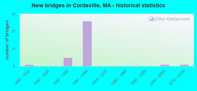
- New bridges - historical statistics
- 11930-1939
- 51950-1959
- 261960-1969
- 12000-2009
- 12010-2019

- Reconstructed bridges - Historical Statistics
- 11970-1979
- 21980-1989
- 01990-1999
- 12000-2009


- Bridge Condition - Deck
- 5.6%Excellent
- 5.6%Very good
- 22.2%Good
- 33.3%Satisfactory
- 33.3%Fair

- Bridge Condition - Superstructure
- 22.2%Very good
- 5.6%Good
- 22.2%Satisfactory
- 22.2%Fair
- 22.2%Poor
- 5.6%Serious

- Bridge Condition - Substructure
- 5.6%Excellent
- 5.6%Very good
- 27.8%Good
- 27.8%Satisfactory
- 22.2%Fair
- 11.1%Poor

- Bridge Condition - Channel
- 80.0%Good
- 20.0%Satisfactory

- Bridge Condition - Culverts
- 50.0%Good
- 50.0%Satisfactory
Find on map >> Show street view
Structure Number: H23003AXFMUNNBI, Location: .3 MI N OF ST-85 (Lat: 42.264725, Lng: -71.536306), Route carried "on" structure: City street , Year Built: 2002, Status: Open, Structure Length: 1.36m (4.46ft), Average Daily Traffic: 1,950 (year 2013), Truck Traffic: 1%, Average Future Daily Traffic: 3,080 (year 2032), Design Load: HS 20, Features Intersected: WATER SUDBURY RIVER, Facility Carried by Structure: HWY CEDAR ST EXT
Minimum Vertical Clearance: 30+ m (98+ ft), Kilometerpoint: 0.483, Lanes on structure: 2, Owner: Town or Township Highway Agency, Approaching Roadway Width: 6.1m (20.0ft), Material/Design: Steel, Design/Construction: Stringer/Multi-beam, Number Of Spans In Main Unit: 1, Length of Maximum Span: 11.4m (37.4ft), Curb-To-Curb Width: 6.1m (20.0ft), Out-to-Out Width: 6.9m (22.6ft)
Condition: Deck: Very good, Superstructure: Very good, Substructure: Good, Channel: Good, Inventory Rating: 75.0 metric tons, Method Used To Determine Inventory Rating: Load Factor (LF), Structural Evaluation: Better than present minimum criteria, Deck Geometry: High priority of replacement, Waterway Adequacy: Equal to present desirable criteria, Approach Roadway Alignment: Equal to present desirable criteria, Length Of Structure Improvement: 1.40m (4.59ft), Designated Inspection Frequency: Every 24 months, Inspection Date: January 2021, Bridge Improvement Cost: $964,000, Roadway Improvement Cost: $97,000, Total Project Cost: $1,447,000 ( Estimate for 2022), Deck Structure Type: Concrete Precast Panels, Wearing Surface/Protective System: Wearing Surface: Bituminous, Membrane: Built-up, Deck Protection: Epoxy Coated Reinforcing
Find on map >> Show street view
Structure Number: H23004B5GMUNNBI, Location: 1000FT S.OF SOUTHVILLE RD (Lat: 42.266339, Lng: -71.522439), Route carried "on" structure: State highway 85, Year Built: 2014, Status: Open, Structure Length: 1.82m (5.97ft), Average Daily Traffic: 12,300 (year 2018), Design Load: HL 93, Features Intersected: WATER SUDBURY RIVER
Minimum Vertical Clearance: 0.00m, Kilometerpoint: 13.985, Lanes on structure: 2, Owner: State Highway Agency, Approaching Roadway Width: 10.9m (35.8ft), Skew: 2 degrees, Material/Design: Steel, Design/Construction: Stringer/Multi-beam, Number Of Spans In Main Unit: 1, Length of Maximum Span: 13.7m (44.9ft), Curb or Sidewalk Widths: Left: 1.7m (5.6ft), Right: 0.0m, Curb-To-Curb Width: 11.0m (36.1ft), Out-to-Out Width: 13.7m (44.9ft)
Condition: Deck: Good, Superstructure: Very good, Substructure: Very good, Channel: Good, Operating Rating: 51.8 metric tons, Method Used To Determine Operating Rating: Load and Resistance Factor Rating (LRFR) rating reported by rating factor(RF) method using HL-93 loadings, Inventory Rating: 38.9 metric tons, Method Used To Determine Inventory Rating: Load and Resistance Factor Rating (LRFR) rating reported by rating factor(RF) method using HL-93 loadings, Structural Evaluation: Equal to present desirable criteria, Deck Geometry: Meets minimum limits, Waterway Adequacy: Superior to present desirable criteria, Approach Roadway Alignment: Equal to present desirable criteria, Designated Inspection Frequency: Every 24 months, Inspection Date: September 2020, Deck Structure Type: Concrete Precast Panels, Wearing Surface/Protective System: Wearing Surface: Bituminous, Membrane: Preformed Fabric, Deck Protection: Epoxy Coated Reinforcing
Find on map >> Show street view
Structure Number: H2300622WDOT634, Location: .7 MI EAST OF I - 495 (Lat: 42.267667, Lng: -71.552664), Route carried "on" structure: City street , Year Built: 1936, Year Reconstructed: 1976, Status: Posted for load, Structure Length: 5.67m (18.60ft), Average Daily Traffic: 4,238 (year 2019), Truck Traffic: 2%, Average Future Daily Traffic: 3,159 (year 2031), Design Load: H 20, Features Intersected: COMB MBTA/CSX & SUDBURY, Facility Carried by Structure: HWY FRUIT ST
Minimum Vertical Clearance: 30+ m (98+ ft), Kilometerpoint: 4.025, Lanes on structure: 2, Owner: State Highway Agency, Approaching Roadway Width: 9.1m (29.9ft), Skew: 1 degrees, Material/Design: Steel, Design/Construction: Stringer/Multi-beam, Number Of Spans In Main Unit: 1, Number Of Approach Spans: 3, Length of Maximum Span: 21.6m (70.9ft), Curb or Sidewalk Widths: Left: 1.5m (4.9ft), Right: 0.0m, Curb-To-Curb Width: 7.2m (23.6ft), Out-to-Out Width: 12.2m (40.0ft)
Condition: Deck: Satisfactory, Superstructure: Poor, Substructure: Poor, Channel: Good, Operating Rating: 42.7 metric tons, Method Used To Determine Operating Rating: Allowable Stress (AS), Inventory Rating: 28.8 metric tons, Method Used To Determine Inventory Rating: Allowable Stress (AS), Structural Evaluation: Meets minimum limits, Deck Geometry: High priority of replacement, Underclear: Meets minimum limits, Waterway Adequacy: Better than present minimum criteria, Approach Roadway Alignment: Equal to present desirable criteria, Length Of Structure Improvement: 6.80m (22.31ft), Designated Inspection Frequency: Every 12 months, Other Special Inspection Frequency: Every 12 months, Inspection Date: August 2021, Other Special Inspection Date: August 2021, Bridge Improvement Cost: $6,554,000, Roadway Improvement Cost: $656,000, Total Project Cost: $9,832,000 ( Estimate for 2022), Deck Structure Type: Concrete Cast-file-Place, Wearing Surface/Protective System: Wearing Surface: Bituminous, Membrane: Built-up
Find on map >> Show street view
Structure Number: H230081UPDOTNBI, Location: 2.2 MI N OF ST-135 (Lat: 42.266661, Lng: -71.564553), Route carried "on" structure: Interstate 495, Year Built: 1965, Status: Open, Structure Length: 6.55m (21.49ft), Average Daily Traffic: 48,553 (year 2019), Truck Traffic: 7%, Average Future Daily Traffic: 126,344 (year 2031), Design Load: H 20, Features Intersected: I 90
Minimum Vertical Clearance: 30+ m (98+ ft), Kilometerpoint: 93.404, Lanes on structure: 3, Lanes under structure: 7, Base Highway Network: Yes, Owner: State Highway Agency, Approaching Roadway Width: 15.8m (51.8ft), Skew: 2 degrees, Material/Design: Steel, Design/Construction: Stringer/Multi-beam, Number Of Spans In Main Unit: 4, Length of Maximum Span: 21.0m (68.9ft), Curb or Sidewalk Widths: Left: 0.2m (0.7ft), Right: 0.2m (0.7ft), Curb-To-Curb Width: 15.8m (51.8ft), Out-to-Out Width: 17.7m (58.1ft)
Condition: Deck: Fair, Superstructure: Poor, Substructure: Fair, Operating Rating: 54.3 metric tons, Method Used To Determine Operating Rating: Load Factor (LF), Inventory Rating: 32.5 metric tons, Method Used To Determine Inventory Rating: Load Factor (LF), Structural Evaluation: Meets minimum limits, Deck Geometry: Somewhat better than minimum adequacy, Underclear: High priority of corrective action, Approach Roadway Alignment: Equal to present desirable criteria, Length Of Structure Improvement: 6.60m (21.65ft), Designated Inspection Frequency: Every 9 months, Other Special Inspection Frequency: Every 9 months, Inspection Date: July 2021, Other Special Inspection Date: October 2021, Bridge Improvement Cost: $4,589,000, Roadway Improvement Cost: $459,000, Total Project Cost: $6,884,000 ( Estimate for 2022), Deck Structure Type: Concrete Cast-file-Place, Wearing Surface/Protective System: Wearing Surface: Bituminous, Membrane: Built-up
Find on map >> Show street view
Structure Number: H230081UVDOTNBI, Location: MM 106.4 (Lat: 42.266903, Lng: -71.564106), Route carried "on" structure: Interstate 495, Year Built: 1965, Status: Open, Structure Length: 6.55m (21.49ft), Average Daily Traffic: 39,688 (year 2020), Truck Traffic: 8%, Average Future Daily Traffic: 126,344 (year 2031), Design Load: H 20, Features Intersected: I 90
Minimum Vertical Clearance: 30+ m (98+ ft), Kilometerpoint: 93.404, Lanes on structure: 3, Lanes under structure: 7, Base Highway Network: Yes, Owner: State Highway Agency, Approaching Roadway Width: 15.8m (51.8ft), Skew: 2 degrees, Material/Design: Steel, Design/Construction: Stringer/Multi-beam, Number Of Spans In Main Unit: 4, Length of Maximum Span: 21.0m (68.9ft), Curb or Sidewalk Widths: Left: 0.2m (0.7ft), Right: 0.2m (0.7ft), Curb-To-Curb Width: 15.8m (51.8ft), Out-to-Out Width: 17.7m (58.1ft)
Condition: Deck: Fair, Superstructure: Poor, Substructure: Fair, Operating Rating: 52.2 metric tons, Method Used To Determine Operating Rating: Load Factor (LF), Inventory Rating: 31.3 metric tons, Method Used To Determine Inventory Rating: Load Factor (LF), Structural Evaluation: Meets minimum limits, Deck Geometry: Somewhat better than minimum adequacy, Underclear: High priority of replacement, Approach Roadway Alignment: Equal to present desirable criteria, Length Of Structure Improvement: 7.60m (24.93ft), Designated Inspection Frequency: Every 6 months, Other Special Inspection Frequency: Every 6 months, Inspection Date: July 2020, Other Special Inspection Date: January 2022, Bridge Improvement Cost: $8,082,000, Roadway Improvement Cost: $809,000, Total Project Cost: $12,124,000 ( Estimate for 2022), Deck Structure Type: Concrete Cast-file-Place, Wearing Surface/Protective System: Wearing Surface: Bituminous, Membrane: Built-up
Find on map >> Show street view
Structure Number: H2300921BDOTNBI, Location: .2 MI. S.OF I-90 (Lat: 42.261131, Lng: -71.562811), Route carried "on" structure: City street , Year Built: 1966, Status: Posted for load, Structure Length: 8.38m (27.49ft), Average Daily Traffic: 4,238 (year 2019), Truck Traffic: 6%, Average Future Daily Traffic: 5,133 (year 2031), Design Load: H 20, Features Intersected: I 495, Facility Carried by Structure: HWY FRUIT ST
Minimum Vertical Clearance: 30+ m (98+ ft), Kilometerpoint: 0.000, Lanes on structure: 2, Lanes under structure: 6, Owner: State Highway Agency, Approaching Roadway Width: 8.5m (27.9ft), Skew: 2 degrees, Material/Design: Steel, Design/Construction: Stringer/Multi-beam, Number Of Spans In Main Unit: 3, Length of Maximum Span: 29.3m (96.1ft), Curb or Sidewalk Widths: Left: 0.9m (3.0ft), Right: 0.9m (3.0ft), Curb-To-Curb Width: 8.5m (27.9ft), Out-to-Out Width: 10.4m (34.1ft)
Condition: Deck: Satisfactory, Superstructure: Fair, Substructure: Satisfactory, Operating Rating: 44.3 metric tons, Method Used To Determine Operating Rating: Allowable Stress (AS), Inventory Rating: 19.0 metric tons, Method Used To Determine Inventory Rating: Allowable Stress (AS), Structural Evaluation: Somewhat better than minimum adequacy, Deck Geometry: Meets minimum limits, Underclear: High priority of corrective action, Approach Roadway Alignment: Equal to present desirable criteria, Length Of Structure Improvement: 8.40m (27.56ft), Designated Inspection Frequency: Every 24 months, Inspection Date: September 2020, Bridge Improvement Cost: $3,432,000, Roadway Improvement Cost: $344,000, Total Project Cost: $5,149,000 ( Estimate for 2022), Deck Structure Type: Concrete Cast-file-Place, Wearing Surface/Protective System: Wearing Surface: Bituminous, Membrane: Built-up
Find on map >> Show street view
Structure Number: H2301220QDOTNBI, Location: 1.5 MI. S. OF RTE. 9 (Lat: 42.262819, Lng: -71.563206), Route carried "on" structure: Ramp Interstate 90, Year Built: 1968, Year Reconstructed: 2013, Status: Open, Structure Length: 7.56m (24.80ft), Average Daily Traffic: 25,581 (year 2020), Truck Traffic: 15%, Average Future Daily Traffic: 55,276 (year 2031), Design Load: HS 25 or greater, Features Intersected: I 495
Minimum Vertical Clearance: 30+ m (98+ ft), Kilometerpoint: 171.374, Lanes on structure: 3, Lanes under structure: 7, Base Highway Network: Yes, Owner: State Highway Agency, Approaching Roadway Width: 14.0m (45.9ft), Skew: 31 degrees, Material/Design: Steel, Design/Construction: Stringer/Multi-beam, Number Of Spans In Main Unit: 2, Length of Maximum Span: 27.7m (90.9ft), Curb-To-Curb Width: 16.5m (54.1ft), Out-to-Out Width: 18.2m (59.7ft)
Condition: Deck: Good, Superstructure: Good, Substructure: Satisfactory, Operating Rating: 60.8 metric tons, Method Used To Determine Operating Rating: Load Factor (LF), Inventory Rating: 36.4 metric tons, Method Used To Determine Inventory Rating: Load Factor (LF), Structural Evaluation: Equal to present minimum criteria, Deck Geometry: Superior to present desirable criteria, Underclear: High priority of corrective action, Approach Roadway Alignment: Equal to present desirable criteria, Length Of Structure Improvement: 7.60m (24.93ft), Designated Inspection Frequency: Every 24 months, Inspection Date: January 2022, Bridge Improvement Cost: $1,391,000, Roadway Improvement Cost: $140,000, Total Project Cost: $2,087,000 ( Estimate for 2022), Deck Structure Type: Concrete Cast-file-Place, Wearing Surface/Protective System: Wearing Surface: Bituminous, Membrane: Built-up, Deck Protection: Epoxy Coated Reinforcing
Find on map >> Show street view
Structure Number: H230134NVDOTNBI, Location: .2MI.W. I495 (Lat: 42.264531, Lng: -71.569522), Route carried "on" structure: Interstate 90, Year Built: 1968, Status: Open, Structure Length: 8.39m (27.53ft), Average Daily Traffic: 36,400 (year 2018), Truck Traffic: 12%, Average Future Daily Traffic: 15,793 (year 2033), Design Load: HS 20+Mod, Features Intersected: I 90
Minimum Vertical Clearance: 30+ m (98+ ft), Kilometerpoint: 171.069, Lanes on structure: 4, Lanes under structure: 8, Base Highway Network: Yes, Toll: On toll road, Owner: State Highway Agency, Approaching Roadway Width: 14.0m (45.9ft), Skew: 30 degrees, Material/Design: Steel, Design/Construction: Stringer/Multi-beam, Number Of Spans In Main Unit: 2, Length of Maximum Span: 27.4m (89.9ft), Curb or Sidewalk Widths: Left: 0.8m (2.6ft), Right: 0.0m, Curb-To-Curb Width: 14.0m (45.9ft), Out-to-Out Width: 15.9m (52.2ft)
Condition: Deck: Good, Superstructure: Satisfactory, Substructure: Fair, Operating Rating: 62.2 metric tons, Method Used To Determine Operating Rating: Load Factor (LF), Inventory Rating: 37.2 metric tons, Method Used To Determine Inventory Rating: Load Factor (LF), Structural Evaluation: Somewhat better than minimum adequacy, Deck Geometry: High priority of replacement, Underclear: High priority of corrective action, Approach Roadway Alignment: Equal to present desirable criteria, Length Of Structure Improvement: 8.40m (27.56ft), Designated Inspection Frequency: Every 24 months, Inspection Date: Febuary 2022, Bridge Improvement Cost: $5,247,000, Roadway Improvement Cost: $525,000, Total Project Cost: $7,871,000 ( Estimate for 2022), Deck Structure Type: Concrete Cast-file-Place, Wearing Surface/Protective System: Wearing Surface: Bituminous, Membrane: Built-up
Find on map >> Show street view
Structure Number: H230144NUDOTNBI, Location: .1 MI EAST OF I-495 (Lat: 42.267378, Lng: -71.562903), Route carried "on" structure: Interstate 90, Year Built: 1957, Status: Open, Structure Length: 0.91m (2.99ft), Average Daily Traffic: 102,416 (year 2019), Truck Traffic: 8%, Average Future Daily Traffic: 148,748 (year 2031), Design Load: HS 20, Features Intersected: WATER SUDBURY RIVER
Minimum Vertical Clearance: 0.00m, Kilometerpoint: 171.551, Lanes on structure: 7, Base Highway Network: Yes, Toll: On toll road, Owner: State Highway Agency, Approaching Roadway Width: 15.8m (51.8ft), Skew: 30 degrees, Material/Design: Concrete, Design/Construction: Culvert, Number Of Spans In Main Unit: 1, Length of Maximum Span: 9.1m (29.9ft)
Condition: Channel: Good, Culverts: Satisfactory, Structural Evaluation: Equal to present minimum criteria, Waterway Adequacy: Equal to present desirable criteria, Approach Roadway Alignment: Equal to present desirable criteria, Length Of Structure Improvement: 1.80m (5.91ft), Designated Inspection Frequency: Every 24 months, Underwater Inspection Frequency: Every 27 months, Inspection Date: September 2020, Underwater Inspection Date: July 2020, Bridge Improvement Cost: $1,545,000, Roadway Improvement Cost: $155,000, Total Project Cost: $2,318,000 ( Estimate for 2022)
Find on map >> Show street view
Structure Number: W240201U6DOTNBI, Location: 1.5 MI. N. OF I-90 (Lat: 42.288744, Lng: -71.567597), Route carried "on" structure: Interstate 495, Year Built: 1964, Status: Open, Structure Length: 5.67m (18.60ft), Average Daily Traffic: 52,351 (year 2019), Truck Traffic: 15%, Average Future Daily Traffic: 67,910 (year 2031), Design Load: HS 20, Features Intersected: ST 9 TURNPIKE RD
Minimum Vertical Clearance: 30+ m (98+ ft), Kilometerpoint: 95.850, Lanes on structure: 4, Lanes under structure: 6, Base Highway Network: Yes, Owner: State Highway Agency, Approaching Roadway Width: 15.8m (51.8ft), Material/Design: Steel, Design/Construction: Stringer/Multi-beam, Number Of Spans In Main Unit: 2, Number Of Approach Spans: 2, Length of Maximum Span: 18.8m (61.7ft), Curb or Sidewalk Widths: Left: 0.3m (1.0ft), Right: 0.3m (1.0ft), Curb-To-Curb Width: 15.8m (51.8ft), Out-to-Out Width: 17.7m (58.1ft)
Condition: Deck: Fair, Superstructure: Fair, Substructure: Good, Operating Rating: 61.6 metric tons, Method Used To Determine Operating Rating: Load Factor (LF), Inventory Rating: 36.9 metric tons, Method Used To Determine Inventory Rating: Load Factor (LF), Structural Evaluation: Somewhat better than minimum adequacy, Deck Geometry: High priority of replacement, Underclear: High priority of corrective action, Approach Roadway Alignment: Equal to present desirable criteria, Length Of Structure Improvement: 5.70m (18.70ft), Designated Inspection Frequency: Every 24 months, Inspection Date: August 2020, Bridge Improvement Cost: $3,970,000, Roadway Improvement Cost: $398,000, Total Project Cost: $5,956,000 ( Estimate for 2022), Deck Structure Type: Concrete Cast-file-Place, Wearing Surface/Protective System: Wearing Surface: Bituminous, Membrane: Built-up
Find on map >> Show street view
Structure Number: W240211U5DOTNBI, Location: 1 MI.NTH.OF I-90 (Lat: 42.288769, Lng: -71.566264), Route carried "on" structure: Interstate 495, Year Built: 1962, Status: Open, Structure Length: 5.79m (19.00ft), Average Daily Traffic: 49,074 (year 2018), Truck Traffic: 20%, Average Future Daily Traffic: 67,910 (year 2031), Design Load: H 20, Features Intersected: ST 9 TURNPIKE RD
Minimum Vertical Clearance: 6.10m (20.01ft), Kilometerpoint: 95.850, Lanes on structure: 4, Lanes under structure: 6, Base Highway Network: Yes, Owner: State Highway Agency, Approaching Roadway Width: 15.2m (49.9ft), Skew: 1 degrees, Material/Design: Steel, Design/Construction: Stringer/Multi-beam, Number Of Spans In Main Unit: 4, Length of Maximum Span: 19.2m (63.0ft), Curb-To-Curb Width: 15.2m (49.9ft), Out-to-Out Width: 17.1m (56.1ft)
Condition: Deck: Fair, Superstructure: Fair, Substructure: Satisfactory, Operating Rating: 52.2 metric tons, Method Used To Determine Operating Rating: Load Factor (LF), Inventory Rating: 31.3 metric tons, Method Used To Determine Inventory Rating: Load Factor (LF), Structural Evaluation: Somewhat better than minimum adequacy, Deck Geometry: High priority of replacement, Underclear: High priority of corrective action, Approach Roadway Alignment: Equal to present desirable criteria, Length Of Structure Improvement: 5.80m (19.03ft), Designated Inspection Frequency: Every 24 months, Inspection Date: August 2020, Bridge Improvement Cost: $3,896,000, Roadway Improvement Cost: $390,000, Total Project Cost: $5,845,000 ( Estimate for 2022), Deck Structure Type: Concrete Cast-file-Place, Wearing Surface/Protective System: Wearing Surface: Bituminous, Membrane: Built-up
Find on map >> Show street view
Structure Number: W240221U1DOTNBI, Location: 1.4 MI SO. OF ST 9 (Lat: 42.268881, Lng: -71.564450), Route carried "on" structure: Interstate 495, Year Built: 1968, Status: Open, Structure Length: 4.33m (14.21ft), Average Daily Traffic: 39,688 (year 2020), Truck Traffic: 8%, Average Future Daily Traffic: 75,806 (year 2032), Design Load: H 20, Features Intersected: RR MBTA/CSX
Minimum Vertical Clearance: 30+ m (98+ ft), Kilometerpoint: 93.500, Lanes on structure: 4, Base Highway Network: Yes, Owner: State Highway Agency, Approaching Roadway Width: 15.2m (49.9ft), Skew: 1 degrees, Material/Design: Steel, Design/Construction: Stringer/Multi-beam, Number Of Spans In Main Unit: 3, Length of Maximum Span: 19.5m (64.0ft), Curb-To-Curb Width: 15.2m (49.9ft), Out-to-Out Width: 17.1m (56.1ft)
Condition: Deck: Satisfactory, Superstructure: Poor, Substructure: Fair, Operating Rating: 52.0 metric tons, Method Used To Determine Operating Rating: Load Factor (LF), Inventory Rating: 32.5 metric tons, Method Used To Determine Inventory Rating: Load Factor (LF), Structural Evaluation: Meets minimum limits, Deck Geometry: High priority of replacement, Underclear: Somewhat better than minimum adequacy, Approach Roadway Alignment: Equal to present desirable criteria, Length Of Structure Improvement: 4.40m (14.44ft), Designated Inspection Frequency: Every 6 months, Other Special Inspection Frequency: Every 6 months, Inspection Date: December 2021, Other Special Inspection Date: December 2021, Bridge Improvement Cost: $2,956,000, Roadway Improvement Cost: $296,000, Total Project Cost: $4,435,000 ( Estimate for 2022), Deck Structure Type: Concrete Cast-file-Place, Wearing Surface/Protective System: Wearing Surface: Bituminous, Membrane: Built-up
Find on map >> Show street view
Structure Number: W240221U2DOTNBI, Location: 600 FT N OF HOPKINTON TL (Lat: 42.268878, Lng: -71.564939), Route carried "on" structure: Interstate 495, Year Built: 1968, Status: Temporarily open, Structure Length: 4.33m (14.21ft), Average Daily Traffic: 34,892 (year 2020), Truck Traffic: 8%, Average Future Daily Traffic: 75,806 (year 2032), Design Load: H 20, Features Intersected: RR MBTA/CSX
Minimum Vertical Clearance: 30+ m (98+ ft), Kilometerpoint: 93.500, Lanes on structure: 3, Base Highway Network: Yes, Owner: State Highway Agency, Approaching Roadway Width: 15.2m (49.9ft), Skew: 1 degrees, Material/Design: Steel, Design/Construction: Stringer/Multi-beam, Number Of Spans In Main Unit: 3, Length of Maximum Span: 19.5m (64.0ft), Curb-To-Curb Width: 15.2m (49.9ft), Out-to-Out Width: 17.1m (56.1ft)
Condition: Deck: Satisfactory, Superstructure: Serious, Substructure: Poor, Operating Rating: 53.9 metric tons, Method Used To Determine Operating Rating: Allowable Stress (AS), Inventory Rating: 30.4 metric tons, Method Used To Determine Inventory Rating: Allowable Stress (AS), Structural Evaluation: High priority of corrective action, Deck Geometry: Meets minimum limits, Underclear: Somewhat better than minimum adequacy, Approach Roadway Alignment: Equal to present desirable criteria, Length Of Structure Improvement: 5.40m (17.72ft), Designated Inspection Frequency: Every 6 months, Other Special Inspection Frequency: Every 6 months, Inspection Date: December 2021, Other Special Inspection Date: December 2021, Bridge Improvement Cost: $5,742,000, Roadway Improvement Cost: $575,000, Total Project Cost: $8,614,000 ( Estimate for 2022), Deck Structure Type: Concrete Cast-file-Place, Wearing Surface/Protective System: Wearing Surface: Bituminous, Membrane: Built-up
Find on map >> Show street view
Structure Number: W240231U3DOTNBI, Location: 1.7 MI SE OF ST-9 (Lat: 42.276083, Lng: -71.565572), Route carried "on" structure: Interstate 495, Year Built: 1966, Status: Open, Structure Length: 2.16m (7.09ft), Average Daily Traffic: 51,610 (year 2019), Truck Traffic: 7%, Average Future Daily Traffic: 78,965 (year 2032), Design Load: HS 20, Features Intersected: HWY FLANDERS RD
Minimum Vertical Clearance: 30+ m (98+ ft), Kilometerpoint: 94.385, Lanes on structure: 3, Lanes under structure: 2, Base Highway Network: Yes, Owner: State Highway Agency, Approaching Roadway Width: 15.0m (49.2ft), Material/Design: Prestressed concrete, Design/Construction: Stringer/Multi-beam, Number Of Spans In Main Unit: 1, Length of Maximum Span: 20.0m (65.6ft), Curb or Sidewalk Widths: Left: 0.4m (1.3ft), Right: 0.2m (0.7ft), Curb-To-Curb Width: 15.0m (49.2ft), Out-to-Out Width: 16.6m (54.5ft)
Condition: Deck: Satisfactory, Superstructure: Satisfactory, Substructure: Satisfactory, Operating Rating: 55.5 metric tons, Method Used To Determine Operating Rating: Allowable Stress (AS), Inventory Rating: 38.7 metric tons, Method Used To Determine Inventory Rating: Allowable Stress (AS), Structural Evaluation: Equal to present minimum criteria, Deck Geometry: Meets minimum limits, Underclear: Somewhat better than minimum adequacy, Approach Roadway Alignment: Equal to present desirable criteria, Length Of Structure Improvement: 2.20m (7.22ft), Designated Inspection Frequency: Every 24 months, Inspection Date: November 2021, Bridge Improvement Cost: $706,000, Roadway Improvement Cost: $71,000, Total Project Cost: $1,060,000 ( Estimate for 2022), Deck Structure Type: Concrete Cast-file-Place, Wearing Surface/Protective System: Wearing Surface: Bituminous, Membrane: Built-up
Find on map >> Show street view
Structure Number: W240231U4DOTNBI, Location: 1.7 MI SE OF ST-9 (Lat: 42.276008, Lng: -71.566244), Route carried "on" structure: Interstate 495, Year Built: 1966, Status: Open, Structure Length: 2.13m (6.99ft), Average Daily Traffic: 59,658 (year 2018), Truck Traffic: 7%, Average Future Daily Traffic: 78,965 (year 2032), Design Load: HS 20, Features Intersected: HWY FLANDERS RD
Minimum Vertical Clearance: 30+ m (98+ ft), Kilometerpoint: 94.385, Lanes on structure: 3, Lanes under structure: 2, Base Highway Network: Yes, Owner: State Highway Agency, Approaching Roadway Width: 15.2m (49.9ft), Material/Design: Prestressed concrete, Design/Construction: Stringer/Multi-beam, Number Of Spans In Main Unit: 1, Length of Maximum Span: 20.4m (66.9ft), Curb-To-Curb Width: 15.2m (49.9ft), Out-to-Out Width: 17.1m (56.1ft)
Condition: Deck: Satisfactory, Superstructure: Satisfactory, Substructure: Good, Operating Rating: 56.1 metric tons, Method Used To Determine Operating Rating: Allowable Stress (AS), Inventory Rating: 39.1 metric tons, Method Used To Determine Inventory Rating: Allowable Stress (AS), Structural Evaluation: Equal to present minimum criteria, Deck Geometry: Meets minimum limits, Underclear: Somewhat better than minimum adequacy, Approach Roadway Alignment: Equal to present desirable criteria, Length Of Structure Improvement: 2.20m (7.22ft), Designated Inspection Frequency: Every 24 months, Inspection Date: November 2021, Bridge Improvement Cost: $664,000, Roadway Improvement Cost: $67,000, Total Project Cost: $997,000 ( Estimate for 2022), Deck Structure Type: Concrete Cast-file-Place, Wearing Surface/Protective System: Wearing Surface: Bituminous, Membrane: Built-up
Find on map >> Show street view
Structure Number: W240241U0DOTNBI, Location: 0.2 MI N OF I-90 (Lat: 42.267844, Lng: -71.564231), Route carried "on" structure: Interstate 495, Year Built: 1966, Status: Open, Structure Length: 1.04m (3.41ft), Average Daily Traffic: 69,784 (year 2020), Truck Traffic: 8%, Average Future Daily Traffic: 66,331 (year 2032), Design Load: HS 20+Mod, Features Intersected: WATER SUDBURY RIVER
Minimum Vertical Clearance: 30+ m (98+ ft), Kilometerpoint: 94.492, Lanes on structure: 7, Base Highway Network: Yes, Owner: State Highway Agency, Approaching Roadway Width: 59.1m (193.9ft), Skew: 20 degrees, Material/Design: Concrete, Design/Construction: Culvert, Number Of Spans In Main Unit: 2, Length of Maximum Span: 4.6m (15.1ft)
Condition: Channel: Satisfactory, Culverts: Good, Structural Evaluation: Better than present minimum criteria, Waterway Adequacy: Equal to present desirable criteria, Approach Roadway Alignment: Equal to present desirable criteria, Designated Inspection Frequency: Every 24 months, Underwater Inspection Frequency: Every 36 months, Inspection Date: October 2021, Underwater Inspection Date: October 2019
Find on map >> Show street view
Structure Number: W240274NFDOTNBI, Location: .3 MI E OF I-495 (Lat: 42.268653, Lng: -71.559758), Route carried "on" structure: Interstate 90, Year Built: 1957, Year Reconstructed: 1986, Status: Open, Structure Length: 7.13m (23.39ft), Average Daily Traffic: 35,483 (year 2020), Truck Traffic: 12%, Average Future Daily Traffic: 148,748 (year 2032), Design Load: HS 20, Features Intersected: RR MBTA/CSX
Minimum Vertical Clearance: 30+ m (98+ ft), Kilometerpoint: 171.873, Lanes on structure: 3, Base Highway Network: Yes, Toll: On toll road, Owner: State Highway Agency, Approaching Roadway Width: 16.7m (54.8ft), Skew: 5 degrees, Material/Design: Steel continuous, Design/Construction: Stringer/Multi-beam, Number Of Spans In Main Unit: 3, Length of Maximum Span: 26.2m (86.0ft), Curb-To-Curb Width: 16.7m (54.8ft), Out-to-Out Width: 17.6m (57.7ft)
Condition: Deck: Fair, Superstructure: Fair, Substructure: Good, Operating Rating: 62.6 metric tons, Method Used To Determine Operating Rating: Load Factor (LF), Inventory Rating: 37.5 metric tons, Method Used To Determine Inventory Rating: Load Factor (LF), Structural Evaluation: Somewhat better than minimum adequacy, Deck Geometry: Equal to present minimum criteria, Underclear: Equal to present minimum criteria, Approach Roadway Alignment: Equal to present desirable criteria, Length Of Structure Improvement: 7.20m (23.62ft), Designated Inspection Frequency: Every 24 months, Inspection Date: August 2021, Bridge Improvement Cost: $5,001,000, Roadway Improvement Cost: $501,000, Total Project Cost: $7,502,000 ( Estimate for 2022), Deck Structure Type: Concrete Cast-file-Place, Wearing Surface/Protective System: Wearing Surface: Bituminous, Membrane: Built-up, Deck Protection: Epoxy Coated Reinforcing
Find on map >> Show street view
Structure Number: W240274NGDOTNBI, Location: .3MI.EAST I495 L4 (Lat: 42.268661, Lng: -71.560181), Route carried "on" structure: Interstate 90, Year Built: 1957, Year Reconstructed: 1986, Status: Open, Structure Length: 7.09m (23.26ft), Average Daily Traffic: 50,219 (year 2018), Truck Traffic: 7%, Average Future Daily Traffic: 148,748 (year 2032), Design Load: HS 20, Features Intersected: RR MBTA/CSX
Minimum Vertical Clearance: 30+ m (98+ ft), Kilometerpoint: 171.873, Lanes on structure: 3, Base Highway Network: Yes, Toll: On toll road, Owner: State Highway Agency, Approaching Roadway Width: 16.0m (52.5ft), Skew: 5 degrees, Material/Design: Steel continuous, Design/Construction: Stringer/Multi-beam, Number Of Spans In Main Unit: 3, Length of Maximum Span: 26.2m (86.0ft), Curb-To-Curb Width: 16.0m (52.5ft), Out-to-Out Width: 17.2m (56.4ft)
Condition: Deck: Fair, Superstructure: Satisfactory, Substructure: Satisfactory, Operating Rating: 62.2 metric tons, Method Used To Determine Operating Rating: Load Factor (LF), Inventory Rating: 37.2 metric tons, Method Used To Determine Inventory Rating: Load Factor (LF), Structural Evaluation: Equal to present minimum criteria, Deck Geometry: Equal to present minimum criteria, Underclear: Equal to present minimum criteria, Approach Roadway Alignment: Equal to present desirable criteria, Length Of Structure Improvement: 7.10m (23.29ft), Designated Inspection Frequency: Every 24 months, Inspection Date: August 2021, Bridge Improvement Cost: $5,449,000, Roadway Improvement Cost: $545,000, Total Project Cost: $8,174,000 ( Estimate for 2022), Deck Structure Type: Concrete Cast-file-Place, Wearing Surface/Protective System: Wearing Surface: Bituminous, Membrane: Built-up, Deck Protection: Epoxy Coated Reinforcing
Find on map >> Show street view
Structure Number: W240324NDDOTNBI, Location: I-90 MM 107.2 (Lat: 42.271019, Lng: -71.552903), Route carried "on" structure: Interstate 90, Year Built: 1957, Year Reconstructed: 2021, Status: Open, Structure Length: 1.38m (4.53ft), Average Daily Traffic: 35,799 (year 2020), Truck Traffic: 10%, Average Future Daily Traffic: 108,000 (year 2032), Design Load: HL 93, Features Intersected: HWY FLANDERS RD
Minimum Vertical Clearance: 99.00m (324.80ft), Kilometerpoint: 172.517, Lanes on structure: 4, Lanes under structure: 2, Base Highway Network: Yes, Toll: On toll road, Owner: State Highway Agency, Approaching Roadway Width: 15.6m (51.2ft), Skew: 1 degrees, Material/Design: Prestressed concrete, Design/Construction: Tee Beam, Number Of Spans In Main Unit: 1, Length of Maximum Span: 13.4m (44.0ft), Curb-To-Curb Width: 15.6m (51.2ft), Out-to-Out Width: 16.9m (55.4ft)
Condition: Deck: Good, Superstructure: Very good, Substructure: Good, Operating Rating: 54.7 metric tons, Method Used To Determine Operating Rating: Load Factor (LF), Inventory Rating: 32.8 metric tons, Method Used To Determine Inventory Rating: Load Factor (LF), Structural Evaluation: Better than present minimum criteria, Deck Geometry: High priority of replacement, Underclear: High priority of corrective action, Approach Roadway Alignment: Better than present minimum criteria, Designated Inspection Frequency: Every 24 months, Inspection Date: November 2021, Deck Structure Type: Concrete Cast-file-Place, Wearing Surface/Protective System: Wearing Surface: Bituminous, Membrane: Built-up, Deck Protection: Epoxy Coated Reinforcing
Find on map >> Show street view
Structure Number: W240324NEDOTNBI, Location: I-90 MM 107.2 (Lat: 42.271175, Lng: -71.553047), Route carried "on" structure: Interstate 90, Year Built: 1957, Year Reconstructed: 2021, Status: Open, Structure Length: 1.48m (4.86ft), Average Daily Traffic: 34,828 (year 2020), Truck Traffic: 10%, Average Future Daily Traffic: 74,374 (year 2032), Design Load: HL 93, Features Intersected: HWY FLANDERS RD
Minimum Vertical Clearance: 30+ m (98+ ft), Kilometerpoint: 172.517, Lanes on structure: 3, Lanes under structure: 2, Base Highway Network: Yes, Toll: On toll road, Owner: State Highway Agency, Approaching Roadway Width: 16.2m (53.1ft), Skew: 2 degrees, Material/Design: Prestressed concrete, Design/Construction: Tee Beam, Number Of Spans In Main Unit: 1, Length of Maximum Span: 13.5m (44.3ft), Curb-To-Curb Width: 16.2m (53.1ft), Out-to-Out Width: 17.2m (56.4ft)
Condition: Deck: Excellent, Superstructure: Very good, Substructure: Excellent, Operating Rating: 54.7 metric tons, Method Used To Determine Operating Rating: Load Factor (LF), Inventory Rating: 32.8 metric tons, Method Used To Determine Inventory Rating: Load Factor (LF), Structural Evaluation: Equal to present desirable criteria, Deck Geometry: Equal to present minimum criteria, Underclear: Meets minimum limits, Approach Roadway Alignment: Equal to present desirable criteria, Designated Inspection Frequency: Every 24 months, Inspection Date: December 2021, Deck Structure Type: Concrete Cast-file-Place, Wearing Surface/Protective System: Wearing Surface: Bituminous, Membrane: Built-up, Deck Protection: Epoxy Coated Reinforcing
Find on map >> Show street view
Structure Number: H230081UPDOTNBI, Location: I-495 SB/ I-90 (Lat: 42.266667, Lng: -71.566667), Route carried "under" structure: Interstate 90, Year Built: 1965, Structure Length: 0. m, Average Daily Traffic: 15,000 (year 0000), Features Intersected: I 90 EB, Facility Carried by Structure: I 495 SB
Minimum Vertical Clearance: 4.47m (14.67ft), Kilometerpoint: 171.390, Lanes on structure: 3, Lanes under structure: 3, Toll: On toll road, Material/Design: Steel, Design/Construction: Stringer/Multi-beam, Length of Maximum Span: 21.6m (70.9ft)
Find on map >> Show street view
Structure Number: H230081UPDOTNBI, Location: I-495 SB/ I-90 (Lat: 42.266667, Lng: -71.566667), Route carried "under" structure: Interstate 90, Year Built: 1965, Structure Length: 0. m, Average Daily Traffic: 15,000 (year 0000), Features Intersected: I 90 WB, Facility Carried by Structure: I 495 SB
Minimum Vertical Clearance: 4.47m (14.67ft), Kilometerpoint: 171.294, Lanes on structure: 3, Lanes under structure: 3, Toll: On toll road, Material/Design: Steel, Design/Construction: Stringer/Multi-beam, Length of Maximum Span: 21.6m (70.9ft)
Find on map >> Show street view
Structure Number: H230081UVDOTNBI, Location: I-495 NB/ I-90 (Lat: 42.266667, Lng: -71.550000), Route carried "under" structure: Interstate 90, Year Built: 1965, Structure Length: 0. m, Average Daily Traffic: 15,000 (year 0000), Features Intersected: I 90 EB, Facility Carried by Structure: I 495 NB
Minimum Vertical Clearance: 4.47m (14.67ft), Kilometerpoint: 171.407, Lanes on structure: 3, Lanes under structure: 3, Toll: On toll road, Material/Design: Steel, Design/Construction: Stringer/Multi-beam, Length of Maximum Span: 21.6m (70.9ft)
Find on map >> Show street view
Structure Number: H230081UVDOTNBI, Location: I-495 NB/ I-90 (Lat: 42.266667, Lng: -71.550000), Route carried "under" structure: Interstate 90, Year Built: 1965, Structure Length: 0. m, Average Daily Traffic: 15,000 (year 0000), Features Intersected: I 90 WB, Facility Carried by Structure: I 495 NB
Minimum Vertical Clearance: 4.47m (14.67ft), Kilometerpoint: 171.310, Lanes on structure: 3, Lanes under structure: 3, Toll: On toll road, Material/Design: Steel, Design/Construction: Stringer/Multi-beam, Length of Maximum Span: 21.6m (70.9ft)
Find on map >> Show street view
Structure Number: H2300921BDOTNBI, Location: FRUIT ST/ I-495 (Lat: 42.266667, Lng: -71.566667), Route carried "under" structure: Interstate 495, Year Built: 1968, Structure Length: 0. m, Average Daily Traffic: 15,000 (year 0000), Features Intersected: I 495 SB, Facility Carried by Structure: HWY FRUIT ST
Minimum Vertical Clearance: 5.05m (16.57ft), Kilometerpoint: 0.000, Lanes on structure: 3, Lanes under structure: 2, Material/Design: Steel, Design/Construction: Stringer/Multi-beam, Length of Maximum Span: 30.5m (100.1ft)
Find on map >> Show street view
Structure Number: H2300921BDOTNBI, Location: FRUIT ST/ I-495 (Lat: 42.266667, Lng: -71.566667), Route carried "under" structure: Interstate 495, Year Built: 1968, Structure Length: 0. m, Average Daily Traffic: 15,000 (year 0000), Features Intersected: I 495 NB, Facility Carried by Structure: HWY FRUIT ST
Minimum Vertical Clearance: 5.05m (16.57ft), Kilometerpoint: 0.000, Lanes on structure: 3, Lanes under structure: 2, Material/Design: Steel, Design/Construction: Stringer/Multi-beam, Length of Maximum Span: 30.5m (100.1ft)
Find on map >> Show street view
Structure Number: H2301220QDOTNBI, Location: I-90 RAMP ON CL/ I-495 (Lat: 42.266667, Lng: -71.566667), Route carried "under" structure: Interstate 495, Year Built: 1968, Structure Length: 0. m, Average Daily Traffic: 15,000 (year 0000), Features Intersected: I 495 SB, Facility Carried by Structure: I 90 RAMPS
Minimum Vertical Clearance: 5.05m (16.57ft), Kilometerpoint: 0.000, Lanes on structure: 3, Lanes under structure: 2, Material/Design: Steel, Design/Construction: Stringer/Multi-beam, Length of Maximum Span: 28.0m (91.9ft)
Find on map >> Show street view
Structure Number: H2301220QDOTNBI, Location: I-90 RAMP ON CL/ I-495 (Lat: 42.266667, Lng: -71.566667), Route carried "under" structure: Interstate 495, Year Built: 1968, Structure Length: 0. m, Average Daily Traffic: 15,000 (year 0000), Features Intersected: I 495 NB, Facility Carried by Structure: I 90 RAMPS
Minimum Vertical Clearance: 5.05m (16.57ft), Kilometerpoint: 0.000, Lanes on structure: 3, Lanes under structure: 2, Material/Design: Steel, Design/Construction: Stringer/Multi-beam, Length of Maximum Span: 28.0m (91.9ft)
Find on map >> Show street view
Structure Number: H230134NVDOTNBI, Location: .2MI.W.RTE495 (Lat: 42.266667, Lng: -71.566667), Route carried "under" structure: Interstate 90, Year Built: 1967, Structure Length: 0. m, Average Daily Traffic: 16,576 (year 0000), Features Intersected: I 90 EB
Minimum Vertical Clearance: 4.27m (14.01ft), Kilometerpoint: 171.069, Lanes on structure: 2, Lanes under structure: 3, Toll: On toll road, Material/Design: Steel, Design/Construction: Stringer/Multi-beam, Length of Maximum Span: 27.4m (89.9ft)
Find on map >> Show street view
Structure Number: H230134NVDOTNBI, Location: .2MI.W.RTE495 (Lat: 42.266667, Lng: -71.566667), Route carried "under" structure: Interstate 90, Year Built: 1967, Structure Length: 0. m, Average Daily Traffic: 16,576 (year 0000), Features Intersected: I 90 WB
Minimum Vertical Clearance: 4.27m (14.01ft), Kilometerpoint: 171.069, Lanes on structure: 2, Lanes under structure: 3, Toll: On toll road, Material/Design: Steel, Design/Construction: Stringer/Multi-beam, Length of Maximum Span: 27.4m (89.9ft)
Find on map >> Show street view
Structure Number: W240201U6DOTNBI, Location: I 495 SB/ST 9 (Lat: 42.283333, Lng: -71.566667), Route carried "under" structure: State highway 9, Year Built: 1964, Structure Length: 0. m, Average Daily Traffic: 22,000 (year 0000), Features Intersected: ST 9 WB
Minimum Vertical Clearance: 4.50m (14.76ft), Kilometerpoint: 0.000, Lanes on structure: 3, Lanes under structure: 4, Material/Design: Steel, Design/Construction: Stringer/Multi-beam, Length of Maximum Span: 19.2m (63.0ft)
Find on map >> Show street view
Structure Number: W240201U6DOTNBI, Location: I 495 SB/ST 9 (Lat: 42.283333, Lng: -71.566667), Route carried "under" structure: State highway 9, Year Built: 1964, Structure Length: 0. m, Average Daily Traffic: 22,000 (year 0000), Features Intersected: ST 9 EB
Minimum Vertical Clearance: 4.50m (14.76ft), Kilometerpoint: 0.000, Lanes on structure: 3, Lanes under structure: 4, Material/Design: Steel, Design/Construction: Stringer/Multi-beam, Length of Maximum Span: 19.2m (63.0ft)
Find on map >> Show street view
Structure Number: W240211U5DOTNBI, Location: STATION 80+00 (Lat: 42.283333, Lng: -71.566667), Route carried "under" structure: State highway 9, Year Built: 1964, Structure Length: 0. m, Average Daily Traffic: 22,000 (year 0000), Features Intersected: ST 9 EB
Minimum Vertical Clearance: 4.65m (15.26ft), Kilometerpoint: 0.000, Lanes on structure: 3, Lanes under structure: 4, Material/Design: Steel, Design/Construction: Stringer/Multi-beam, Length of Maximum Span: 19.2m (63.0ft)
Find on map >> Show street view
Structure Number: W240211U5DOTNBI, Location: STATION 80+00 (Lat: 42.283333, Lng: -71.566667), Route carried "under" structure: State highway 9, Year Built: 1964, Structure Length: 0. m, Average Daily Traffic: 22,000 (year 0000), Features Intersected: ST 9 WB
Minimum Vertical Clearance: 4.65m (15.26ft), Kilometerpoint: 0.000, Lanes on structure: 3, Lanes under structure: 4, Material/Design: Steel, Design/Construction: Stringer/Multi-beam, Length of Maximum Span: 19.2m (63.0ft)