Bridge Statistics for Covington, Virginia (VA)
Condition, Traffic, Stress, Structural Evaluation, Project Costs
- National Bridge Inventory (NBI) Statistics
- 33Number of bridges
- 509ft / 155mTotal length
- $5,146,000Total costs
- 154,440Total average daily traffic
- 20,536Total average daily truck traffic
- National Bridge Inventory (NBI) Registered Bridges for Covington
- No street view available for this location
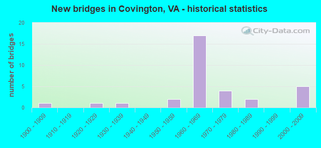
- New bridges - historical statistics
- 11900-1909
- 11920-1929
- 11930-1939
- 21950-1959
- 171960-1969
- 41970-1979
- 21980-1989
- 52000-2009

- Reconstructed bridges - Historical Statistics
- 11990-1999
- 12000-2009


- Bridge Condition - Deck
- 56.3%Good
- 31.3%Satisfactory
- 12.5%Fair

- Bridge Condition - Superstructure
- 6.3%Very good
- 50.0%Good
- 31.3%Satisfactory
- 12.5%Fair

- Bridge Condition - Substructure
- 50.0%Good
- 37.5%Satisfactory
- 12.5%Fair

- Bridge Condition - Channel
- 14.3%Very good
- 28.6%Good
- 28.6%Satisfactory
- 28.6%Fair

- Bridge Condition - Culverts
- 36.4%Good
- 45.5%Satisfactory
- 18.2%Fair
Find on map >> Show street view
Structure Number: 938, Location: 0.08 TO WRS - 0.07 RT 688 (Lat: 37.794739, Lng: -79.996375), Route carried "on" structure: US 60, Year Built: 1929, Status: Open, Structure Length: 12.01m (39.40ft), Average Daily Traffic: 3,242 (year 2020), Truck Traffic: 18%, Average Future Daily Traffic: 3,566 (year 2040), Design Load: HS 20+Mod, Features Intersected: JACKSON RIVER, Facility Carried by Structure: MIDLAND TRAIL
Minimum Vertical Clearance: 30+ m (98+ ft), Kilometerpoint: 23.952, Lanes on structure: 2, Owner: State Highway Agency, Approaching Roadway Width: 6.1m (20.0ft), Material/Design: Concrete, Design/Construction: Arch - Deck, Number Of Spans In Main Unit: 3, Length of Maximum Span: 41.1m (134.8ft), Curb or Sidewalk Widths: Left: 1.7m (5.6ft), Right: 1.7m (5.6ft), Curb-To-Curb Width: 7.0m (23.0ft), Out-to-Out Width: 7.6m (24.9ft)
Condition: Deck: Fair, Superstructure: Fair, Substructure: Satisfactory, Channel: Good, Operating Rating: 38.3 metric tons, Method Used To Determine Operating Rating: Load and Resistance Factor (LRFR), Inventory Rating: 29.5 metric tons, Method Used To Determine Inventory Rating: Load and Resistance Factor (LRFR), Structural Evaluation: Somewhat better than minimum adequacy, Deck Geometry: High priority of replacement, Waterway Adequacy: Better than present minimum criteria, Approach Roadway Alignment: Better than present minimum criteria, Length Of Structure Improvement: 13.53m (44.39ft), Designated Inspection Frequency: Every 12 months, Underwater Inspection Frequency: Every 60 months, Inspection Date: Febuary 2022, Underwater Inspection Date: June 2019, Bridge Improvement Cost: $1,690,000, Roadway Improvement Cost: $175,000, Total Project Cost: $2,000,000 ( Estimate for 2014), Deck Structure Type: Concrete Cast-file-Place, Wearing Surface/Protective System: Wearing Surface: Latex Concrete
Find on map >> Show street view
Structure Number: 94, Location: 0.52 TO ECL & 7.22 TO 60 (Lat: 37.774800, Lng: -79.967800), Route carried "on" structure: Interstate 64, Year Built: 1964, Status: Open, Structure Length: 5.30m (17.39ft), Average Daily Traffic: 5,785 (year 2020), Truck Traffic: 24%, Average Future Daily Traffic: 8,099 (year 2040), Design Load: HS 20+Mod, Features Intersected: CONN TO RTES 60 & 220
Minimum Vertical Clearance: 30+ m (98+ ft), Kilometerpoint: 26.629, Lanes on structure: 2, Lanes under structure: 4, Base Highway Network: Yes, Owner: State Highway Agency, Approaching Roadway Width: 11.3m (37.1ft), Material/Design: Steel, Design/Construction: Stringer/Multi-beam, Number Of Spans In Main Unit: 3, Length of Maximum Span: 24.1m (79.1ft), Curb-To-Curb Width: 12.8m (42.0ft), Out-to-Out Width: 13.4m (44.0ft)
Condition: Deck: Good, Superstructure: Good, Substructure: Satisfactory, Operating Rating: 60.8 metric tons, Method Used To Determine Operating Rating: Load and Resistance Factor (LRFR), Inventory Rating: 47.2 metric tons, Method Used To Determine Inventory Rating: Load and Resistance Factor (LRFR), Structural Evaluation: Equal to present minimum criteria, Deck Geometry: Equal to present desirable criteria, Underclear: High priority of corrective action, Approach Roadway Alignment: Equal to present desirable criteria, Designated Inspection Frequency: Every 24 months, Inspection Date: October 2020, Bridge Improvement Cost: $68,000, Roadway Improvement Cost: $10,000, Total Project Cost: $86,000 ( Estimate for 2014), Deck Structure Type: Concrete Cast-file-Place, Wearing Surface/Protective System: Wearing Surface: Epoxy Overlay
Find on map >> Show street view
Structure Number: 977, Location: 3.79 TO 60 & .62 TO WCVTN (Lat: 37.780656, Lng: -80.006261), Route carried "on" structure: Interstate 64, Year Built: 1966, Status: Open, Structure Length: 0.82m (2.69ft), Average Daily Traffic: 8,711 (year 2020), Truck Traffic: 24%, Average Future Daily Traffic: 12,059 (year 2040), Design Load: HS 20, Features Intersected: HARMON RUN
Minimum Vertical Clearance: 30+ m (98+ ft), Kilometerpoint: 22.623, Lanes on structure: 4, Base Highway Network: Yes, Owner: State Highway Agency, Approaching Roadway Width: 11.3m (37.1ft), Skew: 4 degrees, Material/Design: Concrete, Design/Construction: Culvert, Number Of Spans In Main Unit: 2, Length of Maximum Span: 3.0m (9.8ft)
Condition: Channel: Fair, Culverts: Satisfactory, Operating Rating: 89.8 metric tons, Method Used To Determine Operating Rating: Field evaluation and documented engineering judgment, Inventory Rating: 88.9 metric tons, Method Used To Determine Inventory Rating: Field evaluation and documented engineering judgment, Structural Evaluation: Equal to present minimum criteria, Waterway Adequacy: Better than present minimum criteria, Approach Roadway Alignment: Equal to present desirable criteria, Length Of Structure Improvement: 0.70m (2.30ft), Designated Inspection Frequency: Every 24 months, Inspection Date: March 2020, Bridge Improvement Cost: $110,000, Roadway Improvement Cost: $25,000, Total Project Cost: $170,000 ( Estimate for 2014)
Find on map >> Show street view
Structure Number: 978, Location: 4.30 TO 159 & .11 TO COV (Lat: 37.776669, Lng: -79.999894), Route carried "on" structure: Interstate 64, Year Built: 1966, Status: Open, Structure Length: 0.79m (2.59ft), Average Daily Traffic: 4,363 (year 2020), Truck Traffic: 22%, Average Future Daily Traffic: 6,108 (year 2040), Design Load: HS 20, Features Intersected: HARMON RUN
Minimum Vertical Clearance: 30+ m (98+ ft), Kilometerpoint: 23.443, Lanes on structure: 2, Base Highway Network: Yes, Owner: State Highway Agency, Approaching Roadway Width: 11.3m (37.1ft), Skew: 4 degrees, Material/Design: Concrete, Design/Construction: Culvert, Number Of Spans In Main Unit: 2, Length of Maximum Span: 2.7m (8.9ft)
Condition: Channel: Satisfactory, Culverts: Good, Operating Rating: 62.6 metric tons, Method Used To Determine Operating Rating: Load Factor (LF), Inventory Rating: 37.2 metric tons, Method Used To Determine Inventory Rating: Load Factor (LF), Structural Evaluation: Better than present minimum criteria, Waterway Adequacy: Better than present minimum criteria, Approach Roadway Alignment: Equal to present desirable criteria, Designated Inspection Frequency: Every 24 months, Inspection Date: March 2020
Find on map >> Show street view
Structure Number: 979, Location: 4.91 TO 696 & 0.60 TO 60 (Lat: 37.773239, Lng: -79.965286), Route carried "on" structure: Interstate 64, Year Built: 1966, Status: Open, Structure Length: 1.43m (4.69ft), Average Daily Traffic: 17,102 (year 2020), Truck Traffic: 24%, Average Future Daily Traffic: 20,687 (year 2040), Design Load: HS 20, Features Intersected: POUNDING MILL RUN
Minimum Vertical Clearance: 30+ m (98+ ft), Kilometerpoint: 26.886, Lanes on structure: 2, Base Highway Network: Yes, Owner: State Highway Agency, Approaching Roadway Width: 11.3m (37.1ft), Skew: 2 degrees, Material/Design: Concrete, Design/Construction: Culvert, Number Of Spans In Main Unit: 4, Length of Maximum Span: 3.0m (9.8ft)
Condition: Channel: Fair, Culverts: Fair, Operating Rating: 89.8 metric tons, Method Used To Determine Operating Rating: Field evaluation and documented engineering judgment, Inventory Rating: 88.9 metric tons, Method Used To Determine Inventory Rating: Field evaluation and documented engineering judgment, Structural Evaluation: Somewhat better than minimum adequacy, Waterway Adequacy: Equal to present desirable criteria, Approach Roadway Alignment: Equal to present desirable criteria, Designated Inspection Frequency: Every 24 months, Inspection Date: August 2020
Find on map >> Show street view
Structure Number: 1159, Location: 0.04 TO 18 & 1.01 TO 685 (Lat: 37.737025, Lng: -80.030817), Route carried "on" structure: County highway 657, Year Built: 1932, Year Reconstructed: 1997, Status: Open, Structure Length: 0.77m (2.53ft), Average Daily Traffic: 139 (year 2020), Truck Traffic: 2%, Average Future Daily Traffic: 195 (year 2040), Design Load: HS 20+Mod, Features Intersected: HAYS CREEK, Facility Carried by Structure: PITZER RIDGE RD.
Minimum Vertical Clearance: 30+ m (98+ ft), Kilometerpoint: 0.056, Lanes on structure: 2, Owner: State Highway Agency, Approaching Roadway Width: 4.9m (16.1ft), Skew: 3 degrees, Material/Design: Concrete, Design/Construction: Slab, Number Of Spans In Main Unit: 1, Length of Maximum Span: 7.7m (25.3ft), Curb-To-Curb Width: 6.6m (21.7ft), Out-to-Out Width: 7.3m (24.0ft)
Condition: Deck: Good, Superstructure: Good, Substructure: Good, Channel: Good, Operating Rating: 72.6 metric tons, Method Used To Determine Operating Rating: Load and Resistance Factor (LRFR), Inventory Rating: 50.8 metric tons, Method Used To Determine Inventory Rating: Load and Resistance Factor (LRFR), Structural Evaluation: Better than present minimum criteria, Deck Geometry: Meets minimum limits, Waterway Adequacy: Better than present minimum criteria, Approach Roadway Alignment: Better than present minimum criteria, Designated Inspection Frequency: Every 24 months, Inspection Date: January 2021, Deck Structure Type: Other, Wearing Surface/Protective System: Wearing Surface: Bituminous, Membrane: Epoxy
Find on map >> Show street view
Structure Number: 1186, Location: 0.02 TO 641 & 1.40 TO 642 (Lat: 37.868181, Lng: -79.991517), Route carried "on" structure: County highway 687, Year Built: 1968, Status: Open, Structure Length: 0.97m (3.18ft), Average Daily Traffic: 1,580 (year 2020), Truck Traffic: 7%, Average Future Daily Traffic: 1,738 (year 2040), Design Load: HS 20, Features Intersected: INDIAN DRAFT, Facility Carried by Structure: JACKSON RIVER HWY
Minimum Vertical Clearance: 30+ m (98+ ft), Kilometerpoint: 5.149, Lanes on structure: 2, Owner: State Highway Agency, Approaching Roadway Width: 6.1m (20.0ft), Skew: 1 degrees, Material/Design: Concrete, Design/Construction: Culvert, Number Of Spans In Main Unit: 3, Length of Maximum Span: 3.0m (9.8ft)
Condition: Channel: Fair, Culverts: Fair, Operating Rating: 82.6 metric tons, Method Used To Determine Operating Rating: Load Factor (LF), Inventory Rating: 49.9 metric tons, Method Used To Determine Inventory Rating: Load Factor (LF), Structural Evaluation: Somewhat better than minimum adequacy, Waterway Adequacy: Better than present minimum criteria, Approach Roadway Alignment: Better than present minimum criteria, Designated Inspection Frequency: Every 24 months, Inspection Date: June 2021
Find on map >> Show street view
Structure Number: 1187, Location: 0.20 TO 680 & 0.60 TO 642 (Lat: 37.841844, Lng: -79.988958), Route carried "on" structure: County highway 687, Year Built: 1950, Status: Open, Structure Length: 8.08m (26.51ft), Average Daily Traffic: 1,760 (year 2020), Truck Traffic: 5%, Average Future Daily Traffic: 1,936 (year 2040), Design Load: HS 15, Features Intersected: JACKSON RIVER, Facility Carried by Structure: JACKSON RIVER HWY
Minimum Vertical Clearance: 30+ m (98+ ft), Kilometerpoint: 1.689, Lanes on structure: 2, Owner: State Highway Agency, Approaching Roadway Width: 6.1m (20.0ft), Material/Design: Steel continuous, Design/Construction: Stringer/Multi-beam, Number Of Spans In Main Unit: 2, Number Of Approach Spans: 2, Length of Maximum Span: 30.2m (99.1ft), Curb or Sidewalk Widths: Left: 0.3m (1.0ft), Right: 0.3m (1.0ft), Curb-To-Curb Width: 6.7m (22.0ft), Out-to-Out Width: 7.2m (23.6ft)
Condition: Deck: Fair, Superstructure: Fair, Substructure: Fair, Channel: Good, Operating Rating: 49.0 metric tons, Method Used To Determine Operating Rating: Load Factor (LF), Inventory Rating: 29.0 metric tons, Method Used To Determine Inventory Rating: Load Factor (LF), Structural Evaluation: Somewhat better than minimum adequacy, Deck Geometry: High priority of corrective action, Waterway Adequacy: Better than present minimum criteria, Approach Roadway Alignment: Meets minimum limits, Length Of Structure Improvement: 8.08m (26.51ft), Designated Inspection Frequency: Every 12 months, Underwater Inspection Frequency: Every 60 months, Other Special Inspection Frequency: Every 6 months, Inspection Date: April 2021, Underwater Inspection Date: June 2019, Other Special Inspection Date: October 2021, Bridge Improvement Cost: $825,000, Roadway Improvement Cost: $220,000, Total Project Cost: $1,145,000 ( Estimate for 2015), Deck Structure Type: Concrete Cast-file-Place, Wearing Surface/Protective System: Wearing Surface: Latex Concrete
Find on map >> Show street view
Structure Number: 19357, Location: 4.4MTO23B&2.61MTOENDRTE (Lat: 36.968439, Lng: -82.734075), Route carried "on" structure: County highway 603, Year Built: 1980, Status: Open, Structure Length: 1.58m (5.18ft), Average Daily Traffic: 160 (year 2020), Truck Traffic: 1%, Average Future Daily Traffic: 176 (year 2040), Design Load: HS 20+Mod, Features Intersected: POTCAMP FORK, Facility Carried by Structure: DUNBAR ROAD
Minimum Vertical Clearance: 30+ m (98+ ft), Kilometerpoint: 7.080, Lanes on structure: 2, Owner: State Highway Agency, Approaching Roadway Width: 7.6m (24.9ft), Material/Design: Prestressed concrete, Design/Construction: Box Beam or Girders - Multiple, Number Of Spans In Main Unit: 1, Length of Maximum Span: 14.6m (47.9ft), Curb or Sidewalk Widths: Left: 0.2m (0.7ft), Right: 0.2m (0.7ft), Curb-To-Curb Width: 8.2m (26.9ft), Out-to-Out Width: 9.1m (29.9ft)
Condition: Deck: Satisfactory, Superstructure: Satisfactory, Substructure: Good, Channel: Fair, Operating Rating: 85.3 metric tons, Method Used To Determine Operating Rating: Load and Resistance Factor (LRFR), Inventory Rating: 66.2 metric tons, Method Used To Determine Inventory Rating: Load and Resistance Factor (LRFR), Structural Evaluation: Equal to present minimum criteria, Deck Geometry: Somewhat better than minimum adequacy, Waterway Adequacy: Better than present minimum criteria, Approach Roadway Alignment: Better than present minimum criteria, Designated Inspection Frequency: Every 24 months, Inspection Date: March 2020, Deck Structure Type: Concrete Cast-file-Place, Wearing Surface/Protective System: Wearing Surface: Bituminous
Find on map >> Show street view
Structure Number: 2015, Location: .01 LAWN AVE & @ COURT AV (Lat: 37.790069, Lng: -79.994044), Route carried "on" structure: City street , Year Built: 1900, Year Reconstructed: 2006, Status: Posted for load, Structure Length: 2.45m (8.04ft), Average Daily Traffic: 500 (year 2014), Truck Traffic: 2%, Average Future Daily Traffic: 5,400 (year 2033), Design Load: H 20, Features Intersected: CSX RAILWAY, Facility Carried by Structure: E. HAWTHORNE ST
Minimum Vertical Clearance: 4.89m (16.04ft), Kilometerpoint: 0.000, Lanes on structure: 1, Owner: Railroad, Approaching Roadway Width: 6.5m (21.3ft), Material/Design: Aluminum, Iron, Design/Construction: Truss - Thru, Number Of Spans In Main Unit: 1, Length of Maximum Span: 24.5m (80.4ft), Curb or Sidewalk Widths: Left: 0.1m (0.3ft), Right: 2.1m (6.9ft), Curb-To-Curb Width: 6.5m (21.3ft), Out-to-Out Width: 9.1m (29.9ft)
Condition: Deck: Good, Superstructure: Satisfactory, Substructure: Good, Operating Rating: 19.1 metric tons, Method Used To Determine Operating Rating: Load and Resistance Factor (LRFR), Inventory Rating: 10.9 metric tons, Method Used To Determine Inventory Rating: Load and Resistance Factor (LRFR), Structural Evaluation: Meets minimum limits, Deck Geometry: High priority of corrective action, Underclear: High priority of corrective action, Approach Roadway Alignment: Meets minimum limits, Bridge Posting: Required (Relationship of Operating Rating to Maximum Legal Load: 30.0 - 39.9% below), Length Of Structure Improvement: 2.38m (7.81ft), Designated Inspection Frequency: Every 12 months, Critical Feature Inspection Frequency: Every 12 months, Other Special Inspection Frequency: Every 12 months, Inspection Date: December 2021, Critical Feature Inspection Date: December 2021, Other Special Inspection Date: December 2021, Bridge Improvement Cost: $500,000, Roadway Improvement Cost: $150,000, Total Project Cost: $650,000, Deck Structure Type: Other, Wearing Surface/Protective System: Wearing Surface: Epoxy Overlay
Find on map >> Show street view
Structure Number: 20151, Location: 1.08 TO 60 & 1.30 TO CL (Lat: 37.762078, Lng: -79.989519), Route carried "on" structure: State highway 18, Year Built: 1985, Status: Open, Structure Length: 9.34m (30.64ft), Average Daily Traffic: 3,859 (year 2020), Truck Traffic: 3%, Average Future Daily Traffic: 5,099 (year 2040), Design Load: HS 20+Mod, Features Intersected: CSX RAILWAY, Facility Carried by Structure: S CARPENTER DR
Minimum Vertical Clearance: 30+ m (98+ ft), Kilometerpoint: 1.818, Lanes on structure: 2, Owner: City or Municipal Highway Agency, Approaching Roadway Width: 9.1m (29.9ft), Skew: 4 degrees, Material/Design: Steel continuous, Design/Construction: Stringer/Multi-beam, Number Of Spans In Main Unit: 3, Length of Maximum Span: 37.5m (123.0ft), Curb or Sidewalk Widths: Left: 1.5m (4.9ft), Right: 1.5m (4.9ft), Curb-To-Curb Width: 9.1m (29.9ft), Out-to-Out Width: 13.1m (43.0ft)
Condition: Deck: Good, Superstructure: Good, Substructure: Good, Operating Rating: 71.7 metric tons, Method Used To Determine Operating Rating: Load and Resistance Factor (LRFR), Inventory Rating: 54.4 metric tons, Method Used To Determine Inventory Rating: Load Factor (LF), Structural Evaluation: Better than present minimum criteria, Deck Geometry: Meets minimum limits, Underclear: Better than present minimum criteria, Approach Roadway Alignment: Equal to present desirable criteria, Designated Inspection Frequency: Every 24 months, Inspection Date: June 2021, Deck Structure Type: Concrete Cast-file-Place, Wearing Surface/Protective System: Wearing Surface: Monolithic Concrete, Deck Protection: Epoxy Coated Reinforcing
Find on map >> Show street view
Structure Number: 20152, Location: .75 CO.LINE & 1.59 TO 60 (Lat: 37.756244, Lng: -79.986925), Route carried "on" structure: State highway 18, Year Built: 1977, Status: Open, Structure Length: 10.76m (35.30ft), Average Daily Traffic: 4,042 (year 2020), Truck Traffic: 3%, Average Future Daily Traffic: 5,659 (year 2040), Design Load: HS 20+Mod, Features Intersected: JACKSN RIVER, Facility Carried by Structure: S CARPENTER DR
Minimum Vertical Clearance: 30+ m (98+ ft), Kilometerpoint: 2.526, Lanes on structure: 2, Owner: City or Municipal Highway Agency, Approaching Roadway Width: 10.7m (35.1ft), Skew: 1 degrees, Material/Design: Steel, Design/Construction: Stringer/Multi-beam, Number Of Spans In Main Unit: 5, Length of Maximum Span: 21.3m (69.9ft), Curb or Sidewalk Widths: Left: 0.3m (1.0ft), Right: 1.5m (4.9ft), Curb-To-Curb Width: 10.7m (35.1ft), Out-to-Out Width: 13.1m (43.0ft)
Condition: Deck: Good, Superstructure: Satisfactory, Substructure: Fair, Channel: Satisfactory, Operating Rating: 55.3 metric tons, Method Used To Determine Operating Rating: Load Factor (LF), Inventory Rating: 32.7 metric tons, Method Used To Determine Inventory Rating: Load Factor (LF), Structural Evaluation: Somewhat better than minimum adequacy, Deck Geometry: Somewhat better than minimum adequacy, Waterway Adequacy: Somewhat better than minimum adequacy, Approach Roadway Alignment: Equal to present minimum criteria, Designated Inspection Frequency: Every 24 months, Inspection Date: June 2021, Bridge Improvement Cost: $15,000, Total Project Cost: $15,000, Deck Structure Type: Concrete Cast-file-Place, Wearing Surface/Protective System: Wearing Surface: Monolithic Concrete
Find on map >> Show street view
Structure Number: 20153, Location: 0.5 SCL & 0.04 E TROUT ST (Lat: 37.753583, Lng: -79.987844), Route carried "on" structure: State highway 18, Year Built: 1976, Status: Open, Structure Length: 0.83m (2.72ft), Average Daily Traffic: 4,042 (year 2020), Truck Traffic: 3%, Average Future Daily Traffic: 5,659 (year 2040), Design Load: HS 20+Mod, Features Intersected: MILL BRANCH, Facility Carried by Structure: S CARPENTER DR
Minimum Vertical Clearance: 30+ m (98+ ft), Kilometerpoint: 2.944, Lanes on structure: 2, Owner: City or Municipal Highway Agency, Approaching Roadway Width: 7.3m (24.0ft), Skew: 1 degrees, Material/Design: Concrete, Design/Construction: Culvert, Number Of Spans In Main Unit: 4, Length of Maximum Span: 1.9m (6.2ft)
Condition: Channel: Satisfactory, Culverts: Good, Operating Rating: 44.5 metric tons, Method Used To Determine Operating Rating: Field evaluation and documented engineering judgment, Inventory Rating: 32.7 metric tons, Method Used To Determine Inventory Rating: Field evaluation and documented engineering judgment, Structural Evaluation: Better than present minimum criteria, Waterway Adequacy: Equal to present minimum criteria, Approach Roadway Alignment: Superior to present desirable criteria, Designated Inspection Frequency: Every 24 months, Inspection Date: June 2021
Find on map >> Show street view
Structure Number: 20154, Location: .01 E MRSHL & .23 E GRDN (Lat: 37.755103, Lng: -79.987164), Route carried "on" structure: State highway 18, Year Built: 1976, Status: Open, Structure Length: 0.81m (2.66ft), Average Daily Traffic: 4,042 (year 2020), Truck Traffic: 3%, Average Future Daily Traffic: 5,659 (year 2040), Design Load: HS 20+Mod, Features Intersected: MILL BRANCH, Facility Carried by Structure: S CARPENTER DR
Minimum Vertical Clearance: 30+ m (98+ ft), Kilometerpoint: 2.767, Lanes on structure: 2, Owner: City or Municipal Highway Agency, Approaching Roadway Width: 7.3m (24.0ft), Skew: 1 degrees, Material/Design: Concrete, Design/Construction: Culvert, Number Of Spans In Main Unit: 3, Length of Maximum Span: 2.6m (8.5ft)
Condition: Channel: Satisfactory, Culverts: Good, Operating Rating: 44.5 metric tons, Method Used To Determine Operating Rating: Field evaluation and documented engineering judgment, Inventory Rating: 32.7 metric tons, Method Used To Determine Inventory Rating: Field evaluation and documented engineering judgment, Structural Evaluation: Better than present minimum criteria, Waterway Adequacy: Equal to present desirable criteria, Approach Roadway Alignment: Superior to present desirable criteria, Designated Inspection Frequency: Every 24 months, Inspection Date: June 2021
Find on map >> Show street view
Structure Number: 20159, Location: .35 W A CL & 1.05 E A CL (Lat: 37.773422, Lng: -79.993139), Route carried "on" structure: Interstate 64, Year Built: 1964, Status: Open, Structure Length: 7.71m (25.30ft), Average Daily Traffic: 5,735 (year 2020), Truck Traffic: 25%, Average Future Daily Traffic: 8,029 (year 2040), Design Load: HS 20+Mod, Features Intersected: RTE 154(DURANT RD) & CSX
Minimum Vertical Clearance: 30+ m (98+ ft), Kilometerpoint: 24.038, Lanes on structure: 2, Lanes under structure: 4, Base Highway Network: Yes, Owner: State Highway Agency, Approaching Roadway Width: 11.3m (37.1ft), Material/Design: Steel, Design/Construction: Stringer/Multi-beam, Number Of Spans In Main Unit: 4, Length of Maximum Span: 28.3m (92.8ft), Curb or Sidewalk Widths: Left: 0.2m (0.7ft), Right: 0.2m (0.7ft), Curb-To-Curb Width: 13.3m (43.6ft), Out-to-Out Width: 14.3m (46.9ft)
Condition: Deck: Satisfactory, Superstructure: Satisfactory, Substructure: Satisfactory, Operating Rating: 60.8 metric tons, Method Used To Determine Operating Rating: Load and Resistance Factor (LRFR), Inventory Rating: 46.3 metric tons, Method Used To Determine Inventory Rating: Load and Resistance Factor (LRFR), Structural Evaluation: Equal to present minimum criteria, Deck Geometry: Superior to present desirable criteria, Approach Roadway Alignment: Equal to present desirable criteria, Designated Inspection Frequency: Every 24 months, Inspection Date: November 2021, Deck Structure Type: Concrete Cast-file-Place, Wearing Surface/Protective System: Wearing Surface: Latex Concrete
Find on map >> Show street view
Structure Number: 20162, Location: .64 TO ACLW & .76 TO ACLE (Lat: 37.772625, Lng: -79.988881), Route carried "on" structure: Interstate 64, Year Built: 1964, Status: Open, Structure Length: 22.73m (74.57ft), Average Daily Traffic: 5,735 (year 2020), Truck Traffic: 22%, Average Future Daily Traffic: 8,029 (year 2040), Design Load: HS 20+Mod, Features Intersected: JACKSON RV & C&O RAILWAY
Minimum Vertical Clearance: 30+ m (98+ ft), Kilometerpoint: 24.457, Lanes on structure: 2, Base Highway Network: Yes, Owner: State Highway Agency, Approaching Roadway Width: 8.8m (28.9ft), Skew: 2 degrees, Material/Design: Steel continuous, Design/Construction: Stringer/Multi-beam, Number Of Spans In Main Unit: 7, Length of Maximum Span: 39.6m (129.9ft), Curb or Sidewalk Widths: Left: 0.5m (1.6ft), Right: 0.5m (1.6ft), Curb-To-Curb Width: 8.8m (28.9ft), Out-to-Out Width: 10.4m (34.1ft)
Condition: Deck: Satisfactory, Superstructure: Good, Substructure: Satisfactory, Channel: Good, Operating Rating: 42.6 metric tons, Method Used To Determine Operating Rating: Load and Resistance Factor (LRFR), Inventory Rating: 32.7 metric tons, Method Used To Determine Inventory Rating: Load and Resistance Factor (LRFR), Structural Evaluation: Equal to present minimum criteria, Deck Geometry: Meets minimum limits, Underclear: Superior to present desirable criteria, Waterway Adequacy: Equal to present desirable criteria, Approach Roadway Alignment: Equal to present desirable criteria, Designated Inspection Frequency: Every 24 months, Inspection Date: August 2020, Bridge Improvement Cost: $925,000, Roadway Improvement Cost: $75,000, Total Project Cost: $1,000,000, Deck Structure Type: Concrete Cast-file-Place, Wearing Surface/Protective System: Wearing Surface: Latex Concrete
Find on map >> Show street view
Structure Number: 20163, Location: 0.77 WCL COV&0.63 ECL COV (Lat: 37.771831, Lng: -79.985575), Route carried "on" structure: Interstate 64, Year Built: 1964, Status: Open, Structure Length: 5.24m (17.19ft), Average Daily Traffic: 5,785 (year 2020), Truck Traffic: 23%, Average Future Daily Traffic: 8,099 (year 2040), Design Load: HS 20+Mod, Features Intersected: RT 18
Minimum Vertical Clearance: 30+ m (98+ ft), Kilometerpoint: 24.811, Lanes on structure: 2, Lanes under structure: 2, Base Highway Network: Yes, Owner: State Highway Agency, Approaching Roadway Width: 11.3m (37.1ft), Skew: 2 degrees, Material/Design: Steel, Design/Construction: Stringer/Multi-beam, Number Of Spans In Main Unit: 3, Length of Maximum Span: 20.5m (67.3ft), Curb-To-Curb Width: 12.8m (42.0ft), Out-to-Out Width: 13.4m (44.0ft)
Condition: Deck: Satisfactory, Superstructure: Good, Substructure: Satisfactory, Operating Rating: 64.4 metric tons, Method Used To Determine Operating Rating: Load and Resistance Factor (LRFR), Inventory Rating: 49.9 metric tons, Method Used To Determine Inventory Rating: Load and Resistance Factor (LRFR), Structural Evaluation: Equal to present minimum criteria, Deck Geometry: Equal to present desirable criteria, Approach Roadway Alignment: Equal to present desirable criteria, Designated Inspection Frequency: Every 24 months, Inspection Date: November 2021, Deck Structure Type: Concrete Cast-file-Place, Wearing Surface/Protective System: Wearing Surface: Latex Concrete
Find on map >> Show street view
Structure Number: 20165, Location: 0.77 WCL COV&0.63 ECLCOV (Lat: 37.772025, Lng: -79.985639), Route carried "on" structure: Interstate 64, Year Built: 1964, Status: Open, Structure Length: 5.25m (17.22ft), Average Daily Traffic: 5,735 (year 2020), Truck Traffic: 23%, Average Future Daily Traffic: 8,029 (year 2040), Design Load: HS 20+Mod, Features Intersected: RT 18
Minimum Vertical Clearance: 30+ m (98+ ft), Kilometerpoint: 24.811, Lanes on structure: 2, Lanes under structure: 2, Base Highway Network: Yes, Owner: State Highway Agency, Approaching Roadway Width: 11.3m (37.1ft), Skew: 2 degrees, Material/Design: Steel, Design/Construction: Stringer/Multi-beam, Number Of Spans In Main Unit: 3, Length of Maximum Span: 20.5m (67.3ft), Curb-To-Curb Width: 12.8m (42.0ft), Out-to-Out Width: 13.4m (44.0ft)
Condition: Deck: Satisfactory, Superstructure: Good, Substructure: Satisfactory, Operating Rating: 64.4 metric tons, Method Used To Determine Operating Rating: Load and Resistance Factor (LRFR), Inventory Rating: 49.9 metric tons, Method Used To Determine Inventory Rating: Load and Resistance Factor (LRFR), Structural Evaluation: Equal to present minimum criteria, Deck Geometry: Equal to present desirable criteria, Approach Roadway Alignment: Equal to present desirable criteria, Designated Inspection Frequency: Every 24 months, Inspection Date: November 2021, Deck Structure Type: Concrete Cast-file-Place, Wearing Surface/Protective System: Wearing Surface: Latex Concrete
Find on map >> Show street view
Structure Number: 20167, Location: 0.08 RT 64 - 0.10 RT F203 (Lat: 37.771894, Lng: -79.992969), Route carried "on" structure: State highway 154, Year Built: 1966, Status: Open, Structure Length: 0.79m (2.59ft), Average Daily Traffic: 7,667 (year 2020), Truck Traffic: 2%, Average Future Daily Traffic: 10,734 (year 2040), Design Load: HS 20, Features Intersected: HARMON RUN, Facility Carried by Structure: DURANT ROAD
Minimum Vertical Clearance: 30+ m (98+ ft), Kilometerpoint: 0.000, Lanes on structure: 4, Owner: State Highway Agency, Approaching Roadway Width: 10.4m (34.1ft), Skew: 3 degrees, Material/Design: Concrete, Design/Construction: Culvert, Number Of Spans In Main Unit: 2, Length of Maximum Span: 3.0m (9.8ft)
Condition: Channel: Satisfactory, Culverts: Satisfactory, Operating Rating: 54.5 metric tons, Method Used To Determine Operating Rating: Field evaluation and documented engineering judgment, Inventory Rating: 32.7 metric tons, Method Used To Determine Inventory Rating: Field evaluation and documented engineering judgment, Structural Evaluation: Equal to present minimum criteria, Waterway Adequacy: Better than present minimum criteria, Approach Roadway Alignment: Equal to present desirable criteria, Length Of Structure Improvement: 0.79m (2.59ft), Designated Inspection Frequency: Every 24 months, Inspection Date: Febuary 2021, Bridge Improvement Cost: $57,000, Roadway Improvement Cost: $13,000, Total Project Cost: $80,000 ( Estimate for 2015)
Find on map >> Show street view
Structure Number: 20168, Location: 0.3 TO 664 & 1.62 TO 60 (Lat: 37.778425, Lng: -79.990978), Route carried "on" structure: State highway 154, Year Built: 1971, Status: Open, Structure Length: 11.54m (37.86ft), Average Daily Traffic: 8,416 (year 2020), Truck Traffic: 2%, Average Future Daily Traffic: 10,906 (year 2040), Design Load: HS 20+Mod, Features Intersected: JACKSON RIVER, Facility Carried by Structure: S DURANT ROAD
Minimum Vertical Clearance: 30+ m (98+ ft), Kilometerpoint: 0.628, Lanes on structure: 4, Owner: City or Municipal Highway Agency, Approaching Roadway Width: 19.5m (64.0ft), Skew: 20 degrees, Material/Design: Steel continuous, Design/Construction: Stringer/Multi-beam, Number Of Spans In Main Unit: 4, Length of Maximum Span: 31.2m (102.4ft), Curb or Sidewalk Widths: Left: 1.5m (4.9ft), Right: 1.5m (4.9ft), Curb-To-Curb Width: 19.5m (64.0ft), Out-to-Out Width: 23.4m (76.8ft)
Condition: Deck: Good, Superstructure: Satisfactory, Substructure: Good, Channel: Satisfactory, Operating Rating: 68.0 metric tons, Method Used To Determine Operating Rating: Load and Resistance Factor (LRFR), Inventory Rating: 52.6 metric tons, Method Used To Determine Inventory Rating: Load and Resistance Factor (LRFR), Structural Evaluation: Equal to present minimum criteria, Deck Geometry: Better than present minimum criteria, Waterway Adequacy: Equal to present desirable criteria, Approach Roadway Alignment: Equal to present desirable criteria, Designated Inspection Frequency: Every 24 months, Inspection Date: January 2022, Deck Structure Type: Concrete Cast-file-Place, Wearing Surface/Protective System: Wearing Surface: Epoxy Overlay
Find on map >> Show street view
Structure Number: 20169, Location: .29 TO NCL & 1.92 TO 60 (Lat: 37.808917, Lng: -79.988033), Route carried "on" structure: US 220, Year Built: 1966, Status: Open, Structure Length: 0.67m (2.20ft), Average Daily Traffic: 4,825 (year 2020), Truck Traffic: 3%, Average Future Daily Traffic: 5,308 (year 2040), Design Load: HS 20, Features Intersected: DRY RUN, Facility Carried by Structure: N ALLEGHANY AVE
Minimum Vertical Clearance: 30+ m (98+ ft), Kilometerpoint: 16.380, Lanes on structure: 4, Base Highway Network: Yes, Owner: City or Municipal Highway Agency, Approaching Roadway Width: 18.9m (62.0ft), Skew: 23 degrees, Material/Design: Concrete, Design/Construction: Culvert, Number Of Spans In Main Unit: 3, Length of Maximum Span: 2.2m (7.2ft), Curb or Sidewalk Widths: Left: 1.5m (4.9ft), Right: 1.5m (4.9ft), Curb-To-Curb Width: 18.9m (62.0ft), Out-to-Out Width: 24.7m (81.0ft)
Condition: Channel: Fair, Culverts: Satisfactory, Operating Rating: 44.5 metric tons, Method Used To Determine Operating Rating: Field evaluation and documented engineering judgment, Inventory Rating: 32.7 metric tons, Method Used To Determine Inventory Rating: Field evaluation and documented engineering judgment, Structural Evaluation: Equal to present minimum criteria, Deck Geometry: Equal to present minimum criteria, Waterway Adequacy: Equal to present desirable criteria, Approach Roadway Alignment: Equal to present desirable criteria, Designated Inspection Frequency: Every 24 months, Inspection Date: June 2021
Find on map >> Show street view
Structure Number: 27301, Location: 2.85 RT 1109 - 0.10 RT 60 (Lat: 37.774425, Lng: -79.965486), Route carried "on" structure: County highway 1104, Year Built: 2002, Status: Open, Structure Length: 1.77m (5.81ft), Average Daily Traffic: 1,742 (year 2020), Truck Traffic: 4%, Average Future Daily Traffic: 1,928 (year 2040), Design Load: HS 20, Features Intersected: POUNDING MILL RUN
Minimum Vertical Clearance: 30+ m (98+ ft), Kilometerpoint: 0.135, Lanes on structure: 5, Owner: State Highway Agency, Approaching Roadway Width: 23.5m (77.1ft), Skew: 3 degrees, Material/Design: Concrete, Design/Construction: Culvert, Number Of Spans In Main Unit: 4, Length of Maximum Span: 3.7m (12.1ft)
Condition: Channel: Fair, Culverts: Satisfactory, Operating Rating: 53.3 metric tons, Method Used To Determine Operating Rating: Field evaluation and documented engineering judgment, Inventory Rating: 32.7 metric tons, Method Used To Determine Inventory Rating: Field evaluation and documented engineering judgment, Structural Evaluation: Equal to present minimum criteria, Waterway Adequacy: Better than present minimum criteria, Approach Roadway Alignment: Equal to present desirable criteria, Designated Inspection Frequency: Every 24 months, Inspection Date: October 2020
Find on map >> Show street view
Structure Number: 28111, Location: 0.88 TO 622 - 0.12 TO 621 (Lat: 37.728317, Lng: -79.918225), Route carried "on" structure: County highway 616, Year Built: 2004, Status: Open, Structure Length: 0.70m (2.30ft), Average Daily Traffic: 541 (year 2020), Truck Traffic: 3%, Average Future Daily Traffic: 595 (year 2040), Design Load: HS 20, Features Intersected: KARNES CREEK, Facility Carried by Structure: RICH PATCH ROAD
Minimum Vertical Clearance: 30+ m (98+ ft), Kilometerpoint: 0.000, Lanes on structure: 2, Owner: State Highway Agency, Approaching Roadway Width: 6.7m (22.0ft), Skew: 1 degrees, Material/Design: Concrete, Design/Construction: Culvert, Number Of Spans In Main Unit: 2, Length of Maximum Span: 3.0m (9.8ft)
Condition: Channel: Good, Culverts: Good, Operating Rating: 44.5 metric tons, Method Used To Determine Operating Rating: Field evaluation and documented engineering judgment, Inventory Rating: 32.7 metric tons, Method Used To Determine Inventory Rating: Field evaluation and documented engineering judgment, Structural Evaluation: Better than present minimum criteria, Waterway Adequacy: Equal to present desirable criteria, Approach Roadway Alignment: Equal to present desirable criteria, Designated Inspection Frequency: Every 24 months, Inspection Date: April 2021
Find on map >> Show street view
Structure Number: 28112, Location: 5.36 TO 60E & 2.05 TO 60W (Lat: 37.778708, Lng: -79.934467), Route carried "on" structure: Interstate 64, Year Built: 2004, Status: Open, Structure Length: 19.35m (63.48ft), Average Daily Traffic: 8,350 (year 2020), Truck Traffic: 24%, Average Future Daily Traffic: 11,690 (year 2040), Design Load: HS 20+Mod, Features Intersected: JACKSON RIVER
Minimum Vertical Clearance: 30+ m (98+ ft), Kilometerpoint: 30.201, Lanes on structure: 2, Base Highway Network: Yes, Owner: State Highway Agency, Approaching Roadway Width: 7.9m (25.9ft), Skew: 4 degrees, Material/Design: Concrete, Design/Construction: Stringer/Multi-beam, Number Of Spans In Main Unit: 7, Length of Maximum Span: 29.3m (96.1ft), Curb-To-Curb Width: 12.8m (42.0ft), Out-to-Out Width: 13.7m (44.9ft)
Condition: Deck: Good, Superstructure: Very good, Substructure: Good, Channel: Very good, Operating Rating: 67.1 metric tons, Method Used To Determine Operating Rating: Load and Resistance Factor (LRFR), Inventory Rating: 51.7 metric tons, Method Used To Determine Inventory Rating: Load and Resistance Factor (LRFR), Structural Evaluation: Better than present minimum criteria, Deck Geometry: Equal to present desirable criteria, Waterway Adequacy: Better than present minimum criteria, Approach Roadway Alignment: Better than present minimum criteria, Designated Inspection Frequency: Every 24 months, Inspection Date: August 2021, Deck Structure Type: Concrete Cast-file-Place, Wearing Surface/Protective System: Deck Protection: Epoxy Coated Reinforcing
Find on map >> Show street view
Structure Number: 28113, Location: 5.36 RT 60E - 2.05 RT 60W (Lat: 37.778519, Lng: -79.934508), Route carried "on" structure: Interstate 64, Year Built: 2004, Status: Open, Structure Length: 19.17m (62.89ft), Average Daily Traffic: 8,752 (year 2020), Truck Traffic: 24%, Average Future Daily Traffic: 12,253 (year 2040), Design Load: HS 20+Mod, Features Intersected: JACKSON RIVER
Minimum Vertical Clearance: 30+ m (98+ ft), Kilometerpoint: 29.911, Lanes on structure: 2, Base Highway Network: Yes, Owner: State Highway Agency, Approaching Roadway Width: 12.8m (42.0ft), Skew: 34 degrees, Material/Design: Concrete, Design/Construction: Stringer/Multi-beam, Number Of Spans In Main Unit: 7, Length of Maximum Span: 29.9m (98.1ft), Curb-To-Curb Width: 12.8m (42.0ft), Out-to-Out Width: 13.7m (44.9ft)
Condition: Deck: Good, Superstructure: Good, Substructure: Good, Channel: Very good, Operating Rating: 67.1 metric tons, Method Used To Determine Operating Rating: Load and Resistance Factor (LRFR), Inventory Rating: 51.7 metric tons, Method Used To Determine Inventory Rating: Load and Resistance Factor (LRFR), Structural Evaluation: Better than present minimum criteria, Deck Geometry: Equal to present desirable criteria, Waterway Adequacy: Better than present minimum criteria, Approach Roadway Alignment: Equal to present desirable criteria, Designated Inspection Frequency: Every 24 months, Inspection Date: August 2021, Deck Structure Type: Concrete Cast-file-Place, Wearing Surface/Protective System: Deck Protection: Epoxy Coated Reinforcing
Find on map >> Show street view
Structure Number: 28475, Location: 0.27 TO 615 & 0.21 TO 788 (Lat: 37.719964, Lng: -80.046800), Route carried "on" structure: State highway 18, Year Built: 2006, Status: Open, Structure Length: 3.35m (10.99ft), Average Daily Traffic: 1,200 (year 2020), Truck Traffic: 2%, Average Future Daily Traffic: 1,320 (year 2040), Design Load: HS 20+Mod, Features Intersected: BLUE SPRING RUN, Facility Carried by Structure: POTTS CREEK RD.
Minimum Vertical Clearance: 30+ m (98+ ft), Kilometerpoint: 28.703, Lanes on structure: 2, Owner: State Highway Agency, Approaching Roadway Width: 6.7m (22.0ft), Skew: 4 degrees, Material/Design: Steel, Design/Construction: Stringer/Multi-beam, Number Of Spans In Main Unit: 1, Length of Maximum Span: 33.5m (109.9ft), Curb-To-Curb Width: 12.0m (39.4ft), Out-to-Out Width: 13.0m (42.7ft)
Condition: Deck: Good, Superstructure: Good, Substructure: Good, Channel: Very good, Operating Rating: 47.2 metric tons, Method Used To Determine Operating Rating: Load and Resistance Factor (LRFR), Inventory Rating: 36.3 metric tons, Method Used To Determine Inventory Rating: Load and Resistance Factor (LRFR), Structural Evaluation: Better than present minimum criteria, Deck Geometry: Equal to present minimum criteria, Waterway Adequacy: Equal to present desirable criteria, Approach Roadway Alignment: Equal to present desirable criteria, Designated Inspection Frequency: Every 24 months, Inspection Date: Febuary 2021, Deck Structure Type: Concrete Cast-file-Place, Wearing Surface/Protective System: Wearing Surface: Epoxy Overlay, Membrane: Built-up, Deck Protection: Epoxy Coated Reinforcing
Find on map >> Show street view
Structure Number: 80803000001004, Location: BETWEEN SR 606 & SR 625 (Lat: 37.803031, Lng: -79.934689), Route carried "on" structure: Federal lands road 12516, Year Built: 1952, Status: Open, Structure Length: 0.73m (2.40ft), Average Daily Traffic: 100 (year 1998), Average Future Daily Traffic: 150 (year 2042), Features Intersected: POUNDING MILL, Facility Carried by Structure: FOREST ROAD
Minimum Vertical Clearance: 30+ m (98+ ft), Kilometerpoint: 24.868, Lanes on structure: 2, Owner: U.S. Forest Service, Approaching Roadway Width: 5.5m (18.0ft), Material/Design: Steel, Design/Construction: Culvert, Number Of Spans In Main Unit: 1, Length of Maximum Span: 7.3m (24.0ft)
Condition: Channel: Good, Culverts: Satisfactory, Waterway Adequacy: Better than present minimum criteria, Approach Roadway Alignment: Equal to present desirable criteria, Designated Inspection Frequency: Every 24 months, Inspection Date: September 2020
Find on map >> Show street view
Structure Number: 94, Location: 0.52 TO ECL & 7.22 TO 60 (Lat: 37.774800, Lng: -79.967800), Route carried "under" structure: US 60, Year Built: 1964, Structure Length: 0. m, Average Daily Traffic: 665 (year 2008), Truck Traffic: 2%, Features Intersected: CONN TO RTES 60 & 220, Facility Carried by Structure: EBL ROUTE 0064
Minimum Vertical Clearance: 6.02m (19.75ft), Kilometerpoint: 218.406, Lanes on structure: 2, Lanes under structure: 4, Material/Design: Steel, Design/Construction: Stringer/Multi-beam, Length of Maximum Span: 24.1m (79.1ft)
Find on map >> Show street view
Structure Number: 942, Location: 0.52 ECL COV - 7.22 RT 60 (Lat: 37.775053, Lng: -79.967600), Route carried "under" structure: US 60, Year Built: 1964, Structure Length: 0. m, Average Daily Traffic: 665 (year 2008), Truck Traffic: 2%, Features Intersected: CONN TO RTES 60 & 220, Facility Carried by Structure: WBL ROUTE 0064
Minimum Vertical Clearance: 5.92m (19.42ft), Kilometerpoint: 218.406, Lanes on structure: 4, Lanes under structure: 4, Material/Design: Steel, Design/Construction: Stringer/Multi-beam, Length of Maximum Span: 24.2m (79.4ft)
Find on map >> Show street view
Structure Number: 20157, Location: .35 W A C L & 1.05 E ACL (Lat: 37.773233, Lng: -79.993178), Route carried "under" structure: State highway 154, Year Built: 1964, Structure Length: 0. m, Average Daily Traffic: 10,000 (year 2018), Truck Traffic: 2%, Features Intersected: RTE 154(DURANT RD) & CSX, Facility Carried by Structure: EBL ROUTE 0064
Minimum Vertical Clearance: 5.87m (19.26ft), Kilometerpoint: 1415.920, Lanes on structure: 2, Lanes under structure: 4, Material/Design: Steel, Design/Construction: Stringer/Multi-beam, Length of Maximum Span: 28.3m (92.8ft)
Find on map >> Show street view
Structure Number: 20159, Location: .35 W A CL & 1.05 E A CL (Lat: 37.773422, Lng: -79.993139), Route carried "under" structure: State highway 154, Year Built: 1964, Structure Length: 0. m, Average Daily Traffic: 10,000 (year 2018), Truck Traffic: 2%, Features Intersected: RTE 154(DURANT RD) & CSX, Facility Carried by Structure: WBL ROUTE 0064
Minimum Vertical Clearance: 5.49m (18.01ft), Kilometerpoint: 0.000, Lanes on structure: 2, Lanes under structure: 4, Material/Design: Steel, Design/Construction: Stringer/Multi-beam, Length of Maximum Span: 28.3m (92.8ft)
Find on map >> Show street view
Structure Number: 20163, Location: 0.77 WCL COV&0.63 ECL COV (Lat: 37.771831, Lng: -79.985575), Route carried "under" structure: State highway 18, Year Built: 1964, Structure Length: 0. m, Average Daily Traffic: 4,600 (year 2018), Truck Traffic: 3%, Features Intersected: RT 18, Facility Carried by Structure: EBL ROUTE 0064
Minimum Vertical Clearance: 6.71m (22.01ft), Kilometerpoint: 0.692, Lanes on structure: 2, Lanes under structure: 2, Material/Design: Steel, Design/Construction: Stringer/Multi-beam, Length of Maximum Span: 20.5m (67.3ft)
Find on map >> Show street view
Structure Number: 20165, Location: 0.77 WCL COV&0.63 ECLCOV (Lat: 37.772025, Lng: -79.985639), Route carried "under" structure: State highway 18, Year Built: 1964, Structure Length: 0. m, Average Daily Traffic: 4,600 (year 2018), Truck Traffic: 3%, Features Intersected: RT 18, Facility Carried by Structure: WBL ROUTE 0064
Minimum Vertical Clearance: 5.26m (17.26ft), Kilometerpoint: 0.676, Lanes on structure: 2, Lanes under structure: 2, Material/Design: Steel, Design/Construction: Stringer/Multi-beam, Length of Maximum Span: 20.5m (67.3ft)