Bridge Statistics for Crabtree, Pennsylvania (PA)
Condition, Traffic, Stress, Structural Evaluation, Project Costs
- National Bridge Inventory (NBI) Statistics
- 12Number of bridges
- 72ft / 21.6mTotal length
- $5,835,000Total costs
- 39,723Total average daily traffic
- 5,605Total average daily truck traffic
- 45,430Total future (year 2010) average daily traffic
- National Bridge Inventory (NBI) Registered Bridges for Crabtree
- No street view available for this location
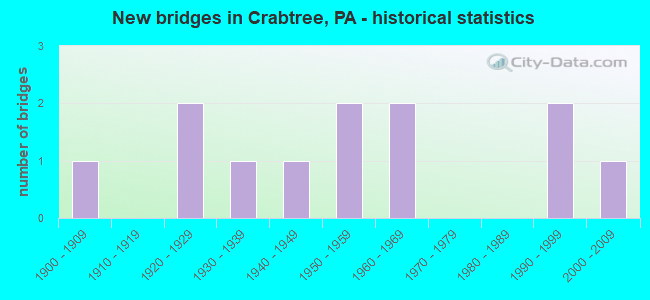
- New bridges - historical statistics
- 11900-1909
- 21920-1929
- 11930-1939
- 11940-1949
- 21950-1959
- 21960-1969
- 21990-1999
- 12000-2009

- Reconstructed bridges - Historical Statistics
- 11980-1989
- 11990-1999
- 02000-2009
- 12010-2019


- Bridge Condition - Deck
- 10.0%Very good
- 50.0%Good
- 30.0%Satisfactory
- 10.0%Serious

- Bridge Condition - Superstructure
- 18.2%Very good
- 36.4%Good
- 9.1%Satisfactory
- 18.2%Poor
- 18.2%Serious

- Bridge Condition - Substructure
- 36.4%Good
- 36.4%Satisfactory
- 9.1%Poor
- 9.1%Serious
- 9.1%Imminent failure

- Bridge Condition - Channel
- 10.0%Good
- 20.0%Satisfactory
- 50.0%Fair
- 20.0%Poor
Find on map >> Show street view
Structure Number: 35912, Location: SALEM TOWNSHIP (Lat: 40.396969, Lng: -79.479419), Route carried "on" structure: US 22, Year Built: 1949, Year Reconstructed: 1995, Status: Open, Structure Length: 1.22m (4.00ft), Average Daily Traffic: 21,743 (year 2020), Truck Traffic: 20%, Average Future Daily Traffic: 19,832 (year 2032), Design Load: HS 25 or greater, Features Intersected: WHITETHORN CREEK
Minimum Vertical Clearance: 30+ m (98+ ft), Kilometerpoint: 19.909, Lanes on structure: 3, Base Highway Network: Yes, Owner: State Highway Agency, Approaching Roadway Width: 16.2m (53.1ft), Skew: 2 degrees, Material/Design: Concrete, Design/Construction: Culvert, Number Of Spans In Main Unit: 1, Length of Maximum Span: 9.8m (32.2ft)
Condition: Channel: Fair, Culverts: Fair, Inventory Rating: 99.8 metric tons, Method Used To Determine Inventory Rating: Field evaluation and documented engineering judgment, Structural Evaluation: Somewhat better than minimum adequacy, Waterway Adequacy: Superior to present desirable criteria, Approach Roadway Alignment: Equal to present desirable criteria, Length Of Structure Improvement: 0.90m (2.95ft), Designated Inspection Frequency: Every 24 months, Inspection Date: April 2021, Bridge Improvement Cost: $25,000, Roadway Improvement Cost: $150,000, Total Project Cost: $333,000
Find on map >> Show street view
Structure Number: 36106, Location: UNITY & SALEM TOWNSHIP (Lat: 40.363114, Lng: -79.469775), Route carried "on" structure: US 119, Year Built: 1994, Status: Open, Structure Length: 1.49m (4.89ft), Average Daily Traffic: 5,073 (year 2020), Truck Traffic: 11%, Average Future Daily Traffic: 7,859 (year 2032), Design Load: HS 25 or greater, Features Intersected: CRABTREE CREEK
Minimum Vertical Clearance: 30+ m (98+ ft), Kilometerpoint: 32.774, Lanes on structure: 2, Base Highway Network: Yes, Owner: State Highway Agency, Approaching Roadway Width: 11.0m (36.1ft), Skew: 3 degrees, Material/Design: Prestressed concrete, Design/Construction: Box Beam or Girders - Multiple, Number Of Spans In Main Unit: 1, Length of Maximum Span: 14.6m (47.9ft), Curb or Sidewalk Widths: Left: 0.2m (0.7ft), Right: 1.7m (5.6ft), Curb-To-Curb Width: 11.0m (36.1ft), Out-to-Out Width: 13.5m (44.3ft)
Condition: Deck: Satisfactory, Superstructure: Very good, Substructure: Good, Channel: Fair, Operating Rating: 89.8 metric tons, Method Used To Determine Operating Rating: Load Factor (LF), Inventory Rating: 34.5 metric tons, Method Used To Determine Inventory Rating: Load Factor (LF), Structural Evaluation: Better than present minimum criteria, Deck Geometry: Meets minimum limits, Waterway Adequacy: Better than present minimum criteria, Approach Roadway Alignment: Equal to present desirable criteria, Length Of Structure Improvement: 1.30m (4.27ft), Designated Inspection Frequency: Every 24 months, Inspection Date: May 2021, Bridge Improvement Cost: $42,000, Roadway Improvement Cost: $150,000, Total Project Cost: $567,000, Deck Structure Type: Concrete Cast-file-Place, Wearing Surface/Protective System: Wearing Surface: Monolithic Concrete, Deck Protection: Epoxy Coated Reinforcing
Find on map >> Show street view
Structure Number: 36402, Location: SALEM TOWNSHIP (Lat: 40.393228, Lng: -79.480758), Route carried "on" structure: State highway , Year Built: 1966, Status: Open, Structure Length: 0.94m (3.08ft), Average Daily Traffic: 167 (year 2022), Truck Traffic: 14%, Average Future Daily Traffic: 248 (year 2032), Design Load: HS 20+Mod, Features Intersected: WHITETHORN CREEK, Facility Carried by Structure: SR 1022
Minimum Vertical Clearance: 30+ m (98+ ft), Kilometerpoint: 0.000, Lanes on structure: 2, Owner: State Highway Agency, Approaching Roadway Width: 12.9m (42.3ft), Skew: 1 degrees, Material/Design: Concrete, Design/Construction: Slab, Number Of Spans In Main Unit: 1, Length of Maximum Span: 8.8m (28.9ft), Curb or Sidewalk Widths: Left: 0.5m (1.6ft), Right: 0.5m (1.6ft), Curb-To-Curb Width: 10.6m (34.8ft), Out-to-Out Width: 12.0m (39.4ft)
Condition: Deck: Good, Superstructure: Good, Substructure: Satisfactory, Channel: Fair, Operating Rating: 65.3 metric tons, Method Used To Determine Operating Rating: Load Factor (LF), Inventory Rating: 48.1 metric tons, Method Used To Determine Inventory Rating: Load Factor (LF), Structural Evaluation: Equal to present minimum criteria, Deck Geometry: Better than present minimum criteria, Waterway Adequacy: Better than present minimum criteria, Approach Roadway Alignment: Equal to present desirable criteria, Length Of Structure Improvement: 1.60m (5.25ft), Designated Inspection Frequency: Every 48 months, Inspection Date: December 2019, Wearing Surface/Protective System: Wearing Surface: Monolithic Concrete
Find on map >> Show street view
Structure Number: 36403, Location: SALEM TOWNSHIP (Lat: 40.362236, Lng: -79.471753), Route carried "on" structure: State highway , Year Built: 1966, Year Reconstructed: 2017, Status: Open, Structure Length: 1.62m (5.31ft), Average Daily Traffic: 167 (year 2022), Truck Traffic: 14%, Average Future Daily Traffic: 248 (year 2032), Design Load: HS 20, Features Intersected: CRABTREE CREEK, Facility Carried by Structure: SR 1022
Minimum Vertical Clearance: 30+ m (98+ ft), Kilometerpoint: 3.885, Lanes on structure: 2, Owner: State Highway Agency, Approaching Roadway Width: 6.1m (20.0ft), Skew: 1 degrees, Material/Design: Prestressed concrete, Design/Construction: Box Beam or Girders - Multiple, Number Of Spans In Main Unit: 1, Length of Maximum Span: 15.8m (51.8ft), Curb-To-Curb Width: 10.5m (34.4ft), Out-to-Out Width: 11.1m (36.4ft)
Condition: Deck: Very good, Superstructure: Satisfactory, Substructure: Good, Channel: Satisfactory, Inventory Rating: 52.6 metric tons, Method Used To Determine Inventory Rating: Load Factor (LF), Structural Evaluation: Equal to present minimum criteria, Deck Geometry: Better than present minimum criteria, Waterway Adequacy: Superior to present desirable criteria, Approach Roadway Alignment: Equal to present desirable criteria, Length Of Structure Improvement: 2.30m (7.55ft), Designated Inspection Frequency: Every 48 months, Inspection Date: December 2019, Deck Structure Type: Concrete Cast-file-Place, Wearing Surface/Protective System: Wearing Surface: Monolithic Concrete, Deck Protection: Epoxy Coated Reinforcing
Find on map >> Show street view
Structure Number: 36413, Location: UNITY TOWNSHIP (Lat: 40.313942, Lng: -79.465317), Route carried "on" structure: State highway , Year Built: 1991, Status: Open, Structure Length: 8.02m (26.31ft), Average Daily Traffic: 4,836 (year 2022), Truck Traffic: 1%, Average Future Daily Traffic: 6,172 (year 2032), Design Load: HS 25 or greater, Features Intersected: Norfolk Sothern Railway, Facility Carried by Structure: SR 1026
Minimum Vertical Clearance: 30+ m (98+ ft), Kilometerpoint: 4.072, Lanes on structure: 2, Owner: State Highway Agency, Approaching Roadway Width: 12.2m (40.0ft), Skew: 4 degrees, Material/Design: Prestressed concrete continuous, Design/Construction: Stringer/Multi-beam, Number Of Spans In Main Unit: 3, Length of Maximum Span: 29.9m (98.1ft), Curb-To-Curb Width: 12.2m (40.0ft), Out-to-Out Width: 13.3m (43.6ft)
Condition: Deck: Good, Superstructure: Good, Substructure: Good, Operating Rating: 83.5 metric tons, Method Used To Determine Operating Rating: Load Factor (LF), Inventory Rating: 41.7 metric tons, Method Used To Determine Inventory Rating: Load Factor (LF), Structural Evaluation: Better than present minimum criteria, Deck Geometry: Equal to present minimum criteria, Underclear: High priority of replacement, Approach Roadway Alignment: Better than present minimum criteria, Length Of Structure Improvement: 8.90m (29.20ft), Designated Inspection Frequency: Every 48 months, Inspection Date: October 2021, Bridge Improvement Cost: $321,000, Roadway Improvement Cost: $946,000, Total Project Cost: $4,336,000, Deck Structure Type: Concrete Cast-file-Place, Wearing Surface/Protective System: Wearing Surface: Monolithic Concrete, Deck Protection: Epoxy Coated Reinforcing
Find on map >> Show street view
Structure Number: 36421, Location: UNITY TOWNSHIP (Lat: 40.338508, Lng: -79.463353), Route carried "on" structure: State highway , Year Built: 1950, Status: Open, Structure Length: 1.16m (3.81ft), Average Daily Traffic: 960 (year 2022), Truck Traffic: 1%, Average Future Daily Traffic: 1,390 (year 2032), Design Load: HS 20+Mod, Features Intersected: LITTLE CRABTREE CREEK, Facility Carried by Structure: SR 1028
Minimum Vertical Clearance: 30+ m (98+ ft), Kilometerpoint: 5.349, Lanes on structure: 2, Owner: State Highway Agency, Approaching Roadway Width: 6.7m (22.0ft), Material/Design: Concrete, Design/Construction: Tee Beam, Number Of Spans In Main Unit: 1, Length of Maximum Span: 11.0m (36.1ft), Curb or Sidewalk Widths: Left: 0.2m (0.7ft), Right: 0.2m (0.7ft), Curb-To-Curb Width: 7.3m (24.0ft), Out-to-Out Width: 8.4m (27.6ft)
Condition: Deck: Good, Superstructure: Good, Substructure: Satisfactory, Channel: Fair, Operating Rating: 53.5 metric tons, Method Used To Determine Operating Rating: Load Factor (LF), Inventory Rating: 31.8 metric tons, Method Used To Determine Inventory Rating: Load Factor (LF), Structural Evaluation: Equal to present minimum criteria, Deck Geometry: Meets minimum limits, Waterway Adequacy: Equal to present minimum criteria, Approach Roadway Alignment: Equal to present desirable criteria, Length Of Structure Improvement: 1.80m (5.91ft), Designated Inspection Frequency: Every 24 months, Inspection Date: December 2019, Deck Structure Type: Concrete Cast-file-Place, Wearing Surface/Protective System: Wearing Surface: Bituminous, Membrane: Preformed Fabric
Find on map >> Show street view
Structure Number: 36422, Location: UNITY TOWNSHIP (Lat: 40.338833, Lng: -79.460753), Route carried "on" structure: State highway , Year Built: 1950, Status: Open, Structure Length: 0.64m (2.10ft), Average Daily Traffic: 960 (year 2022), Truck Traffic: 1%, Average Future Daily Traffic: 1,390 (year 2032), Design Load: HS 20+Mod, Features Intersected: LITTLE CRABTREE CREEK, Facility Carried by Structure: SR 1028
Minimum Vertical Clearance: 30+ m (98+ ft), Kilometerpoint: 5.349, Lanes on structure: 2, Owner: State Highway Agency, Approaching Roadway Width: 7.3m (24.0ft), Skew: 1 degrees, Material/Design: Concrete, Design/Construction: Slab, Number Of Spans In Main Unit: 1, Length of Maximum Span: 5.8m (19.0ft), Curb or Sidewalk Widths: Left: 0.2m (0.7ft), Right: 0.2m (0.7ft), Curb-To-Curb Width: 7.3m (24.0ft), Out-to-Out Width: 8.4m (27.6ft)
Condition: Deck: Good, Superstructure: Good, Substructure: Satisfactory, Channel: Fair, Operating Rating: 45.4 metric tons, Method Used To Determine Operating Rating: Load Factor (LF), Inventory Rating: 27.2 metric tons, Method Used To Determine Inventory Rating: Load Factor (LF), Structural Evaluation: Equal to present minimum criteria, Deck Geometry: Meets minimum limits, Waterway Adequacy: Superior to present desirable criteria, Approach Roadway Alignment: Equal to present desirable criteria, Length Of Structure Improvement: 1.20m (3.94ft), Designated Inspection Frequency: Every 24 months, Inspection Date: December 2019, Wearing Surface/Protective System: Wearing Surface: Bituminous, Membrane: Preformed Fabric
Find on map >> Show street view
Structure Number: 36441, Location: UNITY & HEMPFIELD TWPS. (Lat: 40.328339, Lng: -79.475047), Route carried "on" structure: State highway , Year Built: 1929, Status: Open, Structure Length: 0.88m (2.89ft), Average Daily Traffic: 524 (year 2020), Truck Traffic: 5%, Average Future Daily Traffic: 337 (year 2032), Design Load: H 15, Features Intersected: LITTLE CRABTREE CREEK, Facility Carried by Structure: SR 1051
Minimum Vertical Clearance: 30+ m (98+ ft), Kilometerpoint: 0.557, Lanes on structure: 1, Owner: State Highway Agency, Approaching Roadway Width: 4.3m (14.1ft), Material/Design: Concrete, Design/Construction: Arch - Deck, Number Of Spans In Main Unit: 1, Length of Maximum Span: 7.6m (24.9ft), Curb-To-Curb Width: 4.3m (14.1ft), Out-to-Out Width: 5.4m (17.7ft)
Condition: Superstructure: Poor, Substructure: Poor, Channel: Satisfactory, Operating Rating: 58.1 metric tons, Method Used To Determine Operating Rating: Field evaluation and documented engineering judgment, Inventory Rating: 34.5 metric tons, Method Used To Determine Inventory Rating: Field evaluation and documented engineering judgment, Structural Evaluation: Meets minimum limits, Deck Geometry: High priority of replacement, Waterway Adequacy: Superior to present desirable criteria, Approach Roadway Alignment: Equal to present desirable criteria, Length Of Structure Improvement: 1.50m (4.92ft), Designated Inspection Frequency: Every 24 months, Inspection Date: December 2019, Bridge Improvement Cost: $9,000, Roadway Improvement Cost: $26,000, Total Project Cost: $119,000
Find on map >> Show street view
Structure Number: 36952, Location: 200' EAST OF SR 1055 (Lat: 40.397764, Lng: -79.479197), Route carried "on" structure: City street T628, Year Built: 1924, Status: Posted for load, Structure Length: 0.73m (2.40ft), Average Daily Traffic: 20 (year 1992), Truck Traffic: 5%, Average Future Daily Traffic: 25 (year 2010), Design Load: H 15, Features Intersected: WHITEHORN CREEK, Facility Carried by Structure: OLD WLM. PENN HWY
Minimum Vertical Clearance: 30+ m (98+ ft), Kilometerpoint: 0.000, Lanes on structure: 2, Base Highway Network: Yes, Owner: Town or Township Highway Agency, Approaching Roadway Width: 4.9m (16.1ft), Skew: 1 degrees, Material/Design: Concrete, Design/Construction: Tee Beam, Number Of Spans In Main Unit: 1, Length of Maximum Span: 6.4m (21.0ft), Curb-To-Curb Width: 3.2m (10.5ft), Out-to-Out Width: 7.9m (25.9ft)
Condition: Deck: Serious, Superstructure: Serious, Substructure: Serious, Channel: Poor, Operating Rating: 20.0 metric tons, Method Used To Determine Operating Rating: Load Factor (LF), Inventory Rating: 11.8 metric tons, Method Used To Determine Inventory Rating: Load Factor (LF), Structural Evaluation: High priority of corrective action, Deck Geometry: High priority of replacement, Waterway Adequacy: Equal to present minimum criteria, Approach Roadway Alignment: Equal to present desirable criteria, Bridge Posting: Required (Relationship of Operating Rating to Maximum Legal Load: > 39.9% below), Length Of Structure Improvement: 0.80m (2.62ft), Designated Inspection Frequency: Every 24 months, Underwater Inspection Frequency: Every 24 months, Other Special Inspection Frequency: Every 12 months, Inspection Date: October 2020, Underwater Inspection Date: August 2020, Other Special Inspection Date: October 2021, Bridge Improvement Cost: $6,000, Roadway Improvement Cost: $37,000, Total Project Cost: $78,000, Deck Structure Type: Concrete Cast-file-Place, Wearing Surface/Protective System: Wearing Surface: Bituminous
Find on map >> Show street view
Structure Number: 36969, Location: 1 MI N OF MT VIEW SCHOOL (Lat: 40.312300, Lng: -79.459697), Route carried "on" structure: City street , Year Built: 1906, Year Reconstructed: 1994, Status: Closed, Structure Length: 2.83m (9.28ft), Average Daily Traffic: 200 (year 2005), Truck Traffic: 1%, Average Future Daily Traffic: 70 (year 2010), Design Load: H 15, Features Intersected: NS RR MAINLINE, Facility Carried by Structure: BUFFENMEYER ROAD
Minimum Vertical Clearance: 30+ m (98+ ft), Kilometerpoint: 0.000, Lanes on structure: 2, Owner: Railroad, Approaching Roadway Width: 5.5m (18.0ft), Material/Design: Steel, Design/Construction: Truss - Thru, Number Of Spans In Main Unit: 1, Length of Maximum Span: 28.3m (92.8ft), Curb-To-Curb Width: 5.5m (18.0ft), Out-to-Out Width: 6.7m (22.0ft)
Condition: Deck: Satisfactory, Superstructure: Serious, Substructure: Satisfactory, Operating Rating: 6.4 metric tons, Method Used To Determine Operating Rating: Allowable Stress (AS), Deck Geometry: High priority of corrective action, Approach Roadway Alignment: Somewhat better than minimum adequacy, Bridge Posting: Required (Relationship of Operating Rating to Maximum Legal Load: > 39.9% below), Length Of Structure Improvement: 3.60m (11.81ft), Designated Inspection Frequency: Every 24 months, Inspection Date: April 2021, Bridge Improvement Cost: $14,000, Roadway Improvement Cost: $40,000, Total Project Cost: $186,000, Deck Structure Type: Wood or Timber, Wearing Surface/Protective System: Wearing Surface: Bituminous
Find on map >> Show street view
Structure Number: 4118, Location: HEMPFIELD @ UNITY TWP. (Lat: 40.357264, Lng: -79.472125), Route carried "on" structure: US 119, Year Built: 2000, Status: Open, Structure Length: 1.07m (3.51ft), Average Daily Traffic: 5,073 (year 2020), Truck Traffic: 11%, Average Future Daily Traffic: 7,859 (year 2032), Design Load: HS 25 or greater, Features Intersected: LITTLE CRABTREE CREEK
Minimum Vertical Clearance: 30+ m (98+ ft), Kilometerpoint: 32.774, Lanes on structure: 2, Base Highway Network: Yes, Owner: State Highway Agency, Approaching Roadway Width: 12.2m (40.0ft), Skew: 1 degrees, Material/Design: Prestressed concrete, Design/Construction: Box Beam or Girders - Single/Spread, Number Of Spans In Main Unit: 1, Length of Maximum Span: 10.7m (35.1ft), Curb or Sidewalk Widths: Left: 0.2m (0.7ft), Right: 0.2m (0.7ft), Curb-To-Curb Width: 12.2m (40.0ft), Out-to-Out Width: 13.1m (43.0ft)
Condition: Deck: Good, Superstructure: Very good, Substructure: Good, Channel: Good, Inventory Rating: 46.3 metric tons, Method Used To Determine Inventory Rating: Load Factor (LF), Structural Evaluation: Better than present minimum criteria, Deck Geometry: Somewhat better than minimum adequacy, Waterway Adequacy: Superior to present desirable criteria, Approach Roadway Alignment: Better than present minimum criteria, Length Of Structure Improvement: 1.80m (5.91ft), Designated Inspection Frequency: Every 48 months, Inspection Date: May 2019, Deck Structure Type: Concrete Cast-file-Place, Wearing Surface/Protective System: Wearing Surface: Monolithic Concrete, Deck Protection: Epoxy Coated Reinforcing
Find on map >> Show street view
Structure Number: 41357, Location: AT SR1022 IN GREENWALD (Lat: 40.362025, Lng: -79.454775), Route carried "on" structure: City street T854, Year Built: 1930, Status: Closed, Structure Length: 1.01m (3.31ft), Features Intersected: CRABTREE CREEK, Facility Carried by Structure: T-854 KILEY DRIVE
Minimum Vertical Clearance: 30+ m (98+ ft), Kilometerpoint: 0.000, Lanes on structure: 2, Owner: City or Municipal Highway Agency, Approaching Roadway Width: 4.6m (15.1ft), Material/Design: Steel, Design/Construction: Stringer/Multi-beam, Number Of Spans In Main Unit: 1, Length of Maximum Span: 9.4m (30.8ft), Curb-To-Curb Width: 5.0m (16.4ft), Out-to-Out Width: 5.4m (17.7ft)
Condition: Deck: Satisfactory, Superstructure: Poor, Substructure: Imminent failure, Channel: Poor, Deck Geometry: High priority of corrective action, Waterway Adequacy: Equal to present desirable criteria, Approach Roadway Alignment: Better than present minimum criteria, Bridge Posting: Required (Relationship of Operating Rating to Maximum Legal Load: > 39.9% below), Length Of Structure Improvement: 1.20m (3.94ft), Designated Inspection Frequency: Every 24 months, Inspection Date: Febuary 2021, Bridge Improvement Cost: $16,000, Roadway Improvement Cost: $50,000, Total Project Cost: $216,000, Deck Structure Type: Concrete Cast-file-Place, Wearing Surface/Protective System: Wearing Surface: Bituminous