Bridge Statistics for Craig, Iowa (IA)
Condition, Traffic, Stress, Structural Evaluation, Project Costs
- National Bridge Inventory (NBI) Statistics
- 17Number of bridges
- 75ft / 23.2mTotal length
- 1,765Total average daily traffic
- 339Total average daily truck traffic
- 1,765Total future (year 2040) average daily traffic
- National Bridge Inventory (NBI) Registered Bridges for Craig
- No street view available for this location
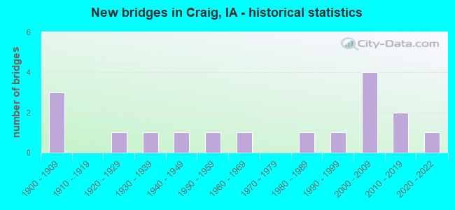
- New bridges - historical statistics
- 31900-1909
- 11920-1929
- 11930-1939
- 11940-1949
- 11950-1959
- 11960-1969
- 11980-1989
- 11990-1999
- 42000-2009
- 22010-2019
- 12020-2022

- Bridge Condition - Deck
- 7.7%Excellent
- 30.8%Very good
- 23.1%Good
- 23.1%Satisfactory
- 7.7%Fair
- 7.7%Poor

- Bridge Condition - Superstructure
- 7.7%Excellent
- 38.5%Very good
- 23.1%Satisfactory
- 23.1%Fair
- 7.7%Poor

- Bridge Condition - Substructure
- 7.7%Excellent
- 38.5%Very good
- 15.4%Fair
- 38.5%Poor

- Bridge Condition - Channel
- 58.8%Very good
- 5.9%Good
- 11.8%Satisfactory
- 23.5%Fair

- Bridge Condition - Culverts
- 50.0%Very good
- 25.0%Good
- 25.0%Satisfactory
Find on map >> Show street view
Structure Number: 1891, Location: 079092602 (Lat: 41.623736, Lng: -91.871553), Route carried "on" structure: County highway , Year Built: 1920, Status: Posted for load-capacity, Structure Length: 0.88m (2.89ft), Average Daily Traffic: 100 (year 2018), Average Future Daily Traffic: 100 (year 2040), Features Intersected: CONVEY CREEK, Facility Carried by Structure: LOCAL
Minimum Vertical Clearance: 30+ m (98+ ft), Kilometerpoint: 3.277, Lanes on structure: 1, Owner: County Highway Agency, Approaching Roadway Width: 8.2m (26.9ft), Material/Design: Steel, Design/Construction: Stringer/Multi-beam, Number Of Spans In Main Unit: 1, Length of Maximum Span: 8.8m (28.9ft), Curb-To-Curb Width: 4.8m (15.7ft), Out-to-Out Width: 4.9m (16.1ft)
Condition: Deck: Poor, Superstructure: Poor, Substructure: Fair, Channel: Fair, Operating Rating: 42.1 metric tons, Method Used To Determine Operating Rating: Allowable Stress (AS), Inventory Rating: 24.9 metric tons, Method Used To Determine Inventory Rating: Allowable Stress (AS), Structural Evaluation: Meets minimum limits, Deck Geometry: Equal to present desirable criteria, Waterway Adequacy: Somewhat better than minimum adequacy, Approach Roadway Alignment: Better than present minimum criteria, Length Of Structure Improvement: 7.00m (22.97ft), Designated Inspection Frequency: Every 24 months, Inspection Date: March 2020, Bridge Improvement Cost: $189,000, Roadway Improvement Cost: $19,000, Deck Structure Type: Concrete Cast-file-Place, Wearing Surface/Protective System: Wearing Surface: Gravel
Find on map >> Show street view
Structure Number: 27688, Location: 093460202 (Lat: 42.899775, Lng: -96.253392), Route carried "on" structure: County highway , Year Built: 1948, Status: Posted for load, Structure Length: 0.91m (2.99ft), Average Daily Traffic: 35 (year 2019), Average Future Daily Traffic: 35 (year 2041), Features Intersected: MINK CREEK, Facility Carried by Structure: JUNIPER AVE
Minimum Vertical Clearance: 30+ m (98+ ft), Kilometerpoint: 30.143, Lanes on structure: 2, Owner: County Highway Agency, Approaching Roadway Width: 7.3m (24.0ft), Material/Design: Wood or Timber, Design/Construction: Stringer/Multi-beam, Number Of Spans In Main Unit: 2, Length of Maximum Span: 4.6m (15.1ft), Curb-To-Curb Width: 6.1m (20.0ft), Out-to-Out Width: 6.1m (20.0ft)
Condition: Deck: Good, Superstructure: Satisfactory, Substructure: Poor, Channel: Fair, Operating Rating: 30.0 metric tons, Method Used To Determine Operating Rating: Load Factor (LF), Inventory Rating: 20.9 metric tons, Method Used To Determine Inventory Rating: Load Factor (LF), Structural Evaluation: Meets minimum limits, Deck Geometry: Somewhat better than minimum adequacy, Waterway Adequacy: Better than present minimum criteria, Approach Roadway Alignment: Equal to present desirable criteria, Bridge Posting: Required (Relationship of Operating Rating to Maximum Legal Load: 30.0 - 39.9% below), Length Of Structure Improvement: 4.60m (15.09ft), Designated Inspection Frequency: Every 24 months, Inspection Date: July 2021, Bridge Improvement Cost: $138,000, Roadway Improvement Cost: $20,000, Deck Structure Type: Wood or Timber, Wearing Surface/Protective System: Wearing Surface: Gravel
Find on map >> Show street view
Structure Number: 27695, Location: 093461102 (Lat: 42.890436, Lng: -96.253383), Route carried "on" structure: County highway , Year Built: 1900, Status: Posted for load, Structure Length: 0.91m (2.99ft), Average Daily Traffic: 45 (year 2019), Average Future Daily Traffic: 45 (year 2041), Features Intersected: MINK CREEK, Facility Carried by Structure: JUNIPER AVE
Minimum Vertical Clearance: 30+ m (98+ ft), Kilometerpoint: 29.105, Lanes on structure: 2, Owner: County Highway Agency, Approaching Roadway Width: 7.6m (24.9ft), Material/Design: Wood or Timber, Design/Construction: Stringer/Multi-beam, Number Of Spans In Main Unit: 2, Length of Maximum Span: 4.6m (15.1ft), Curb-To-Curb Width: 6.2m (20.3ft), Out-to-Out Width: 6.2m (20.3ft)
Condition: Deck: Satisfactory, Superstructure: Satisfactory, Substructure: Poor, Channel: Satisfactory, Operating Rating: 30.7 metric tons, Method Used To Determine Operating Rating: Load Factor (LF), Inventory Rating: 21.4 metric tons, Method Used To Determine Inventory Rating: Load Factor (LF), Structural Evaluation: Meets minimum limits, Deck Geometry: Somewhat better than minimum adequacy, Waterway Adequacy: Equal to present desirable criteria, Approach Roadway Alignment: Equal to present minimum criteria, Length Of Structure Improvement: 4.60m (15.09ft), Designated Inspection Frequency: Every 24 months, Inspection Date: July 2021, Bridge Improvement Cost: $138,000, Roadway Improvement Cost: $20,000, Deck Structure Type: Wood or Timber, Wearing Surface/Protective System: Wearing Surface: Gravel
Find on map >> Show street view
Structure Number: 27698, Location: 093461502 (Lat: 42.870436, Lng: -96.272925), Route carried "on" structure: County highway , Year Built: 1961, Status: Posted for load, Structure Length: 3.14m (10.30ft), Average Daily Traffic: 560 (year 2019), Truck Traffic: 31%, Average Future Daily Traffic: 560 (year 2041), Design Load: H 15, Features Intersected: MINK CREEK, Facility Carried by Structure: FM
Minimum Vertical Clearance: 30+ m (98+ ft), Kilometerpoint: 18.670, Lanes on structure: 2, Owner: County Highway Agency, Approaching Roadway Width: 11.0m (36.1ft), Skew: 3 degrees, Material/Design: Concrete continuous, Design/Construction: Slab, Number Of Spans In Main Unit: 3, Number Of Approach Spans: 2, Length of Maximum Span: 11.9m (39.0ft), Curb-To-Curb Width: 7.3m (24.0ft), Out-to-Out Width: 8.0m (26.2ft)
Condition: Deck: Satisfactory, Superstructure: Very good, Substructure: Very good, Channel: Good, Operating Rating: 35.9 metric tons, Method Used To Determine Operating Rating: Load Factor (LF), Inventory Rating: 21.5 metric tons, Method Used To Determine Inventory Rating: Load Factor (LF), Structural Evaluation: Somewhat better than minimum adequacy, Deck Geometry: Meets minimum limits, Waterway Adequacy: Equal to present desirable criteria, Approach Roadway Alignment: Equal to present minimum criteria, Bridge Posting: Required (Relationship of Operating Rating to Maximum Legal Load: 0.1 - 9.9% below), Length Of Structure Improvement: 12.00m (39.37ft), Designated Inspection Frequency: Every 24 months, Inspection Date: July 2021, Bridge Improvement Cost: $360,000, Roadway Improvement Cost: $30,000, Deck Structure Type: Concrete Cast-file-Place, Wearing Surface/Protective System: Wearing Surface: Monolithic Concrete
Find on map >> Show street view
Structure Number: 276991, Location: 093461503 (Lat: 42.879869, Lng: -96.262267), Route carried "on" structure: County highway , Year Built: 2003, Status: Open, Structure Length: 1.25m (4.10ft), Average Daily Traffic: 25 (year 2019), Average Future Daily Traffic: 25 (year 2041), Design Load: HS 20, Features Intersected: MINK CREEK, Facility Carried by Structure: 120TH ST
Minimum Vertical Clearance: 30+ m (98+ ft), Kilometerpoint: 21.156, Lanes on structure: 2, Owner: County Highway Agency, Approaching Roadway Width: 8.5m (27.9ft), Material/Design: Concrete, Design/Construction: Slab, Number Of Spans In Main Unit: 1, Length of Maximum Span: 12.5m (41.0ft), Curb-To-Curb Width: 9.6m (31.5ft), Out-to-Out Width: 10.2m (33.5ft)
Condition: Deck: Very good, Superstructure: Very good, Substructure: Very good, Channel: Very good, Operating Rating: 55.3 metric tons, Method Used To Determine Operating Rating: Load Factor (LF), Inventory Rating: 32.7 metric tons, Method Used To Determine Inventory Rating: Load Factor (LF), Structural Evaluation: Equal to present desirable criteria, Deck Geometry: Better than present minimum criteria, Waterway Adequacy: Equal to present desirable criteria, Approach Roadway Alignment: Equal to present desirable criteria, Length Of Structure Improvement: 4.20m (13.78ft), Designated Inspection Frequency: Every 24 months, Inspection Date: July 2021, Bridge Improvement Cost: $126,000, Roadway Improvement Cost: $10,000, Deck Structure Type: Concrete Cast-file-Place, Wearing Surface/Protective System: Wearing Surface: Monolithic Concrete
Find on map >> Show street view
Structure Number: 277, Location: 093461601 (Lat: 42.880033, Lng: -96.291589), Route carried "on" structure: County highway , Year Built: 1900, Status: Open, Structure Length: 0.94m (3.08ft), Average Daily Traffic: 30 (year 2019), Average Future Daily Traffic: 30 (year 2041), Design Load: HS 20, Features Intersected: DRAINAGE, Facility Carried by Structure: 120TH ST
Minimum Vertical Clearance: 30+ m (98+ ft), Kilometerpoint: 18.760, Lanes on structure: 2, Owner: County Highway Agency, Approaching Roadway Width: 7.9m (25.9ft), Material/Design: Wood or Timber, Design/Construction: Stringer/Multi-beam, Number Of Spans In Main Unit: 2, Number Of Approach Spans: 1, Length of Maximum Span: 4.6m (15.1ft), Curb-To-Curb Width: 6.1m (20.0ft), Out-to-Out Width: 6.1m (20.0ft)
Condition: Deck: Satisfactory, Superstructure: Fair, Substructure: Poor, Channel: Fair, Operating Rating: 33.4 metric tons, Method Used To Determine Operating Rating: Allowable Stress (AS), Inventory Rating: 23.5 metric tons, Method Used To Determine Inventory Rating: Allowable Stress (AS), Structural Evaluation: Meets minimum limits, Deck Geometry: Somewhat better than minimum adequacy, Waterway Adequacy: Equal to present desirable criteria, Approach Roadway Alignment: Equal to present desirable criteria, Length Of Structure Improvement: 4.60m (15.09ft), Designated Inspection Frequency: Every 24 months, Inspection Date: July 2021, Bridge Improvement Cost: $138,000, Roadway Improvement Cost: $10,000, Deck Structure Type: Wood or Timber, Wearing Surface/Protective System: Wearing Surface: Gravel
Find on map >> Show street view
Structure Number: 277011, Location: 000000000 (Lat: 42.872261, Lng: -96.292622), Route carried "on" structure: County highway , Year Built: 2009, Status: Open, Structure Length: 2.83m (9.28ft), Average Daily Traffic: 30 (year 2019), Average Future Daily Traffic: 30 (year 2041), Design Load: HS 20, Features Intersected: MINK CREEK, Facility Carried by Structure: IRIS AVE
Minimum Vertical Clearance: 30+ m (98+ ft), Kilometerpoint: 19.330, Lanes on structure: 2, Owner: County Highway Agency, Approaching Roadway Width: 9.1m (29.9ft), Material/Design: Concrete, Design/Construction: Slab, Number Of Spans In Main Unit: 3, Number Of Approach Spans: 2, Length of Maximum Span: 10.7m (35.1ft), Curb-To-Curb Width: 9.1m (29.9ft), Out-to-Out Width: 9.1m (29.9ft)
Condition: Deck: Very good, Superstructure: Very good, Substructure: Very good, Channel: Very good, Operating Rating: 66.8 metric tons, Method Used To Determine Operating Rating: Load Factor (LF), Inventory Rating: 40.0 metric tons, Method Used To Determine Inventory Rating: Load Factor (LF), Structural Evaluation: Equal to present desirable criteria, Deck Geometry: Better than present minimum criteria, Waterway Adequacy: Equal to present desirable criteria, Approach Roadway Alignment: Equal to present desirable criteria, Designated Inspection Frequency: Every 24 months, Inspection Date: July 2021, Deck Structure Type: Concrete Cast-file-Place, Wearing Surface/Protective System: Wearing Surface: Monolithic Concrete
Find on map >> Show street view
Structure Number: 277031, Location: 093461701 (Lat: 42.880014, Lng: -96.295717), Route carried "on" structure: County highway , Year Built: 1999, Status: Open, Structure Length: 0.76m (2.49ft), Average Daily Traffic: 50 (year 2019), Average Future Daily Traffic: 50 (year 2041), Design Load: HS 20+Mod, Features Intersected: MINK CREEK, Facility Carried by Structure: 120TH ST
Minimum Vertical Clearance: 30+ m (98+ ft), Kilometerpoint: 18.424, Lanes on structure: 2, Owner: County Highway Agency, Approaching Roadway Width: 8.5m (27.9ft), Skew: 4 degrees, Material/Design: Concrete, Design/Construction: Culvert, Number Of Spans In Main Unit: 2, Length of Maximum Span: 3.7m (12.1ft)
Condition: Channel: Very good, Culverts: Good, Operating Rating: 47.2 metric tons, Method Used To Determine Operating Rating: Load Factor (LF), Inventory Rating: 28.2 metric tons, Method Used To Determine Inventory Rating: Load Factor (LF), Structural Evaluation: Better than present minimum criteria, Waterway Adequacy: Equal to present desirable criteria, Approach Roadway Alignment: Equal to present desirable criteria, Length Of Structure Improvement: 2.50m (8.20ft), Designated Inspection Frequency: Every 24 months, Inspection Date: July 2021, Bridge Improvement Cost: $75,000, Roadway Improvement Cost: $10,000
Find on map >> Show street view
Structure Number: 277041, Location: 093462101 (Lat: 42.865481, Lng: -96.287772), Route carried "on" structure: County highway , Year Built: 2002, Status: Open, Structure Length: 2.68m (8.79ft), Average Daily Traffic: 60 (year 2019), Average Future Daily Traffic: 60 (year 2041), Design Load: HS 20, Features Intersected: MINK CREEK, Facility Carried by Structure: 130TH ST
Minimum Vertical Clearance: 30+ m (98+ ft), Kilometerpoint: 19.594, Lanes on structure: 2, Owner: County Highway Agency, Approaching Roadway Width: 9.1m (29.9ft), Material/Design: Concrete continuous, Design/Construction: Slab, Number Of Spans In Main Unit: 3, Number Of Approach Spans: 2, Length of Maximum Span: 10.4m (34.1ft), Curb-To-Curb Width: 9.1m (29.9ft), Out-to-Out Width: 10.1m (33.1ft)
Condition: Deck: Very good, Superstructure: Very good, Substructure: Very good, Channel: Very good, Operating Rating: 75.9 metric tons, Method Used To Determine Operating Rating: Load Factor (LF), Inventory Rating: 45.4 metric tons, Method Used To Determine Inventory Rating: Load Factor (LF), Structural Evaluation: Equal to present desirable criteria, Deck Geometry: Better than present minimum criteria, Waterway Adequacy: Equal to present desirable criteria, Approach Roadway Alignment: Equal to present desirable criteria, Length Of Structure Improvement: 9.00m (29.53ft), Designated Inspection Frequency: Every 24 months, Inspection Date: July 2021, Bridge Improvement Cost: $270,000, Roadway Improvement Cost: $20,000, Deck Structure Type: Concrete Cast-file-Place, Wearing Surface/Protective System: Wearing Surface: Monolithic Concrete
Find on map >> Show street view
Structure Number: 277051, Location: 093462101 (Lat: 42.865406, Lng: -96.278092), Route carried "on" structure: County highway , Year Built: 2004, Status: Open, Structure Length: 2.29m (7.51ft), Average Daily Traffic: 60 (year 2019), Average Future Daily Traffic: 60 (year 2041), Design Load: HS 20, Features Intersected: MINK CREEK, Facility Carried by Structure: 130TH ST
Minimum Vertical Clearance: 30+ m (98+ ft), Kilometerpoint: 20.386, Lanes on structure: 2, Owner: County Highway Agency, Approaching Roadway Width: 8.5m (27.9ft), Material/Design: Concrete, Design/Construction: Slab, Number Of Spans In Main Unit: 3, Number Of Approach Spans: 2, Length of Maximum Span: 10.4m (34.1ft), Curb-To-Curb Width: 9.2m (30.2ft), Out-to-Out Width: 10.1m (33.1ft)
Condition: Deck: Very good, Superstructure: Very good, Substructure: Very good, Channel: Very good, Operating Rating: 76.3 metric tons, Method Used To Determine Operating Rating: Load Factor (LF), Inventory Rating: 45.7 metric tons, Method Used To Determine Inventory Rating: Load Factor (LF), Structural Evaluation: Equal to present desirable criteria, Deck Geometry: Better than present minimum criteria, Waterway Adequacy: Equal to present desirable criteria, Approach Roadway Alignment: Equal to present desirable criteria, Length Of Structure Improvement: 8.00m (26.25ft), Designated Inspection Frequency: Every 24 months, Inspection Date: July 2021, Bridge Improvement Cost: $240,000, Roadway Improvement Cost: $20,000, Deck Structure Type: Concrete Cast-file-Place, Wearing Surface/Protective System: Wearing Surface: Monolithic Concrete
Find on map >> Show street view
Structure Number: 27706, Location: 093462102 (Lat: 42.862283, Lng: -96.292411), Route carried "on" structure: County highway , Year Built: 1900, Status: Posted for load, Structure Length: 1.16m (3.81ft), Average Daily Traffic: 35 (year 2019), Average Future Daily Traffic: 35 (year 2041), Design Load: HS 20, Features Intersected: MINK CREEK, Facility Carried by Structure: IRIS AVE
Minimum Vertical Clearance: 30+ m (98+ ft), Kilometerpoint: 18.221, Lanes on structure: 2, Owner: County Highway Agency, Approaching Roadway Width: 7.6m (24.9ft), Material/Design: Wood or Timber, Design/Construction: Stringer/Multi-beam, Number Of Spans In Main Unit: 2, Length of Maximum Span: 5.8m (19.0ft), Curb-To-Curb Width: 6.1m (20.0ft), Out-to-Out Width: 6.1m (20.0ft)
Condition: Deck: Good, Superstructure: Fair, Substructure: Poor, Channel: Fair, Operating Rating: 26.5 metric tons, Method Used To Determine Operating Rating: Allowable Stress (AS), Inventory Rating: 18.6 metric tons, Method Used To Determine Inventory Rating: Allowable Stress (AS), Structural Evaluation: Meets minimum limits, Deck Geometry: Somewhat better than minimum adequacy, Waterway Adequacy: Equal to present desirable criteria, Approach Roadway Alignment: Equal to present minimum criteria, Bridge Posting: Required (Relationship of Operating Rating to Maximum Legal Load: 10.0 - 19.9% below), Length Of Structure Improvement: 7.00m (22.97ft), Designated Inspection Frequency: Every 24 months, Inspection Date: July 2021, Bridge Improvement Cost: $210,000, Roadway Improvement Cost: $10,000, Deck Structure Type: Wood or Timber, Wearing Surface/Protective System: Wearing Surface: Gravel
Find on map >> Show street view
Structure Number: 27713, Location: 093463002 (Lat: 42.836978, Lng: -96.331267), Route carried "on" structure: County highway , Year Built: 1951, Status: Open, Structure Length: 0.91m (2.99ft), Average Daily Traffic: 30 (year 2019), Average Future Daily Traffic: 30 (year 2041), Design Load: HS 20, Features Intersected: BROKEN KETTLE CREEK, Facility Carried by Structure: HICKORY AVE
Minimum Vertical Clearance: 30+ m (98+ ft), Kilometerpoint: 24.718, Lanes on structure: 2, Owner: County Highway Agency, Approaching Roadway Width: 7.0m (23.0ft), Material/Design: Wood or Timber, Design/Construction: Stringer/Multi-beam, Number Of Spans In Main Unit: 2, Length of Maximum Span: 4.6m (15.1ft), Curb-To-Curb Width: 6.2m (20.3ft), Out-to-Out Width: 6.2m (20.3ft)
Condition: Deck: Good, Superstructure: Satisfactory, Substructure: Poor, Channel: Satisfactory, Operating Rating: 30.7 metric tons, Method Used To Determine Operating Rating: Allowable Stress (AS), Inventory Rating: 21.6 metric tons, Method Used To Determine Inventory Rating: Allowable Stress (AS), Structural Evaluation: Meets minimum limits, Deck Geometry: Somewhat better than minimum adequacy, Waterway Adequacy: Equal to present desirable criteria, Approach Roadway Alignment: Equal to present minimum criteria, Length Of Structure Improvement: 6.00m (19.69ft), Designated Inspection Frequency: Every 12 months, Inspection Date: July 2021, Other Special Inspection Date: May 2010, Bridge Improvement Cost: $180,000, Roadway Improvement Cost: $10,000, Deck Structure Type: Wood or Timber, Wearing Surface/Protective System: Wearing Surface: Gravel
Find on map >> Show street view
Structure Number: 277391, Location: 934723011040 (Lat: 42.865675, Lng: -96.363725), Route carried "on" structure: County highway , Year Built: 2013, Status: Open, Structure Length: 0.67m (2.20ft), Average Daily Traffic: 25 (year 2019), Average Future Daily Traffic: 25 (year 2041), Design Load: HS 20, Features Intersected: BROKEN KETTLE CREEK, Facility Carried by Structure: 130TH ST
Minimum Vertical Clearance: 30+ m (98+ ft), Kilometerpoint: 13.390, Lanes on structure: 2, Owner: County Highway Agency, Approaching Roadway Width: 9.1m (29.9ft), Material/Design: Concrete, Design/Construction: Culvert, Number Of Spans In Main Unit: 1, Length of Maximum Span: 6.1m (20.0ft)
Condition: Channel: Very good, Culverts: Very good, Operating Rating: 57.7 metric tons, Method Used To Determine Operating Rating: Load and Resistance Factor Rating (LRFR) rating reported by rating factor(RF) method using HL-93 loadings, Inventory Rating: 44.4 metric tons, Method Used To Determine Inventory Rating: Load and Resistance Factor Rating (LRFR) rating reported by rating factor(RF) method using HL-93 loadings, Structural Evaluation: Equal to present desirable criteria, Approach Roadway Alignment: Equal to present desirable criteria, Designated Inspection Frequency: Every 24 months, Inspection Date: August 2021
Find on map >> Show street view
Structure Number: 309101, Location: 094462902 (Lat: 42.931139, Lng: -96.312672), Route carried "on" structure: County highway , Year Built: 2019, Status: Open, Structure Length: 0.83m (2.72ft), Average Daily Traffic: 640 (year 2019), Truck Traffic: 26%, Average Future Daily Traffic: 640 (year 2041), Design Load: HL 93, Features Intersected: SMALL STREAM, Facility Carried by Structure: K 30 EAGLE AVE
Minimum Vertical Clearance: 30+ m (98+ ft), Kilometerpoint: 2.411, Lanes on structure: 2, Owner: County Highway Agency, Approaching Roadway Width: 13.4m (44.0ft), Material/Design: Concrete, Design/Construction: Culvert, Number Of Spans In Main Unit: 2, Length of Maximum Span: 3.7m (12.1ft)
Condition: Channel: Very good, Culverts: Very good, Operating Rating: 64.2 metric tons, Method Used To Determine Operating Rating: Load and Resistance Factor Rating (LRFR) rating reported by rating factor(RF) method using HL-93 loadings, Inventory Rating: 49.2 metric tons, Method Used To Determine Inventory Rating: Load and Resistance Factor Rating (LRFR) rating reported by rating factor(RF) method using HL-93 loadings, Structural Evaluation: Equal to present desirable criteria, Waterway Adequacy: Equal to present desirable criteria, Approach Roadway Alignment: Equal to present desirable criteria, Designated Inspection Frequency: Every 24 months, Inspection Date: November 2021
Find on map >> Show street view
Structure Number: 309131, Location: 094463002 (Lat: 42.926942, Lng: -96.331925), Route carried "on" structure: County highway , Year Built: 2021, Status: Open, Structure Length: 1.38m (4.53ft), Average Daily Traffic: 15 (year 2019), Average Future Daily Traffic: 15 (year 2041), Features Intersected: SMALL STREAM, Facility Carried by Structure: DOVE AVE
Minimum Vertical Clearance: 30+ m (98+ ft), Kilometerpoint: 1.951, Lanes on structure: 2, Owner: County Highway Agency, Approaching Roadway Width: 7.3m (24.0ft), Material/Design: Wood or Timber, Design/Construction: Stringer/Multi-beam, Number Of Spans In Main Unit: 3, Length of Maximum Span: 4.6m (15.1ft), Curb-To-Curb Width: 7.0m (23.0ft), Out-to-Out Width: 7.3m (24.0ft)
Condition: Deck: Excellent, Superstructure: Excellent, Substructure: Excellent, Channel: Very good, Operating Rating: 30.3 metric tons, Method Used To Determine Operating Rating: Allowable Stress (AS), Inventory Rating: 21.0 metric tons, Method Used To Determine Inventory Rating: Allowable Stress (AS), Structural Evaluation: Equal to present minimum criteria, Deck Geometry: Somewhat better than minimum adequacy, Waterway Adequacy: Equal to present desirable criteria, Approach Roadway Alignment: Equal to present desirable criteria, Designated Inspection Frequency: Every 24 months, Inspection Date: May 2021, Deck Structure Type: Wood or Timber, Wearing Surface/Protective System: Wearing Surface: Gravel, Deck Protection: Other
Find on map >> Show street view
Structure Number: 30914, Location: 094463002 (Lat: 42.927703, Lng: -96.331925), Route carried "on" structure: County highway , Year Built: 1938, Year Reconstructed: 1976, Status: Open, Structure Length: 0.94m (3.08ft), Average Daily Traffic: 15 (year 2019), Average Future Daily Traffic: 15 (year 2040), Features Intersected: SMALL STREAM, Facility Carried by Structure: LOCAL
Minimum Vertical Clearance: 30+ m (98+ ft), Kilometerpoint: 2.034, Lanes on structure: 2, Owner: County Highway Agency, Approaching Roadway Width: 8.2m (26.9ft), Material/Design: Wood or Timber, Design/Construction: Stringer/Multi-beam, Number Of Spans In Main Unit: 2, Length of Maximum Span: 4.6m (15.1ft), Curb-To-Curb Width: 6.7m (22.0ft), Out-to-Out Width: 6.7m (22.0ft)
Condition: Deck: Fair, Superstructure: Fair, Substructure: Fair, Channel: Very good, Operating Rating: 34.9 metric tons, Method Used To Determine Operating Rating: Allowable Stress (AS), Inventory Rating: 24.3 metric tons, Method Used To Determine Inventory Rating: Allowable Stress (AS), Structural Evaluation: Somewhat better than minimum adequacy, Deck Geometry: Somewhat better than minimum adequacy, Waterway Adequacy: Better than present minimum criteria, Approach Roadway Alignment: Equal to present desirable criteria, Designated Inspection Frequency: Every 24 months, Inspection Date: Febuary 2020, Bridge Improvement Cost: $22,000, Roadway Improvement Cost: $4,000, Deck Structure Type: Wood or Timber, Wearing Surface/Protective System: Wearing Surface: Gravel
Find on map >> Show street view
Structure Number: 309581, Location: 094473602 (Lat: 42.915597, Lng: -96.351722), Route carried "on" structure: County highway , Year Built: 1984, Status: Open, Structure Length: 0.73m (2.40ft), Average Daily Traffic: 10 (year 2019), Average Future Daily Traffic: 10 (year 2040), Design Load: HS 20, Features Intersected: SMALL STREAM, Facility Carried by Structure: LOCAL
Minimum Vertical Clearance: 30+ m (98+ ft), Kilometerpoint: 0.705, Lanes on structure: 2, Owner: County Highway Agency, Approaching Roadway Width: 8.5m (27.9ft), Material/Design: Steel, Design/Construction: Culvert, Number Of Spans In Main Unit: 2, Length of Maximum Span: 3.0m (9.8ft)
Condition: Channel: Very good, Culverts: Satisfactory, Structural Evaluation: Equal to present minimum criteria, Waterway Adequacy: Equal to present desirable criteria, Approach Roadway Alignment: Equal to present desirable criteria, Designated Inspection Frequency: Every 24 months, Inspection Date: April 2020, Bridge Improvement Cost: $40,000, Roadway Improvement Cost: $2,000