Bridge Statistics for Craig, Missouri (MO)
Condition, Traffic, Stress, Structural Evaluation, Project Costs
- National Bridge Inventory (NBI) Statistics
- 23Number of bridges
- 249ft / 75.8mTotal length
- $1,237,000Total costs
- 85,213Total average daily traffic
- 29,153Total average daily truck traffic
- National Bridge Inventory (NBI) Registered Bridges for Craig
- No street view available for this location
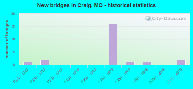
- New bridges - historical statistics
- 11920-1929
- 21930-1939
- 161970-1979
- 11980-1989
- 11990-1999
- 22010-2019


- Bridge Condition - Deck
- 16.7%Very good
- 25.0%Good
- 16.7%Satisfactory
- 33.3%Fair
- 8.3%Poor

- Bridge Condition - Superstructure
- 25.0%Very good
- 41.7%Good
- 8.3%Satisfactory
- 16.7%Fair
- 8.3%Poor

- Bridge Condition - Substructure
- 16.7%Very good
- 16.7%Good
- 50.0%Satisfactory
- 8.3%Fair
- 8.3%Poor

- Bridge Condition - Channel
- 77.8%Satisfactory
- 22.2%Fair
Find on map >> Show street view
Structure Number: 1332, Location: S 30 T 63 N R 39 W (Lat: 40.233911, Lng: -95.347639), Route carried "on" structure: County highway 35, Year Built: 1993, Status: Open, Structure Length: 4.94m (16.21ft), Average Daily Traffic: 20 (year 2021), Truck Traffic: 10%, Average Future Daily Traffic: 23 (year 2041), Design Load: HS 20, Features Intersected: LIT TARKIO CR, Facility Carried by Structure: COUNTY RD 120
Minimum Vertical Clearance: 30+ m (98+ ft), Kilometerpoint: 0.483, Lanes on structure: 2, Owner: County Highway Agency, Approaching Roadway Width: 6.7m (22.0ft), Material/Design: Prestressed concrete, Design/Construction: Stringer/Multi-beam, Number Of Spans In Main Unit: 3, Length of Maximum Span: 16.5m (54.1ft), Curb or Sidewalk Widths: Left: 0.2m (0.7ft), Right: 0.2m (0.7ft), Curb-To-Curb Width: 7.3m (24.0ft), Out-to-Out Width: 8.1m (26.6ft)
Condition: Deck: Good, Superstructure: Very good, Substructure: Very good, Channel: Satisfactory, Operating Rating: 81.0 metric tons, Method Used To Determine Operating Rating: Allowable Stress (AS), Inventory Rating: 40.5 metric tons, Method Used To Determine Inventory Rating: Allowable Stress (AS), Structural Evaluation: Equal to present desirable criteria, Deck Geometry: Equal to present minimum criteria, Waterway Adequacy: Equal to present desirable criteria, Approach Roadway Alignment: Equal to present desirable criteria, Designated Inspection Frequency: Every 24 months, Inspection Date: November 2021, Deck Structure Type: Concrete Cast-file-Place, Wearing Surface/Protective System: Wearing Surface: Monolithic Concrete
Find on map >> Show street view
Structure Number: 1599, Location: S 12 T 62 N R 40 W (Lat: 40.193942, Lng: -95.360481), Route carried "on" structure: Interstate 29, Year Built: 1972, Year Reconstructed: 2021, Status: Open, Structure Length: 4.72m (15.49ft), Average Daily Traffic: 7,908 (year 2021), Truck Traffic: 36%, Average Future Daily Traffic: 16,607 (year 2041), Design Load: HS 20+Mod, Features Intersected: US 59
Minimum Vertical Clearance: 30+ m (98+ ft), Kilometerpoint: 155.971, Lanes on structure: 2, Lanes under structure: 2, Base Highway Network: Yes, Owner: State Highway Agency, Approaching Roadway Width: 11.6m (38.1ft), Skew: 3 degrees, Material/Design: Steel continuous, Design/Construction: Stringer/Multi-beam, Number Of Spans In Main Unit: 3, Length of Maximum Span: 19.8m (65.0ft), Curb-To-Curb Width: 12.0m (39.4ft), Out-to-Out Width: 12.9m (42.3ft)
Condition: Deck: Fair, Superstructure: Satisfactory, Substructure: Satisfactory, Operating Rating: 43.2 metric tons, Method Used To Determine Operating Rating: Load Factor (LF), Inventory Rating: 26.1 metric tons, Method Used To Determine Inventory Rating: Load Factor (LF), Structural Evaluation: Equal to present minimum criteria, Deck Geometry: Equal to present minimum criteria, Underclear: Equal to present minimum criteria, Approach Roadway Alignment: Equal to present desirable criteria, Designated Inspection Frequency: Every 24 months, Inspection Date: November 2021, Deck Structure Type: Concrete Cast-file-Place, Wearing Surface/Protective System: Wearing Surface: Bituminous
Find on map >> Show street view
Structure Number: 16, Location: S 18 T 62 N R 39 W (Lat: 40.186847, Lng: -95.342372), Route carried "on" structure: County highway , Year Built: 1972, Status: Open, Structure Length: 7.59m (24.90ft), Average Daily Traffic: 60 (year 2021), Truck Traffic: 10%, Average Future Daily Traffic: 78 (year 2041), Design Load: H 15, Features Intersected: IS 29, Facility Carried by Structure: ELMWOOD RD S
Minimum Vertical Clearance: 30+ m (98+ ft), Kilometerpoint: 0.903, Lanes on structure: 2, Lanes under structure: 4, Owner: State Highway Agency, Approaching Roadway Width: 6.1m (20.0ft), Skew: 1 degrees, Material/Design: Steel continuous, Design/Construction: Stringer/Multi-beam, Number Of Spans In Main Unit: 2, Number Of Approach Spans: 2, Length of Maximum Span: 27.1m (88.9ft), Curb-To-Curb Width: 8.5m (27.9ft), Out-to-Out Width: 9.4m (30.8ft)
Condition: Deck: Good, Superstructure: Very good, Substructure: Good, Operating Rating: 34.2 metric tons, Method Used To Determine Operating Rating: Allowable Stress (AS), Inventory Rating: 21.6 metric tons, Method Used To Determine Inventory Rating: Allowable Stress (AS), Structural Evaluation: Equal to present minimum criteria, Deck Geometry: Better than present minimum criteria, Underclear: Equal to present minimum criteria, Approach Roadway Alignment: Better than present minimum criteria, Designated Inspection Frequency: Every 24 months, Other Special Inspection Frequency: Every 24 months, Inspection Date: Febuary 2021, Other Special Inspection Date: Febuary 2021, Deck Structure Type: Concrete Cast-file-Place, Wearing Surface/Protective System: Wearing Surface: Monolithic Concrete
Find on map >> Show street view
Structure Number: 1601, Location: S 17 T 62 N R 39 W (Lat: 40.184506, Lng: -95.331294), Route carried "on" structure: Interstate 29, Year Built: 1972, Status: Open, Structure Length: 10.85m (35.60ft), Average Daily Traffic: 7,837 (year 2021), Truck Traffic: 34%, Average Future Daily Traffic: 16,458 (year 2041), Design Load: HS 20+Mod, Features Intersected: LIT TARKIO CR
Minimum Vertical Clearance: 30+ m (98+ ft), Kilometerpoint: 53.905, Lanes on structure: 2, Base Highway Network: Yes, Owner: State Highway Agency, Approaching Roadway Width: 11.6m (38.1ft), Skew: 4 degrees, Material/Design: Steel continuous, Design/Construction: Stringer/Multi-beam, Number Of Spans In Main Unit: 3, Length of Maximum Span: 42.1m (138.1ft), Curb-To-Curb Width: 12.0m (39.4ft), Out-to-Out Width: 12.9m (42.3ft)
Condition: Deck: Satisfactory, Superstructure: Good, Substructure: Good, Channel: Satisfactory, Operating Rating: 53.1 metric tons, Method Used To Determine Operating Rating: Load Factor (LF), Inventory Rating: 26.1 metric tons, Method Used To Determine Inventory Rating: Load Factor (LF), Structural Evaluation: Equal to present minimum criteria, Deck Geometry: Equal to present minimum criteria, Waterway Adequacy: Equal to present desirable criteria, Approach Roadway Alignment: Equal to present desirable criteria, Designated Inspection Frequency: Every 24 months, Inspection Date: Febuary 2021, Deck Structure Type: Concrete Cast-file-Place, Wearing Surface/Protective System: Wearing Surface: Bituminous
Find on map >> Show street view
Structure Number: 1602, Location: S 17 T 62 N R 39 W (Lat: 40.184758, Lng: -95.331389), Route carried "on" structure: Interstate 29, Year Built: 1972, Status: Open, Structure Length: 10.85m (35.60ft), Average Daily Traffic: 7,908 (year 2021), Truck Traffic: 36%, Average Future Daily Traffic: 16,607 (year 2041), Design Load: HS 20+Mod, Features Intersected: LIT TARKIO CR
Minimum Vertical Clearance: 30+ m (98+ ft), Kilometerpoint: 153.179, Lanes on structure: 2, Base Highway Network: Yes, Owner: State Highway Agency, Approaching Roadway Width: 11.6m (38.1ft), Skew: 4 degrees, Material/Design: Steel continuous, Design/Construction: Stringer/Multi-beam, Number Of Spans In Main Unit: 3, Length of Maximum Span: 42.1m (138.1ft), Curb-To-Curb Width: 12.0m (39.4ft), Out-to-Out Width: 12.9m (42.3ft)
Condition: Deck: Poor, Superstructure: Good, Substructure: Satisfactory, Channel: Satisfactory, Operating Rating: 53.1 metric tons, Method Used To Determine Operating Rating: Load Factor (LF), Inventory Rating: 26.1 metric tons, Method Used To Determine Inventory Rating: Load Factor (LF), Structural Evaluation: Equal to present minimum criteria, Deck Geometry: Equal to present minimum criteria, Waterway Adequacy: Equal to present desirable criteria, Approach Roadway Alignment: Equal to present desirable criteria, Designated Inspection Frequency: Every 24 months, Inspection Date: Febuary 2021, Deck Structure Type: Concrete Cast-file-Place, Wearing Surface/Protective System: Wearing Surface: Bituminous
Find on map >> Show street view
Structure Number: 1603, Location: S 16 T 62 N R 39 W (Lat: 40.179622, Lng: -95.313322), Route carried "on" structure: County highway , Year Built: 1972, Status: Open, Structure Length: 8.14m (26.71ft), Average Daily Traffic: 14 (year 2021), Truck Traffic: 10%, Average Future Daily Traffic: 18 (year 2041), Design Load: H 15, Features Intersected: IS 29, Facility Carried by Structure: GRAYSTONE RD S
Minimum Vertical Clearance: 30+ m (98+ ft), Kilometerpoint: 0.119, Lanes on structure: 2, Lanes under structure: 4, Owner: State Highway Agency, Approaching Roadway Width: 6.1m (20.0ft), Material/Design: Steel continuous, Design/Construction: Stringer/Multi-beam, Number Of Spans In Main Unit: 2, Number Of Approach Spans: 2, Length of Maximum Span: 29.5m (96.8ft), Curb-To-Curb Width: 8.5m (27.9ft), Out-to-Out Width: 9.4m (30.8ft)
Condition: Deck: Good, Superstructure: Good, Substructure: Satisfactory, Operating Rating: 33.3 metric tons, Method Used To Determine Operating Rating: Allowable Stress (AS), Inventory Rating: 20.7 metric tons, Method Used To Determine Inventory Rating: Allowable Stress (AS), Structural Evaluation: Equal to present minimum criteria, Deck Geometry: Better than present minimum criteria, Underclear: Equal to present minimum criteria, Approach Roadway Alignment: Equal to present minimum criteria, Designated Inspection Frequency: Every 24 months, Other Special Inspection Frequency: Every 24 months, Inspection Date: Febuary 2021, Other Special Inspection Date: Febuary 2021, Deck Structure Type: Concrete Cast-file-Place, Wearing Surface/Protective System: Wearing Surface: Monolithic Concrete
Find on map >> Show street view
Structure Number: 17149, Location: S 31 T 63 N R 39 W (Lat: 40.219222, Lng: -95.347236), Route carried "on" structure: County highway 144, Year Built: 1981, Status: Posted for load, Structure Length: 3.72m (12.20ft), Average Daily Traffic: 20 (year 2021), Truck Traffic: 10%, Average Future Daily Traffic: 23 (year 2041), Features Intersected: LIT TARKIO CR, Facility Carried by Structure: COUNTY RD 130
Minimum Vertical Clearance: 30+ m (98+ ft), Kilometerpoint: 0.322, Lanes on structure: 2, Owner: County Highway Agency, Approaching Roadway Width: 5.5m (18.0ft), Material/Design: Steel, Design/Construction: Stringer/Multi-beam, Number Of Spans In Main Unit: 1, Number Of Approach Spans: 3, Length of Maximum Span: 21.7m (71.2ft), Curb-To-Curb Width: 7.4m (24.3ft), Out-to-Out Width: 7.4m (24.3ft)
Condition: Deck: Satisfactory, Superstructure: Good, Substructure: Satisfactory, Channel: Satisfactory, Operating Rating: 24.3 metric tons, Method Used To Determine Operating Rating: Allowable Stress (AS), Inventory Rating: 13.5 metric tons, Method Used To Determine Inventory Rating: Allowable Stress (AS), Structural Evaluation: Meets minimum limits, Deck Geometry: Equal to present minimum criteria, Waterway Adequacy: Equal to present minimum criteria, Approach Roadway Alignment: Equal to present minimum criteria, Bridge Posting: Required (Relationship of Operating Rating to Maximum Legal Load: 0.1 - 9.9% below), Designated Inspection Frequency: Every 24 months, Inspection Date: November 2021, Deck Structure Type: Concrete Cast-file-Place, Wearing Surface/Protective System: Wearing Surface: Monolithic Concrete
Find on map >> Show street view
Structure Number: 17189, Location: S 5 T 62 N R 39 W (Lat: 40.212036, Lng: -95.332797), Route carried "on" structure: County highway 145, Year Built: 1920, Status: Posted for load, Structure Length: 1.52m (4.99ft), Average Daily Traffic: 10 (year 2021), Truck Traffic: 10%, Average Future Daily Traffic: 12 (year 2041), Features Intersected: BR OF LIT TARKIO C, Facility Carried by Structure: FARMERS DR
Minimum Vertical Clearance: 30+ m (98+ ft), Kilometerpoint: 0.966, Lanes on structure: 1, Owner: County Highway Agency, Approaching Roadway Width: 4.9m (16.1ft), Material/Design: Steel, Design/Construction: Truss - Thru, Number Of Spans In Main Unit: 1, Length of Maximum Span: 14.9m (48.9ft), Curb-To-Curb Width: 4.8m (15.7ft), Out-to-Out Width: 4.9m (16.1ft)
Condition: Deck: Fair, Superstructure: Fair, Substructure: Fair, Channel: Fair, Operating Rating: 7.2 metric tons, Method Used To Determine Operating Rating: Allowable Stress (AS), Inventory Rating: 4.5 metric tons, Method Used To Determine Inventory Rating: Allowable Stress (AS), Structural Evaluation: High priority of replacement, Deck Geometry: Equal to present desirable criteria, Waterway Adequacy: Equal to present desirable criteria, Approach Roadway Alignment: High priority of corrective action, Bridge Posting: Required (Relationship of Operating Rating to Maximum Legal Load: > 39.9% below), Length Of Structure Improvement: 0.22m (0.72ft), Designated Inspection Frequency: Every 24 months, Critical Feature Inspection Frequency: Every 24 months, Inspection Date: November 2021, Critical Feature Inspection Date: January 2022, Bridge Improvement Cost: $160,000, Roadway Improvement Cost: $16,000, Total Project Cost: $240,000 ( Estimate for 2022), Deck Structure Type: Wood or Timber
Find on map >> Show street view
Structure Number: 2358, Location: S 33 T 63 N R 40 W (Lat: 40.229378, Lng: -95.408272), Route carried "on" structure: County highway , Year Built: 1973, Status: Open, Structure Length: 7.32m (24.02ft), Average Daily Traffic: 60 (year 2021), Truck Traffic: 10%, Average Future Daily Traffic: 78 (year 2041), Design Load: H 15, Features Intersected: IS 29, Facility Carried by Structure: BEAGLE RD S
Minimum Vertical Clearance: 30+ m (98+ ft), Kilometerpoint: 0.085, Lanes on structure: 2, Lanes under structure: 4, Owner: State Highway Agency, Approaching Roadway Width: 6.1m (20.0ft), Material/Design: Steel continuous, Design/Construction: Stringer/Multi-beam, Number Of Spans In Main Unit: 2, Number Of Approach Spans: 2, Length of Maximum Span: 26.2m (86.0ft), Curb-To-Curb Width: 8.5m (27.9ft), Out-to-Out Width: 9.4m (30.8ft)
Condition: Deck: Very good, Superstructure: Good, Substructure: Satisfactory, Operating Rating: 32.4 metric tons, Method Used To Determine Operating Rating: Load Factor (LF), Inventory Rating: 18.9 metric tons, Method Used To Determine Inventory Rating: Load Factor (LF), Structural Evaluation: Somewhat better than minimum adequacy, Deck Geometry: Better than present minimum criteria, Underclear: Somewhat better than minimum adequacy, Approach Roadway Alignment: Equal to present minimum criteria, Designated Inspection Frequency: Every 24 months, Other Special Inspection Frequency: Every 24 months, Inspection Date: Febuary 2021, Other Special Inspection Date: Febuary 2021, Deck Structure Type: Concrete Cast-file-Place, Wearing Surface/Protective System: Wearing Surface: Monolithic Concrete
Find on map >> Show street view
Structure Number: 33616, Location: S 7 T 62 N R 39 W (Lat: 40.195603, Lng: -95.340156), Route carried "on" structure: US 59, Year Built: 2011, Status: Open, Structure Length: 7.28m (23.88ft), Average Daily Traffic: 955 (year 2021), Truck Traffic: 8%, Average Future Daily Traffic: 1,242 (year 2041), Design Load: HS 20, Features Intersected: LITTLE TARKIO CR
Minimum Vertical Clearance: 30+ m (98+ ft), Kilometerpoint: 48.506, Lanes on structure: 2, Owner: State Highway Agency, Approaching Roadway Width: 7.3m (24.0ft), Skew: 2 degrees, Material/Design: Prestressed concrete, Design/Construction: Box Beam or Girders - Multiple, Number Of Spans In Main Unit: 3, Length of Maximum Span: 24.4m (80.1ft), Curb-To-Curb Width: 7.3m (24.0ft), Out-to-Out Width: 7.9m (25.9ft)
Condition: Deck: Fair, Superstructure: Fair, Substructure: Satisfactory, Channel: Satisfactory, Operating Rating: 69.3 metric tons, Method Used To Determine Operating Rating: Load Factor (LF), Inventory Rating: 39.6 metric tons, Method Used To Determine Inventory Rating: Load Factor (LF), Structural Evaluation: Somewhat better than minimum adequacy, Deck Geometry: Meets minimum limits, Waterway Adequacy: Superior to present desirable criteria, Approach Roadway Alignment: Equal to present desirable criteria, Designated Inspection Frequency: Every 24 months, Inspection Date: November 2021, Deck Structure Type: Concrete Precast Panels, Wearing Surface/Protective System: Wearing Surface: Bituminous
Find on map >> Show street view
Structure Number: 33745, Location: S 23 T 62 N R 40 W (Lat: 40.163125, Lng: -95.371469), Route carried "on" structure: State highway 111, Year Built: 2011, Status: Open, Structure Length: 2.59m (8.50ft), Average Daily Traffic: 453 (year 2021), Truck Traffic: 18%, Average Future Daily Traffic: 589 (year 2041), Design Load: HS 20, Features Intersected: OLD CHNL BIG TARKI
Minimum Vertical Clearance: 30+ m (98+ ft), Kilometerpoint: 36.101, Lanes on structure: 2, Owner: State Highway Agency, Approaching Roadway Width: 7.3m (24.0ft), Skew: 3 degrees, Material/Design: Prestressed concrete, Design/Construction: Box Beam or Girders - Multiple, Number Of Spans In Main Unit: 1, Length of Maximum Span: 25.9m (85.0ft), Curb-To-Curb Width: 7.3m (24.0ft), Out-to-Out Width: 7.9m (25.9ft)
Condition: Deck: Very good, Superstructure: Very good, Substructure: Very good, Channel: Satisfactory, Operating Rating: 70.2 metric tons, Method Used To Determine Operating Rating: Load Factor (LF), Inventory Rating: 38.7 metric tons, Method Used To Determine Inventory Rating: Load Factor (LF), Structural Evaluation: Equal to present desirable criteria, Deck Geometry: Meets minimum limits, Waterway Adequacy: Superior to present desirable criteria, Approach Roadway Alignment: Equal to present desirable criteria, Designated Inspection Frequency: Every 24 months, Inspection Date: November 2021, Deck Structure Type: Concrete Precast Panels, Wearing Surface/Protective System: Wearing Surface: Bituminous, Deck Protection: Epoxy Coated Reinforcing
Find on map >> Show street view
Structure Number: 8969, Location: S 11 T 62 N R 40 W (Lat: 40.190439, Lng: -95.378211), Route carried "on" structure: State highway 111, Year Built: 1934, Status: Open, Structure Length: 0.76m (2.49ft), Average Daily Traffic: 92 (year 2021), Truck Traffic: 47%, Average Future Daily Traffic: 120 (year 2041), Design Load: H 10, Features Intersected: OLD CHNL BIG TARKI
Minimum Vertical Clearance: 30+ m (98+ ft), Kilometerpoint: 34.757, Lanes on structure: 2, Owner: State Highway Agency, Approaching Roadway Width: 7.3m (24.0ft), Material/Design: Concrete continuous, Design/Construction: Culvert, Number Of Spans In Main Unit: 2, Length of Maximum Span: 3.7m (12.1ft), Curb-To-Curb Width: 8.5m (27.9ft), Out-to-Out Width: 9.1m (29.9ft)
Condition: Channel: Fair, Culverts: Satisfactory, Operating Rating: 38.7 metric tons, Method Used To Determine Operating Rating: Load Factor (LF), Inventory Rating: 23.4 metric tons, Method Used To Determine Inventory Rating: Load Factor (LF), Structural Evaluation: Equal to present minimum criteria, Deck Geometry: Better than present minimum criteria, Waterway Adequacy: Equal to present desirable criteria, Approach Roadway Alignment: Equal to present minimum criteria, Designated Inspection Frequency: Every 24 months, Inspection Date: January 2022
Find on map >> Show street view
Structure Number: 8992, Location: S 9 T 62 N R 40 W (Lat: 40.190225, Lng: -95.423669), Route carried "on" structure: State highway 111, Year Built: 1934, Status: Posted for load, Structure Length: 5.49m (18.01ft), Average Daily Traffic: 92 (year 2021), Truck Traffic: 47%, Average Future Daily Traffic: 120 (year 2041), Design Load: H 10, Features Intersected: TARKIO RVR
Minimum Vertical Clearance: 30+ m (98+ ft), Kilometerpoint: 30.861, Lanes on structure: 2, Owner: State Highway Agency, Approaching Roadway Width: 6.1m (20.0ft), Material/Design: Steel, Design/Construction: Truss - Thru, Number Of Spans In Main Unit: 1, Number Of Approach Spans: 2, Length of Maximum Span: 30.7m (100.7ft), Curb-To-Curb Width: 6.1m (20.0ft), Out-to-Out Width: 6.5m (21.3ft)
Condition: Deck: Fair, Superstructure: Poor, Substructure: Poor, Channel: Satisfactory, Operating Rating: 18.0 metric tons, Method Used To Determine Operating Rating: Allowable Stress (AS), Inventory Rating: 9.0 metric tons, Method Used To Determine Inventory Rating: Allowable Stress (AS), Structural Evaluation: High priority of replacement, Deck Geometry: Somewhat better than minimum adequacy, Waterway Adequacy: Equal to present minimum criteria, Approach Roadway Alignment: Equal to present minimum criteria, Bridge Posting: Required (Relationship of Operating Rating to Maximum Legal Load: 30.0 - 39.9% below), Length Of Structure Improvement: 0.65m (2.13ft), Designated Inspection Frequency: Every 24 months, Critical Feature Inspection Frequency: Every 24 months, Inspection Date: January 2021, Critical Feature Inspection Date: January 2021, Bridge Improvement Cost: $664,000, Roadway Improvement Cost: $66,000, Total Project Cost: $997,000 ( Estimate for 2022), Deck Structure Type: Concrete Cast-file-Place, Wearing Surface/Protective System: Wearing Surface: Bituminous
Find on map >> Show street view
Structure Number: 1596, Location: S 2 T 62 N R 40 W (Lat: 40.207653, Lng: -95.374433), Route carried "under" structure: Interstate 29, Year Built: 1972, Structure Length: 0. m, Average Daily Traffic: 6,348 (year 2021), Truck Traffic: 34%, Features Intersected: IS 29, Facility Carried by Structure: US 59 S
Minimum Vertical Clearance: 5.21m (17.09ft), Kilometerpoint: 49.240, Lanes on structure: 2, Lanes under structure: 2, Material/Design: Steel continuous, Design/Construction: Stringer/Multi-beam, Length of Maximum Span: 30.1m (98.8ft)
Find on map >> Show street view
Structure Number: 1596, Location: S 2 T 62 N R 40 W (Lat: 40.207653, Lng: -95.374433), Route carried "under" structure: Interstate 29, Year Built: 1972, Structure Length: 0. m, Average Daily Traffic: 6,872 (year 2021), Truck Traffic: 36%, Features Intersected: IS 29, Facility Carried by Structure: US 59 S
Minimum Vertical Clearance: 5.31m (17.42ft), Kilometerpoint: 157.930, Lanes on structure: 2, Lanes under structure: 2, Material/Design: Steel continuous, Design/Construction: Stringer/Multi-beam, Length of Maximum Span: 30.1m (98.8ft)
Find on map >> Show street view
Structure Number: 1598, Location: S 12 T 62 N R 40 W (Lat: 40.193892, Lng: -95.360919), Route carried "under" structure: US 59, Year Built: 1972, Structure Length: 0. m, Average Daily Traffic: 1,068 (year 2021), Truck Traffic: 18%, Features Intersected: US 59, Facility Carried by Structure: IS 29 S
Minimum Vertical Clearance: 4.95m (16.24ft), Kilometerpoint: 46.734, Lanes on structure: 2, Lanes under structure: 2, Material/Design: Steel continuous, Design/Construction: Stringer/Multi-beam, Length of Maximum Span: 19.8m (65.0ft)
Find on map >> Show street view
Structure Number: 1599, Location: S 12 T 62 N R 40 W (Lat: 40.193942, Lng: -95.360481), Route carried "under" structure: US 59, Year Built: 1972, Structure Length: 0. m, Average Daily Traffic: 786 (year 2021), Truck Traffic: 8%, Features Intersected: US 59, Facility Carried by Structure: IS 29 N
Minimum Vertical Clearance: 4.75m (15.58ft), Kilometerpoint: 46.774, Lanes on structure: 2, Lanes under structure: 2, Material/Design: Steel continuous, Design/Construction: Stringer/Multi-beam, Length of Maximum Span: 19.8m (65.0ft)
Find on map >> Show street view
Structure Number: 16, Location: S 18 T 62 N R 39 W (Lat: 40.186847, Lng: -95.342372), Route carried "under" structure: Interstate 29, Year Built: 1972, Structure Length: 0. m, Average Daily Traffic: 7,908 (year 2021), Truck Traffic: 36%, Features Intersected: IS 29, Facility Carried by Structure: ELMWOOD RD S
Minimum Vertical Clearance: 5.06m (16.60ft), Kilometerpoint: 154.203, Lanes on structure: 2, Lanes under structure: 2, Material/Design: Steel continuous, Design/Construction: Stringer/Multi-beam, Length of Maximum Span: 27.1m (88.9ft)
Find on map >> Show street view
Structure Number: 16, Location: S 18 T 62 N R 39 W (Lat: 40.186847, Lng: -95.342372), Route carried "under" structure: Interstate 29, Year Built: 1972, Structure Length: 0. m, Average Daily Traffic: 7,837 (year 2021), Truck Traffic: 34%, Features Intersected: IS 29, Facility Carried by Structure: ELMWOOD RD S
Minimum Vertical Clearance: 5.08m (16.67ft), Kilometerpoint: 52.986, Lanes on structure: 2, Lanes under structure: 2, Material/Design: Steel continuous, Design/Construction: Stringer/Multi-beam, Length of Maximum Span: 27.1m (88.9ft)
Find on map >> Show street view
Structure Number: 1603, Location: S 16 T 62 N R 39 W (Lat: 40.179622, Lng: -95.313322), Route carried "under" structure: Interstate 29, Year Built: 1972, Structure Length: 0. m, Average Daily Traffic: 7,837 (year 2021), Truck Traffic: 34%, Features Intersected: IS 29, Facility Carried by Structure: GRAYSTONE RD S
Minimum Vertical Clearance: 5.56m (18.24ft), Kilometerpoint: 55.595, Lanes on structure: 2, Lanes under structure: 2, Material/Design: Steel continuous, Design/Construction: Stringer/Multi-beam, Length of Maximum Span: 29.5m (96.8ft)
Find on map >> Show street view
Structure Number: 1603, Location: S 16 T 62 N R 39 W (Lat: 40.179622, Lng: -95.313322), Route carried "under" structure: Interstate 29, Year Built: 1972, Structure Length: 0. m, Average Daily Traffic: 7,908 (year 2021), Truck Traffic: 36%, Features Intersected: IS 29, Facility Carried by Structure: GRAYSTONE RD S
Minimum Vertical Clearance: 5.08m (16.67ft), Kilometerpoint: 151.578, Lanes on structure: 2, Lanes under structure: 2, Material/Design: Steel continuous, Design/Construction: Stringer/Multi-beam, Length of Maximum Span: 29.5m (96.8ft)
Find on map >> Show street view
Structure Number: 2358, Location: S 33 T 63 N R 40 W (Lat: 40.229378, Lng: -95.408272), Route carried "under" structure: Interstate 29, Year Built: 1973, Structure Length: 0. m, Average Daily Traffic: 6,348 (year 2021), Truck Traffic: 34%, Features Intersected: IS 29, Facility Carried by Structure: BEAGLE RD S
Minimum Vertical Clearance: 4.93m (16.17ft), Kilometerpoint: 45.458, Lanes on structure: 2, Lanes under structure: 2, Material/Design: Steel continuous, Design/Construction: Stringer/Multi-beam, Length of Maximum Span: 26.2m (86.0ft)
Find on map >> Show street view
Structure Number: 2358, Location: S 33 T 63 N R 40 W (Lat: 40.229378, Lng: -95.408272), Route carried "under" structure: Interstate 29, Year Built: 1973, Structure Length: 0. m, Average Daily Traffic: 6,872 (year 2021), Truck Traffic: 36%, Features Intersected: IS 29, Facility Carried by Structure: BEAGLE RD S
Minimum Vertical Clearance: 4.90m (16.08ft), Kilometerpoint: 161.712, Lanes on structure: 2, Lanes under structure: 2, Material/Design: Steel continuous, Design/Construction: Stringer/Multi-beam, Length of Maximum Span: 26.2m (86.0ft)