Bridge Statistics for Creola, Alabama (AL)
Condition, Traffic, Stress, Structural Evaluation, Project Costs
- National Bridge Inventory (NBI) Statistics
- 34Number of bridges
- 6,923ft / 2,110mTotal length
- $665,757,000Total costs
- 370,092Total average daily traffic
- 71,712Total average daily truck traffic
- National Bridge Inventory (NBI) Registered Bridges for Creola
- No street view available for this location
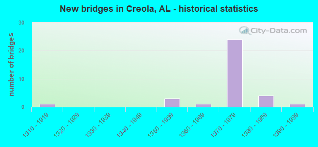
- New bridges - historical statistics
- 11910-1919
- 31950-1959
- 11960-1969
- 241970-1979
- 41980-1989
- 11990-1999

- Reconstructed bridges - Historical Statistics
- 11970-1979
- 11980-1989


- Bridge Condition - Deck
- 5.6%Good
- 50.0%Satisfactory
- 44.4%Fair

- Bridge Condition - Superstructure
- 11.1%Good
- 55.6%Satisfactory
- 33.3%Fair

- Bridge Condition - Substructure
- 22.2%Good
- 55.6%Satisfactory
- 22.2%Fair

- Bridge Condition - Channel
- 37.5%Good
- 50.0%Satisfactory
- 12.5%Fair

- Bridge Condition - Culverts
- 14.3%Good
- 57.1%Satisfactory
- 28.6%Fair
Find on map >> Show street view
Structure Number: 102, Location: OVERBROOK RD * SHADES CK (Lat: 33.486864, Lng: -86.752550), Route carried "on" structure: City street 83, Year Built: 1915, Status: Open, Structure Length: 1.37m (4.49ft), Average Daily Traffic: 2,730 (year 2016), Truck Traffic: 1%, Average Future Daily Traffic: 3,900 (year 2036), Design Load: HS 15, Features Intersected: SHADES CREEK, Facility Carried by Structure: OVERBROOK RD
Minimum Vertical Clearance: 30+ m (98+ ft), Kilometerpoint: 0.200, Lanes on structure: 2, Owner: City or Municipal Highway Agency, Approaching Roadway Width: 6.4m (21.0ft), Material/Design: Concrete, Design/Construction: Arch - Deck, Number Of Spans In Main Unit: 2, Length of Maximum Span: 8.8m (28.9ft), Curb or Sidewalk Widths: Left: 1.2m (3.9ft), Right: 1.2m (3.9ft), Curb-To-Curb Width: 6.8m (22.3ft), Out-to-Out Width: 10.2m (33.5ft)
Condition: Deck: Satisfactory, Superstructure: Satisfactory, Substructure: Satisfactory, Channel: Fair, Operating Rating: 43.5 metric tons, Method Used To Determine Operating Rating: Field evaluation and documented engineering judgment, Inventory Rating: 32.7 metric tons, Method Used To Determine Inventory Rating: Field evaluation and documented engineering judgment, Structural Evaluation: Equal to present minimum criteria, Deck Geometry: High priority of replacement, Waterway Adequacy: Equal to present minimum criteria, Approach Roadway Alignment: Equal to present minimum criteria, Length Of Structure Improvement: 2.05m (6.73ft), Designated Inspection Frequency: Every 24 months, Inspection Date: April 2020, Bridge Improvement Cost: $463,000, Roadway Improvement Cost: $46,000, Total Project Cost: $509,000 ( Estimate for 2022)
Find on map >> Show street view
Structure Number: 5854, Location: 0.6 MI N JCT I-65 (Lat: 30.882350, Lng: -88.041867), Route carried "on" structure: US 43, Year Built: 1957, Status: Open, Structure Length: 9.33m (30.61ft), Average Daily Traffic: 13,653 (year 2018), Truck Traffic: 11%, Average Future Daily Traffic: 20,480 (year 2038), Design Load: H 20, Features Intersected: GUNNISON CREEK
Minimum Vertical Clearance: 30+ m (98+ ft), Kilometerpoint: 17.642, Lanes on structure: 2, Base Highway Network: Yes, Owner: State Highway Agency, Approaching Roadway Width: 8.5m (27.9ft), Skew: 10 degrees, Material/Design: Concrete, Design/Construction: Tee Beam, Number Of Spans In Main Unit: 9, Length of Maximum Span: 10.4m (34.1ft), Curb-To-Curb Width: 8.5m (27.9ft), Out-to-Out Width: 10.2m (33.5ft)
Condition: Deck: Fair, Superstructure: Fair, Substructure: Fair, Channel: Satisfactory, Operating Rating: 37.6 metric tons, Method Used To Determine Operating Rating: Load Factor (LF), Inventory Rating: 22.6 metric tons, Method Used To Determine Inventory Rating: Load Factor (LF), Structural Evaluation: Somewhat better than minimum adequacy, Deck Geometry: Meets minimum limits, Waterway Adequacy: Equal to present minimum criteria, Approach Roadway Alignment: Better than present minimum criteria, Length Of Structure Improvement: 10.28m (33.73ft), Designated Inspection Frequency: Every 24 months, Underwater Inspection Frequency: Every 24 months, Inspection Date: July 2020, Underwater Inspection Date: December 2020, Bridge Improvement Cost: $2,327,000, Roadway Improvement Cost: $233,000, Total Project Cost: $2,560,000 ( Estimate for 2022), Deck Structure Type: Concrete Cast-file-Place
Find on map >> Show street view
Structure Number: 5855, Location: 0.6 MI N JCT I-65 (Lat: 30.882333, Lng: -88.041731), Route carried "on" structure: US 43, Year Built: 1957, Status: Open, Structure Length: 9.33m (30.61ft), Average Daily Traffic: 13,653 (year 2018), Truck Traffic: 11%, Average Future Daily Traffic: 20,480 (year 2038), Design Load: H 20, Features Intersected: GUNNISON CREEK
Minimum Vertical Clearance: 30+ m (98+ ft), Kilometerpoint: 17.642, Lanes on structure: 2, Base Highway Network: Yes, Owner: State Highway Agency, Approaching Roadway Width: 8.5m (27.9ft), Skew: 10 degrees, Material/Design: Concrete, Design/Construction: Tee Beam, Number Of Spans In Main Unit: 9, Length of Maximum Span: 10.4m (34.1ft), Curb-To-Curb Width: 8.5m (27.9ft), Out-to-Out Width: 10.2m (33.5ft)
Condition: Deck: Fair, Superstructure: Fair, Substructure: Fair, Channel: Satisfactory, Operating Rating: 37.6 metric tons, Method Used To Determine Operating Rating: Load Factor (LF), Inventory Rating: 22.6 metric tons, Method Used To Determine Inventory Rating: Load Factor (LF), Structural Evaluation: Somewhat better than minimum adequacy, Deck Geometry: Meets minimum limits, Waterway Adequacy: Better than present minimum criteria, Approach Roadway Alignment: Equal to present minimum criteria, Length Of Structure Improvement: 10.28m (33.73ft), Designated Inspection Frequency: Every 24 months, Underwater Inspection Frequency: Every 24 months, Other Special Inspection Frequency: Every 12 months, Inspection Date: July 2020, Underwater Inspection Date: December 2020, Other Special Inspection Date: July 2021, Bridge Improvement Cost: $2,327,000, Roadway Improvement Cost: $233,000, Total Project Cost: $2,560,000 ( Estimate for 2022), Deck Structure Type: Concrete Cast-file-Place
Find on map >> Show street view
Structure Number: 8066, Location: 2.5 MI NE US 43 (Lat: 30.905000, Lng: -88.005000), Route carried "on" structure: City street , Year Built: 1963, Status: Open, Structure Length: 0.64m (2.10ft), Average Daily Traffic: 1,882 (year 2019), Truck Traffic: 1%, Average Future Daily Traffic: 2,543 (year 2039), Design Load: H 20, Features Intersected: JIM BELL BRANCH, Facility Carried by Structure: CREOLA-AXIS LOOP
Minimum Vertical Clearance: 30+ m (98+ ft), Kilometerpoint: 2.540, Lanes on structure: 2, Owner: City or Municipal Highway Agency, Approaching Roadway Width: 6.7m (22.0ft), Material/Design: Concrete, Design/Construction: Culvert, Number Of Spans In Main Unit: 2, Length of Maximum Span: 3.0m (9.8ft)
Condition: Channel: Satisfactory, Culverts: Satisfactory, Operating Rating: 48.7 metric tons, Method Used To Determine Operating Rating: Load Factor (LF), Inventory Rating: 29.2 metric tons, Method Used To Determine Inventory Rating: Load Factor (LF), Structural Evaluation: Equal to present minimum criteria, Waterway Adequacy: Better than present minimum criteria, Approach Roadway Alignment: Equal to present minimum criteria, Length Of Structure Improvement: 1.26m (4.13ft), Designated Inspection Frequency: Every 24 months, Inspection Date: May 2021, Bridge Improvement Cost: $306,000, Roadway Improvement Cost: $31,000, Total Project Cost: $337,000 ( Estimate for 2022)
Find on map >> Show street view
Structure Number: 10195, Location: 1.1 MI S US 43 (Lat: 30.868167, Lng: -88.059822), Route carried "on" structure: Interstate 65, Year Built: 1970, Status: Open, Structure Length: 7.92m (25.98ft), Average Daily Traffic: 22,126 (year 2018), Truck Traffic: 16%, Average Future Daily Traffic: 33,189 (year 2038), Design Load: HS 20, Features Intersected: Alabama Gulf Coast RR
Minimum Vertical Clearance: 30+ m (98+ ft), Kilometerpoint: 29.604, Lanes on structure: 2, Base Highway Network: Yes, Owner: State Highway Agency, Approaching Roadway Width: 12.2m (40.0ft), Skew: 14 degrees, Material/Design: Steel continuous, Design/Construction: Stringer/Multi-beam, Number Of Spans In Main Unit: 3, Length of Maximum Span: 30.5m (100.1ft), Curb-To-Curb Width: 12.0m (39.4ft), Out-to-Out Width: 13.1m (43.0ft)
Condition: Deck: Fair, Superstructure: Good, Substructure: Satisfactory, Operating Rating: 57.0 metric tons, Method Used To Determine Operating Rating: Load Factor (LF), Inventory Rating: 34.1 metric tons, Method Used To Determine Inventory Rating: Load Factor (LF), Structural Evaluation: Equal to present minimum criteria, Deck Geometry: Equal to present minimum criteria, Underclear: Better than present minimum criteria, Approach Roadway Alignment: Equal to present desirable criteria, Length Of Structure Improvement: 8.94m (29.33ft), Designated Inspection Frequency: Every 24 months, Inspection Date: June 2020, Bridge Improvement Cost: $2,634,000, Roadway Improvement Cost: $263,000, Total Project Cost: $2,897,000 ( Estimate for 2022), Deck Structure Type: Concrete Cast-file-Place
Find on map >> Show street view
Structure Number: 10196, Location: 1.1 MI S US 43 (Lat: 30.867858, Lng: -88.059889), Route carried "on" structure: Interstate 65, Year Built: 1970, Status: Open, Structure Length: 7.92m (25.98ft), Average Daily Traffic: 22,126 (year 2018), Truck Traffic: 16%, Average Future Daily Traffic: 33,189 (year 2038), Design Load: HS 20, Features Intersected: Alabama Gulf Coast RR
Minimum Vertical Clearance: 30+ m (98+ ft), Kilometerpoint: 29.604, Lanes on structure: 2, Base Highway Network: Yes, Owner: State Highway Agency, Approaching Roadway Width: 13.4m (44.0ft), Skew: 14 degrees, Material/Design: Steel continuous, Design/Construction: Stringer/Multi-beam, Number Of Spans In Main Unit: 3, Length of Maximum Span: 30.5m (100.1ft), Curb-To-Curb Width: 12.0m (39.4ft), Out-to-Out Width: 13.1m (43.0ft)
Condition: Deck: Fair, Superstructure: Satisfactory, Substructure: Good, Operating Rating: 57.0 metric tons, Method Used To Determine Operating Rating: Load Factor (LF), Inventory Rating: 34.1 metric tons, Method Used To Determine Inventory Rating: Load Factor (LF), Structural Evaluation: Equal to present minimum criteria, Deck Geometry: Equal to present minimum criteria, Underclear: Better than present minimum criteria, Approach Roadway Alignment: Equal to present desirable criteria, Length Of Structure Improvement: 8.94m (29.33ft), Designated Inspection Frequency: Every 24 months, Inspection Date: June 2020, Bridge Improvement Cost: $2,634,000, Roadway Improvement Cost: $263,000, Total Project Cost: $2,897,000 ( Estimate for 2022), Deck Structure Type: Concrete Cast-file-Place
Find on map >> Show street view
Structure Number: 10197, Location: SATSUMA/CREOLA CITY LIMIT (Lat: 30.876986, Lng: -88.045119), Route carried "on" structure: Interstate 65, Year Built: 1970, Status: Open, Structure Length: 13.56m (44.49ft), Average Daily Traffic: 12,347 (year 2018), Truck Traffic: 24%, Average Future Daily Traffic: 18,521 (year 2038), Design Load: HS 20, Features Intersected: US 43
Minimum Vertical Clearance: 30+ m (98+ ft), Kilometerpoint: 31.326, Lanes on structure: 3, Lanes under structure: 6, Base Highway Network: Yes, Owner: State Highway Agency, Approaching Roadway Width: 11.9m (39.0ft), Skew: 14 degrees, Material/Design: Steel continuous, Design/Construction: Stringer/Multi-beam, Number Of Spans In Main Unit: 4, Length of Maximum Span: 40.5m (132.9ft), Curb-To-Curb Width: 15.6m (51.2ft), Out-to-Out Width: 16.7m (54.8ft)
Condition: Deck: Fair, Superstructure: Satisfactory, Substructure: Satisfactory, Operating Rating: 58.0 metric tons, Method Used To Determine Operating Rating: Load Factor (LF), Inventory Rating: 34.7 metric tons, Method Used To Determine Inventory Rating: Load Factor (LF), Structural Evaluation: Equal to present minimum criteria, Deck Geometry: Somewhat better than minimum adequacy, Underclear: Superior to present desirable criteria, Approach Roadway Alignment: Equal to present desirable criteria, Length Of Structure Improvement: 14.37m (47.15ft), Designated Inspection Frequency: Every 24 months, Inspection Date: June 2020, Bridge Improvement Cost: $5,322,000, Roadway Improvement Cost: $532,000, Total Project Cost: $5,854,000 ( Estimate for 2022), Deck Structure Type: Concrete Cast-file-Place
Find on map >> Show street view
Structure Number: 10198, Location: SATSUMA/CREOLA CITY LIMIT (Lat: 30.876686, Lng: -88.045147), Route carried "on" structure: Interstate 65, Year Built: 1970, Status: Open, Structure Length: 13.56m (44.49ft), Average Daily Traffic: 12,347 (year 2018), Truck Traffic: 24%, Average Future Daily Traffic: 18,521 (year 2038), Design Load: HS 20, Features Intersected: US 43
Minimum Vertical Clearance: 30+ m (98+ ft), Kilometerpoint: 31.326, Lanes on structure: 2, Lanes under structure: 6, Base Highway Network: Yes, Owner: State Highway Agency, Approaching Roadway Width: 11.9m (39.0ft), Skew: 14 degrees, Material/Design: Steel continuous, Design/Construction: Stringer/Multi-beam, Number Of Spans In Main Unit: 4, Length of Maximum Span: 40.5m (132.9ft), Curb-To-Curb Width: 12.0m (39.4ft), Out-to-Out Width: 13.1m (43.0ft)
Condition: Deck: Satisfactory, Superstructure: Satisfactory, Substructure: Satisfactory, Operating Rating: 58.9 metric tons, Method Used To Determine Operating Rating: Load Factor (LF), Inventory Rating: 35.3 metric tons, Method Used To Determine Inventory Rating: Load Factor (LF), Structural Evaluation: Equal to present minimum criteria, Deck Geometry: Equal to present minimum criteria, Underclear: Superior to present desirable criteria, Approach Roadway Alignment: Equal to present desirable criteria, Length Of Structure Improvement: 14.37m (47.15ft), Designated Inspection Frequency: Every 24 months, Inspection Date: June 2020, Bridge Improvement Cost: $4,238,000, Roadway Improvement Cost: $424,000, Total Project Cost: $4,662,000 ( Estimate for 2022), Deck Structure Type: Concrete Cast-file-Place
Find on map >> Show street view
Structure Number: 10199, Location: SATSUMA/CREOLA CITY LIMIT (Lat: 30.875486, Lng: -88.044847), Route carried "on" structure: Interstate 65, Year Built: 1970, Status: Open, Structure Length: 10.61m (34.81ft), Average Daily Traffic: 4,054 (year 2018), Truck Traffic: 6%, Average Future Daily Traffic: 6,081 (year 2038), Design Load: HS 20, Features Intersected: US 43
Minimum Vertical Clearance: 30+ m (98+ ft), Kilometerpoint: 31.260, Lanes on structure: 2, Lanes under structure: 4, Owner: State Highway Agency, Approaching Roadway Width: 12.2m (40.0ft), Skew: 4 degrees, Material/Design: Steel continuous, Design/Construction: Stringer/Multi-beam, Number Of Spans In Main Unit: 4, Length of Maximum Span: 31.4m (103.0ft), Curb-To-Curb Width: 12.0m (39.4ft), Out-to-Out Width: 13.1m (43.0ft)
Condition: Deck: Satisfactory, Superstructure: Satisfactory, Substructure: Satisfactory, Operating Rating: 49.2 metric tons, Method Used To Determine Operating Rating: Load Factor (LF), Inventory Rating: 29.5 metric tons, Method Used To Determine Inventory Rating: Load Factor (LF), Structural Evaluation: Equal to present minimum criteria, Deck Geometry: Equal to present minimum criteria, Underclear: Better than present minimum criteria, Approach Roadway Alignment: Equal to present desirable criteria, Length Of Structure Improvement: 11.51m (37.76ft), Designated Inspection Frequency: Every 24 months, Inspection Date: June 2020, Bridge Improvement Cost: $3,394,000, Roadway Improvement Cost: $339,000, Total Project Cost: $3,733,000 ( Estimate for 2022), Deck Structure Type: Concrete Cast-file-Place
Find on map >> Show street view
Structure Number: 102, Location: 0.2 MI N E US 43 (Lat: 30.878417, Lng: -88.042767), Route carried "on" structure: Interstate 65, Year Built: 1970, Status: Open, Structure Length: 10.36m (33.99ft), Average Daily Traffic: 12,472 (year 2019), Truck Traffic: 26%, Average Future Daily Traffic: 18,708 (year 2039), Design Load: HS 20, Features Intersected: RAMP 2 * NORF SO RR
Minimum Vertical Clearance: 30+ m (98+ ft), Kilometerpoint: 31.574, Lanes on structure: 2, Lanes under structure: 2, Base Highway Network: Yes, Owner: State Highway Agency, Approaching Roadway Width: 11.9m (39.0ft), Skew: 14 degrees, Material/Design: Steel continuous, Design/Construction: Stringer/Multi-beam, Number Of Spans In Main Unit: 4, Length of Maximum Span: 31.4m (103.0ft), Curb-To-Curb Width: 11.9m (39.0ft), Out-to-Out Width: 13.1m (43.0ft)
Condition: Deck: Fair, Superstructure: Satisfactory, Substructure: Satisfactory, Operating Rating: 52.7 metric tons, Method Used To Determine Operating Rating: Load Factor (LF), Inventory Rating: 31.6 metric tons, Method Used To Determine Inventory Rating: Load Factor (LF), Structural Evaluation: Equal to present minimum criteria, Deck Geometry: Equal to present minimum criteria, Underclear: Superior to present desirable criteria, Approach Roadway Alignment: Equal to present desirable criteria, Length Of Structure Improvement: 11.28m (37.01ft), Designated Inspection Frequency: Every 24 months, Inspection Date: Febuary 2021, Bridge Improvement Cost: $3,326,000, Roadway Improvement Cost: $333,000, Total Project Cost: $3,659,000 ( Estimate for 2022), Deck Structure Type: Concrete Cast-file-Place
Find on map >> Show street view
Structure Number: 10201, Location: 0.2 MI N E US 43 (Lat: 30.878069, Lng: -88.042858), Route carried "on" structure: Interstate 65, Year Built: 1970, Status: Open, Structure Length: 10.36m (33.99ft), Average Daily Traffic: 12,472 (year 2019), Truck Traffic: 26%, Average Future Daily Traffic: 18,708 (year 2039), Design Load: HS 20, Features Intersected: RAMP 2 * NORFOLK SO RR
Minimum Vertical Clearance: 30+ m (98+ ft), Kilometerpoint: 31.574, Lanes on structure: 3, Lanes under structure: 2, Base Highway Network: Yes, Owner: State Highway Agency, Approaching Roadway Width: 11.9m (39.0ft), Skew: 14 degrees, Material/Design: Steel continuous, Design/Construction: Stringer/Multi-beam, Number Of Spans In Main Unit: 4, Length of Maximum Span: 31.4m (103.0ft), Curb-To-Curb Width: 15.6m (51.2ft), Out-to-Out Width: 16.7m (54.8ft)
Condition: Deck: Satisfactory, Superstructure: Good, Substructure: Satisfactory, Operating Rating: 59.6 metric tons, Method Used To Determine Operating Rating: Load Factor (LF), Inventory Rating: 35.7 metric tons, Method Used To Determine Inventory Rating: Load Factor (LF), Structural Evaluation: Equal to present minimum criteria, Deck Geometry: Somewhat better than minimum adequacy, Underclear: Better than present minimum criteria, Approach Roadway Alignment: Equal to present desirable criteria, Length Of Structure Improvement: 11.28m (37.01ft), Designated Inspection Frequency: Every 24 months, Inspection Date: Febuary 2021, Bridge Improvement Cost: $4,176,000, Roadway Improvement Cost: $418,000, Total Project Cost: $4,594,000 ( Estimate for 2022), Deck Structure Type: Concrete Cast-file-Place
Find on map >> Show street view
Structure Number: 10202, Location: 0.4 MI N E US 43 (Lat: 30.880117, Lng: -88.039917), Route carried "on" structure: Interstate 65, Year Built: 1970, Status: Open, Structure Length: 13.49m (44.26ft), Average Daily Traffic: 12,347 (year 2018), Truck Traffic: 24%, Average Future Daily Traffic: 18,520 (year 2038), Design Load: HS 20, Features Intersected: GUNNISON CREEK
Minimum Vertical Clearance: 30+ m (98+ ft), Kilometerpoint: 31.944, Lanes on structure: 2, Base Highway Network: Yes, Owner: State Highway Agency, Approaching Roadway Width: 11.9m (39.0ft), Skew: 10 degrees, Material/Design: Steel, Design/Construction: Stringer/Multi-beam, Number Of Spans In Main Unit: 7, Length of Maximum Span: 24.4m (80.1ft), Curb-To-Curb Width: 11.9m (39.0ft), Out-to-Out Width: 13.1m (43.0ft)
Condition: Deck: Fair, Superstructure: Satisfactory, Substructure: Satisfactory, Channel: Good, Operating Rating: 51.4 metric tons, Method Used To Determine Operating Rating: Load Factor (LF), Inventory Rating: 30.8 metric tons, Method Used To Determine Inventory Rating: Load Factor (LF), Structural Evaluation: Equal to present minimum criteria, Deck Geometry: Equal to present minimum criteria, Waterway Adequacy: Equal to present minimum criteria, Approach Roadway Alignment: Equal to present desirable criteria, Length Of Structure Improvement: 14.30m (46.92ft), Designated Inspection Frequency: Every 24 months, Underwater Inspection Frequency: Every 24 months, Inspection Date: June 2020, Underwater Inspection Date: August 2020, Bridge Improvement Cost: $4,215,000, Roadway Improvement Cost: $422,000, Total Project Cost: $4,637,000 ( Estimate for 2022), Deck Structure Type: Concrete Cast-file-Place
Find on map >> Show street view
Structure Number: 10203, Location: 0.4 MI N E US 43 (Lat: 30.879872, Lng: -88.039817), Route carried "on" structure: Interstate 65, Year Built: 1970, Status: Open, Structure Length: 13.49m (44.26ft), Average Daily Traffic: 12,347 (year 2018), Truck Traffic: 24%, Average Future Daily Traffic: 18,520 (year 2038), Design Load: HS 20, Features Intersected: GUNNISON CREEK
Minimum Vertical Clearance: 30+ m (98+ ft), Kilometerpoint: 31.944, Lanes on structure: 2, Base Highway Network: Yes, Owner: State Highway Agency, Approaching Roadway Width: 11.9m (39.0ft), Skew: 10 degrees, Material/Design: Steel, Design/Construction: Stringer/Multi-beam, Number Of Spans In Main Unit: 7, Length of Maximum Span: 24.4m (80.1ft), Curb-To-Curb Width: 11.9m (39.0ft), Out-to-Out Width: 13.1m (43.0ft)
Condition: Deck: Satisfactory, Superstructure: Satisfactory, Substructure: Good, Channel: Good, Operating Rating: 51.4 metric tons, Method Used To Determine Operating Rating: Load Factor (LF), Inventory Rating: 30.8 metric tons, Method Used To Determine Inventory Rating: Load Factor (LF), Structural Evaluation: Equal to present minimum criteria, Deck Geometry: Equal to present minimum criteria, Waterway Adequacy: Equal to present minimum criteria, Approach Roadway Alignment: Equal to present desirable criteria, Length Of Structure Improvement: 14.30m (46.92ft), Designated Inspection Frequency: Every 24 months, Underwater Inspection Frequency: Every 24 months, Inspection Date: June 2020, Underwater Inspection Date: August 2020, Bridge Improvement Cost: $4,215,000, Roadway Improvement Cost: $422,000, Total Project Cost: $4,637,000 ( Estimate for 2022), Deck Structure Type: Concrete Cast-file-Place
Find on map >> Show street view
Structure Number: 10204, Location: 0.8 MI N E US 43 (Lat: 30.883431, Lng: -88.034969), Route carried "on" structure: City street , Year Built: 1970, Status: Open, Structure Length: 9.02m (29.59ft), Average Daily Traffic: 1,204 (year 2018), Truck Traffic: 1%, Average Future Daily Traffic: 1,806 (year 2038), Design Load: HS 20, Features Intersected: I-65, Facility Carried by Structure: LISTER DAIRY RD
Minimum Vertical Clearance: 30+ m (98+ ft), Kilometerpoint: 0.000, Lanes on structure: 2, Lanes under structure: 4, Owner: State Highway Agency, Approaching Roadway Width: 7.5m (24.6ft), Material/Design: Concrete continuous, Design/Construction: Tee Beam, Number Of Spans In Main Unit: 4, Length of Maximum Span: 25.0m (82.0ft), Curb-To-Curb Width: 8.5m (27.9ft), Out-to-Out Width: 9.7m (31.8ft)
Condition: Deck: Satisfactory, Superstructure: Satisfactory, Substructure: Good, Operating Rating: 42.4 metric tons, Method Used To Determine Operating Rating: Load Factor (LF), Inventory Rating: 25.4 metric tons, Method Used To Determine Inventory Rating: Load Factor (LF), Structural Evaluation: Equal to present minimum criteria, Deck Geometry: Somewhat better than minimum adequacy, Underclear: Somewhat better than minimum adequacy, Approach Roadway Alignment: Better than present minimum criteria, Length Of Structure Improvement: 9.99m (32.78ft), Designated Inspection Frequency: Every 24 months, Inspection Date: May 2020, Bridge Improvement Cost: $2,124,000, Roadway Improvement Cost: $212,000, Total Project Cost: $2,336,000 ( Estimate for 2022), Deck Structure Type: Concrete Cast-file-Place
Find on map >> Show street view
Structure Number: 1041, Location: 850' S I65 (Lat: 30.881056, Lng: -88.033047), Route carried "on" structure: City street , Year Built: 1970, Status: Open, Structure Length: 0.73m (2.40ft), Average Daily Traffic: 682 (year 2019), Truck Traffic: 1%, Average Future Daily Traffic: 899 (year 2039), Design Load: H 20, Features Intersected: HARPER'S BRANCH, Facility Carried by Structure: LISTER DAIRY ROAD
Minimum Vertical Clearance: 30+ m (98+ ft), Kilometerpoint: 0.950, Lanes on structure: 2, Owner: City or Municipal Highway Agency, Approaching Roadway Width: 11.6m (38.1ft), Skew: 4 degrees, Material/Design: Concrete, Design/Construction: Culvert, Number Of Spans In Main Unit: 2, Length of Maximum Span: 3.4m (11.2ft)
Condition: Channel: Satisfactory, Culverts: Good, Operating Rating: 53.8 metric tons, Method Used To Determine Operating Rating: Load Factor (LF), Inventory Rating: 32.2 metric tons, Method Used To Determine Inventory Rating: Load Factor (LF), Structural Evaluation: Better than present minimum criteria, Waterway Adequacy: Somewhat better than minimum adequacy, Approach Roadway Alignment: Equal to present minimum criteria, Length Of Structure Improvement: 1.38m (4.53ft), Designated Inspection Frequency: Every 24 months, Inspection Date: May 2021, Bridge Improvement Cost: $676,000, Roadway Improvement Cost: $68,000, Total Project Cost: $744,000 ( Estimate for 2022)
Find on map >> Show street view
Structure Number: 10411, Location: 0.5 MI W US 43 (Lat: 30.896667, Lng: -88.046667), Route carried "on" structure: City street , Year Built: 1970, Status: Open, Structure Length: 3.66m (12.01ft), Average Daily Traffic: 2,278 (year 2019), Truck Traffic: 18%, Average Future Daily Traffic: 3,074 (year 2039), Design Load: H 20, Features Intersected: GUNNISON CREEK, Facility Carried by Structure: RADCLIFF ROAD
Minimum Vertical Clearance: 30+ m (98+ ft), Kilometerpoint: 4.699, Lanes on structure: 2, Owner: City or Municipal Highway Agency, Approaching Roadway Width: 8.5m (27.9ft), Material/Design: Concrete, Design/Construction: Channel Beam, Number Of Spans In Main Unit: 5, Length of Maximum Span: 7.3m (24.0ft), Curb-To-Curb Width: 8.8m (28.9ft), Out-to-Out Width: 9.8m (32.2ft)
Condition: Deck: Satisfactory, Superstructure: Fair, Substructure: Satisfactory, Channel: Good, Operating Rating: 44.5 metric tons, Method Used To Determine Operating Rating: Load Factor (LF), Inventory Rating: 26.7 metric tons, Method Used To Determine Inventory Rating: Load Factor (LF), Structural Evaluation: Somewhat better than minimum adequacy, Deck Geometry: Meets minimum limits, Waterway Adequacy: Better than present minimum criteria, Approach Roadway Alignment: Equal to present desirable criteria, Length Of Structure Improvement: 4.58m (15.03ft), Designated Inspection Frequency: Every 24 months, Underwater Inspection Frequency: Every 48 months, Inspection Date: May 2021, Underwater Inspection Date: May 2021, Bridge Improvement Cost: $1,005,000, Roadway Improvement Cost: $101,000, Total Project Cost: $1,106,000 ( Estimate for 2022), Deck Structure Type: Concrete Precast Panels, Wearing Surface/Protective System: Wearing Surface: Bituminous
Find on map >> Show street view
Structure Number: 10412, Location: 0.3 MI W US 43 (Lat: 30.896667, Lng: -88.043333), Route carried "on" structure: City street , Year Built: 1970, Status: Open, Structure Length: 3.66m (12.01ft), Average Daily Traffic: 2,009 (year 2019), Truck Traffic: 18%, Average Future Daily Traffic: 2,712 (year 2039), Design Load: H 20, Features Intersected: SEYMORE CREEK, Facility Carried by Structure: RADCLIFF ROAD
Minimum Vertical Clearance: 30+ m (98+ ft), Kilometerpoint: 4.939, Lanes on structure: 2, Owner: City or Municipal Highway Agency, Approaching Roadway Width: 8.5m (27.9ft), Material/Design: Concrete, Design/Construction: Channel Beam, Number Of Spans In Main Unit: 5, Length of Maximum Span: 7.3m (24.0ft), Curb-To-Curb Width: 8.8m (28.9ft), Out-to-Out Width: 9.8m (32.2ft)
Condition: Deck: Satisfactory, Superstructure: Fair, Substructure: Satisfactory, Channel: Good, Operating Rating: 44.5 metric tons, Method Used To Determine Operating Rating: Load Factor (LF), Inventory Rating: 26.7 metric tons, Method Used To Determine Inventory Rating: Load Factor (LF), Structural Evaluation: Somewhat better than minimum adequacy, Deck Geometry: Meets minimum limits, Waterway Adequacy: Equal to present desirable criteria, Approach Roadway Alignment: Equal to present desirable criteria, Length Of Structure Improvement: 4.58m (15.03ft), Designated Inspection Frequency: Every 24 months, Underwater Inspection Frequency: Every 48 months, Inspection Date: May 2021, Underwater Inspection Date: May 2021, Bridge Improvement Cost: $1,005,000, Roadway Improvement Cost: $101,000, Total Project Cost: $1,106,000 ( Estimate for 2022), Deck Structure Type: Concrete Precast Panels, Wearing Surface/Protective System: Wearing Surface: Bituminous
Find on map >> Show street view
Structure Number: 11351, Location: 1.3 MI N E US 43 (Lat: 30.885972, Lng: -88.029667), Route carried "on" structure: Interstate 65, Year Built: 1975, Status: Open, Structure Length: 1.07m (3.51ft), Average Daily Traffic: 24,693 (year 2018), Truck Traffic: 28%, Average Future Daily Traffic: 37,039 (year 2038), Design Load: HS 20, Features Intersected: HARPERS BRANCH
Minimum Vertical Clearance: 30+ m (98+ ft), Kilometerpoint: 33.104, Lanes on structure: 4, Base Highway Network: Yes, Owner: State Highway Agency, Approaching Roadway Width: 23.8m (78.1ft), Skew: 14 degrees, Material/Design: Concrete, Design/Construction: Culvert, Number Of Spans In Main Unit: 2, Length of Maximum Span: 3.7m (12.1ft)
Condition: Channel: Good, Culverts: Fair, Operating Rating: 88.9 metric tons, Method Used To Determine Operating Rating: Load Factor (LF), Inventory Rating: 54.4 metric tons, Method Used To Determine Inventory Rating: Load Factor (LF), Structural Evaluation: Somewhat better than minimum adequacy, Waterway Adequacy: Equal to present minimum criteria, Approach Roadway Alignment: Equal to present desirable criteria, Length Of Structure Improvement: 1.74m (5.71ft), Designated Inspection Frequency: Every 24 months, Inspection Date: May 2020, Bridge Improvement Cost: $2,289,000, Roadway Improvement Cost: $229,000, Total Project Cost: $2,518,000 ( Estimate for 2022)
Find on map >> Show street view
Structure Number: 11352, Location: 2.5 MI N E US 43 (Lat: 30.895717, Lng: -88.014042), Route carried "on" structure: Interstate 65, Year Built: 1975, Status: Open, Structure Length: 1.52m (4.99ft), Average Daily Traffic: 24,693 (year 2018), Truck Traffic: 28%, Average Future Daily Traffic: 37,039 (year 2038), Design Load: HS 20, Features Intersected: STREAM TO DEAD LAKE
Minimum Vertical Clearance: 30+ m (98+ ft), Kilometerpoint: 34.942, Lanes on structure: 4, Base Highway Network: Yes, Owner: State Highway Agency, Approaching Roadway Width: 23.8m (78.1ft), Skew: 15 degrees, Material/Design: Concrete, Design/Construction: Culvert, Number Of Spans In Main Unit: 3, Length of Maximum Span: 2.7m (8.9ft)
Condition: Channel: Satisfactory, Culverts: Fair, Operating Rating: 88.9 metric tons, Method Used To Determine Operating Rating: Load Factor (LF), Inventory Rating: 54.4 metric tons, Method Used To Determine Inventory Rating: Load Factor (LF), Structural Evaluation: Somewhat better than minimum adequacy, Waterway Adequacy: Equal to present minimum criteria, Approach Roadway Alignment: Equal to present desirable criteria, Length Of Structure Improvement: 2.20m (7.22ft), Designated Inspection Frequency: Every 24 months, Inspection Date: May 2020, Bridge Improvement Cost: $3,921,000, Roadway Improvement Cost: $392,000, Total Project Cost: $4,313,000 ( Estimate for 2022)
Find on map >> Show street view
Structure Number: 11494, Location: 915' N SAILOR'S RD (Lat: 30.895000, Lng: -88.013333), Route carried "on" structure: City street , Year Built: 1975, Status: Open, Structure Length: 1.22m (4.00ft), Average Daily Traffic: 315 (year 2019), Truck Traffic: 1%, Average Future Daily Traffic: 415 (year 2039), Design Load: H 20, Features Intersected: BRANCH, Facility Carried by Structure: I65 SERV. RD EAST
Minimum Vertical Clearance: 30+ m (98+ ft), Kilometerpoint: 1.500, Lanes on structure: 2, Owner: City or Municipal Highway Agency, Approaching Roadway Width: 11.0m (36.1ft), Skew: 4 degrees, Material/Design: Concrete, Design/Construction: Culvert, Number Of Spans In Main Unit: 3, Length of Maximum Span: 4.0m (13.1ft)
Condition: Channel: Fair, Culverts: Satisfactory, Operating Rating: 63.7 metric tons, Method Used To Determine Operating Rating: Load Factor (LF), Inventory Rating: 38.1 metric tons, Method Used To Determine Inventory Rating: Load Factor (LF), Structural Evaluation: Equal to present minimum criteria, Waterway Adequacy: Somewhat better than minimum adequacy, Approach Roadway Alignment: Equal to present minimum criteria, Length Of Structure Improvement: 1.89m (6.20ft), Designated Inspection Frequency: Every 24 months, Inspection Date: May 2021, Bridge Improvement Cost: $546,000, Roadway Improvement Cost: $55,000, Total Project Cost: $601,000 ( Estimate for 2022)
Find on map >> Show street view
Structure Number: 11544, Location: 0.8 MI S I65 (Lat: 30.893333, Lng: -88.013333), Route carried "on" structure: City street , Year Built: 1957, Year Reconstructed: 1976, Status: Open, Structure Length: 0.64m (2.10ft), Average Daily Traffic: 604 (year 2019), Truck Traffic: 1%, Average Future Daily Traffic: 796 (year 2039), Design Load: HS 20, Features Intersected: SWAMP, Facility Carried by Structure: LISTER DAIRY ROAD
Minimum Vertical Clearance: 30+ m (98+ ft), Kilometerpoint: 0.349, Lanes on structure: 2, Owner: City or Municipal Highway Agency, Approaching Roadway Width: 10.4m (34.1ft), Material/Design: Concrete, Design/Construction: Culvert, Number Of Spans In Main Unit: 2, Length of Maximum Span: 3.0m (9.8ft)
Condition: Channel: Good, Culverts: Satisfactory, Operating Rating: 49.4 metric tons, Method Used To Determine Operating Rating: Load Factor (LF), Inventory Rating: 29.6 metric tons, Method Used To Determine Inventory Rating: Load Factor (LF), Structural Evaluation: Equal to present minimum criteria, Waterway Adequacy: Somewhat better than minimum adequacy, Approach Roadway Alignment: Equal to present minimum criteria, Length Of Structure Improvement: 1.26m (4.13ft), Designated Inspection Frequency: Every 24 months, Inspection Date: May 2021, Bridge Improvement Cost: $255,000, Roadway Improvement Cost: $26,000, Total Project Cost: $281,000 ( Estimate for 2022)
Find on map >> Show street view
Structure Number: 11576, Location: 2.3 MI N E US 43 (Lat: 30.894133, Lng: -88.017219), Route carried "on" structure: City street , Year Built: 1976, Year Reconstructed: 1994, Status: Open, Structure Length: 9.14m (29.99ft), Average Daily Traffic: 1,467 (year 2018), Truck Traffic: 3%, Average Future Daily Traffic: 2,200 (year 2038), Design Load: HS 20, Features Intersected: I-65, Facility Carried by Structure: SAILOR'S RD
Minimum Vertical Clearance: 30+ m (98+ ft), Kilometerpoint: 0.000, Lanes on structure: 2, Lanes under structure: 6, Owner: State Highway Agency, Approaching Roadway Width: 16.2m (53.1ft), Material/Design: Concrete continuous, Design/Construction: Tee Beam, Number Of Spans In Main Unit: 4, Length of Maximum Span: 25.0m (82.0ft), Curb-To-Curb Width: 13.4m (44.0ft), Out-to-Out Width: 14.3m (46.9ft)
Condition: Deck: Good, Superstructure: Satisfactory, Substructure: Good, Operating Rating: 45.4 metric tons, Method Used To Determine Operating Rating: Load Factor (LF), Inventory Rating: 27.2 metric tons, Method Used To Determine Inventory Rating: Load Factor (LF), Structural Evaluation: Equal to present minimum criteria, Deck Geometry: Equal to present desirable criteria, Underclear: Equal to present minimum criteria, Approach Roadway Alignment: Equal to present desirable criteria, Length Of Structure Improvement: 10.11m (33.17ft), Designated Inspection Frequency: Every 24 months, Inspection Date: May 2020, Bridge Improvement Cost: $3,258,000, Roadway Improvement Cost: $326,000, Total Project Cost: $3,584,000 ( Estimate for 2022), Deck Structure Type: Concrete Cast-file-Place
Find on map >> Show street view
Structure Number: 12321, Location: 5.5 MI N E US 43 (Lat: 30.909228, Lng: -87.976006), Route carried "on" structure: Interstate 65, Year Built: 1980, Status: Open, Structure Length: 978.36m (3209.84ft), Average Daily Traffic: 11,672 (year 2018), Truck Traffic: 28%, Average Future Daily Traffic: 17,508 (year 2038), Design Load: HS 20, Features Intersected: MOBILE RIVER DELTA
Minimum Vertical Clearance: 5.72m (18.77ft), Kilometerpoint: 39.122, Lanes on structure: 2, Lanes under structure: 2, Base Highway Network: Yes, Owner: State Highway Agency, Approaching Roadway Width: 11.9m (39.0ft), Skew: 10 degrees, Navigation Control: Yes ( Vertical Clearance: 7.6m (24.9ft), Horizontal Clearance: 30.5m (100.1ft)), Material/Design: Steel, Design/Construction: Arch - Thru, Number Of Spans In Main Unit: 1, Number Of Approach Spans: 342, Length of Maximum Span: 243.8m (799.9ft), Curb-To-Curb Width: 11.9m (39.0ft), Out-to-Out Width: 12.7m (41.7ft)
Condition: Deck: Satisfactory, Superstructure: Fair, Substructure: Fair, Channel: Satisfactory, Operating Rating: 47.4 metric tons, Method Used To Determine Operating Rating: Load Factor (LF), Inventory Rating: 26.9 metric tons, Method Used To Determine Inventory Rating: Load Factor (LF), Structural Evaluation: Somewhat better than minimum adequacy, Deck Geometry: Equal to present minimum criteria, Underclear: Superior to present desirable criteria, Waterway Adequacy: Superior to present desirable criteria, Approach Roadway Alignment: Equal to present desirable criteria, Length Of Structure Improvement: 978.36m (3209.84ft), Designated Inspection Frequency: Every 24 months, Critical Feature Inspection Frequency: Every 24 months, Underwater Inspection Frequency: Every 24 months, Other Special Inspection Frequency: Every 12 months, Inspection Date: July 2020, Critical Feature Inspection Date: July 2021, Underwater Inspection Date: May 2020, Other Special Inspection Date: July 2021, Bridge Improvement Cost: $275,050,000, Roadway Improvement Cost: $27,505,000, Total Project Cost: $302,555,000 ( Estimate for 2022), Deck Structure Type: Concrete Cast-file-Place
Find on map >> Show street view
Structure Number: 12322, Location: 5.5 MI N E US 43 (Lat: 30.908767, Lng: -87.975864), Route carried "on" structure: Interstate 65, Year Built: 1980, Status: Open, Structure Length: 978.58m (3210.56ft), Average Daily Traffic: 11,672 (year 2018), Truck Traffic: 28%, Average Future Daily Traffic: 17,508 (year 2038), Design Load: HS 20, Features Intersected: MOBILE RIVER DELTA
Minimum Vertical Clearance: 5.65m (18.54ft), Kilometerpoint: 39.122, Lanes on structure: 2, Lanes under structure: 2, Base Highway Network: Yes, Owner: State Highway Agency, Approaching Roadway Width: 11.9m (39.0ft), Skew: 10 degrees, Navigation Control: Yes ( Vertical Clearance: 7.6m (24.9ft), Horizontal Clearance: 30.5m (100.1ft)), Material/Design: Steel, Design/Construction: Arch - Thru, Number Of Spans In Main Unit: 1, Number Of Approach Spans: 342, Length of Maximum Span: 243.8m (799.9ft), Curb-To-Curb Width: 11.9m (39.0ft), Out-to-Out Width: 12.7m (41.7ft)
Condition: Deck: Fair, Superstructure: Fair, Substructure: Fair, Channel: Satisfactory, Operating Rating: 47.4 metric tons, Method Used To Determine Operating Rating: Load Factor (LF), Inventory Rating: 26.9 metric tons, Method Used To Determine Inventory Rating: Load Factor (LF), Structural Evaluation: Somewhat better than minimum adequacy, Deck Geometry: Equal to present minimum criteria, Underclear: Superior to present desirable criteria, Waterway Adequacy: Superior to present desirable criteria, Approach Roadway Alignment: Equal to present desirable criteria, Length Of Structure Improvement: 978.58m (3210.56ft), Designated Inspection Frequency: Every 24 months, Critical Feature Inspection Frequency: Every 24 months, Underwater Inspection Frequency: Every 24 months, Inspection Date: June 2020, Critical Feature Inspection Date: June 2020, Underwater Inspection Date: May 2020, Bridge Improvement Cost: $275,115,000, Roadway Improvement Cost: $27,512,000, Total Project Cost: $302,627,000 ( Estimate for 2022), Deck Structure Type: Concrete Cast-file-Place
Find on map >> Show street view
Structure Number: 15369, Location: 0.3 MI N I-65 SERVICE RD (Lat: 30.879483, Lng: -88.048114), Route carried "on" structure: County highway , Year Built: 1991, Status: Open, Structure Length: 0.87m (2.85ft), Average Daily Traffic: 763 (year 2021), Truck Traffic: 5%, Average Future Daily Traffic: 1,404 (year 2040), Design Load: HS 20, Features Intersected: HALL BRANCH, Facility Carried by Structure: HALL BRANCH RD
Minimum Vertical Clearance: 30+ m (98+ ft), Kilometerpoint: 0.010, Lanes on structure: 2, Owner: City or Municipal Highway Agency, Approaching Roadway Width: 6.2m (20.3ft), Material/Design: Concrete, Design/Construction: Culvert, Number Of Spans In Main Unit: 2, Length of Maximum Span: 4.3m (14.1ft)
Condition: Channel: Satisfactory, Culverts: Satisfactory, Operating Rating: 50.1 metric tons, Method Used To Determine Operating Rating: Load Factor (LF), Inventory Rating: 30.0 metric tons, Method Used To Determine Inventory Rating: Load Factor (LF), Structural Evaluation: Equal to present minimum criteria, Waterway Adequacy: Equal to present desirable criteria, Approach Roadway Alignment: Equal to present minimum criteria, Length Of Structure Improvement: 1.54m (5.05ft), Designated Inspection Frequency: Every 24 months, Underwater Inspection Frequency: Every 24 months, Inspection Date: September 2020, Underwater Inspection Date: September 2020, Bridge Improvement Cost: $409,000, Roadway Improvement Cost: $41,000, Total Project Cost: $450,000 ( Estimate for 2022)
Find on map >> Show street view
Structure Number: 10197, Location: SATSUMA/CREOLA CITY LIMIT (Lat: 30.876986, Lng: -88.045119), Route carried "under" structure: US 43, Year Built: 1970, Structure Length: 0. m, Average Daily Traffic: 27,305 (year 2016), Truck Traffic: 11%, Features Intersected: US 43, Facility Carried by Structure: I-65 SB
Minimum Vertical Clearance: 5.67m (18.60ft), Kilometerpoint: 16.676, Lanes on structure: 3, Lanes under structure: 2, Material/Design: Steel continuous, Design/Construction: Stringer/Multi-beam, Length of Maximum Span: 40.5m (132.9ft)
Find on map >> Show street view
Structure Number: 10198, Location: SATSUMA/CREOLA CITY LIMIT (Lat: 30.876686, Lng: -88.045147), Route carried "under" structure: US 43, Year Built: 1970, Structure Length: 0. m, Average Daily Traffic: 27,305 (year 2018), Truck Traffic: 11%, Features Intersected: US 43, Facility Carried by Structure: I-65 NB
Minimum Vertical Clearance: 5.43m (17.81ft), Kilometerpoint: 16.676, Lanes on structure: 2, Lanes under structure: 6, Material/Design: Steel continuous, Design/Construction: Stringer/Multi-beam, Length of Maximum Span: 40.5m (132.9ft)
Find on map >> Show street view
Structure Number: 10199, Location: SATSUMA/CREOLA CITY LIMIT (Lat: 30.875486, Lng: -88.044847), Route carried "under" structure: US 43, Year Built: 1970, Structure Length: 0. m, Average Daily Traffic: 19,142 (year 2018), Truck Traffic: 10%, Features Intersected: US 43, Facility Carried by Structure: I-65 OFF RAMP
Minimum Vertical Clearance: 5.04m (16.54ft), Kilometerpoint: 16.699, Lanes on structure: 2, Lanes under structure: 4, Material/Design: Steel continuous, Design/Construction: Stringer/Multi-beam, Length of Maximum Span: 31.4m (103.0ft)
Find on map >> Show street view
Structure Number: 102, Location: 0.2 MI N E US 43 (Lat: 30.878417, Lng: -88.042767), Route carried "under" structure: Ramp Interstate 65, Year Built: 1970, Structure Length: 0. m, Average Daily Traffic: 4,095 (year 2019), Truck Traffic: 12%, Features Intersected: RAMP 2 * NORF SO RR
Minimum Vertical Clearance: 5.49m (18.01ft), Kilometerpoint: 31.574, Lanes on structure: 2, Lanes under structure: 2, Material/Design: Steel continuous, Design/Construction: Stringer/Multi-beam, Length of Maximum Span: 31.4m (103.0ft)
Find on map >> Show street view
Structure Number: 10201, Location: 0.2 MI N E US 43 (Lat: 30.878069, Lng: -88.042858), Route carried "under" structure: Ramp Interstate 65, Year Built: 1970, Structure Length: 0. m, Average Daily Traffic: 4,095 (year 2019), Truck Traffic: 12%, Features Intersected: RAMP 2 * NORFOLK SO RR
Minimum Vertical Clearance: 5.15m (16.90ft), Kilometerpoint: 31.574, Lanes on structure: 3, Lanes under structure: 2, Material/Design: Steel continuous, Design/Construction: Stringer/Multi-beam, Length of Maximum Span: 31.4m (103.0ft)
Find on map >> Show street view
Structure Number: 10204, Location: 0.8 MI N E US 43 (Lat: 30.883431, Lng: -88.034969), Route carried "under" structure: Interstate 65, Year Built: 1970, Structure Length: 0. m, Average Daily Traffic: 24,693 (year 2018), Truck Traffic: 28%, Features Intersected: I-65, Facility Carried by Structure: LISTER DAIRY RD
Minimum Vertical Clearance: 4.88m (16.01ft), Kilometerpoint: 32.543, Lanes on structure: 2, Lanes under structure: 4, Material/Design: Concrete continuous, Design/Construction: Tee Beam, Length of Maximum Span: 25.0m (82.0ft)
Find on map >> Show street view
Structure Number: 11576, Location: 2.3 MI N E US 43 (Lat: 30.894133, Lng: -88.017219), Route carried "under" structure: Interstate 65, Year Built: 1976, Structure Length: 0. m, Average Daily Traffic: 24,693 (year 2018), Truck Traffic: 24%, Features Intersected: I-65, Facility Carried by Structure: SAILOR'S RD
Minimum Vertical Clearance: 5.20m (17.06ft), Kilometerpoint: 34.598, Lanes on structure: 2, Lanes under structure: 6, Material/Design: Concrete continuous, Design/Construction: Tee Beam, Length of Maximum Span: 25.0m (82.0ft)
Find on map >> Show street view
Structure Number: 12321, Location: 5.5 MI N E US 43 (Lat: 30.909228, Lng: -87.976006), Route carried "under" structure: County highway , Year Built: 1980, Structure Length: 0. m, Average Daily Traffic: 1,078 (year 2018), Truck Traffic: 1%, Features Intersected: MOBILE RIVER DELTA, Facility Carried by Structure: I-65 SB
Minimum Vertical Clearance: 7.30m (23.95ft), Kilometerpoint: 0.000, Lanes on structure: 2, Lanes under structure: 2, Material/Design: Steel, Design/Construction: Arch - Thru, Length of Maximum Span: 243.8m (799.9ft)
Find on map >> Show street view
Structure Number: 12322, Location: 5.5 MI N E US 43 (Lat: 30.908767, Lng: -87.975864), Route carried "under" structure: County highway , Year Built: 1980, Structure Length: 0. m, Average Daily Traffic: 1,078 (year 2018), Truck Traffic: 1%, Features Intersected: MOBILE RIVER DELTA, Facility Carried by Structure: I-65 NB
Minimum Vertical Clearance: 7.64m (25.07ft), Kilometerpoint: 0.000, Lanes on structure: 2, Lanes under structure: 2, Material/Design: Steel, Design/Construction: Arch - Thru, Length of Maximum Span: 243.8m (799.9ft)