Bridge Statistics for Crowder, Mississippi (MS)
Condition, Traffic, Stress, Structural Evaluation, Project Costs
- National Bridge Inventory (NBI) Statistics
- 12Number of bridges
- 125ft / 38.4mTotal length
- $684,506,000Total costs
- 5,655Total average daily traffic
- 541Total average daily truck traffic
- 6,379Total future (year 2035) average daily traffic
- National Bridge Inventory (NBI) Registered Bridges for Crowder
- No street view available for this location
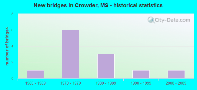
- New bridges - historical statistics
- 11960-1969
- 61970-1979
- 31980-1989
- 11990-1999
- 12000-2009

- Bridge Condition - Deck
- 11.1%Very good
- 22.2%Good
- 33.3%Satisfactory
- 22.2%Fair
- 11.1%Poor

- Bridge Condition - Superstructure
- 33.3%Very good
- 33.3%Satisfactory
- 22.2%Poor
- 11.1%Critical

- Bridge Condition - Substructure
- 11.1%Very good
- 33.3%Good
- 22.2%Fair
- 11.1%Poor
- 22.2%Critical

- Bridge Condition - Channel
- 8.3%Very good
- 41.7%Good
- 41.7%Satisfactory
- 8.3%Fair

- Bridge Condition - Culverts
- 66.7%Good
- 33.3%Satisfactory
Find on map >> Show street view
Structure Number: 31000350682588, Location: 10.8 MI N SR 32 EAST (Lat: 34.156997, Lng: -90.076850), Route carried "on" structure: State highway 35, Year Built: 1964, Status: Open, Structure Length: 1.07m (3.51ft), Average Daily Traffic: 910 (year 2020), Truck Traffic: 9%, Average Future Daily Traffic: 910 (year 2040), Design Load: HS 15, Features Intersected: SHELTON CREEK
Minimum Vertical Clearance: 30+ m (98+ ft), Kilometerpoint: 37.525, Lanes on structure: 2, Base Highway Network: Yes (Inventory Route: 3, Subroute: 2), Owner: State Highway Agency, Approaching Roadway Width: 10.4m (34.1ft), Material/Design: Concrete, Design/Construction: Culvert, Number Of Spans In Main Unit: 2, Length of Maximum Span: 4.9m (16.1ft)
Condition: Channel: Satisfactory, Culverts: Satisfactory, Operating Rating: 40.3 metric tons, Method Used To Determine Operating Rating: Load Factor (LF), Inventory Rating: 24.1 metric tons, Method Used To Determine Inventory Rating: Load Factor (LF), Structural Evaluation: Equal to present minimum criteria, Waterway Adequacy: Equal to present minimum criteria, Approach Roadway Alignment: Equal to present desirable criteria, Designated Inspection Frequency: Every 24 months, Inspection Date: July 2021
Find on map >> Show street view
Structure Number: 31003220540418, Location: 2.0 MI E QUITMAN CL (Lat: 34.179908, Lng: -90.107169), Route carried "on" structure: State highway 322, Year Built: 1970, Status: Open, Structure Length: 4.88m (16.01ft), Average Daily Traffic: 1,100 (year 2020), Truck Traffic: 11%, Average Future Daily Traffic: 1,100 (year 2040), Design Load: HS 15, Features Intersected: RELIEF OPENING
Minimum Vertical Clearance: 30+ m (98+ ft), Kilometerpoint: 2.810, Lanes on structure: 2, Owner: State Highway Agency, Approaching Roadway Width: 7.9m (25.9ft), Material/Design: Steel, Design/Construction: Stringer/Multi-beam, Number Of Spans In Main Unit: 4, Length of Maximum Span: 12.2m (40.0ft), Curb or Sidewalk Widths: Left: 0.2m (0.7ft), Right: 0.2m (0.7ft), Curb-To-Curb Width: 7.9m (25.9ft), Out-to-Out Width: 8.5m (27.9ft)
Condition: Deck: Satisfactory, Superstructure: Satisfactory, Substructure: Good, Channel: Very good, Operating Rating: 44.6 metric tons, Method Used To Determine Operating Rating: Load Factor (LF), Inventory Rating: 26.8 metric tons, Method Used To Determine Inventory Rating: Load Factor (LF), Structural Evaluation: Equal to present minimum criteria, Deck Geometry: Meets minimum limits, Waterway Adequacy: Equal to present desirable criteria, Approach Roadway Alignment: Equal to present desirable criteria, Length Of Structure Improvement: 4.88m (16.01ft), Designated Inspection Frequency: Every 24 months, Inspection Date: August 2021, Bridge Improvement Cost: $160,000,000, Roadway Improvement Cost: $26,000,000, Total Project Cost: $420,000,000, Deck Structure Type: Concrete Cast-file-Place
Find on map >> Show street view
Structure Number: 31003220540419, Location: 2.1 MI E QUITMAN CL (Lat: 34.179542, Lng: -90.105697), Route carried "on" structure: State highway 322, Year Built: 1970, Status: Open, Structure Length: 13.41m (44.00ft), Average Daily Traffic: 1,100 (year 2020), Truck Traffic: 11%, Average Future Daily Traffic: 1,100 (year 2040), Design Load: HS 15, Features Intersected: PANOLA QUITMAN FLOODWAY
Minimum Vertical Clearance: 30+ m (98+ ft), Kilometerpoint: 2.952, Lanes on structure: 2, Owner: State Highway Agency, Approaching Roadway Width: 7.9m (25.9ft), Material/Design: Steel, Design/Construction: Stringer/Multi-beam, Number Of Spans In Main Unit: 2, Number Of Approach Spans: 6, Length of Maximum Span: 24.4m (80.1ft), Curb or Sidewalk Widths: Left: 0.2m (0.7ft), Right: 0.2m (0.7ft), Curb-To-Curb Width: 7.9m (25.9ft), Out-to-Out Width: 8.5m (27.9ft)
Condition: Deck: Satisfactory, Superstructure: Satisfactory, Substructure: Fair, Channel: Good, Operating Rating: 42.0 metric tons, Method Used To Determine Operating Rating: Load Factor (LF), Inventory Rating: 25.1 metric tons, Method Used To Determine Inventory Rating: Load Factor (LF), Structural Evaluation: Somewhat better than minimum adequacy, Deck Geometry: Meets minimum limits, Waterway Adequacy: Equal to present desirable criteria, Approach Roadway Alignment: Equal to present desirable criteria, Length Of Structure Improvement: 13.41m (44.00ft), Designated Inspection Frequency: Every 24 months, Underwater Inspection Frequency: Every 60 months, Inspection Date: August 2021, Underwater Inspection Date: July 2019, Bridge Improvement Cost: $190,000,000, Roadway Improvement Cost: $26,000,000, Total Project Cost: $264,000,000, Deck Structure Type: Concrete Cast-file-Place
Find on map >> Show street view
Structure Number: 31003220540422, Location: 2.4 MI E QUITMAN CL (Lat: 34.178939, Lng: -90.100717), Route carried "on" structure: State highway 322, Year Built: 1970, Status: Open, Structure Length: 1.89m (6.20ft), Average Daily Traffic: 1,100 (year 2020), Truck Traffic: 11%, Average Future Daily Traffic: 1,100 (year 2040), Design Load: HS 20, Features Intersected: STREAM
Minimum Vertical Clearance: 30+ m (98+ ft), Kilometerpoint: 3.421, Lanes on structure: 2, Owner: State Highway Agency, Approaching Roadway Width: 11.6m (38.1ft), Skew: 4 degrees, Material/Design: Concrete, Design/Construction: Culvert, Number Of Spans In Main Unit: 2, Length of Maximum Span: 6.1m (20.0ft)
Condition: Channel: Good, Culverts: Good, Operating Rating: 75.8 metric tons, Method Used To Determine Operating Rating: Load Factor (LF), Inventory Rating: 45.3 metric tons, Method Used To Determine Inventory Rating: Load Factor (LF), Structural Evaluation: Better than present minimum criteria, Waterway Adequacy: Equal to present minimum criteria, Approach Roadway Alignment: Equal to present desirable criteria, Designated Inspection Frequency: Every 48 months, Inspection Date: November 2021
Find on map >> Show street view
Structure Number: SA6000000000032, Location: SEC 10 T26N R 1E (Lat: 34.145944, Lng: -90.187917), Route carried "on" structure: County highway 243, Year Built: 1998, Status: Open, Structure Length: 0.98m (3.22ft), Average Daily Traffic: 120 (year 2015), Truck Traffic: 8%, Average Future Daily Traffic: 180 (year 2035), Design Load: HS 20, Features Intersected: DRAINAGE DITCH, Facility Carried by Structure: TERRY ROAD
Minimum Vertical Clearance: 30+ m (98+ ft), Kilometerpoint: 3.540, Lanes on structure: 2, Owner: County Highway Agency, Approaching Roadway Width: 8.5m (27.9ft), Material/Design: Concrete, Design/Construction: Culvert, Number Of Spans In Main Unit: 2, Length of Maximum Span: 4.9m (16.1ft)
Condition: Channel: Good, Culverts: Good, Operating Rating: 89.4 metric tons, Method Used To Determine Operating Rating: Load Factor (LF) rating reported by rating factor (RF) method using MS18 loading, Inventory Rating: 53.5 metric tons, Method Used To Determine Inventory Rating: Load Factor (LF) rating reported by rating factor (RF) method using MS18 loading, Structural Evaluation: Better than present minimum criteria, Waterway Adequacy: Equal to present desirable criteria, Approach Roadway Alignment: Equal to present desirable criteria, Designated Inspection Frequency: Every 24 months, Inspection Date: July 2021
Find on map >> Show street view
Structure Number: SA6000000000064, Location: SEC 13 T27N R 1E B (Lat: 34.213336, Lng: -90.136275), Route carried "on" structure: County highway 837, Year Built: 2000, Status: Open, Structure Length: 1.74m (5.71ft), Average Daily Traffic: 1,100 (year 2018), Truck Traffic: 8%, Average Future Daily Traffic: 1,650 (year 2038), Design Load: HS 20, Features Intersected: 837 OVER DRAINAGE DITCH, Facility Carried by Structure: DUMMY-LINE ROAD
Minimum Vertical Clearance: 30+ m (98+ ft), Kilometerpoint: 4.506, Lanes on structure: 2, Owner: County Highway Agency, Approaching Roadway Width: 8.5m (27.9ft), Material/Design: Concrete, Design/Construction: Channel Beam, Number Of Spans In Main Unit: 3, Length of Maximum Span: 5.8m (19.0ft), Curb or Sidewalk Widths: Left: 0.5m (1.6ft), Right: 0.5m (1.6ft), Curb-To-Curb Width: 9.8m (32.2ft), Out-to-Out Width: 10.8m (35.4ft)
Condition: Deck: Very good, Superstructure: Very good, Substructure: Very good, Channel: Good, Operating Rating: 70.6 metric tons, Method Used To Determine Operating Rating: Load Factor (LF), Inventory Rating: 42.2 metric tons, Method Used To Determine Inventory Rating: Load Factor (LF), Structural Evaluation: Equal to present desirable criteria, Deck Geometry: Somewhat better than minimum adequacy, Waterway Adequacy: Equal to present desirable criteria, Approach Roadway Alignment: Equal to present desirable criteria, Designated Inspection Frequency: Every 24 months, Inspection Date: August 2021, Deck Structure Type: Concrete Precast Panels, Wearing Surface/Protective System: Wearing Surface: Monolithic Concrete
Find on map >> Show street view
Structure Number: SA6000000000069, Location: SEC 23 T27N R 1E B (Lat: 34.201675, Lng: -90.169242), Route carried "on" structure: County highway 223, Year Built: 1974, Status: Open, Structure Length: 4.88m (16.01ft), Average Daily Traffic: 100 (year 2018), Average Future Daily Traffic: 150 (year 2038), Design Load: HS 15, Features Intersected: OLD LITTLE TALLAHATCHIE, Facility Carried by Structure: BOBO ROAD
Minimum Vertical Clearance: 30+ m (98+ ft), Kilometerpoint: 3.218, Lanes on structure: 2, Owner: County Highway Agency, Approaching Roadway Width: 7.9m (25.9ft), Material/Design: Prestressed concrete, Design/Construction: Stringer/Multi-beam, Number Of Spans In Main Unit: 4, Length of Maximum Span: 12.2m (40.0ft), Curb or Sidewalk Widths: Left: 0.4m (1.3ft), Right: 0.4m (1.3ft), Curb-To-Curb Width: 7.9m (25.9ft), Out-to-Out Width: 8.7m (28.5ft)
Condition: Deck: Good, Superstructure: Very good, Substructure: Good, Channel: Satisfactory, Operating Rating: 60.8 metric tons, Method Used To Determine Operating Rating: Load Factor (LF), Inventory Rating: 27.5 metric tons, Method Used To Determine Inventory Rating: Load Factor (LF), Structural Evaluation: Equal to present minimum criteria, Deck Geometry: Equal to present minimum criteria, Waterway Adequacy: Equal to present desirable criteria, Approach Roadway Alignment: Equal to present minimum criteria, Designated Inspection Frequency: Every 24 months, Inspection Date: August 2021, Deck Structure Type: Concrete Cast-file-Place, Wearing Surface/Protective System: Wearing Surface: Monolithic Concrete
Find on map >> Show street view
Structure Number: SA6000000000071, Location: SEC 27 T27N R 1E B (Lat: 34.185539, Lng: -90.187553), Route carried "on" structure: County highway 223, Year Built: 1974, Status: Open, Structure Length: 6.10m (20.01ft), Average Daily Traffic: 100 (year 2018), Average Future Daily Traffic: 150 (year 2038), Design Load: HS 15, Features Intersected: OLD LITTLE TALLAHATCHIE, Facility Carried by Structure: SUTTON ROAD
Minimum Vertical Clearance: 30+ m (98+ ft), Kilometerpoint: 0.643, Lanes on structure: 2, Owner: County Highway Agency, Approaching Roadway Width: 7.9m (25.9ft), Material/Design: Prestressed concrete, Design/Construction: Stringer/Multi-beam, Number Of Spans In Main Unit: 5, Length of Maximum Span: 12.2m (40.0ft), Curb or Sidewalk Widths: Left: 0.4m (1.3ft), Right: 0.4m (1.3ft), Curb-To-Curb Width: 7.9m (25.9ft), Out-to-Out Width: 8.7m (28.5ft)
Condition: Deck: Good, Superstructure: Very good, Substructure: Good, Channel: Good, Operating Rating: 60.8 metric tons, Method Used To Determine Operating Rating: Load Factor (LF), Inventory Rating: 27.5 metric tons, Method Used To Determine Inventory Rating: Load Factor (LF), Structural Evaluation: Equal to present minimum criteria, Deck Geometry: Equal to present minimum criteria, Waterway Adequacy: Equal to present desirable criteria, Approach Roadway Alignment: Equal to present minimum criteria, Designated Inspection Frequency: Every 24 months, Inspection Date: August 2021, Deck Structure Type: Concrete Cast-file-Place, Wearing Surface/Protective System: Wearing Surface: Monolithic Concrete
Find on map >> Show street view
Structure Number: SA6800000000116, Location: SEC 8 T26N R 2E (Lat: 34.140028, Lng: -90.109250), Route carried "on" structure: County highway 149, Year Built: 1980, Status: Temporarily open, Structure Length: 0.67m (2.20ft), Average Daily Traffic: 5 (year 2015), Truck Traffic: 8%, Average Future Daily Traffic: 8 (year 2035), Design Load: H 10, Features Intersected: DRAINAGE DITCH, Facility Carried by Structure: BACK ROAD
Minimum Vertical Clearance: 30+ m (98+ ft), Kilometerpoint: 1.448, Lanes on structure: 2, Owner: County Highway Agency, Approaching Roadway Width: 6.7m (22.0ft), Material/Design: Wood or Timber, Design/Construction: Stringer/Multi-beam, Number Of Spans In Main Unit: 1, Length of Maximum Span: 6.1m (20.0ft), Curb-To-Curb Width: 6.1m (20.0ft), Out-to-Out Width: 6.1m (20.0ft)
Condition: Deck: Satisfactory, Superstructure: Poor, Substructure: Poor, Channel: Satisfactory, Structural Evaluation: High priority of replacement, Deck Geometry: Somewhat better than minimum adequacy, Waterway Adequacy: Equal to present desirable criteria, Approach Roadway Alignment: Equal to present desirable criteria, Length Of Structure Improvement: 1.52m (4.99ft), Designated Inspection Frequency: Every 12 months, Inspection Date: September 2021, Bridge Improvement Cost: $91,000, Roadway Improvement Cost: $15,000, Total Project Cost: $118,000 ( Estimate for 2016), Deck Structure Type: Wood or Timber, Wearing Surface/Protective System: Wearing Surface: Gravel
Find on map >> Show street view
Structure Number: SA6800000000117, Location: SEC 8 T26N R 2E (Lat: 34.133833, Lng: -90.109278), Route carried "on" structure: County highway 149, Year Built: 1978, Status: Temporarily open, Structure Length: 0.67m (2.20ft), Average Daily Traffic: 5 (year 2015), Truck Traffic: 8%, Average Future Daily Traffic: 8 (year 2035), Design Load: H 10, Features Intersected: DRAINAGE DITCH, Facility Carried by Structure: BACK ROAD
Minimum Vertical Clearance: 30+ m (98+ ft), Kilometerpoint: 2.253, Lanes on structure: 2, Owner: County Highway Agency, Approaching Roadway Width: 6.7m (22.0ft), Material/Design: Wood or Timber, Design/Construction: Stringer/Multi-beam, Number Of Spans In Main Unit: 1, Length of Maximum Span: 6.1m (20.0ft), Curb-To-Curb Width: 6.1m (20.0ft), Out-to-Out Width: 6.1m (20.0ft)
Condition: Deck: Fair, Superstructure: Poor, Substructure: Critical, Channel: Satisfactory, Structural Evaluation: High priority of replacement, Deck Geometry: Somewhat better than minimum adequacy, Waterway Adequacy: Equal to present desirable criteria, Approach Roadway Alignment: Equal to present desirable criteria, Length Of Structure Improvement: 1.52m (4.99ft), Designated Inspection Frequency: Every 12 months, Inspection Date: September 2021, Bridge Improvement Cost: $91,000, Roadway Improvement Cost: $15,000, Total Project Cost: $118,000 ( Estimate for 2016), Deck Structure Type: Wood or Timber, Wearing Surface/Protective System: Wearing Surface: Gravel
Find on map >> Show street view
Structure Number: SA6800000000119, Location: SEC 16 T26N R 2E (Lat: 34.130528, Lng: -90.100694), Route carried "on" structure: County highway 270, Year Built: 1982, Status: Temporarily open, Structure Length: 0.73m (2.40ft), Average Daily Traffic: 10 (year 2015), Average Future Daily Traffic: 15 (year 2035), Design Load: H 10, Features Intersected: ROBINSON BAYOU, Facility Carried by Structure: ORR DRIVE
Minimum Vertical Clearance: 30+ m (98+ ft), Kilometerpoint: 0.965, Lanes on structure: 1, Owner: County Highway Agency, Approaching Roadway Width: 5.5m (18.0ft), Material/Design: Steel, Design/Construction: Stringer/Multi-beam, Number Of Spans In Main Unit: 3, Length of Maximum Span: 4.3m (14.1ft), Curb or Sidewalk Widths: Left: 0.2m (0.7ft), Right: 0.2m (0.7ft), Curb-To-Curb Width: 3.8m (12.5ft), Out-to-Out Width: 4.2m (13.8ft)
Condition: Deck: Poor, Superstructure: Critical, Substructure: Critical, Channel: Satisfactory, Structural Evaluation: High priority of replacement, Deck Geometry: Meets minimum limits, Approach Roadway Alignment: Equal to present desirable criteria, Length Of Structure Improvement: 1.89m (6.20ft), Designated Inspection Frequency: Every 12 months, Inspection Date: September 2021, Bridge Improvement Cost: $113,000, Roadway Improvement Cost: $15,000, Total Project Cost: $143,000 ( Estimate for 2016), Deck Structure Type: Wood or Timber, Wearing Surface/Protective System: Wearing Surface: Wood or Timber
Find on map >> Show street view
Structure Number: SA680000000012, Location: SEC 17 T26N R 2E (Lat: 34.124283, Lng: -90.109511), Route carried "on" structure: County highway 149, Year Built: 1980, Status: Temporarily open, Structure Length: 1.40m (4.59ft), Average Daily Traffic: 5 (year 2018), Truck Traffic: 8%, Average Future Daily Traffic: 8 (year 2038), Design Load: H 10, Features Intersected: DITCH, Facility Carried by Structure: BACK ROAD
Minimum Vertical Clearance: 30+ m (98+ ft), Kilometerpoint: 3.540, Lanes on structure: 2, Owner: County Highway Agency, Approaching Roadway Width: 4.9m (16.1ft), Skew: 1 degrees, Material/Design: Wood or Timber, Design/Construction: Stringer/Multi-beam, Number Of Spans In Main Unit: 3, Length of Maximum Span: 4.9m (16.1ft), Curb-To-Curb Width: 4.9m (16.1ft), Out-to-Out Width: 4.9m (16.1ft)
Condition: Deck: Fair, Superstructure: Satisfactory, Substructure: Fair, Channel: Fair, Structural Evaluation: High priority of replacement, Deck Geometry: High priority of corrective action, Approach Roadway Alignment: Equal to present desirable criteria, Length Of Structure Improvement: 1.74m (5.71ft), Designated Inspection Frequency: Every 12 months, Inspection Date: September 2021, Bridge Improvement Cost: $103,000, Roadway Improvement Cost: $10,000, Total Project Cost: $127,000 ( Estimate for 2018), Deck Structure Type: Wood or Timber, Wearing Surface/Protective System: Wearing Surface: Gravel