Bridge Statistics for Crozet, Virginia (VA)
Condition, Traffic, Stress, Structural Evaluation, Project Costs
- National Bridge Inventory (NBI) Statistics
- 34Number of bridges
- 331ft / 101mTotal length
- $2,495,000Total costs
- 264,129Total average daily traffic
- 18,481Total average daily truck traffic
- National Bridge Inventory (NBI) Registered Bridges for Crozet
- No street view available for this location
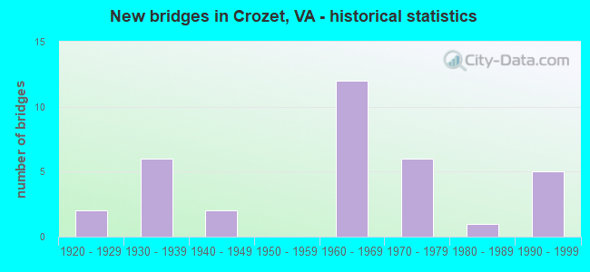
- New bridges - historical statistics
- 21920-1929
- 61930-1939
- 21940-1949
- 121960-1969
- 61970-1979
- 11980-1989
- 51990-1999

- Reconstructed bridges - Historical Statistics
- 11970-1979
- 01980-1989
- 41990-1999
- 12000-2009


- Bridge Condition - Deck
- 43.5%Good
- 34.8%Satisfactory
- 21.7%Fair

- Bridge Condition - Superstructure
- 4.3%Very good
- 26.1%Good
- 34.8%Satisfactory
- 21.7%Fair
- 13.0%Poor

- Bridge Condition - Substructure
- 47.8%Good
- 26.1%Satisfactory
- 26.1%Fair

- Bridge Condition - Channel
- 35.0%Good
- 40.0%Satisfactory
- 25.0%Fair
Find on map >> Show street view
Structure Number: 546, Location: 6.06NELSON C L/7.04 TO637 (Lat: 38.044647, Lng: -78.726339), Route carried "on" structure: Interstate 64, Year Built: 1969, Status: Open, Structure Length: 7.19m (23.59ft), Average Daily Traffic: 18,106 (year 2020), Truck Traffic: 11%, Average Future Daily Traffic: 25,348 (year 2040), Design Load: HS 20+Mod, Features Intersected: RTE 250-ROCKFISH GAP TK
Minimum Vertical Clearance: 30+ m (98+ ft), Kilometerpoint: 172.774, Lanes on structure: 2, Lanes under structure: 4, Base Highway Network: Yes, Owner: State Highway Agency, Approaching Roadway Width: 11.3m (37.1ft), Skew: 2 degrees, Material/Design: Prestressed concrete, Design/Construction: Stringer/Multi-beam, Number Of Spans In Main Unit: 4, Length of Maximum Span: 18.6m (61.0ft), Curb or Sidewalk Widths: Left: 0.2m (0.7ft), Right: 0.2m (0.7ft), Curb-To-Curb Width: 11.7m (38.4ft), Out-to-Out Width: 12.8m (42.0ft)
Condition: Deck: Good, Superstructure: Satisfactory, Substructure: Satisfactory, Operating Rating: 72.6 metric tons, Method Used To Determine Operating Rating: Load and Resistance Factor (LRFR), Inventory Rating: 49.0 metric tons, Method Used To Determine Inventory Rating: Load and Resistance Factor (LRFR), Structural Evaluation: Equal to present minimum criteria, Deck Geometry: Equal to present minimum criteria, Underclear: Meets minimum limits, Approach Roadway Alignment: Equal to present desirable criteria, Designated Inspection Frequency: Every 24 months, Inspection Date: August 2021, Deck Structure Type: Concrete Cast-file-Place, Wearing Surface/Protective System: Wearing Surface: Epoxy Overlay
Find on map >> Show street view
Structure Number: 548, Location: 6.06NELSON C L/7.04 TO637 (Lat: 38.044892, Lng: -78.725936), Route carried "on" structure: Interstate 64, Year Built: 1969, Status: Open, Structure Length: 7.19m (23.59ft), Average Daily Traffic: 15,834 (year 2020), Truck Traffic: 11%, Average Future Daily Traffic: 22,168 (year 2040), Design Load: HS 20+Mod, Features Intersected: RTE 250-ROCKFISH GAP TK
Minimum Vertical Clearance: 5.49m (18.01ft), Kilometerpoint: 172.694, Lanes on structure: 2, Lanes under structure: 4, Base Highway Network: Yes, Owner: State Highway Agency, Approaching Roadway Width: 11.3m (37.1ft), Skew: 2 degrees, Material/Design: Prestressed concrete, Design/Construction: Stringer/Multi-beam, Number Of Spans In Main Unit: 4, Length of Maximum Span: 18.6m (61.0ft), Curb or Sidewalk Widths: Left: 0.2m (0.7ft), Right: 0.2m (0.7ft), Curb-To-Curb Width: 11.7m (38.4ft), Out-to-Out Width: 12.8m (42.0ft)
Condition: Deck: Good, Superstructure: Satisfactory, Substructure: Satisfactory, Operating Rating: 72.6 metric tons, Method Used To Determine Operating Rating: Load and Resistance Factor (LRFR), Inventory Rating: 49.0 metric tons, Method Used To Determine Inventory Rating: Load and Resistance Factor (LRFR), Structural Evaluation: Equal to present minimum criteria, Deck Geometry: Equal to present minimum criteria, Underclear: Meets minimum limits, Approach Roadway Alignment: Equal to present desirable criteria, Designated Inspection Frequency: Every 24 months, Inspection Date: August 2021, Deck Structure Type: Concrete Cast-file-Place, Wearing Surface/Protective System: Wearing Surface: Epoxy Overlay
Find on map >> Show street view
Structure Number: 55, Location: 0.88 FR 250W/6.10 TO 637 (Lat: 38.039219, Lng: -78.711772), Route carried "on" structure: Interstate 64, Year Built: 1969, Status: Open, Structure Length: 11.94m (39.17ft), Average Daily Traffic: 18,106 (year 2020), Truck Traffic: 11%, Average Future Daily Traffic: 25,348 (year 2040), Design Load: HS 20+Mod, Features Intersected: STOCKTON CREEK
Minimum Vertical Clearance: 30+ m (98+ ft), Kilometerpoint: 174.206, Lanes on structure: 2, Base Highway Network: Yes, Owner: State Highway Agency, Approaching Roadway Width: 11.3m (37.1ft), Skew: 4 degrees, Material/Design: Steel continuous, Design/Construction: Stringer/Multi-beam, Number Of Spans In Main Unit: 3, Length of Maximum Span: 48.5m (159.1ft), Curb or Sidewalk Widths: Left: 0.2m (0.7ft), Right: 0.2m (0.7ft), Curb-To-Curb Width: 10.0m (32.8ft), Out-to-Out Width: 11.2m (36.7ft)
Condition: Deck: Good, Superstructure: Satisfactory, Substructure: Good, Channel: Good, Operating Rating: 52.6 metric tons, Method Used To Determine Operating Rating: Load and Resistance Factor (LRFR), Inventory Rating: 40.8 metric tons, Method Used To Determine Inventory Rating: Load and Resistance Factor (LRFR), Structural Evaluation: Equal to present minimum criteria, Deck Geometry: Meets minimum limits, Waterway Adequacy: Superior to present desirable criteria, Approach Roadway Alignment: Equal to present desirable criteria, Length Of Structure Improvement: 1.52m (4.99ft), Designated Inspection Frequency: Every 24 months, Inspection Date: October 2021, Bridge Improvement Cost: $450,000, Roadway Improvement Cost: $10,000, Total Project Cost: $460,000, Deck Structure Type: Concrete Cast-file-Place, Wearing Surface/Protective System: Wearing Surface: Latex Concrete
Find on map >> Show street view
Structure Number: 551, Location: 0.90 FR 250W/6.08 TO 637 (Lat: 38.039508, Lng: -78.711008), Route carried "on" structure: Interstate 64, Year Built: 1969, Status: Open, Structure Length: 11.29m (37.04ft), Average Daily Traffic: 18,085 (year 2020), Truck Traffic: 11%, Average Future Daily Traffic: 25,319 (year 2040), Design Load: HS 20+Mod, Features Intersected: STOCKTON CREEK
Minimum Vertical Clearance: 30+ m (98+ ft), Kilometerpoint: 174.158, Lanes on structure: 2, Base Highway Network: Yes, Owner: State Highway Agency, Approaching Roadway Width: 11.3m (37.1ft), Skew: 4 degrees, Material/Design: Steel continuous, Design/Construction: Stringer/Multi-beam, Number Of Spans In Main Unit: 3, Length of Maximum Span: 45.9m (150.6ft), Curb or Sidewalk Widths: Left: 0.2m (0.7ft), Right: 0.2m (0.7ft), Curb-To-Curb Width: 10.0m (32.8ft), Out-to-Out Width: 11.2m (36.7ft)
Condition: Deck: Satisfactory, Superstructure: Satisfactory, Substructure: Good, Channel: Good, Operating Rating: 48.1 metric tons, Method Used To Determine Operating Rating: Load and Resistance Factor (LRFR), Inventory Rating: 37.2 metric tons, Method Used To Determine Inventory Rating: Load and Resistance Factor (LRFR), Structural Evaluation: Equal to present minimum criteria, Deck Geometry: Meets minimum limits, Waterway Adequacy: Superior to present desirable criteria, Approach Roadway Alignment: Equal to present desirable criteria, Length Of Structure Improvement: 30.48m (100.00ft), Designated Inspection Frequency: Every 24 months, Inspection Date: October 2021, Bridge Improvement Cost: $160,000, Roadway Improvement Cost: $20,000, Total Project Cost: $180,000, Deck Structure Type: Concrete Cast-file-Place, Wearing Surface/Protective System: Wearing Surface: Latex Concrete
Find on map >> Show street view
Structure Number: 556, Location: 3.74 FR 250 / 3.24 TO 637 (Lat: 38.030153, Lng: -78.661158), Route carried "on" structure: Interstate 64, Year Built: 1969, Status: Open, Structure Length: 3.72m (12.20ft), Average Daily Traffic: 18,106 (year 2020), Truck Traffic: 11%, Average Future Daily Traffic: 25,348 (year 2040), Design Load: HS 20+Mod, Features Intersected: RTE 682 - BROAD AXE RD
Minimum Vertical Clearance: 30+ m (98+ ft), Kilometerpoint: 178.840, Lanes on structure: 2, Lanes under structure: 2, Base Highway Network: Yes, Owner: State Highway Agency, Approaching Roadway Width: 11.3m (37.1ft), Material/Design: Prestressed concrete, Design/Construction: Stringer/Multi-beam, Number Of Spans In Main Unit: 3, Length of Maximum Span: 15.2m (49.9ft), Curb-To-Curb Width: 11.7m (38.4ft), Out-to-Out Width: 12.8m (42.0ft)
Condition: Deck: Satisfactory, Superstructure: Fair, Substructure: Fair, Operating Rating: 78.9 metric tons, Method Used To Determine Operating Rating: Load and Resistance Factor (LRFR), Inventory Rating: 60.8 metric tons, Method Used To Determine Inventory Rating: Load and Resistance Factor (LRFR), Structural Evaluation: Somewhat better than minimum adequacy, Deck Geometry: Equal to present minimum criteria, Underclear: Equal to present minimum criteria, Approach Roadway Alignment: Equal to present desirable criteria, Designated Inspection Frequency: Every 24 months, Inspection Date: August 2021, Deck Structure Type: Concrete Cast-file-Place, Wearing Surface/Protective System: Wearing Surface: Epoxy Overlay
Find on map >> Show street view
Structure Number: 558, Location: 3.74 FR 250 / 3.24 TO 637 (Lat: 38.030589, Lng: -78.661114), Route carried "on" structure: Interstate 64, Year Built: 1969, Status: Open, Structure Length: 3.72m (12.20ft), Average Daily Traffic: 18,085 (year 2020), Truck Traffic: 11%, Average Future Daily Traffic: 25,319 (year 2040), Design Load: HS 20+Mod, Features Intersected: RTE 682 - BROAD AXE RD
Minimum Vertical Clearance: 30+ m (98+ ft), Kilometerpoint: 178.760, Lanes on structure: 2, Lanes under structure: 2, Base Highway Network: Yes, Owner: State Highway Agency, Approaching Roadway Width: 11.3m (37.1ft), Material/Design: Prestressed concrete, Design/Construction: Stringer/Multi-beam, Number Of Spans In Main Unit: 3, Length of Maximum Span: 15.2m (49.9ft), Curb or Sidewalk Widths: Left: 0.2m (0.7ft), Right: 0.2m (0.7ft), Curb-To-Curb Width: 11.7m (38.4ft), Out-to-Out Width: 12.8m (42.0ft)
Condition: Deck: Satisfactory, Superstructure: Fair, Substructure: Fair, Operating Rating: 78.9 metric tons, Method Used To Determine Operating Rating: Load and Resistance Factor (LRFR), Inventory Rating: 60.8 metric tons, Method Used To Determine Inventory Rating: Load and Resistance Factor (LRFR), Structural Evaluation: Somewhat better than minimum adequacy, Deck Geometry: Equal to present minimum criteria, Underclear: Equal to present minimum criteria, Approach Roadway Alignment: Equal to present desirable criteria, Designated Inspection Frequency: Every 24 months, Inspection Date: August 2021, Deck Structure Type: Concrete Cast-file-Place, Wearing Surface/Protective System: Wearing Surface: Epoxy Overlay
Find on map >> Show street view
Structure Number: 589, Location: 0.66 FR 250W/1.41 TO 810 (Lat: 38.060053, Lng: -78.700536), Route carried "on" structure: State highway 240, Year Built: 1921, Status: Open, Structure Length: 1.68m (5.51ft), Average Daily Traffic: 6,598 (year 2020), Truck Traffic: 3%, Average Future Daily Traffic: 8,587 (year 2040), Design Load: H 15, Features Intersected: LICKINGHOLE CREEK, Facility Carried by Structure: CROZET AVENUE
Minimum Vertical Clearance: 30+ m (98+ ft), Kilometerpoint: 1.078, Lanes on structure: 2, Owner: State Highway Agency, Approaching Roadway Width: 6.7m (22.0ft), Material/Design: Concrete, Design/Construction: Tee Beam, Number Of Spans In Main Unit: 2, Length of Maximum Span: 8.5m (27.9ft), Curb or Sidewalk Widths: Left: 0.5m (1.6ft), Right: 0.5m (1.6ft), Curb-To-Curb Width: 7.9m (25.9ft), Out-to-Out Width: 9.4m (30.8ft)
Condition: Deck: Fair, Superstructure: Poor, Substructure: Fair, Channel: Fair, Operating Rating: 49.0 metric tons, Method Used To Determine Operating Rating: Load Factor (LF), Inventory Rating: 29.0 metric tons, Method Used To Determine Inventory Rating: Load Factor (LF), Structural Evaluation: Meets minimum limits, Deck Geometry: High priority of replacement, Waterway Adequacy: Equal to present minimum criteria, Approach Roadway Alignment: Equal to present minimum criteria, Length Of Structure Improvement: 1.68m (5.51ft), Designated Inspection Frequency: Every 12 months, Inspection Date: May 2021, Bridge Improvement Cost: $185,000, Roadway Improvement Cost: $25,000, Total Project Cost: $225,000, Deck Structure Type: Concrete Cast-file-Place, Wearing Surface/Protective System: Wearing Surface: Bituminous
Find on map >> Show street view
Structure Number: 591, Location: 0.46 FR 802/0.22 TO 250E (Lat: 38.062881, Lng: -78.651869), Route carried "on" structure: State highway 240, Year Built: 1921, Year Reconstructed: 1995, Status: Open, Structure Length: 2.65m (8.69ft), Average Daily Traffic: 5,774 (year 2020), Truck Traffic: 4%, Average Future Daily Traffic: 7,799 (year 2040), Design Load: HS 20+Mod, Features Intersected: LICKINGHOLE CREEK, Facility Carried by Structure: THREE NOTCH'D ROAD
Minimum Vertical Clearance: 30+ m (98+ ft), Kilometerpoint: 6.909, Lanes on structure: 2, Base Highway Network: Yes, Owner: State Highway Agency, Approaching Roadway Width: 6.7m (22.0ft), Skew: 4 degrees, Material/Design: Prestressed concrete, Design/Construction: Slab, Number Of Spans In Main Unit: 1, Length of Maximum Span: 25.1m (82.3ft), Curb-To-Curb Width: 10.0m (32.8ft), Out-to-Out Width: 11.0m (36.1ft)
Condition: Deck: Good, Superstructure: Good, Substructure: Good, Channel: Satisfactory, Operating Rating: 89.8 metric tons, Method Used To Determine Operating Rating: Load and Resistance Factor (LRFR), Inventory Rating: 89.8 metric tons, Method Used To Determine Inventory Rating: Load and Resistance Factor (LRFR), Structural Evaluation: Better than present minimum criteria, Deck Geometry: Meets minimum limits, Waterway Adequacy: Equal to present minimum criteria, Approach Roadway Alignment: Better than present minimum criteria, Designated Inspection Frequency: Every 24 months, Inspection Date: May 2021, Deck Structure Type: Other, Wearing Surface/Protective System: Wearing Surface: Bituminous, Membrane: Epoxy
Find on map >> Show street view
Structure Number: 592, Location: 0.45 FR 250/0.01 TO 1231 (Lat: 38.057267, Lng: -78.699119), Route carried "on" structure: State highway 240, Year Built: 1990, Status: Open, Structure Length: 0.61m (2.00ft), Average Daily Traffic: 6,598 (year 2020), Truck Traffic: 3%, Average Future Daily Traffic: 8,587 (year 2040), Design Load: HS 20+Mod, Features Intersected: SLABTOWN BRANCH, Facility Carried by Structure: CROZET AVENUE
Minimum Vertical Clearance: 30+ m (98+ ft), Kilometerpoint: 0.724, Lanes on structure: 2, Owner: State Highway Agency, Approaching Roadway Width: 6.1m (20.0ft), Skew: 3 degrees, Material/Design: Concrete, Design/Construction: Culvert, Number Of Spans In Main Unit: 2, Length of Maximum Span: 3.0m (9.8ft)
Condition: Channel: Fair, Culverts: Good, Operating Rating: 89.8 metric tons, Method Used To Determine Operating Rating: Load Factor (LF), Inventory Rating: 89.8 metric tons, Method Used To Determine Inventory Rating: Load Factor (LF), Structural Evaluation: Better than present minimum criteria, Waterway Adequacy: Somewhat better than minimum adequacy, Approach Roadway Alignment: Equal to present desirable criteria, Designated Inspection Frequency: Every 24 months, Inspection Date: May 2020
Find on map >> Show street view
Structure Number: 598, Location: 0.01 FR 240 / 0.27 TO 682 (Lat: 38.061936, Lng: -78.648111), Route carried "on" structure: US 250, Year Built: 1942, Status: Open, Structure Length: 6.46m (21.19ft), Average Daily Traffic: 10,630 (year 2020), Truck Traffic: 2%, Average Future Daily Traffic: 14,882 (year 2040), Design Load: H 15, Features Intersected: MECHUMS RIVER, Facility Carried by Structure: IVY ROAD
Minimum Vertical Clearance: 30+ m (98+ ft), Kilometerpoint: 138.036, Lanes on structure: 2, Base Highway Network: Yes, Owner: State Highway Agency, Approaching Roadway Width: 9.1m (29.9ft), Material/Design: Steel, Design/Construction: Stringer/Multi-beam, Number Of Spans In Main Unit: 4, Length of Maximum Span: 16.5m (54.1ft), Curb or Sidewalk Widths: Left: 0.2m (0.7ft), Right: 0.2m (0.7ft), Curb-To-Curb Width: 13.4m (44.0ft), Out-to-Out Width: 14.4m (47.2ft)
Condition: Deck: Satisfactory, Superstructure: Fair, Substructure: Fair, Channel: Satisfactory, Operating Rating: 49.0 metric tons, Method Used To Determine Operating Rating: Load and Resistance Factor (LRFR), Inventory Rating: 37.2 metric tons, Method Used To Determine Inventory Rating: Load and Resistance Factor (LRFR), Structural Evaluation: Somewhat better than minimum adequacy, Deck Geometry: Equal to present minimum criteria, Waterway Adequacy: Equal to present minimum criteria, Approach Roadway Alignment: Equal to present minimum criteria, Designated Inspection Frequency: Every 24 months, Inspection Date: June 2020, Deck Structure Type: Concrete Cast-file-Place, Wearing Surface/Protective System: Wearing Surface: Monolithic Concrete, Deck Protection: Epoxy Coated Reinforcing
Find on map >> Show street view
Structure Number: 654, Location: 0.45 FR 674 / 1.93 TO 810 (Lat: 38.128061, Lng: -78.693025), Route carried "on" structure: County highway 614, Year Built: 1932, Year Reconstructed: 2009, Status: Open, Structure Length: 2.22m (7.28ft), Average Daily Traffic: 242 (year 2015), Average Future Daily Traffic: 272 (year 2040), Features Intersected: MOORMANS RIVER, Facility Carried by Structure: SUGAR HOLLOW ROAD
Minimum Vertical Clearance: 30+ m (98+ ft), Kilometerpoint: 6.689, Lanes on structure: 1, Owner: State Highway Agency, Approaching Roadway Width: 6.1m (20.0ft), Material/Design: Steel, Design/Construction: Stringer/Multi-beam, Number Of Spans In Main Unit: 3, Length of Maximum Span: 8.9m (29.2ft), Curb or Sidewalk Widths: Left: 0.2m (0.7ft), Right: 0.2m (0.7ft), Curb-To-Curb Width: 4.9m (16.1ft), Out-to-Out Width: 4.9m (16.1ft)
Condition: Deck: Satisfactory, Superstructure: Very good, Substructure: Good, Channel: Fair, Operating Rating: 68.9 metric tons, Method Used To Determine Operating Rating: Load Factor (LF), Inventory Rating: 40.8 metric tons, Method Used To Determine Inventory Rating: Load Factor (LF), Structural Evaluation: Better than present minimum criteria, Deck Geometry: High priority of replacement, Waterway Adequacy: Equal to present minimum criteria, Approach Roadway Alignment: High priority of corrective action, Length Of Structure Improvement: 2.90m (9.51ft), Designated Inspection Frequency: Every 24 months, Inspection Date: January 2021, Bridge Improvement Cost: $280,000, Roadway Improvement Cost: $50,000, Total Project Cost: $350,000, Deck Structure Type: Wood or Timber
Find on map >> Show street view
Structure Number: 692, Location: .18 FR 637S / .17 TO 637N (Lat: 38.014222, Lng: -78.701386), Route carried "on" structure: County highway 635, Year Built: 1973, Status: Open, Structure Length: 3.26m (10.70ft), Average Daily Traffic: 1,714 (year 2020), Truck Traffic: 3%, Average Future Daily Traffic: 2,400 (year 2040), Design Load: HS 20+Mod, Features Intersected: MECHUMS RIVER, Facility Carried by Structure: MILLER SCHOOL ROAD
Minimum Vertical Clearance: 30+ m (98+ ft), Kilometerpoint: 11.118, Lanes on structure: 2, Owner: State Highway Agency, Approaching Roadway Width: 6.1m (20.0ft), Skew: 1 degrees, Material/Design: Steel continuous, Design/Construction: Stringer/Multi-beam, Number Of Spans In Main Unit: 2, Length of Maximum Span: 16.0m (52.5ft), Curb-To-Curb Width: 8.5m (27.9ft), Out-to-Out Width: 9.8m (32.2ft)
Condition: Deck: Fair, Superstructure: Fair, Substructure: Satisfactory, Channel: Good, Operating Rating: 65.3 metric tons, Method Used To Determine Operating Rating: Load and Resistance Factor (LRFR), Inventory Rating: 50.8 metric tons, Method Used To Determine Inventory Rating: Load and Resistance Factor (LRFR), Structural Evaluation: Somewhat better than minimum adequacy, Deck Geometry: Somewhat better than minimum adequacy, Waterway Adequacy: Equal to present minimum criteria, Approach Roadway Alignment: Equal to present minimum criteria, Designated Inspection Frequency: Every 24 months, Inspection Date: November 2020, Deck Structure Type: Concrete Cast-file-Place
Find on map >> Show street view
Structure Number: 694, Location: 1.26 FR 688 / 0.56 TO 250 (Lat: 38.043183, Lng: -78.698164), Route carried "on" structure: County highway 635, Year Built: 1973, Status: Open, Structure Length: 2.80m (9.19ft), Average Daily Traffic: 1,714 (year 2020), Truck Traffic: 3%, Average Future Daily Traffic: 2,400 (year 2040), Design Load: HS 20+Mod, Features Intersected: STOCKTON CREEK, Facility Carried by Structure: MILLER SCHOOL ROAD
Minimum Vertical Clearance: 30+ m (98+ ft), Kilometerpoint: 14.722, Lanes on structure: 2, Owner: State Highway Agency, Approaching Roadway Width: 6.1m (20.0ft), Skew: 3 degrees, Material/Design: Concrete continuous, Design/Construction: Slab, Number Of Spans In Main Unit: 3, Length of Maximum Span: 10.7m (35.1ft), Curb-To-Curb Width: 8.5m (27.9ft), Out-to-Out Width: 9.9m (32.5ft)
Condition: Deck: Fair, Superstructure: Fair, Substructure: Good, Channel: Good, Operating Rating: 59.0 metric tons, Method Used To Determine Operating Rating: Load and Resistance Factor (LRFR), Inventory Rating: 45.4 metric tons, Method Used To Determine Inventory Rating: Load and Resistance Factor (LRFR), Structural Evaluation: Somewhat better than minimum adequacy, Deck Geometry: Somewhat better than minimum adequacy, Waterway Adequacy: Better than present minimum criteria, Approach Roadway Alignment: Equal to present desirable criteria, Designated Inspection Frequency: Every 24 months, Inspection Date: November 2020, Deck Structure Type: Concrete Cast-file-Place
Find on map >> Show street view
Structure Number: 696, Location: 1.09 TO 250 / 0.67 FR 688 (Lat: 38.036539, Lng: -78.702181), Route carried "on" structure: County highway 635, Year Built: 1969, Status: Open, Structure Length: 11.10m (36.42ft), Average Daily Traffic: 1,714 (year 2020), Truck Traffic: 3%, Average Future Daily Traffic: 2,400 (year 2040), Design Load: HS 20+Mod, Features Intersected: INTERSTATE 64 EBL & WBL, Facility Carried by Structure: MILLER SCHOOL ROAD
Minimum Vertical Clearance: 30+ m (98+ ft), Kilometerpoint: 13.773, Lanes on structure: 2, Lanes under structure: 4, Owner: State Highway Agency, Approaching Roadway Width: 6.1m (20.0ft), Skew: 1 degrees, Material/Design: Prestressed concrete, Design/Construction: Stringer/Multi-beam, Number Of Spans In Main Unit: 6, Length of Maximum Span: 20.1m (65.9ft), Curb or Sidewalk Widths: Left: 0.2m (0.7ft), Right: 0.2m (0.7ft), Curb-To-Curb Width: 8.7m (28.5ft), Out-to-Out Width: 9.8m (32.2ft)
Condition: Deck: Satisfactory, Superstructure: Satisfactory, Substructure: Satisfactory, Operating Rating: 69.8 metric tons, Method Used To Determine Operating Rating: Load and Resistance Factor (LRFR), Inventory Rating: 53.8 metric tons, Method Used To Determine Inventory Rating: Load and Resistance Factor (LRFR), Structural Evaluation: Equal to present minimum criteria, Deck Geometry: Somewhat better than minimum adequacy, Underclear: Somewhat better than minimum adequacy, Approach Roadway Alignment: Equal to present minimum criteria, Designated Inspection Frequency: Every 24 months, Inspection Date: August 2020, Deck Structure Type: Concrete Cast-file-Place, Wearing Surface/Protective System: Wearing Surface: Epoxy Overlay
Find on map >> Show street view
Structure Number: 749, Location: 0.84 FR 751/0.36 DEAD END (Lat: 38.040275, Lng: -78.683219), Route carried "on" structure: County highway 683, Year Built: 1932, Year Reconstructed: 2001, Status: Open, Structure Length: 1.04m (3.41ft), Average Daily Traffic: 110 (year 2015), Average Future Daily Traffic: 148 (year 2040), Features Intersected: STOCKTON CREEK, Facility Carried by Structure: SHELTONS MILL ROAD
Minimum Vertical Clearance: 30+ m (98+ ft), Kilometerpoint: 0.570, Lanes on structure: 1, Owner: State Highway Agency, Approaching Roadway Width: 3.4m (11.2ft), Material/Design: Steel, Design/Construction: Stringer/Multi-beam, Number Of Spans In Main Unit: 1, Length of Maximum Span: 10.4m (34.1ft), Curb-To-Curb Width: 4.2m (13.8ft), Out-to-Out Width: 4.9m (16.1ft)
Condition: Deck: Good, Superstructure: Good, Substructure: Satisfactory, Channel: Good, Operating Rating: 59.9 metric tons, Method Used To Determine Operating Rating: Load Factor (LF), Inventory Rating: 36.3 metric tons, Method Used To Determine Inventory Rating: Load Factor (LF), Structural Evaluation: Equal to present minimum criteria, Deck Geometry: High priority of replacement, Waterway Adequacy: Equal to present minimum criteria, Approach Roadway Alignment: Meets minimum limits, Length Of Structure Improvement: 1.83m (6.00ft), Designated Inspection Frequency: Every 24 months, Inspection Date: November 2021, Bridge Improvement Cost: $135,000, Roadway Improvement Cost: $20,000, Total Project Cost: $175,000, Deck Structure Type: Wood or Timber
Find on map >> Show street view
Structure Number: 75, Location: 0.30 FR 788/1.50 DEAD END (Lat: 38.081006, Lng: -78.718383), Route carried "on" structure: County highway 684, Year Built: 1980, Status: Open, Structure Length: 0.88m (2.89ft), Average Daily Traffic: 510 (year 2018), Average Future Daily Traffic: 512 (year 2040), Design Load: HS 20+Mod, Features Intersected: POWELLS CREEK, Facility Carried by Structure: MINT SPRINGS ROAD
Minimum Vertical Clearance: 30+ m (98+ ft), Kilometerpoint: 4.827, Lanes on structure: 2, Owner: State Highway Agency, Approaching Roadway Width: 6.7m (22.0ft), Skew: 4 degrees, Material/Design: Concrete, Design/Construction: Culvert, Number Of Spans In Main Unit: 2, Length of Maximum Span: 4.6m (15.1ft)
Condition: Channel: Satisfactory, Culverts: Good, Operating Rating: 44.5 metric tons, Method Used To Determine Operating Rating: Field evaluation and documented engineering judgment, Inventory Rating: 32.7 metric tons, Method Used To Determine Inventory Rating: Field evaluation and documented engineering judgment, Structural Evaluation: Better than present minimum criteria, Waterway Adequacy: Equal to present minimum criteria, Approach Roadway Alignment: Equal to present desirable criteria, Designated Inspection Frequency: Every 24 months, Inspection Date: November 2021
Find on map >> Show street view
Structure Number: 751, Location: 1.43 FR 797 / 0.07 TO 691 (Lat: 38.065656, Lng: -78.726933), Route carried "on" structure: County highway 684, Year Built: 1932, Status: Open, Structure Length: 0.85m (2.79ft), Average Daily Traffic: 1,340 (year 2015), Average Future Daily Traffic: 2,010 (year 2040), Features Intersected: LICKINGHOLE CREEK, Facility Carried by Structure: HALF MILE BR. RD
Minimum Vertical Clearance: 30+ m (98+ ft), Kilometerpoint: 2.301, Lanes on structure: 2, Owner: State Highway Agency, Approaching Roadway Width: 4.9m (16.1ft), Material/Design: Steel, Design/Construction: Stringer/Multi-beam, Number Of Spans In Main Unit: 1, Length of Maximum Span: 8.5m (27.9ft), Curb or Sidewalk Widths: Left: 0.2m (0.7ft), Right: 0.2m (0.7ft), Curb-To-Curb Width: 6.1m (20.0ft), Out-to-Out Width: 6.4m (21.0ft)
Condition: Deck: Satisfactory, Superstructure: Satisfactory, Substructure: Fair, Channel: Good, Operating Rating: 53.5 metric tons, Method Used To Determine Operating Rating: Load Factor (LF), Inventory Rating: 31.8 metric tons, Method Used To Determine Inventory Rating: Load Factor (LF), Structural Evaluation: Somewhat better than minimum adequacy, Deck Geometry: High priority of replacement, Waterway Adequacy: Equal to present minimum criteria, Approach Roadway Alignment: Equal to present minimum criteria, Length Of Structure Improvement: 1.22m (4.00ft), Designated Inspection Frequency: Every 24 months, Inspection Date: November 2020, Bridge Improvement Cost: $140,000, Roadway Improvement Cost: $35,000, Total Project Cost: $200,000, Deck Structure Type: Concrete Cast-file-Place, Wearing Surface/Protective System: Wearing Surface: Bituminous
Find on map >> Show street view
Structure Number: 754, Location: 0.20 FR 250 / 1.15 TO 688 (Lat: 38.040322, Lng: -78.732617), Route carried "on" structure: County highway 689, Year Built: 1932, Year Reconstructed: 1979, Status: Posted for load, Structure Length: 1.40m (4.59ft), Average Daily Traffic: 558 (year 2018), Average Future Daily Traffic: 804 (year 2040), Design Load: HS 20+Mod, Features Intersected: STOCKTON CREEK, Facility Carried by Structure: BURCHS CREEK ROAD
Minimum Vertical Clearance: 30+ m (98+ ft), Kilometerpoint: 0.322, Lanes on structure: 2, Owner: State Highway Agency, Approaching Roadway Width: 5.5m (18.0ft), Material/Design: Steel, Design/Construction: Stringer/Multi-beam, Number Of Spans In Main Unit: 1, Length of Maximum Span: 14.0m (45.9ft), Curb-To-Curb Width: 7.5m (24.6ft), Out-to-Out Width: 8.1m (26.6ft)
Condition: Deck: Fair, Superstructure: Poor, Substructure: Satisfactory, Channel: Satisfactory, Operating Rating: 28.1 metric tons, Method Used To Determine Operating Rating: Load and Resistance Factor (LRFR), Inventory Rating: 16.3 metric tons, Method Used To Determine Inventory Rating: Load and Resistance Factor (LRFR), Structural Evaluation: Meets minimum limits, Deck Geometry: Meets minimum limits, Waterway Adequacy: Better than present minimum criteria, Approach Roadway Alignment: High priority of corrective action, Bridge Posting: Required (Relationship of Operating Rating to Maximum Legal Load: 10.0 - 19.9% below), Designated Inspection Frequency: Every 3 months, Inspection Date: March 2022, Deck Structure Type: Wood or Timber
Find on map >> Show street view
Structure Number: 755, Location: 0.77 FR 250 / 0.58 TO 688 (Lat: 38.034481, Lng: -78.728167), Route carried "on" structure: County highway 689, Year Built: 1976, Status: Open, Structure Length: 0.79m (2.59ft), Average Daily Traffic: 558 (year 2018), Average Future Daily Traffic: 804 (year 2040), Design Load: HS 20, Features Intersected: YELLOW MOUNTAIN CREEK, Facility Carried by Structure: BURCHS CREEK ROAD
Minimum Vertical Clearance: 30+ m (98+ ft), Kilometerpoint: 1.232, Lanes on structure: 2, Owner: State Highway Agency, Approaching Roadway Width: 4.9m (16.1ft), Material/Design: Concrete, Design/Construction: Culvert, Number Of Spans In Main Unit: 3, Length of Maximum Span: 1.8m (5.9ft)
Condition: Channel: Fair, Culverts: Good, Operating Rating: 44.5 metric tons, Method Used To Determine Operating Rating: Field evaluation and documented engineering judgment, Inventory Rating: 32.7 metric tons, Method Used To Determine Inventory Rating: Field evaluation and documented engineering judgment, Structural Evaluation: Better than present minimum criteria, Waterway Adequacy: Equal to present desirable criteria, Approach Roadway Alignment: Equal to present minimum criteria, Length Of Structure Improvement: 0.70m (2.30ft), Designated Inspection Frequency: Every 24 months, Inspection Date: November 2021, Bridge Improvement Cost: $120,000, Roadway Improvement Cost: $50,000, Total Project Cost: $200,000
Find on map >> Show street view
Structure Number: 759, Location: 0.65 FR 691 / 0.44 TO 250 (Lat: 38.045067, Lng: -78.751489), Route carried "on" structure: County highway 690, Year Built: 1972, Status: Open, Structure Length: 7.50m (24.61ft), Average Daily Traffic: 683 (year 2018), Average Future Daily Traffic: 815 (year 2040), Design Load: HS 20+Mod, Features Intersected: INTERSTATE 64 EBL & WBL, Facility Carried by Structure: GREENWOOD STA. RD.
Minimum Vertical Clearance: 30+ m (98+ ft), Kilometerpoint: 6.475, Lanes on structure: 2, Lanes under structure: 4, Base Highway Network: Yes, Owner: State Highway Agency, Approaching Roadway Width: 5.5m (18.0ft), Skew: 1 degrees, Material/Design: Steel, Design/Construction: Stringer/Multi-beam, Number Of Spans In Main Unit: 2, Length of Maximum Span: 38.1m (125.0ft), Curb or Sidewalk Widths: Left: 0.2m (0.7ft), Right: 0.2m (0.7ft), Curb-To-Curb Width: 10.0m (32.8ft), Out-to-Out Width: 11.2m (36.7ft)
Condition: Deck: Good, Superstructure: Good, Substructure: Good, Operating Rating: 71.7 metric tons, Method Used To Determine Operating Rating: Load and Resistance Factor (LRFR), Inventory Rating: 54.4 metric tons, Method Used To Determine Inventory Rating: Load and Resistance Factor (LRFR), Structural Evaluation: Better than present minimum criteria, Deck Geometry: Equal to present minimum criteria, Underclear: Better than present minimum criteria, Approach Roadway Alignment: Equal to present desirable criteria, Designated Inspection Frequency: Every 24 months, Inspection Date: August 2020, Deck Structure Type: Concrete Cast-file-Place, Wearing Surface/Protective System: Wearing Surface: Epoxy Overlay
Find on map >> Show street view
Structure Number: 763, Location: 1.59 FR 692 / 0.01 TO 250 (Lat: 38.035914, Lng: -78.757164), Route carried "on" structure: County highway 691, Year Built: 1946, Year Reconstructed: 1998, Status: Open, Structure Length: 2.07m (6.79ft), Average Daily Traffic: 582 (year 2020), Truck Traffic: 4%, Average Future Daily Traffic: 698 (year 2040), Design Load: H 15, Features Intersected: STOCKTON CREEK, Facility Carried by Structure: ORTMAN ROAD
Minimum Vertical Clearance: 30+ m (98+ ft), Kilometerpoint: 11.311, Lanes on structure: 2, Owner: State Highway Agency, Approaching Roadway Width: 5.2m (17.1ft), Material/Design: Prestressed concrete, Design/Construction: Slab, Number Of Spans In Main Unit: 1, Length of Maximum Span: 20.7m (67.9ft), Curb-To-Curb Width: 7.5m (24.6ft), Out-to-Out Width: 8.2m (26.9ft)
Condition: Deck: Good, Superstructure: Good, Substructure: Good, Channel: Good, Operating Rating: 75.6 metric tons, Method Used To Determine Operating Rating: Load Factor (LF), Inventory Rating: 45.0 metric tons, Method Used To Determine Inventory Rating: Load Factor (LF), Structural Evaluation: Better than present minimum criteria, Deck Geometry: Meets minimum limits, Waterway Adequacy: Better than present minimum criteria, Approach Roadway Alignment: Equal to present minimum criteria, Designated Inspection Frequency: Every 24 months, Inspection Date: November 2020, Deck Structure Type: Other, Wearing Surface/Protective System: Wearing Surface: Bituminous
Find on map >> Show street view
Structure Number: 862, Location: 0.60 FR 614 / 0.60 TO 674 (Lat: 38.126989, Lng: -78.661211), Route carried "on" structure: County highway 810, Year Built: 1932, Year Reconstructed: 1999, Status: Open, Structure Length: 2.62m (8.60ft), Average Daily Traffic: 1,492 (year 2020), Truck Traffic: 5%, Average Future Daily Traffic: 1,591 (year 2040), Design Load: H 15, Features Intersected: MOORMANS RIVER, Facility Carried by Structure: BROWNS GAP TURNPIK
Minimum Vertical Clearance: 30+ m (98+ ft), Kilometerpoint: 8.286, Lanes on structure: 2, Owner: State Highway Agency, Approaching Roadway Width: 5.5m (18.0ft), Material/Design: Prestressed concrete, Design/Construction: Slab, Number Of Spans In Main Unit: 2, Length of Maximum Span: 13.1m (43.0ft), Curb-To-Curb Width: 7.1m (23.3ft), Out-to-Out Width: 7.3m (24.0ft)
Condition: Deck: Good, Superstructure: Good, Substructure: Good, Channel: Satisfactory, Operating Rating: 78.0 metric tons, Method Used To Determine Operating Rating: Load and Resistance Factor (LRFR), Inventory Rating: 59.9 metric tons, Method Used To Determine Inventory Rating: Load and Resistance Factor (LRFR), Structural Evaluation: Better than present minimum criteria, Deck Geometry: High priority of corrective action, Waterway Adequacy: Better than present minimum criteria, Approach Roadway Alignment: Equal to present minimum criteria, Length Of Structure Improvement: 2.74m (8.99ft), Designated Inspection Frequency: Every 24 months, Inspection Date: January 2022, Bridge Improvement Cost: $220,000, Roadway Improvement Cost: $40,000, Total Project Cost: $275,000, Deck Structure Type: Other, Wearing Surface/Protective System: Wearing Surface: Bituminous, Membrane: Epoxy, Deck Protection: Epoxy Coated Reinforcing
Find on map >> Show street view
Structure Number: 881, Location: 0.80 FR 250/0.83 TO 688 (Lat: 38.037986, Lng: -78.717511), Route carried "on" structure: County highway 824, Year Built: 1932, Status: Posted for load, Structure Length: 1.28m (4.20ft), Average Daily Traffic: 161 (year 2018), Average Future Daily Traffic: 232 (year 2040), Features Intersected: STOCKTON CREEK, Facility Carried by Structure: PATTERSON MILL LN.
Minimum Vertical Clearance: 30+ m (98+ ft), Kilometerpoint: 1.287, Lanes on structure: 2, Owner: State Highway Agency, Approaching Roadway Width: 4.9m (16.1ft), Material/Design: Steel, Design/Construction: Stringer/Multi-beam, Number Of Spans In Main Unit: 2, Length of Maximum Span: 6.4m (21.0ft), Curb or Sidewalk Widths: Left: 0.2m (0.7ft), Right: 0.2m (0.7ft), Curb-To-Curb Width: 5.4m (17.7ft), Out-to-Out Width: 5.8m (19.0ft)
Condition: Deck: Good, Superstructure: Poor, Substructure: Fair, Channel: Satisfactory, Operating Rating: 20.9 metric tons, Method Used To Determine Operating Rating: Load and Resistance Factor (LRFR), Inventory Rating: 16.3 metric tons, Method Used To Determine Inventory Rating: Load and Resistance Factor (LRFR), Structural Evaluation: Meets minimum limits, Deck Geometry: High priority of replacement, Waterway Adequacy: Equal to present minimum criteria, Approach Roadway Alignment: Equal to present minimum criteria, Bridge Posting: Required (Relationship of Operating Rating to Maximum Legal Load: 30.0 - 39.9% below), Length Of Structure Improvement: 1.68m (5.51ft), Designated Inspection Frequency: Every 12 months, Inspection Date: June 2021, Bridge Improvement Cost: $145,000, Roadway Improvement Cost: $20,000, Total Project Cost: $180,000, Deck Structure Type: Wood or Timber
Find on map >> Show street view
Structure Number: 24128, Location: 0.08 FR 1207/0.33 TO D.E. (Lat: 38.076228, Lng: -78.713083), Route carried "on" structure: County highway 1226, Year Built: 1994, Status: Open, Structure Length: 0.67m (2.20ft), Average Daily Traffic: 310 (year 2018), Average Future Daily Traffic: 446 (year 2040), Design Load: HS 20, Features Intersected: POWELLS CREEK, Facility Carried by Structure: CLING LANE
Minimum Vertical Clearance: 30+ m (98+ ft), Kilometerpoint: 0.290, Lanes on structure: 2, Owner: State Highway Agency, Approaching Roadway Width: 6.1m (20.0ft), Skew: 2 degrees, Material/Design: Concrete, Design/Construction: Culvert, Number Of Spans In Main Unit: 2, Length of Maximum Span: 3.4m (11.2ft)
Condition: Channel: Fair, Culverts: Good, Operating Rating: 44.5 metric tons, Method Used To Determine Operating Rating: Load Factor (LF), Inventory Rating: 32.7 metric tons, Method Used To Determine Inventory Rating: Load Factor (LF), Structural Evaluation: Better than present minimum criteria, Waterway Adequacy: Equal to present desirable criteria, Approach Roadway Alignment: Equal to present desirable criteria, Designated Inspection Frequency: Every 24 months, Inspection Date: November 2020
Find on map >> Show street view
Structure Number: 25557, Location: 0.12 FR 1251/O.66 TO 240 (Lat: 38.068086, Lng: -78.675742), Route carried "on" structure: County highway 1250, Year Built: 1996, Status: Open, Structure Length: 1.68m (5.51ft), Average Daily Traffic: 1,624 (year 2018), Average Future Daily Traffic: 1,803 (year 2040), Design Load: HS 20+Mod, Features Intersected: BUCKINGHAM BRANCH RR, Facility Carried by Structure: PARK RIDGE DRIVE
Minimum Vertical Clearance: 30+ m (98+ ft), Kilometerpoint: 0.193, Lanes on structure: 2, Owner: State Highway Agency, Approaching Roadway Width: 8.5m (27.9ft), Material/Design: Prestressed concrete, Design/Construction: Slab, Number Of Spans In Main Unit: 1, Length of Maximum Span: 16.2m (53.1ft), Curb or Sidewalk Widths: Left: 1.6m (5.2ft), Right: 0.0m, Curb-To-Curb Width: 8.5m (27.9ft), Out-to-Out Width: 11.0m (36.1ft)
Condition: Deck: Good, Superstructure: Good, Substructure: Good, Operating Rating: 89.8 metric tons, Method Used To Determine Operating Rating: Load and Resistance Factor (LRFR), Inventory Rating: 72.6 metric tons, Method Used To Determine Inventory Rating: Load and Resistance Factor (LRFR), Structural Evaluation: Better than present minimum criteria, Deck Geometry: Somewhat better than minimum adequacy, Underclear: Superior to present desirable criteria, Approach Roadway Alignment: Equal to present desirable criteria, Designated Inspection Frequency: Every 24 months, Inspection Date: November 2021, Deck Structure Type: Other, Wearing Surface/Protective System: Wearing Surface: Bituminous
Find on map >> Show street view
Structure Number: 25692, Location: 3.28 FR D E / 0.42 TO 674 (Lat: 38.128906, Lng: -78.707533), Route carried "on" structure: County highway 614, Year Built: 1998, Status: Open, Structure Length: 1.98m (6.50ft), Average Daily Traffic: 148 (year 2015), Average Future Daily Traffic: 195 (year 2040), Design Load: HS 20, Features Intersected: MOORMANS RIVER, Facility Carried by Structure: SUGAR HOLLOW ROAD
Minimum Vertical Clearance: 30+ m (98+ ft), Kilometerpoint: 5.282, Lanes on structure: 1, Owner: State Highway Agency, Approaching Roadway Width: 5.5m (18.0ft), Skew: 3 degrees, Material/Design: Steel, Design/Construction: Stringer/Multi-beam, Number Of Spans In Main Unit: 1, Length of Maximum Span: 19.8m (65.0ft), Curb-To-Curb Width: 5.4m (17.7ft), Out-to-Out Width: 6.1m (20.0ft)
Condition: Deck: Fair, Superstructure: Satisfactory, Substructure: Good, Channel: Satisfactory, Operating Rating: 59.9 metric tons, Method Used To Determine Operating Rating: Load and Resistance Factor (LRFR), Inventory Rating: 46.3 metric tons, Method Used To Determine Inventory Rating: Load and Resistance Factor (LRFR), Structural Evaluation: Equal to present minimum criteria, Deck Geometry: High priority of replacement, Waterway Adequacy: Equal to present minimum criteria, Approach Roadway Alignment: Equal to present minimum criteria, Length Of Structure Improvement: 2.29m (7.51ft), Designated Inspection Frequency: Every 24 months, Inspection Date: January 2021, Bridge Improvement Cost: $100,000, Roadway Improvement Cost: $100,000, Total Project Cost: $250,000, Deck Structure Type: Wood or Timber
Find on map >> Show street view
Structure Number: 2581, Location: 2.28 FR D E / 1.42 TO 674 (Lat: 38.127558, Lng: -78.720064), Route carried "on" structure: County highway 614, Year Built: 1998, Status: Open, Structure Length: 1.98m (6.50ft), Average Daily Traffic: 148 (year 2015), Average Future Daily Traffic: 195 (year 2040), Design Load: HS 20, Features Intersected: MOORMANS RIVER, Facility Carried by Structure: SUGAR HOLLOW ROAD
Minimum Vertical Clearance: 30+ m (98+ ft), Kilometerpoint: 3.678, Lanes on structure: 1, Owner: State Highway Agency, Approaching Roadway Width: 5.5m (18.0ft), Skew: 1 degrees, Material/Design: Steel, Design/Construction: Stringer/Multi-beam, Number Of Spans In Main Unit: 1, Length of Maximum Span: 19.8m (65.0ft), Curb-To-Curb Width: 5.5m (18.0ft), Out-to-Out Width: 6.1m (20.0ft)
Condition: Deck: Satisfactory, Superstructure: Satisfactory, Substructure: Good, Channel: Satisfactory, Operating Rating: 59.9 metric tons, Method Used To Determine Operating Rating: Load and Resistance Factor (LRFR), Inventory Rating: 46.3 metric tons, Method Used To Determine Inventory Rating: Load and Resistance Factor (LRFR), Structural Evaluation: Equal to present minimum criteria, Deck Geometry: High priority of corrective action, Waterway Adequacy: Equal to present minimum criteria, Approach Roadway Alignment: Equal to present minimum criteria, Designated Inspection Frequency: Every 24 months, Inspection Date: January 2021, Deck Structure Type: Wood or Timber
Find on map >> Show street view
Structure Number: 546, Location: 6.06NELSON C L/7.04 TO637 (Lat: 38.044647, Lng: -78.726339), Route carried "under" structure: US 250, Year Built: 1969, Structure Length: 0. m, Average Daily Traffic: 10,302 (year 2008), Truck Traffic: 2%, Features Intersected: RTE 250-ROCKFISH GAP TK, Facility Carried by Structure: INTERSTATE 64 -EBL
Minimum Vertical Clearance: 5.39m (17.68ft), Kilometerpoint: 130.683, Lanes on structure: 2, Lanes under structure: 4, Material/Design: Prestressed concrete, Design/Construction: Stringer/Multi-beam, Length of Maximum Span: 18.6m (61.0ft)
Find on map >> Show street view
Structure Number: 548, Location: 6.06NELSON C L/7.04 TO637 (Lat: 38.044892, Lng: -78.725936), Route carried "under" structure: Interstate 250, Year Built: 1969, Structure Length: 0. m, Average Daily Traffic: 10,302 (year 2008), Truck Traffic: 2%, Features Intersected: RTE 250-ROCKFISH GAP TK, Facility Carried by Structure: INTERSTATE 64 -WBL
Minimum Vertical Clearance: 5.49m (18.01ft), Kilometerpoint: 130.731, Lanes on structure: 2, Lanes under structure: 4, Material/Design: Prestressed concrete, Design/Construction: Stringer/Multi-beam, Length of Maximum Span: 18.6m (61.0ft)
Find on map >> Show street view
Structure Number: 556, Location: 3.74 FR 250 / 3.24 TO 637 (Lat: 38.030153, Lng: -78.661158), Route carried "under" structure: County highway 682, Year Built: 1969, Structure Length: 0. m, Average Daily Traffic: 129 (year 2006), Features Intersected: RTE 682 - BROAD AXE RD, Facility Carried by Structure: INTERSTATE 64 -EBL
Minimum Vertical Clearance: 5.08m (16.67ft), Kilometerpoint: 1.786, Lanes on structure: 2, Lanes under structure: 2, Material/Design: Prestressed concrete, Design/Construction: Stringer/Multi-beam, Length of Maximum Span: 15.2m (49.9ft)
Find on map >> Show street view
Structure Number: 558, Location: 3.74 FR 250 / 3.24 TO 637 (Lat: 38.030589, Lng: -78.661114), Route carried "under" structure: County highway 682, Year Built: 1969, Structure Length: 0. m, Average Daily Traffic: 129 (year 2006), Features Intersected: RTE 682 - BROAD AXE RD, Facility Carried by Structure: INTERSTATE 64 -WBL
Minimum Vertical Clearance: 5.21m (17.09ft), Kilometerpoint: 1.834, Lanes on structure: 2, Lanes under structure: 2, Material/Design: Prestressed concrete, Design/Construction: Stringer/Multi-beam, Length of Maximum Span: 15.2m (49.9ft)
Find on map >> Show street view
Structure Number: 696, Location: 1.09 TO 250 / 0.67 FR 688 (Lat: 38.036539, Lng: -78.702181), Route carried "under" structure: Interstate 64, Year Built: 1969, Structure Length: 0. m, Average Daily Traffic: 33,265 (year 2008), Truck Traffic: 5%, Features Intersected: INTERSTATE 64 EBL & WBL, Facility Carried by Structure: MILLER SCHOOL ROAD
Minimum Vertical Clearance: 5.59m (18.34ft), Kilometerpoint: 175.107, Lanes on structure: 2, Lanes under structure: 4, Material/Design: Prestressed concrete, Design/Construction: Stringer/Multi-beam, Length of Maximum Span: 20.1m (65.9ft)
Find on map >> Show street view
Structure Number: 759, Location: 0.65 FR 691 / 0.44 TO 250 (Lat: 38.045067, Lng: -78.751489), Route carried "under" structure: County highway 64, Year Built: 1972, Structure Length: 0. m, Average Daily Traffic: 30,236 (year 2008), Truck Traffic: 6%, Features Intersected: INTERSTATE 64 EBL & WBL, Facility Carried by Structure: GREENWOOD STA. RD.
Minimum Vertical Clearance: 6.55m (21.49ft), Kilometerpoint: 170.474, Lanes on structure: 2, Lanes under structure: 4, Material/Design: Steel, Design/Construction: Stringer/Multi-beam, Length of Maximum Span: 38.1m (125.0ft)
Find on map >> Show street view
Structure Number: 769, Location: 0.17 FR 798 / 0.57 TO 690 (Lat: 38.044531, Lng: -78.760192), Route carried "under" structure: Interstate 64, Year Built: 1972, Structure Length: 0. m, Average Daily Traffic: 30,236 (year 2008), Truck Traffic: 6%, Features Intersected: INTERSTATE 64 EBL & WBL, Facility Carried by Structure: GREENWOOD ROAD
Minimum Vertical Clearance: 5.43m (17.81ft), Kilometerpoint: 169.717, Lanes on structure: 2, Lanes under structure: 5, Material/Design: Steel, Design/Construction: Stringer/Multi-beam, Length of Maximum Span: 23.2m (76.1ft)