Bridge Statistics for Cuba, Missouri (MO)
Condition, Traffic, Stress, Structural Evaluation, Project Costs
- National Bridge Inventory (NBI) Statistics
- 25Number of bridges
- 125ft / 37.9mTotal length
- $460,000Total costs
- 159,652Total average daily traffic
- 51,132Total average daily truck traffic
- National Bridge Inventory (NBI) Registered Bridges for Cuba
- No street view available for this location
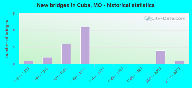
- New bridges - historical statistics
- 11930-1939
- 21940-1949
- 61950-1959
- 111960-1969
- 42000-2009
- 12010-2019

- Reconstructed bridges - Historical Statistics
- 21960-1969
- 01970-1979
- 11980-1989
- 11990-1999


- Bridge Condition - Deck
- 11.1%Excellent
- 11.1%Very good
- 22.2%Good
- 11.1%Satisfactory
- 22.2%Fair
- 22.2%Poor

- Bridge Condition - Superstructure
- 22.2%Very good
- 22.2%Good
- 11.1%Satisfactory
- 33.3%Fair
- 11.1%Poor

- Bridge Condition - Substructure
- 11.1%Excellent
- 22.2%Very good
- 22.2%Good
- 22.2%Satisfactory
- 11.1%Fair
- 11.1%Poor

- Bridge Condition - Channel
- 12.5%Good
- 75.0%Satisfactory
- 12.5%Fair

- Bridge Condition - Culverts
- 10.0%Good
- 90.0%Satisfactory
Find on map >> Show street view
Structure Number: 1149, Location: S 16 T 39 N R 4 W (Lat: 38.093575, Lng: -91.368481), Route carried "on" structure: State highway UU, Year Built: 1966, Year Reconstructed: 1987, Status: Open, Structure Length: 5.94m (19.49ft), Average Daily Traffic: 373 (year 2021), Truck Traffic: 15%, Average Future Daily Traffic: 522 (year 2041), Design Load: H 15, Features Intersected: IS 44
Minimum Vertical Clearance: 30+ m (98+ ft), Kilometerpoint: 7.150, Lanes on structure: 2, Lanes under structure: 4, Owner: State Highway Agency, Approaching Roadway Width: 6.1m (20.0ft), Skew: 20 degrees, Material/Design: Concrete continuous, Design/Construction: Slab, Number Of Spans In Main Unit: 4, Length of Maximum Span: 17.1m (56.1ft), Curb-To-Curb Width: 7.9m (25.9ft), Out-to-Out Width: 8.8m (28.9ft)
Condition: Deck: Fair, Superstructure: Fair, Substructure: Satisfactory, Operating Rating: 32.4 metric tons, Method Used To Determine Operating Rating: Allowable Stress (AS), Inventory Rating: 16.2 metric tons, Method Used To Determine Inventory Rating: Allowable Stress (AS), Structural Evaluation: Somewhat better than minimum adequacy, Deck Geometry: Somewhat better than minimum adequacy, Underclear: Meets minimum limits, Approach Roadway Alignment: Equal to present desirable criteria, Designated Inspection Frequency: Every 24 months, Inspection Date: September 2020, Deck Structure Type: Concrete Cast-file-Place, Wearing Surface/Protective System: Wearing Surface: Bituminous, Membrane: Built-up
Find on map >> Show street view
Structure Number: 12614, Location: S 2 T 39 N R 5 W (Lat: 38.141864, Lng: -91.441144), Route carried "on" structure: County highway 15, Year Built: 1948, Status: Open, Structure Length: 1.46m (4.79ft), Average Daily Traffic: 35 (year 2021), Truck Traffic: 10%, Average Future Daily Traffic: 42 (year 2041), Features Intersected: BRUSH CR, Facility Carried by Structure: 4 MILE RD
Minimum Vertical Clearance: 30+ m (98+ ft), Kilometerpoint: 4.989, Lanes on structure: 1, Owner: County Highway Agency, Approaching Roadway Width: 7.0m (23.0ft), Material/Design: Concrete, Design/Construction: Slab, Number Of Spans In Main Unit: 3, Length of Maximum Span: 4.9m (16.1ft), Curb-To-Curb Width: 4.2m (13.8ft), Out-to-Out Width: 4.2m (13.8ft)
Condition: Deck: Poor, Superstructure: Poor, Substructure: Fair, Channel: Satisfactory, Operating Rating: 49.5 metric tons, Method Used To Determine Operating Rating: Allowable Stress (AS), Inventory Rating: 16.2 metric tons, Method Used To Determine Inventory Rating: Allowable Stress (AS), Structural Evaluation: Meets minimum limits, Deck Geometry: Somewhat better than minimum adequacy, Waterway Adequacy: Meets minimum limits, Approach Roadway Alignment: Equal to present minimum criteria, Length Of Structure Improvement: 0.21m (0.69ft), Designated Inspection Frequency: Every 24 months, Inspection Date: Febuary 2021, Bridge Improvement Cost: $153,000, Roadway Improvement Cost: $15,000, Total Project Cost: $230,000 ( Estimate for 2022), Deck Structure Type: Concrete Cast-file-Place, Wearing Surface/Protective System: Wearing Surface: Monolithic Concrete
Find on map >> Show street view
Structure Number: 12616, Location: S 2 T 39 N R 5 W (Lat: 38.140469, Lng: -91.441147), Route carried "on" structure: County highway 15, Year Built: 1948, Status: Open, Structure Length: 1.46m (4.79ft), Average Daily Traffic: 35 (year 2021), Truck Traffic: 10%, Average Future Daily Traffic: 42 (year 2041), Features Intersected: PLEASANT VALLEY CR, Facility Carried by Structure: 4 MILE RD
Minimum Vertical Clearance: 30+ m (98+ ft), Kilometerpoint: 5.150, Lanes on structure: 1, Owner: County Highway Agency, Approaching Roadway Width: 7.0m (23.0ft), Material/Design: Concrete, Design/Construction: Slab, Number Of Spans In Main Unit: 3, Length of Maximum Span: 4.9m (16.1ft), Curb-To-Curb Width: 4.3m (14.1ft), Out-to-Out Width: 4.3m (14.1ft)
Condition: Deck: Poor, Superstructure: Fair, Substructure: Poor, Channel: Fair, Operating Rating: 49.5 metric tons, Method Used To Determine Operating Rating: Allowable Stress (AS), Inventory Rating: 16.2 metric tons, Method Used To Determine Inventory Rating: Allowable Stress (AS), Structural Evaluation: Meets minimum limits, Deck Geometry: Equal to present minimum criteria, Waterway Adequacy: Meets minimum limits, Approach Roadway Alignment: Somewhat better than minimum adequacy, Length Of Structure Improvement: 0.21m (0.69ft), Designated Inspection Frequency: Every 24 months, Inspection Date: Febuary 2021, Bridge Improvement Cost: $153,000, Roadway Improvement Cost: $15,000, Total Project Cost: $230,000 ( Estimate for 2022), Deck Structure Type: Concrete Cast-file-Place, Wearing Surface/Protective System: Wearing Surface: Monolithic Concrete
Find on map >> Show street view
Structure Number: 1642, Location: S 30 T 39 N R 4 W (Lat: 38.076900, Lng: -91.399989), Route carried "on" structure: State highway P, Year Built: 1966, Status: Open, Structure Length: 0.76m (2.49ft), Average Daily Traffic: 1,128 (year 2021), Truck Traffic: 16%, Average Future Daily Traffic: 1,579 (year 2041), Design Load: H 15, Features Intersected: PLEASANT VALLEY CR
Minimum Vertical Clearance: 30+ m (98+ ft), Kilometerpoint: 13.802, Lanes on structure: 2, Owner: State Highway Agency, Approaching Roadway Width: 8.5m (27.9ft), Material/Design: Concrete continuous, Design/Construction: Culvert, Number Of Spans In Main Unit: 2, Length of Maximum Span: 3.7m (12.1ft), Curb-To-Curb Width: 16.0m (52.5ft), Out-to-Out Width: 16.6m (54.5ft)
Condition: Channel: Good, Culverts: Satisfactory, Operating Rating: 97.2 metric tons, Method Used To Determine Operating Rating: Load Factor (LF), Inventory Rating: 58.5 metric tons, Method Used To Determine Inventory Rating: Load Factor (LF), Structural Evaluation: Equal to present minimum criteria, Deck Geometry: Superior to present desirable criteria, Waterway Adequacy: Equal to present desirable criteria, Approach Roadway Alignment: Equal to present desirable criteria, Designated Inspection Frequency: Every 24 months, Inspection Date: September 2020
Find on map >> Show street view
Structure Number: 1742, Location: S 34 T 39 N R 5 W (Lat: 38.050125, Lng: -91.458736), Route carried "on" structure: County highway , Year Built: 1966, Status: Open, Structure Length: 6.31m (20.70ft), Average Daily Traffic: 140 (year 2021), Truck Traffic: 10%, Average Future Daily Traffic: 196 (year 2041), Design Load: H 15, Features Intersected: IS 44, Facility Carried by Structure: BEAMER LN S
Minimum Vertical Clearance: 30+ m (98+ ft), Kilometerpoint: 1.276, Lanes on structure: 2, Lanes under structure: 4, Owner: State Highway Agency, Approaching Roadway Width: 7.9m (25.9ft), Material/Design: Concrete continuous, Design/Construction: Slab, Number Of Spans In Main Unit: 4, Length of Maximum Span: 17.1m (56.1ft), Curb-To-Curb Width: 7.9m (25.9ft), Out-to-Out Width: 8.8m (28.9ft)
Condition: Deck: Satisfactory, Superstructure: Satisfactory, Substructure: Good, Operating Rating: 43.2 metric tons, Method Used To Determine Operating Rating: Allowable Stress (AS), Inventory Rating: 21.6 metric tons, Method Used To Determine Inventory Rating: Allowable Stress (AS), Structural Evaluation: Equal to present minimum criteria, Deck Geometry: Somewhat better than minimum adequacy, Underclear: Meets minimum limits, Approach Roadway Alignment: Equal to present minimum criteria, Designated Inspection Frequency: Every 24 months, Inspection Date: September 2020, Deck Structure Type: Concrete Cast-file-Place, Wearing Surface/Protective System: Wearing Surface: Monolithic Concrete, Deck Protection: Internally Sealed
Find on map >> Show street view
Structure Number: 29734, Location: S 1 T 39 N R 5 W (Lat: 38.122378, Lng: -91.413003), Route carried "on" structure: County highway 29, Year Built: 2002, Status: Open, Structure Length: 0.63m (2.07ft), Average Daily Traffic: 700 (year 2021), Truck Traffic: 10%, Average Future Daily Traffic: 840 (year 2041), Features Intersected: BR OF BRUSH CR, Facility Carried by Structure: OAK HILL RD
Minimum Vertical Clearance: 30+ m (98+ ft), Kilometerpoint: 0.000, Lanes on structure: 2, Owner: County Highway Agency, Approaching Roadway Width: 6.4m (21.0ft), Material/Design: Steel continuous, Design/Construction: Culvert, Number Of Spans In Main Unit: 2, Length of Maximum Span: 2.6m (8.5ft), Curb-To-Curb Width: 8.8m (28.9ft), Out-to-Out Width: 8.8m (28.9ft)
Condition: Channel: Satisfactory, Culverts: Good, Structural Evaluation: Better than present minimum criteria, Deck Geometry: Somewhat better than minimum adequacy, Waterway Adequacy: Better than present minimum criteria, Approach Roadway Alignment: Equal to present desirable criteria, Designated Inspection Frequency: Every 24 months, Inspection Date: Febuary 2021
Find on map >> Show street view
Structure Number: 29735, Location: S 12 T 39 N R 5 W (Lat: 38.118569, Lng: -91.411928), Route carried "on" structure: County highway 29, Year Built: 2002, Status: Open, Structure Length: 1.01m (3.31ft), Average Daily Traffic: 700 (year 2021), Truck Traffic: 10%, Average Future Daily Traffic: 840 (year 2041), Design Load: HS 20, Features Intersected: BR OF BRUSH CR, Facility Carried by Structure: OAK HILL RD
Minimum Vertical Clearance: 30+ m (98+ ft), Kilometerpoint: 0.000, Lanes on structure: 2, Owner: County Highway Agency, Approaching Roadway Width: 6.4m (21.0ft), Material/Design: Concrete, Design/Construction: Box Beam or Girders - Multiple, Number Of Spans In Main Unit: 1, Length of Maximum Span: 8.8m (28.9ft), Curb-To-Curb Width: 7.4m (24.3ft), Out-to-Out Width: 7.8m (25.6ft)
Condition: Deck: Good, Superstructure: Good, Substructure: Good, Channel: Fair, Operating Rating: 63.9 metric tons, Method Used To Determine Operating Rating: Load Factor (LF), Inventory Rating: 38.7 metric tons, Method Used To Determine Inventory Rating: Load Factor (LF), Structural Evaluation: Better than present minimum criteria, Deck Geometry: Meets minimum limits, Waterway Adequacy: Better than present minimum criteria, Approach Roadway Alignment: Equal to present minimum criteria, Designated Inspection Frequency: Every 24 months, Inspection Date: Febuary 2021, Deck Structure Type: Concrete Precast Panels, Wearing Surface/Protective System: Wearing Surface: Bituminous
Find on map >> Show street view
Structure Number: 31234, Location: S 3 T 39 N R 5 W (Lat: 38.125769, Lng: -91.461656), Route carried "on" structure: County highway 23, Year Built: 2006, Status: Open, Structure Length: 3.20m (10.50ft), Average Daily Traffic: 50 (year 2021), Truck Traffic: 10%, Average Future Daily Traffic: 60 (year 2041), Design Load: HS 20, Features Intersected: BRUSH CR, Facility Carried by Structure: JAKE PRAIRIE RD
Minimum Vertical Clearance: 30+ m (98+ ft), Kilometerpoint: 0.644, Lanes on structure: 2, Owner: County Highway Agency, Approaching Roadway Width: 7.3m (24.0ft), Skew: 2 degrees, Material/Design: Prestressed concrete, Design/Construction: Stringer/Multi-beam, Number Of Spans In Main Unit: 1, Length of Maximum Span: 32.0m (105.0ft), Curb-To-Curb Width: 7.3m (24.0ft), Out-to-Out Width: 7.5m (24.6ft)
Condition: Deck: Very good, Superstructure: Very good, Substructure: Excellent, Channel: Satisfactory, Operating Rating: 84.6 metric tons, Method Used To Determine Operating Rating: Load Factor (LF), Inventory Rating: 45.9 metric tons, Method Used To Determine Inventory Rating: Load Factor (LF), Structural Evaluation: Equal to present desirable criteria, Deck Geometry: Equal to present minimum criteria, Waterway Adequacy: Better than present minimum criteria, Approach Roadway Alignment: Better than present minimum criteria, Designated Inspection Frequency: Every 24 months, Inspection Date: Febuary 2021, Deck Structure Type: Concrete Cast-file-Place, Wearing Surface/Protective System: Wearing Surface: Integral Concrete
Find on map >> Show street view
Structure Number: 33377, Location: S 2 T 39 N R 5 W (Lat: 38.122178, Lng: -91.441611), Route carried "on" structure: County highway 25, Year Built: 2008, Status: Open, Structure Length: 0.70m (2.30ft), Average Daily Traffic: 50 (year 2021), Truck Traffic: 10%, Average Future Daily Traffic: 60 (year 2041), Design Load: HS 20, Features Intersected: PLEASANT VALLEY CR, Facility Carried by Structure: EVANS RD
Minimum Vertical Clearance: 30+ m (98+ ft), Kilometerpoint: 0.966, Lanes on structure: 1, Owner: County Highway Agency, Approaching Roadway Width: 5.5m (18.0ft), Material/Design: Concrete, Design/Construction: Box Beam or Girders - Multiple, Number Of Spans In Main Unit: 1, Length of Maximum Span: 6.7m (22.0ft), Curb-To-Curb Width: 4.6m (15.1ft), Out-to-Out Width: 4.6m (15.1ft)
Condition: Deck: Good, Superstructure: Good, Substructure: Very good, Channel: Satisfactory, Operating Rating: 85.5 metric tons, Method Used To Determine Operating Rating: Load Factor (LF), Inventory Rating: 51.3 metric tons, Method Used To Determine Inventory Rating: Load Factor (LF), Structural Evaluation: Better than present minimum criteria, Deck Geometry: Better than present minimum criteria, Waterway Adequacy: Better than present minimum criteria, Approach Roadway Alignment: Equal to present desirable criteria, Designated Inspection Frequency: Every 24 months, Inspection Date: Febuary 2021, Deck Structure Type: Concrete Precast Panels, Wearing Surface/Protective System: Wearing Surface: Monolithic Concrete
Find on map >> Show street view
Structure Number: 34046, Location: S 18 T 38 N R 4 W (Lat: 38.012650, Lng: -91.414442), Route carried "on" structure: State highway O, Year Built: 2012, Status: Open, Structure Length: 3.67m (12.04ft), Average Daily Traffic: 275 (year 2021), Truck Traffic: 6%, Average Future Daily Traffic: 385 (year 2041), Design Load: HS 20, Features Intersected: PINE BR
Minimum Vertical Clearance: 30+ m (98+ ft), Kilometerpoint: 4.337, Lanes on structure: 2, Owner: State Highway Agency, Approaching Roadway Width: 7.3m (24.0ft), Skew: 1 degrees, Material/Design: Prestressed concrete, Design/Construction: Box Beam or Girders - Multiple, Number Of Spans In Main Unit: 3, Length of Maximum Span: 16.8m (55.1ft), Curb-To-Curb Width: 7.3m (24.0ft), Out-to-Out Width: 7.9m (25.9ft)
Condition: Deck: Excellent, Superstructure: Very good, Substructure: Very good, Channel: Satisfactory, Operating Rating: 60.3 metric tons, Method Used To Determine Operating Rating: Load Factor (LF), Inventory Rating: 36.0 metric tons, Method Used To Determine Inventory Rating: Load Factor (LF), Structural Evaluation: Equal to present desirable criteria, Deck Geometry: Somewhat better than minimum adequacy, Waterway Adequacy: Superior to present desirable criteria, Approach Roadway Alignment: Equal to present desirable criteria, Designated Inspection Frequency: Every 24 months, Inspection Date: September 2020, Deck Structure Type: Concrete Precast Panels, Wearing Surface/Protective System: Wearing Surface: Bituminous
Find on map >> Show street view
Structure Number: 544, Location: S 18 T 39 N R 4 W (Lat: 38.083283, Lng: -91.409594), Route carried "on" structure: State highway 19, Year Built: 1931, Status: Open, Structure Length: 0.64m (2.10ft), Average Daily Traffic: 3,087 (year 2021), Truck Traffic: 12%, Average Future Daily Traffic: 4,631 (year 2041), Design Load: H 15, Features Intersected: BR PLEASANT VALLEY
Minimum Vertical Clearance: 30+ m (98+ ft), Kilometerpoint: 196.556, Lanes on structure: 2, Base Highway Network: Yes, Owner: State Highway Agency, Approaching Roadway Width: 6.7m (22.0ft), Material/Design: Concrete continuous, Design/Construction: Culvert, Number Of Spans In Main Unit: 2, Length of Maximum Span: 3.7m (12.1ft), Curb-To-Curb Width: 10.3m (33.8ft), Out-to-Out Width: 10.9m (35.8ft)
Condition: Channel: Satisfactory, Culverts: Satisfactory, Operating Rating: 90.0 metric tons, Method Used To Determine Operating Rating: Load Factor (LF), Inventory Rating: 54.0 metric tons, Method Used To Determine Inventory Rating: Load Factor (LF), Structural Evaluation: Equal to present minimum criteria, Deck Geometry: Meets minimum limits, Waterway Adequacy: Equal to present desirable criteria, Approach Roadway Alignment: Equal to present desirable criteria, Designated Inspection Frequency: Every 24 months, Inspection Date: September 2020
Find on map >> Show street view
Structure Number: 6291, Location: S 35 T 39 N R 5 W (Lat: 38.055144, Lng: -91.445683), Route carried "on" structure: Interstate 44, Year Built: 1953, Year Reconstructed: 1966, Status: Open, Structure Length: 0.76m (2.49ft), Average Daily Traffic: 29,363 (year 2021), Truck Traffic: 35%, Average Future Daily Traffic: 55,790 (year 2041), Design Load: HS 20, Features Intersected: BR BRUSH CR
Minimum Vertical Clearance: 30+ m (98+ ft), Kilometerpoint: 331.200, Lanes on structure: 4, Base Highway Network: Yes, Owner: State Highway Agency, Approaching Roadway Width: 32.9m (107.9ft), Skew: 20 degrees, Material/Design: Concrete continuous, Design/Construction: Culvert, Number Of Spans In Main Unit: 2, Length of Maximum Span: 3.7m (12.1ft)
Condition: Channel: Satisfactory, Culverts: Satisfactory, Inventory Rating: 61.2 metric tons, Method Used To Determine Inventory Rating: Load Factor (LF), Structural Evaluation: Equal to present minimum criteria, Waterway Adequacy: Equal to present desirable criteria, Approach Roadway Alignment: Equal to present desirable criteria, Designated Inspection Frequency: Every 24 months, Inspection Date: September 2020
Find on map >> Show street view
Structure Number: 6292, Location: S 30 T 39 N R 4 W (Lat: 38.076664, Lng: -91.399444), Route carried "on" structure: Interstate 44, Year Built: 1953, Year Reconstructed: 1966, Status: Open, Structure Length: 0.76m (2.49ft), Average Daily Traffic: 26,996 (year 2021), Truck Traffic: 35%, Average Future Daily Traffic: 51,292 (year 2041), Design Load: HS 20, Features Intersected: PLEASANT VALLEY CR
Minimum Vertical Clearance: 30+ m (98+ ft), Kilometerpoint: 335.921, Lanes on structure: 4, Base Highway Network: Yes, Owner: State Highway Agency, Approaching Roadway Width: 32.9m (107.9ft), Skew: 20 degrees, Material/Design: Concrete continuous, Design/Construction: Culvert, Number Of Spans In Main Unit: 2, Length of Maximum Span: 3.7m (12.1ft)
Condition: Channel: Good, Culverts: Satisfactory, Operating Rating: 72.0 metric tons, Method Used To Determine Operating Rating: Field evaluation and documented engineering judgment, Inventory Rating: 43.2 metric tons, Method Used To Determine Inventory Rating: Field evaluation and documented engineering judgment, Structural Evaluation: Equal to present minimum criteria, Waterway Adequacy: Equal to present desirable criteria, Approach Roadway Alignment: Equal to present desirable criteria, Designated Inspection Frequency: Every 24 months, Inspection Date: September 2020
Find on map >> Show street view
Structure Number: 68, Location: S 33 T 39 N R 4 W (Lat: 38.052492, Lng: -91.356036), Route carried "on" structure: State highway PP, Year Built: 1958, Status: Open, Structure Length: 0.78m (2.56ft), Average Daily Traffic: 311 (year 2021), Truck Traffic: 4%, Average Future Daily Traffic: 435 (year 2041), Design Load: H 10, Features Intersected: BR OF LICK CR
Minimum Vertical Clearance: 30+ m (98+ ft), Kilometerpoint: 4.418, Lanes on structure: 2, Owner: State Highway Agency, Approaching Roadway Width: 7.3m (24.0ft), Skew: 1 degrees, Material/Design: Concrete continuous, Design/Construction: Culvert, Number Of Spans In Main Unit: 2, Length of Maximum Span: 3.7m (12.1ft), Curb-To-Curb Width: 7.9m (25.9ft), Out-to-Out Width: 8.5m (27.9ft)
Condition: Channel: Satisfactory, Culverts: Satisfactory, Operating Rating: 42.3 metric tons, Method Used To Determine Operating Rating: Load Factor (LF), Inventory Rating: 25.2 metric tons, Method Used To Determine Inventory Rating: Load Factor (LF), Structural Evaluation: Equal to present minimum criteria, Deck Geometry: Somewhat better than minimum adequacy, Waterway Adequacy: Equal to present minimum criteria, Approach Roadway Alignment: Equal to present desirable criteria, Designated Inspection Frequency: Every 24 months, Inspection Date: September 2020
Find on map >> Show street view
Structure Number: 6801, Location: S 34 T 39 N R 4 W (Lat: 38.052089, Lng: -91.344472), Route carried "on" structure: State highway PP, Year Built: 1958, Status: Open, Structure Length: 0.90m (2.95ft), Average Daily Traffic: 311 (year 2021), Truck Traffic: 4%, Average Future Daily Traffic: 435 (year 2041), Design Load: H 10, Features Intersected: BR OF LICK CR
Minimum Vertical Clearance: 30+ m (98+ ft), Kilometerpoint: 5.435, Lanes on structure: 2, Owner: State Highway Agency, Approaching Roadway Width: 7.3m (24.0ft), Skew: 4 degrees, Material/Design: Concrete continuous, Design/Construction: Culvert, Number Of Spans In Main Unit: 2, Length of Maximum Span: 3.4m (11.2ft), Curb-To-Curb Width: 8.5m (27.9ft), Out-to-Out Width: 9.1m (29.9ft)
Condition: Channel: Satisfactory, Culverts: Satisfactory, Operating Rating: 40.5 metric tons, Method Used To Determine Operating Rating: Load Factor (LF), Inventory Rating: 24.3 metric tons, Method Used To Determine Inventory Rating: Load Factor (LF), Structural Evaluation: Equal to present minimum criteria, Deck Geometry: Equal to present minimum criteria, Waterway Adequacy: Equal to present desirable criteria, Approach Roadway Alignment: Equal to present desirable criteria, Designated Inspection Frequency: Every 24 months, Inspection Date: September 2020
Find on map >> Show street view
Structure Number: 7628, Location: S 8 T 39 N R 4 W (Lat: 38.121875, Lng: -91.383836), Route carried "on" structure: State highway P, Year Built: 1953, Status: Open, Structure Length: 0.95m (3.12ft), Average Daily Traffic: 171 (year 2021), Truck Traffic: 3%, Average Future Daily Traffic: 239 (year 2041), Design Load: H 10, Features Intersected: LITTLE BRUSH CR
Minimum Vertical Clearance: 30+ m (98+ ft), Kilometerpoint: 8.180, Lanes on structure: 2, Owner: State Highway Agency, Approaching Roadway Width: 7.3m (24.0ft), Skew: 2 degrees, Material/Design: Concrete continuous, Design/Construction: Culvert, Number Of Spans In Main Unit: 3, Length of Maximum Span: 2.7m (8.9ft), Curb-To-Curb Width: 6.4m (21.0ft), Out-to-Out Width: 7.0m (23.0ft)
Condition: Channel: Satisfactory, Culverts: Satisfactory, Operating Rating: 46.8 metric tons, Method Used To Determine Operating Rating: Load Factor (LF), Inventory Rating: 27.9 metric tons, Method Used To Determine Inventory Rating: Load Factor (LF), Structural Evaluation: Equal to present minimum criteria, Deck Geometry: Meets minimum limits, Waterway Adequacy: Better than present minimum criteria, Approach Roadway Alignment: Equal to present desirable criteria, Designated Inspection Frequency: Every 24 months, Inspection Date: September 2020
Find on map >> Show street view
Structure Number: 7629, Location: S 17 T 39 N R 4 W (Lat: 38.098694, Lng: -91.391172), Route carried "on" structure: State highway P, Year Built: 1953, Status: Open, Structure Length: 1.16m (3.81ft), Average Daily Traffic: 1,128 (year 2021), Truck Traffic: 16%, Average Future Daily Traffic: 1,579 (year 2041), Design Load: H 10, Features Intersected: PRAIRIE CR
Minimum Vertical Clearance: 30+ m (98+ ft), Kilometerpoint: 11.013, Lanes on structure: 2, Owner: State Highway Agency, Approaching Roadway Width: 7.3m (24.0ft), Skew: 3 degrees, Material/Design: Concrete continuous, Design/Construction: Culvert, Number Of Spans In Main Unit: 3, Length of Maximum Span: 3.0m (9.8ft), Curb-To-Curb Width: 8.4m (27.6ft), Out-to-Out Width: 9.0m (29.5ft)
Condition: Channel: Satisfactory, Culverts: Satisfactory, Operating Rating: 54.0 metric tons, Method Used To Determine Operating Rating: Load Factor (LF), Inventory Rating: 32.4 metric tons, Method Used To Determine Inventory Rating: Load Factor (LF), Structural Evaluation: Equal to present minimum criteria, Deck Geometry: Meets minimum limits, Waterway Adequacy: Better than present minimum criteria, Approach Roadway Alignment: Better than present minimum criteria, Designated Inspection Frequency: Every 24 months, Inspection Date: September 2020
Find on map >> Show street view
Structure Number: 8407, Location: S 32 T 39 N R 5 W (Lat: 38.058967, Lng: -91.487181), Route carried "on" structure: State highway F, Year Built: 1964, Status: Open, Structure Length: 0.84m (2.76ft), Average Daily Traffic: 857 (year 2021), Truck Traffic: 12%, Average Future Daily Traffic: 1,200 (year 2041), Design Load: H 15, Features Intersected: BRUSH CR
Minimum Vertical Clearance: 30+ m (98+ ft), Kilometerpoint: 22.787, Lanes on structure: 2, Owner: State Highway Agency, Approaching Roadway Width: 7.3m (24.0ft), Skew: 1 degrees, Material/Design: Concrete continuous, Design/Construction: Culvert, Number Of Spans In Main Unit: 2, Length of Maximum Span: 4.0m (13.1ft), Curb-To-Curb Width: 10.8m (35.4ft), Out-to-Out Width: 11.4m (37.4ft)
Condition: Channel: Satisfactory, Culverts: Satisfactory, Operating Rating: 75.6 metric tons, Method Used To Determine Operating Rating: Load Factor (LF), Inventory Rating: 45.0 metric tons, Method Used To Determine Inventory Rating: Load Factor (LF), Structural Evaluation: Equal to present minimum criteria, Deck Geometry: Equal to present minimum criteria, Waterway Adequacy: Equal to present desirable criteria, Approach Roadway Alignment: Equal to present desirable criteria, Designated Inspection Frequency: Every 24 months, Inspection Date: September 2020
Find on map >> Show street view
Structure Number: 981, Location: S 30 T 39 N R 4 W (Lat: 38.073031, Lng: -91.406236), Route carried "on" structure: State highway 19, Year Built: 1966, Year Reconstructed: 1999, Status: Open, Structure Length: 5.94m (19.49ft), Average Daily Traffic: 10,290 (year 2021), Truck Traffic: 10%, Average Future Daily Traffic: 15,435 (year 2041), Design Load: HS 20, Features Intersected: IS 44
Minimum Vertical Clearance: 30+ m (98+ ft), Kilometerpoint: 197.742, Lanes on structure: 6, Lanes under structure: 4, Base Highway Network: Yes, Owner: State Highway Agency, Approaching Roadway Width: 27.4m (89.9ft), Skew: 20 degrees, Material/Design: Concrete continuous, Design/Construction: Slab, Number Of Spans In Main Unit: 4, Length of Maximum Span: 17.1m (56.1ft), Curb-To-Curb Width: 27.4m (89.9ft), Out-to-Out Width: 28.3m (92.8ft)
Condition: Deck: Fair, Superstructure: Fair, Substructure: Satisfactory, Operating Rating: 50.4 metric tons, Method Used To Determine Operating Rating: Load Factor (LF), Inventory Rating: 30.6 metric tons, Method Used To Determine Inventory Rating: Load Factor (LF), Structural Evaluation: Somewhat better than minimum adequacy, Deck Geometry: Better than present minimum criteria, Underclear: Meets minimum limits, Approach Roadway Alignment: Equal to present desirable criteria, Designated Inspection Frequency: Every 24 months, Inspection Date: September 2020, Deck Structure Type: Concrete Cast-file-Place, Wearing Surface/Protective System: Wearing Surface: Low Slump Concrete, Deck Protection: Internally Sealed
Find on map >> Show street view
Structure Number: 1149, Location: S 16 T 39 N R 4 W (Lat: 38.093575, Lng: -91.368481), Route carried "under" structure: Interstate 44, Year Built: 1966, Structure Length: 0. m, Average Daily Traffic: 13,733 (year 2021), Truck Traffic: 35%, Features Intersected: IS 44, Facility Carried by Structure: RT UU S
Minimum Vertical Clearance: 4.98m (16.34ft), Kilometerpoint: 339.225, Lanes on structure: 2, Lanes under structure: 2, Material/Design: Concrete continuous, Design/Construction: Slab, Length of Maximum Span: 17.1m (56.1ft)
Find on map >> Show street view
Structure Number: 1149, Location: S 16 T 39 N R 4 W (Lat: 38.093575, Lng: -91.368481), Route carried "under" structure: Interstate 44, Year Built: 1966, Structure Length: 0. m, Average Daily Traffic: 12,978 (year 2021), Truck Traffic: 35%, Features Intersected: IS 44, Facility Carried by Structure: RT UU S
Minimum Vertical Clearance: 4.88m (16.01ft), Kilometerpoint: 132.544, Lanes on structure: 2, Lanes under structure: 2, Material/Design: Concrete continuous, Design/Construction: Slab, Length of Maximum Span: 17.1m (56.1ft)
Find on map >> Show street view
Structure Number: 1742, Location: S 34 T 39 N R 5 W (Lat: 38.050125, Lng: -91.458736), Route carried "under" structure: Interstate 44, Year Built: 1966, Structure Length: 0. m, Average Daily Traffic: 14,315 (year 2021), Truck Traffic: 35%, Features Intersected: IS 44, Facility Carried by Structure: BEAMER LN S
Minimum Vertical Clearance: 5.23m (17.16ft), Kilometerpoint: 329.931, Lanes on structure: 2, Lanes under structure: 2, Material/Design: Concrete continuous, Design/Construction: Slab, Length of Maximum Span: 17.1m (56.1ft)
Find on map >> Show street view
Structure Number: 1742, Location: S 34 T 39 N R 5 W (Lat: 38.050125, Lng: -91.458736), Route carried "under" structure: Interstate 44, Year Built: 1966, Structure Length: 0. m, Average Daily Traffic: 15,048 (year 2021), Truck Traffic: 35%, Features Intersected: IS 44, Facility Carried by Structure: BEAMER LN S
Minimum Vertical Clearance: 4.88m (16.01ft), Kilometerpoint: 141.833, Lanes on structure: 2, Lanes under structure: 2, Material/Design: Concrete continuous, Design/Construction: Slab, Length of Maximum Span: 17.1m (56.1ft)
Find on map >> Show street view
Structure Number: 981, Location: S 30 T 39 N R 4 W (Lat: 38.073031, Lng: -91.406236), Route carried "under" structure: Interstate 44, Year Built: 1966, Structure Length: 0. m, Average Daily Traffic: 14,315 (year 2021), Truck Traffic: 35%, Features Intersected: IS 44, Facility Carried by Structure: MO 19 S
Minimum Vertical Clearance: 4.98m (16.34ft), Kilometerpoint: 335.204, Lanes on structure: 6, Lanes under structure: 2, Material/Design: Concrete continuous, Design/Construction: Slab, Length of Maximum Span: 17.1m (56.1ft)
Find on map >> Show street view
Structure Number: 981, Location: S 30 T 39 N R 4 W (Lat: 38.073031, Lng: -91.406236), Route carried "under" structure: Interstate 44, Year Built: 1966, Structure Length: 0. m, Average Daily Traffic: 13,263 (year 2021), Truck Traffic: 35%, Features Intersected: IS 44, Facility Carried by Structure: MO 19 S
Minimum Vertical Clearance: 4.90m (16.08ft), Kilometerpoint: 136.564, Lanes on structure: 6, Lanes under structure: 2, Material/Design: Concrete continuous, Design/Construction: Slab, Length of Maximum Span: 17.1m (56.1ft)