Bridge Statistics for Cumberland City, Tennessee (TN)
Condition, Traffic, Stress, Structural Evaluation, Project Costs
- National Bridge Inventory (NBI) Statistics
- 33Number of bridges
- 302ft / 91.8mTotal length
- $1,748,000Total costs
- 53,601Total average daily traffic
- 3,022Total average daily truck traffic
- National Bridge Inventory (NBI) Registered Bridges for Cumberland City
- No street view available for this location
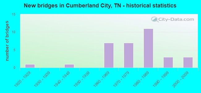
- New bridges - historical statistics
- 11920-1929
- 11940-1949
- 71960-1969
- 71970-1979
- 111980-1989
- 31990-1999
- 32000-2009

- Reconstructed bridges - Historical Statistics
- 11970-1979
- 11980-1989
- 31990-1999


- Bridge Condition - Deck
- 26.7%Very good
- 26.7%Good
- 33.3%Satisfactory
- 13.3%Fair

- Bridge Condition - Superstructure
- 13.3%Very good
- 13.3%Good
- 60.0%Satisfactory
- 13.3%Fair

- Bridge Condition - Substructure
- 13.3%Very good
- 20.0%Good
- 40.0%Satisfactory
- 20.0%Fair
- 6.7%Poor

- Bridge Condition - Channel
- 16.1%Very good
- 29.0%Good
- 35.5%Satisfactory
- 6.5%Fair
- 12.9%Poor

- Bridge Condition - Culverts
- 43.8%Good
- 50.0%Satisfactory
- 6.3%Fair
Find on map >> Show street view
Structure Number: 42017870003, Location: 1.5 M N JCT SR13&SR46 (Lat: 36.357267, Lng: -87.609800), Route carried "on" structure: State highway 46, Year Built: 1975, Status: Open, Structure Length: 2.53m (8.30ft), Average Daily Traffic: 793 (year 2020), Truck Traffic: 4%, Average Future Daily Traffic: 1,269 (year 2042), Design Load: H 15, Features Intersected: GUICES CREEK
Minimum Vertical Clearance: 30+ m (98+ ft), Kilometerpoint: 10.799, Lanes on structure: 2, Owner: State Highway Agency, Approaching Roadway Width: 7.9m (25.9ft), Skew: 3 degrees, Material/Design: Concrete, Design/Construction: Tee Beam, Number Of Spans In Main Unit: 3, Length of Maximum Span: 8.5m (27.9ft), Curb-To-Curb Width: 8.5m (27.9ft), Out-to-Out Width: 9.1m (29.9ft)
Condition: Deck: Satisfactory, Superstructure: Fair, Substructure: Fair, Channel: Satisfactory, Operating Rating: 36.0 metric tons, Method Used To Determine Operating Rating: Field evaluation and documented engineering judgment, Inventory Rating: 24.3 metric tons, Method Used To Determine Inventory Rating: Field evaluation and documented engineering judgment, Structural Evaluation: Somewhat better than minimum adequacy, Deck Geometry: Somewhat better than minimum adequacy, Waterway Adequacy: Equal to present minimum criteria, Approach Roadway Alignment: Equal to present minimum criteria, Length Of Structure Improvement: 2.53m (8.30ft), Designated Inspection Frequency: Every 24 months, Inspection Date: December 2021, Bridge Improvement Cost: $390,000, Roadway Improvement Cost: $40,000, Total Project Cost: $586,000 ( Estimate for 2022), Deck Structure Type: Concrete Cast-file-Place, Wearing Surface/Protective System: Wearing Surface: Monolithic Concrete
Find on map >> Show street view
Structure Number: 420A0340001, Location: 3.5 M. NE. ERIN. (Lat: 36.368000, Lng: -87.678167), Route carried "on" structure: County highway 455, Year Built: 1983, Status: Open, Structure Length: 2.10m (6.89ft), Average Daily Traffic: 160 (year 2022), Truck Traffic: 2%, Average Future Daily Traffic: 256 (year 2042), Design Load: HS 20, Features Intersected: BOOSTER BRANCH
Minimum Vertical Clearance: 30+ m (98+ ft), Kilometerpoint: 0.008, Lanes on structure: 2, Owner: County Highway Agency, Approaching Roadway Width: 6.1m (20.0ft), Skew: 4 degrees, Material/Design: Concrete continuous, Design/Construction: Culvert, Number Of Spans In Main Unit: 3, Length of Maximum Span: 4.6m (15.1ft), Curb-To-Curb Width: 6.6m (21.7ft), Out-to-Out Width: 8.0m (26.2ft)
Condition: Channel: Satisfactory, Culverts: Satisfactory, Operating Rating: 48.6 metric tons, Method Used To Determine Operating Rating: Load Factor (LF), Inventory Rating: 28.8 metric tons, Method Used To Determine Inventory Rating: Load Factor (LF), Structural Evaluation: Equal to present minimum criteria, Deck Geometry: Meets minimum limits, Waterway Adequacy: Equal to present minimum criteria, Approach Roadway Alignment: Equal to present minimum criteria, Designated Inspection Frequency: Every 24 months, Inspection Date: January 2022, Deck Structure Type: Concrete Cast-file-Place, Wearing Surface/Protective System: Wearing Surface: Monolithic Concrete
Find on map >> Show street view
Structure Number: 420A0340003, Location: 3 M. NE. ERIN. (Lat: 36.354550, Lng: -87.665233), Route carried "on" structure: County highway 455, Year Built: 1988, Status: Open, Structure Length: 5.18m (16.99ft), Average Daily Traffic: 160 (year 2022), Truck Traffic: 2%, Average Future Daily Traffic: 256 (year 2040), Design Load: HS 20, Features Intersected: WELLS CREEK
Minimum Vertical Clearance: 30+ m (98+ ft), Kilometerpoint: 2.171, Lanes on structure: 2, Owner: County Highway Agency, Approaching Roadway Width: 8.5m (27.9ft), Material/Design: Prestressed concrete continuous, Design/Construction: Stringer/Multi-beam, Number Of Spans In Main Unit: 3, Length of Maximum Span: 17.1m (56.1ft), Curb-To-Curb Width: 6.7m (22.0ft), Out-to-Out Width: 7.4m (24.3ft)
Condition: Deck: Very good, Superstructure: Very good, Substructure: Very good, Channel: Poor, Operating Rating: 56.3 metric tons, Method Used To Determine Operating Rating: Load Factor (LF), Inventory Rating: 31.8 metric tons, Method Used To Determine Inventory Rating: Load Factor (LF), Structural Evaluation: Better than present minimum criteria, Deck Geometry: Meets minimum limits, Waterway Adequacy: Better than present minimum criteria, Approach Roadway Alignment: Equal to present minimum criteria, Designated Inspection Frequency: Every 24 months, Inspection Date: January 2022, Deck Structure Type: Concrete Cast-file-Place, Wearing Surface/Protective System: Wearing Surface: Monolithic Concrete
Find on map >> Show street view
Structure Number: 420A0480003, Location: 5 M. NE. ERIN. (Lat: 36.347283, Lng: -87.607033), Route carried "on" structure: County highway 48, Year Built: 1975, Status: Open, Structure Length: 1.98m (6.50ft), Average Daily Traffic: 20 (year 2022), Truck Traffic: 2%, Average Future Daily Traffic: 32 (year 2042), Design Load: HS 20, Features Intersected: GUICES CREEK
Minimum Vertical Clearance: 30+ m (98+ ft), Kilometerpoint: 0.048, Lanes on structure: 2, Owner: County Highway Agency, Approaching Roadway Width: 4.9m (16.1ft), Material/Design: Prestressed concrete continuous, Design/Construction: Stringer/Multi-beam, Number Of Spans In Main Unit: 2, Length of Maximum Span: 9.1m (29.9ft), Curb-To-Curb Width: 6.4m (21.0ft), Out-to-Out Width: 7.3m (24.0ft)
Condition: Deck: Good, Superstructure: Satisfactory, Substructure: Fair, Channel: Poor, Operating Rating: 44.1 metric tons, Method Used To Determine Operating Rating: Assigned rating based on Load Factor Design (LFD) reported in metric tons, Inventory Rating: 32.4 metric tons, Method Used To Determine Inventory Rating: Assigned rating based on Load Factor Design (LFD) reported in metric tons, Structural Evaluation: Somewhat better than minimum adequacy, Deck Geometry: Somewhat better than minimum adequacy, Waterway Adequacy: Meets minimum limits, Approach Roadway Alignment: Equal to present desirable criteria, Designated Inspection Frequency: Every 24 months, Inspection Date: January 2022, Deck Structure Type: Concrete Cast-file-Place, Wearing Surface/Protective System: Wearing Surface: Bituminous
Find on map >> Show street view
Structure Number: 420A0650001, Location: 6 M. NE. ERIN. (Lat: 36.357833, Lng: -87.601017), Route carried "on" structure: County highway 65, Year Built: 1984, Status: Open, Structure Length: 1.43m (4.69ft), Average Daily Traffic: 90 (year 2022), Truck Traffic: 2%, Average Future Daily Traffic: 144 (year 2042), Design Load: HS 20, Features Intersected: MOORE BRANCH
Minimum Vertical Clearance: 30+ m (98+ ft), Kilometerpoint: 0.505, Lanes on structure: 2, Owner: County Highway Agency, Approaching Roadway Width: 5.5m (18.0ft), Skew: 4 degrees, Material/Design: Concrete continuous, Design/Construction: Culvert, Number Of Spans In Main Unit: 2, Length of Maximum Span: 4.6m (15.1ft), Curb-To-Curb Width: 6.6m (21.7ft), Out-to-Out Width: 7.7m (25.3ft)
Condition: Channel: Satisfactory, Culverts: Satisfactory, Operating Rating: 48.6 metric tons, Method Used To Determine Operating Rating: Load Factor (LF), Inventory Rating: 28.8 metric tons, Method Used To Determine Inventory Rating: Load Factor (LF), Structural Evaluation: Equal to present minimum criteria, Deck Geometry: Somewhat better than minimum adequacy, Waterway Adequacy: Equal to present minimum criteria, Approach Roadway Alignment: Equal to present minimum criteria, Designated Inspection Frequency: Every 24 months, Inspection Date: January 2022, Deck Structure Type: Concrete Cast-file-Place, Wearing Surface/Protective System: Wearing Surface: Monolithic Concrete
Find on map >> Show street view
Structure Number: 420A1100003, Location: 5.5 M. E. ERIN. (Lat: 36.314433, Lng: -87.601017), Route carried "on" structure: County highway 110, Year Built: 1995, Status: Open, Structure Length: 0.91m (2.99ft), Average Daily Traffic: 80 (year 2022), Truck Traffic: 2%, Average Future Daily Traffic: 128 (year 2040), Design Load: HS 20, Features Intersected: GUICES CREEK
Minimum Vertical Clearance: 30+ m (98+ ft), Kilometerpoint: 0.166, Lanes on structure: 2, Owner: County Highway Agency, Approaching Roadway Width: 4.6m (15.1ft), Skew: 3 degrees, Material/Design: Concrete continuous, Design/Construction: Culvert, Number Of Spans In Main Unit: 2, Length of Maximum Span: 3.7m (12.1ft), Curb-To-Curb Width: 6.7m (22.0ft), Out-to-Out Width: 8.4m (27.6ft)
Condition: Channel: Satisfactory, Culverts: Good, Operating Rating: 68.4 metric tons, Method Used To Determine Operating Rating: Load Factor (LF), Inventory Rating: 42.3 metric tons, Method Used To Determine Inventory Rating: Load Factor (LF), Structural Evaluation: Better than present minimum criteria, Deck Geometry: Somewhat better than minimum adequacy, Waterway Adequacy: Equal to present minimum criteria, Approach Roadway Alignment: Equal to present desirable criteria, Designated Inspection Frequency: Every 24 months, Inspection Date: January 2022, Deck Structure Type: Concrete Cast-file-Place, Wearing Surface/Protective System: Wearing Surface: Monolithic Concrete, Deck Protection: Epoxy Coated Reinforcing
Find on map >> Show street view
Structure Number: 420A2530001, Location: 3.3 M N OF ERIN (Lat: 36.365800, Lng: -87.682867), Route carried "on" structure: County highway 253, Year Built: 1987, Status: Open, Structure Length: 1.13m (3.71ft), Average Daily Traffic: 110 (year 2022), Truck Traffic: 2%, Average Future Daily Traffic: 176 (year 2042), Design Load: HS 20, Features Intersected: BOOSTER BRANCH
Minimum Vertical Clearance: 30+ m (98+ ft), Kilometerpoint: 0.568, Lanes on structure: 2, Owner: County Highway Agency, Approaching Roadway Width: 5.5m (18.0ft), Skew: 4 degrees, Material/Design: Concrete continuous, Design/Construction: Culvert, Number Of Spans In Main Unit: 2, Length of Maximum Span: 3.7m (12.1ft), Curb-To-Curb Width: 6.7m (22.0ft), Out-to-Out Width: 7.8m (25.6ft)
Condition: Channel: Good, Culverts: Good, Operating Rating: 58.5 metric tons, Method Used To Determine Operating Rating: Load Factor (LF), Inventory Rating: 36.0 metric tons, Method Used To Determine Inventory Rating: Load Factor (LF), Structural Evaluation: Better than present minimum criteria, Deck Geometry: Meets minimum limits, Waterway Adequacy: Equal to present minimum criteria, Approach Roadway Alignment: Equal to present minimum criteria, Designated Inspection Frequency: Every 24 months, Inspection Date: January 2022, Deck Structure Type: Concrete Cast-file-Place, Wearing Surface/Protective System: Wearing Surface: Monolithic Concrete
Find on map >> Show street view
Structure Number: 42S61440001, Location: .2 M S JCT SR13&SR46 (Lat: 36.334867, Lng: -87.604467), Route carried "on" structure: State highway 46, Year Built: 1964, Status: Open, Structure Length: 2.87m (9.42ft), Average Daily Traffic: 507 (year 2020), Truck Traffic: 6%, Average Future Daily Traffic: 811 (year 2041), Design Load: H 15, Features Intersected: GUICES CREEK
Minimum Vertical Clearance: 30+ m (98+ ft), Kilometerpoint: 8.095, Lanes on structure: 2, Owner: State Highway Agency, Approaching Roadway Width: 7.9m (25.9ft), Skew: 3 degrees, Material/Design: Prestressed concrete, Design/Construction: Stringer/Multi-beam, Number Of Spans In Main Unit: 3, Length of Maximum Span: 9.1m (29.9ft), Curb-To-Curb Width: 7.3m (24.0ft), Out-to-Out Width: 8.7m (28.5ft)
Condition: Deck: Satisfactory, Superstructure: Satisfactory, Substructure: Poor, Channel: Fair, Operating Rating: 35.1 metric tons, Method Used To Determine Operating Rating: Load Factor (LF), Inventory Rating: 24.3 metric tons, Method Used To Determine Inventory Rating: Load Factor (LF), Structural Evaluation: Meets minimum limits, Deck Geometry: Meets minimum limits, Waterway Adequacy: Equal to present minimum criteria, Approach Roadway Alignment: Equal to present desirable criteria, Length Of Structure Improvement: 2.87m (9.42ft), Designated Inspection Frequency: Every 24 months, Other Special Inspection Frequency: Every 12 months, Inspection Date: December 2021, Other Special Inspection Date: December 2021, Bridge Improvement Cost: $110,000, Roadway Improvement Cost: $12,000, Total Project Cost: $166,000 ( Estimate for 2021), Deck Structure Type: Concrete Cast-file-Place, Wearing Surface/Protective System: Wearing Surface: Bituminous
Find on map >> Show street view
Structure Number: 42SR0130009, Location: 4.7 MI.NORTHEAST OF ERIN (Lat: 36.337000, Lng: -87.609083), Route carried "on" structure: State highway 13, Year Built: 1928, Year Reconstructed: 1978, Status: Open, Structure Length: 1.43m (4.69ft), Average Daily Traffic: 1,599 (year 2020), Truck Traffic: 5%, Average Future Daily Traffic: 2,558 (year 2042), Design Load: HS 20, Features Intersected: BRANCH
Minimum Vertical Clearance: 30+ m (98+ ft), Kilometerpoint: 17.647, Lanes on structure: 2, Owner: State Highway Agency, Approaching Roadway Width: 10.4m (34.1ft), Skew: 4 degrees, Material/Design: Concrete continuous, Design/Construction: Culvert, Number Of Spans In Main Unit: 3, Length of Maximum Span: 2.4m (7.9ft), Curb-To-Curb Width: 11.8m (38.7ft), Out-to-Out Width: 12.9m (42.3ft)
Condition: Channel: Fair, Culverts: Good, Operating Rating: 42.3 metric tons, Method Used To Determine Operating Rating: Load Factor (LF), Inventory Rating: 26.1 metric tons, Method Used To Determine Inventory Rating: Load Factor (LF), Structural Evaluation: Equal to present minimum criteria, Deck Geometry: Equal to present minimum criteria, Waterway Adequacy: Somewhat better than minimum adequacy, Approach Roadway Alignment: Equal to present desirable criteria, Designated Inspection Frequency: Every 24 months, Inspection Date: December 2021, Deck Structure Type: Concrete Cast-file-Place, Wearing Surface/Protective System: Wearing Surface: Bituminous
Find on map >> Show street view
Structure Number: 42SR0130011, Location: 4.85 MI.NORTHEAST OF ERIN (Lat: 36.337967, Lng: -87.606483), Route carried "on" structure: State highway 13, Year Built: 1978, Status: Open, Structure Length: 1.46m (4.79ft), Average Daily Traffic: 1,599 (year 2020), Truck Traffic: 5%, Average Future Daily Traffic: 2,558 (year 2042), Design Load: HS 20, Features Intersected: GRICES CREEK
Minimum Vertical Clearance: 30+ m (98+ ft), Kilometerpoint: 17.896, Lanes on structure: 2, Owner: State Highway Agency, Approaching Roadway Width: 10.4m (34.1ft), Material/Design: Concrete continuous, Design/Construction: Culvert, Number Of Spans In Main Unit: 3, Length of Maximum Span: 4.6m (15.1ft), Curb-To-Curb Width: 11.6m (38.1ft), Out-to-Out Width: 12.9m (42.3ft)
Condition: Channel: Satisfactory, Culverts: Satisfactory, Operating Rating: 71.1 metric tons, Method Used To Determine Operating Rating: Load Factor (LF), Inventory Rating: 42.3 metric tons, Method Used To Determine Inventory Rating: Load Factor (LF), Structural Evaluation: Equal to present minimum criteria, Deck Geometry: Equal to present minimum criteria, Waterway Adequacy: Equal to present minimum criteria, Approach Roadway Alignment: Equal to present desirable criteria, Designated Inspection Frequency: Every 24 months, Inspection Date: December 2021, Deck Structure Type: Concrete Cast-file-Place, Wearing Surface/Protective System: Wearing Surface: Bituminous
Find on map >> Show street view
Structure Number: 42SR1490001, Location: 1.96 MILE NORTH OF ERIN (Lat: 36.346667, Lng: -87.666667), Route carried "on" structure: State highway 149, Year Built: 1980, Status: Open, Structure Length: 4.39m (14.40ft), Average Daily Traffic: 5,564 (year 2020), Truck Traffic: 7%, Average Future Daily Traffic: 8,902 (year 2042), Design Load: HS 20, Features Intersected: WELLS CREEK
Minimum Vertical Clearance: 30+ m (98+ ft), Kilometerpoint: 3.380, Lanes on structure: 2, Base Highway Network: Yes, Owner: State Highway Agency, Approaching Roadway Width: 12.2m (40.0ft), Skew: 3 degrees, Material/Design: Prestressed concrete continuous, Design/Construction: Box Beam or Girders - Single/Spread, Number Of Spans In Main Unit: 3, Length of Maximum Span: 11.0m (36.1ft), Curb-To-Curb Width: 13.4m (44.0ft), Out-to-Out Width: 14.0m (45.9ft)
Condition: Deck: Very good, Superstructure: Very good, Substructure: Good, Channel: Good, Operating Rating: 43.2 metric tons, Method Used To Determine Operating Rating: Load Factor (LF), Inventory Rating: 32.4 metric tons, Method Used To Determine Inventory Rating: Load Factor (LF), Structural Evaluation: Better than present minimum criteria, Deck Geometry: Equal to present minimum criteria, Waterway Adequacy: Equal to present desirable criteria, Approach Roadway Alignment: Equal to present desirable criteria, Designated Inspection Frequency: Every 24 months, Inspection Date: December 2021, Deck Structure Type: Concrete Precast Panels, Wearing Surface/Protective System: Wearing Surface: Bituminous
Find on map >> Show street view
Structure Number: 42SR1490011, Location: 2 M S STEWART CO LINE (Lat: 36.350117, Lng: -87.666100), Route carried "on" structure: State highway 149, Year Built: 1992, Status: Open, Structure Length: 1.01m (3.31ft), Average Daily Traffic: 5,564 (year 2020), Truck Traffic: 7%, Average Future Daily Traffic: 8,902 (year 2042), Design Load: HS 20, Features Intersected: CAVE BRANCH
Minimum Vertical Clearance: 30+ m (98+ ft), Kilometerpoint: 3.637, Lanes on structure: 4, Base Highway Network: Yes, Owner: State Highway Agency, Approaching Roadway Width: 29.3m (96.1ft), Material/Design: Concrete continuous, Design/Construction: Culvert, Number Of Spans In Main Unit: 3, Length of Maximum Span: 3.0m (9.8ft)
Condition: Channel: Satisfactory, Culverts: Satisfactory, Operating Rating: 89.1 metric tons, Method Used To Determine Operating Rating: Load Factor (LF), Inventory Rating: 70.2 metric tons, Method Used To Determine Inventory Rating: Load Factor (LF), Structural Evaluation: Equal to present minimum criteria, Waterway Adequacy: Equal to present minimum criteria, Approach Roadway Alignment: Equal to present desirable criteria, Length Of Structure Improvement: 1.01m (3.31ft), Designated Inspection Frequency: Every 24 months, Inspection Date: December 2021, Bridge Improvement Cost: $297,000, Roadway Improvement Cost: $30,000, Total Project Cost: $446,000 ( Estimate for 2022)
Find on map >> Show street view
Structure Number: 42SR1490013, Location: .5 M S STEWART CO LINE (Lat: 36.362167, Lng: -87.653617), Route carried "on" structure: State highway 149, Year Built: 1992, Status: Open, Structure Length: 1.19m (3.90ft), Average Daily Traffic: 5,564 (year 2020), Truck Traffic: 7%, Average Future Daily Traffic: 10,688 (year 2039), Design Load: HS 20, Features Intersected: LICKSKILLET BRANCH
Minimum Vertical Clearance: 30+ m (98+ ft), Kilometerpoint: 5.440, Lanes on structure: 2, Base Highway Network: Yes, Owner: State Highway Agency, Approaching Roadway Width: 10.4m (34.1ft), Material/Design: Concrete continuous, Design/Construction: Culvert, Number Of Spans In Main Unit: 3, Length of Maximum Span: 3.7m (12.1ft)
Condition: Channel: Good, Culverts: Good, Operating Rating: 89.1 metric tons, Method Used To Determine Operating Rating: Load Factor (LF), Inventory Rating: 32.4 metric tons, Method Used To Determine Inventory Rating: Load Factor (LF), Structural Evaluation: Better than present minimum criteria, Waterway Adequacy: Better than present minimum criteria, Approach Roadway Alignment: Equal to present desirable criteria, Designated Inspection Frequency: Every 24 months, Inspection Date: December 2021
Find on map >> Show street view
Structure Number: 630A2190001, Location: 6 M. W. PALMYRA (Lat: 36.422833, Lng: -87.587733), Route carried "on" structure: County highway 238, Year Built: 1986, Status: Open, Structure Length: 3.63m (11.91ft), Average Daily Traffic: 70 (year 2022), Truck Traffic: 2%, Average Future Daily Traffic: 112 (year 2041), Design Load: HS 20, Features Intersected: MARSHALL CREEK
Minimum Vertical Clearance: 30+ m (98+ ft), Kilometerpoint: 1.326, Lanes on structure: 2, Owner: County Highway Agency, Approaching Roadway Width: 7.0m (23.0ft), Skew: 1 degrees, Material/Design: Prestressed concrete continuous, Design/Construction: Stringer/Multi-beam, Number Of Spans In Main Unit: 3, Length of Maximum Span: 11.9m (39.0ft), Curb-To-Curb Width: 7.3m (24.0ft), Out-to-Out Width: 7.9m (25.9ft)
Condition: Deck: Very good, Superstructure: Good, Substructure: Very good, Channel: Good, Operating Rating: 58.0 metric tons, Method Used To Determine Operating Rating: Load Factor (LF), Inventory Rating: 32.4 metric tons, Method Used To Determine Inventory Rating: Load Factor (LF), Structural Evaluation: Better than present minimum criteria, Deck Geometry: Equal to present minimum criteria, Waterway Adequacy: Equal to present desirable criteria, Approach Roadway Alignment: Equal to present minimum criteria, Designated Inspection Frequency: Every 24 months, Inspection Date: December 2020, Deck Structure Type: Concrete Cast-file-Place, Wearing Surface/Protective System: Wearing Surface: Monolithic Concrete, Deck Protection: Epoxy Coated Reinforcing
Find on map >> Show street view
Structure Number: 63SR1490001, Location: 1.53MI E.OF STEWART CO.LI (Lat: 36.414600, Lng: -87.579933), Route carried "on" structure: State highway 149, Year Built: 1979, Status: Open, Structure Length: 7.86m (25.79ft), Average Daily Traffic: 5,357 (year 2020), Truck Traffic: 7%, Average Future Daily Traffic: 8,960 (year 2040), Design Load: HS 20, Features Intersected: YELLOW CREEK
Minimum Vertical Clearance: 30+ m (98+ ft), Kilometerpoint: 2.462, Lanes on structure: 2, Base Highway Network: Yes, Owner: State Highway Agency, Approaching Roadway Width: 14.6m (47.9ft), Material/Design: Prestressed concrete continuous, Design/Construction: Stringer/Multi-beam, Number Of Spans In Main Unit: 5, Length of Maximum Span: 18.3m (60.0ft), Curb-To-Curb Width: 14.6m (47.9ft), Out-to-Out Width: 15.2m (49.9ft)
Condition: Deck: Fair, Superstructure: Good, Substructure: Satisfactory, Channel: Very good, Operating Rating: 70.2 metric tons, Method Used To Determine Operating Rating: Load Factor (LF), Inventory Rating: 32.4 metric tons, Method Used To Determine Inventory Rating: Load Factor (LF), Structural Evaluation: Equal to present minimum criteria, Deck Geometry: Superior to present desirable criteria, Waterway Adequacy: Equal to present desirable criteria, Approach Roadway Alignment: Equal to present desirable criteria, Designated Inspection Frequency: Every 24 months, Inspection Date: October 2020, Deck Structure Type: Concrete Precast Panels, Wearing Surface/Protective System: Wearing Surface: Monolithic Concrete
Find on map >> Show street view
Structure Number: 65012340001, Location: NE OF SR62-E OF WARTBURG (Lat: 36.117983, Lng: -84.539483), Route carried "on" structure: County highway 1234, Year Built: 2007, Status: Open, Structure Length: 1.34m (4.40ft), Average Daily Traffic: 2,872 (year 2020), Truck Traffic: 3%, Average Future Daily Traffic: 3,104 (year 2041), Design Load: HS 20+Mod, Features Intersected: WINCHESTER CREEK
Minimum Vertical Clearance: 30+ m (98+ ft), Kilometerpoint: 2.945, Lanes on structure: 2, Owner: County Highway Agency, Approaching Roadway Width: 7.9m (25.9ft), Skew: 3 degrees, Material/Design: Steel, Design/Construction: Culvert, Number Of Spans In Main Unit: 3, Length of Maximum Span: 1.8m (5.9ft)
Condition: Channel: Very good, Culverts: Good, Operating Rating: 89.1 metric tons, Method Used To Determine Operating Rating: Load Factor (LF), Inventory Rating: 32.4 metric tons, Method Used To Determine Inventory Rating: Load Factor (LF), Structural Evaluation: Better than present minimum criteria, Waterway Adequacy: Better than present minimum criteria, Approach Roadway Alignment: Equal to present minimum criteria, Designated Inspection Frequency: Every 24 months, Inspection Date: Febuary 2021
Find on map >> Show street view
Structure Number: 81003510001, Location: 1.8 M NW JCT SR46&SR233 (Lat: 36.441917, Lng: -87.675267), Route carried "on" structure: State highway 46, Year Built: 1978, Status: Open, Structure Length: 0.79m (2.59ft), Average Daily Traffic: 241 (year 2020), Truck Traffic: 4%, Average Future Daily Traffic: 304 (year 2040), Design Load: HS 20, Features Intersected: BRANCH
Minimum Vertical Clearance: 30+ m (98+ ft), Kilometerpoint: 11.330, Lanes on structure: 2, Owner: State Highway Agency, Approaching Roadway Width: 8.5m (27.9ft), Material/Design: Concrete continuous, Design/Construction: Culvert, Number Of Spans In Main Unit: 2, Length of Maximum Span: 3.7m (12.1ft), Curb-To-Curb Width: 9.2m (30.2ft), Out-to-Out Width: 9.8m (32.2ft)
Condition: Channel: Satisfactory, Culverts: Fair, Operating Rating: 61.6 metric tons, Method Used To Determine Operating Rating: Load Factor (LF), Inventory Rating: 32.4 metric tons, Method Used To Determine Inventory Rating: Load Factor (LF), Structural Evaluation: Somewhat better than minimum adequacy, Deck Geometry: Equal to present minimum criteria, Waterway Adequacy: Equal to present desirable criteria, Approach Roadway Alignment: Equal to present desirable criteria, Designated Inspection Frequency: Every 24 months, Inspection Date: Febuary 2022, Deck Structure Type: Concrete Cast-file-Place, Wearing Surface/Protective System: Wearing Surface: Bituminous
Find on map >> Show street view
Structure Number: 810A2140001, Location: 1 MI NW OF THROCKMORTON (Lat: 36.438133, Lng: -87.669533), Route carried "on" structure: County highway 231, Year Built: 1964, Status: Open, Structure Length: 0.70m (2.30ft), Average Daily Traffic: 40 (year 2022), Truck Traffic: 2%, Average Future Daily Traffic: 64 (year 2040), Features Intersected: HOPEWELL BRANCH
Minimum Vertical Clearance: 30+ m (98+ ft), Kilometerpoint: 0.109, Lanes on structure: 2, Owner: County Highway Agency, Approaching Roadway Width: 4.6m (15.1ft), Material/Design: Concrete continuous, Design/Construction: Culvert, Number Of Spans In Main Unit: 2, Length of Maximum Span: 3.0m (9.8ft), Curb-To-Curb Width: 6.4m (21.0ft), Out-to-Out Width: 7.4m (24.3ft)
Condition: Channel: Poor, Culverts: Satisfactory, Operating Rating: 76.1 metric tons, Method Used To Determine Operating Rating: Load Factor (LF), Inventory Rating: 32.4 metric tons, Method Used To Determine Inventory Rating: Load Factor (LF), Structural Evaluation: Equal to present minimum criteria, Deck Geometry: Somewhat better than minimum adequacy, Waterway Adequacy: Somewhat better than minimum adequacy, Approach Roadway Alignment: Equal to present desirable criteria, Designated Inspection Frequency: Every 24 months, Inspection Date: March 2020, Deck Structure Type: Concrete Cast-file-Place, Wearing Surface/Protective System: Wearing Surface: Gravel
Find on map >> Show street view
Structure Number: 810A2150001, Location: 1 MI.N.OF T.ROCKMORTON (Lat: 36.442650, Lng: -87.642433), Route carried "on" structure: County highway 232, Year Built: 2008, Status: Open, Structure Length: 0.68m (2.23ft), Average Daily Traffic: 70 (year 2022), Truck Traffic: 2%, Average Future Daily Traffic: 112 (year 2040), Design Load: HS 20, Features Intersected: HOPEWELL BRANCH
Minimum Vertical Clearance: 30+ m (98+ ft), Kilometerpoint: 1.521, Lanes on structure: 2, Owner: County Highway Agency, Approaching Roadway Width: 8.8m (28.9ft), Skew: 1 degrees, Material/Design: Concrete continuous, Design/Construction: Culvert, Number Of Spans In Main Unit: 2, Length of Maximum Span: 3.0m (9.8ft), Curb-To-Curb Width: 6.1m (20.0ft), Out-to-Out Width: 6.5m (21.3ft)
Condition: Channel: Satisfactory, Culverts: Good, Operating Rating: 54.1 metric tons, Method Used To Determine Operating Rating: Assigned ratings based on Load and Resistance Factor Design (LRFD) reported by rating factor (RF) using HL93 loadings, Inventory Rating: 32.4 metric tons, Method Used To Determine Inventory Rating: Assigned ratings based on Load and Resistance Factor Design (LRFD) reported by rating factor (RF) using HL93 loadings, Structural Evaluation: Better than present minimum criteria, Deck Geometry: Somewhat better than minimum adequacy, Waterway Adequacy: Somewhat better than minimum adequacy, Approach Roadway Alignment: Equal to present minimum criteria, Designated Inspection Frequency: Every 24 months, Inspection Date: March 2020, Deck Structure Type: Concrete Cast-file-Place, Wearing Surface/Protective System: Wearing Surface: Monolithic Concrete, Deck Protection: Epoxy Coated Reinforcing
Find on map >> Show street view
Structure Number: 810A2190001, Location: 0.5MI.W.OF MONTGOMERY CO. (Lat: 36.424700, Lng: -87.608517), Route carried "on" structure: County highway 238, Year Built: 1984, Status: Open, Structure Length: 2.19m (7.19ft), Average Daily Traffic: 70 (year 2022), Truck Traffic: 2%, Average Future Daily Traffic: 112 (year 2040), Design Load: HS 20, Features Intersected: WILDCAT CREEK
Minimum Vertical Clearance: 30+ m (98+ ft), Kilometerpoint: 2.758, Lanes on structure: 2, Owner: County Highway Agency, Approaching Roadway Width: 4.9m (16.1ft), Material/Design: Prestressed concrete, Design/Construction: Box Beam or Girders - Multiple, Number Of Spans In Main Unit: 3, Length of Maximum Span: 7.3m (24.0ft), Curb or Sidewalk Widths: Left: 0.5m (1.6ft), Right: 0.5m (1.6ft), Curb-To-Curb Width: 6.9m (22.6ft), Out-to-Out Width: 7.9m (25.9ft)
Condition: Deck: Fair, Superstructure: Fair, Substructure: Good, Channel: Good, Operating Rating: 44.1 metric tons, Method Used To Determine Operating Rating: Assigned rating based on Load Factor Design (LFD) reported in metric tons, Inventory Rating: 32.4 metric tons, Method Used To Determine Inventory Rating: Assigned rating based on Load Factor Design (LFD) reported in metric tons, Structural Evaluation: Somewhat better than minimum adequacy, Deck Geometry: Somewhat better than minimum adequacy, Waterway Adequacy: Equal to present minimum criteria, Approach Roadway Alignment: Equal to present minimum criteria, Designated Inspection Frequency: Every 24 months, Inspection Date: March 2020, Deck Structure Type: Other, Wearing Surface/Protective System: Wearing Surface: Monolithic Concrete
Find on map >> Show street view
Structure Number: 810A2560003, Location: 2MI E OF SR49&STEWART STF (Lat: 36.396267, Lng: -87.725783), Route carried "on" structure: County highway 283, Year Built: 1987, Status: Open, Structure Length: 0.85m (2.79ft), Average Daily Traffic: 70 (year 2022), Truck Traffic: 2%, Average Future Daily Traffic: 112 (year 2040), Design Load: HS 20, Features Intersected: LITTLE DRY ELK CREEK
Minimum Vertical Clearance: 30+ m (98+ ft), Kilometerpoint: 3.710, Lanes on structure: 2, Owner: County Highway Agency, Approaching Roadway Width: 5.2m (17.1ft), Skew: 2 degrees, Material/Design: Concrete continuous, Design/Construction: Culvert, Number Of Spans In Main Unit: 2, Length of Maximum Span: 3.7m (12.1ft), Curb-To-Curb Width: 6.7m (22.0ft), Out-to-Out Width: 7.8m (25.6ft)
Condition: Channel: Good, Culverts: Satisfactory, Operating Rating: 61.6 metric tons, Method Used To Determine Operating Rating: Load Factor (LF), Inventory Rating: 32.4 metric tons, Method Used To Determine Inventory Rating: Load Factor (LF), Structural Evaluation: Equal to present minimum criteria, Deck Geometry: Somewhat better than minimum adequacy, Waterway Adequacy: Better than present minimum criteria, Approach Roadway Alignment: Equal to present minimum criteria, Designated Inspection Frequency: Every 24 months, Inspection Date: March 2020, Deck Structure Type: Concrete Cast-file-Place, Wearing Surface/Protective System: Wearing Surface: Monolithic Concrete
Find on map >> Show street view
Structure Number: 810A2560005, Location: 3MI.E.OF SR49&STEWART ST. (Lat: 36.397233, Lng: -87.726267), Route carried "on" structure: County highway 283, Year Built: 1983, Status: Open, Structure Length: 1.01m (3.31ft), Average Daily Traffic: 70 (year 2022), Truck Traffic: 2%, Average Future Daily Traffic: 112 (year 2040), Design Load: HS 20, Features Intersected: ELK CREEK
Minimum Vertical Clearance: 30+ m (98+ ft), Kilometerpoint: 3.795, Lanes on structure: 2, Owner: County Highway Agency, Approaching Roadway Width: 6.7m (22.0ft), Material/Design: Concrete continuous, Design/Construction: Culvert, Number Of Spans In Main Unit: 2, Length of Maximum Span: 4.6m (15.1ft), Curb or Sidewalk Widths: Left: 0.7m (2.3ft), Right: 0.7m (2.3ft), Curb-To-Curb Width: 6.6m (21.7ft), Out-to-Out Width: 8.1m (26.6ft)
Condition: Channel: Poor, Culverts: Satisfactory, Operating Rating: 89.1 metric tons, Method Used To Determine Operating Rating: Load Factor (LF), Inventory Rating: 32.4 metric tons, Method Used To Determine Inventory Rating: Load Factor (LF), Structural Evaluation: Equal to present minimum criteria, Deck Geometry: Somewhat better than minimum adequacy, Waterway Adequacy: Better than present minimum criteria, Approach Roadway Alignment: Equal to present minimum criteria, Designated Inspection Frequency: Every 24 months, Inspection Date: March 2020, Deck Structure Type: Concrete Cast-file-Place, Wearing Surface/Protective System: Wearing Surface: Monolithic Concrete
Find on map >> Show street view
Structure Number: 810A2600001, Location: 0.5 MI NORTH OF SR 149 (Lat: 36.393267, Lng: -87.605167), Route carried "on" structure: County highway 260, Year Built: 1965, Status: Open, Structure Length: 0.64m (2.10ft), Average Daily Traffic: 130 (year 2022), Truck Traffic: 2%, Average Future Daily Traffic: 208 (year 2040), Design Load: H 15, Features Intersected: MOCASSIN BRANCH
Minimum Vertical Clearance: 30+ m (98+ ft), Kilometerpoint: 3.109, Lanes on structure: 2, Owner: County Highway Agency, Approaching Roadway Width: 5.8m (19.0ft), Material/Design: Concrete continuous, Design/Construction: Culvert, Number Of Spans In Main Unit: 2, Length of Maximum Span: 3.0m (9.8ft), Curb or Sidewalk Widths: Left: 0.7m (2.3ft), Right: 0.7m (2.3ft), Curb-To-Curb Width: 6.2m (20.3ft), Out-to-Out Width: 7.5m (24.6ft)
Condition: Channel: Satisfactory, Culverts: Satisfactory, Operating Rating: 76.1 metric tons, Method Used To Determine Operating Rating: Load Factor (LF), Inventory Rating: 32.4 metric tons, Method Used To Determine Inventory Rating: Load Factor (LF), Structural Evaluation: Equal to present minimum criteria, Deck Geometry: Meets minimum limits, Waterway Adequacy: Somewhat better than minimum adequacy, Approach Roadway Alignment: Equal to present minimum criteria, Designated Inspection Frequency: Every 24 months, Inspection Date: March 2020, Wearing Surface/Protective System: Wearing Surface: Bituminous
Find on map >> Show street view
Structure Number: 810A2800001, Location: 2M.W.OF CUMBERLANDCITY ST (Lat: 36.387950, Lng: -87.699500), Route carried "on" structure: County highway 280, Year Built: 2007, Status: Open, Structure Length: 0.67m (2.20ft), Average Daily Traffic: 60 (year 2022), Truck Traffic: 2%, Average Future Daily Traffic: 96 (year 2040), Design Load: HS 20, Features Intersected: LITTLE ELK CREEK
Minimum Vertical Clearance: 30+ m (98+ ft), Kilometerpoint: 2.902, Lanes on structure: 2, Owner: County Highway Agency, Approaching Roadway Width: 6.1m (20.0ft), Skew: 1 degrees, Material/Design: Concrete continuous, Design/Construction: Culvert, Number Of Spans In Main Unit: 2, Length of Maximum Span: 3.0m (9.8ft), Curb-To-Curb Width: 6.8m (22.3ft), Out-to-Out Width: 8.7m (28.5ft)
Condition: Channel: Satisfactory, Culverts: Good, Operating Rating: 54.1 metric tons, Method Used To Determine Operating Rating: Assigned ratings based on Load and Resistance Factor Design (LRFD) reported by rating factor (RF) using HL93 loadings, Inventory Rating: 32.4 metric tons, Method Used To Determine Inventory Rating: Assigned ratings based on Load and Resistance Factor Design (LRFD) reported by rating factor (RF) using HL93 loadings, Structural Evaluation: Better than present minimum criteria, Deck Geometry: Somewhat better than minimum adequacy, Waterway Adequacy: Somewhat better than minimum adequacy, Approach Roadway Alignment: Equal to present desirable criteria, Designated Inspection Frequency: Every 24 months, Inspection Date: March 2020, Deck Structure Type: Concrete Cast-file-Place, Wearing Surface/Protective System: Wearing Surface: Monolithic Concrete, Deck Protection: Epoxy Coated Reinforcing
Find on map >> Show street view
Structure Number: 81S61120001, Location: 0.12 MI.NORTH OF SR 76 (Lat: 36.509100, Lng: -87.832417), Route carried "on" structure: County highway 945, Year Built: 1948, Status: Open, Structure Length: 3.93m (12.89ft), Average Daily Traffic: 1,500 (year 2020), Truck Traffic: 6%, Average Future Daily Traffic: 2,128 (year 2040), Design Load: H 15, Features Intersected: DYERS CREEK
Minimum Vertical Clearance: 30+ m (98+ ft), Kilometerpoint: 0.193, Lanes on structure: 2, Owner: County Highway Agency, Approaching Roadway Width: 7.3m (24.0ft), Material/Design: Concrete, Design/Construction: Tee Beam, Number Of Spans In Main Unit: 3, Length of Maximum Span: 13.1m (43.0ft), Curb or Sidewalk Widths: Left: 1.0m (3.3ft), Right: 1.0m (3.3ft), Curb-To-Curb Width: 7.3m (24.0ft), Out-to-Out Width: 9.2m (30.2ft)
Condition: Deck: Satisfactory, Superstructure: Satisfactory, Substructure: Fair, Channel: Satisfactory, Operating Rating: 34.2 metric tons, Method Used To Determine Operating Rating: Load Factor (LF), Inventory Rating: 20.7 metric tons, Method Used To Determine Inventory Rating: Load Factor (LF), Structural Evaluation: Somewhat better than minimum adequacy, Deck Geometry: Meets minimum limits, Waterway Adequacy: Equal to present minimum criteria, Approach Roadway Alignment: Equal to present desirable criteria, Length Of Structure Improvement: 3.93m (12.89ft), Designated Inspection Frequency: Every 24 months, Underwater Inspection Frequency: Every 60 months, Inspection Date: March 2020, Underwater Inspection Date: June 2017, Bridge Improvement Cost: $366,000, Roadway Improvement Cost: $37,000, Total Project Cost: $550,000 ( Estimate for 2020), Deck Structure Type: Concrete Cast-file-Place, Wearing Surface/Protective System: Wearing Surface: Bituminous
Find on map >> Show street view
Structure Number: 81S61140005, Location: 3.6 MI. WEST OF SR 149 (Lat: 36.420817, Lng: -87.692683), Route carried "on" structure: State highway 233, Year Built: 1961, Year Reconstructed: 1998, Status: Open, Structure Length: 3.90m (12.80ft), Average Daily Traffic: 1,513 (year 2020), Truck Traffic: 5%, Average Future Daily Traffic: 2,224 (year 2040), Design Load: H 20, Features Intersected: LITTLE ELK CREEK
Minimum Vertical Clearance: 30+ m (98+ ft), Kilometerpoint: 6.872, Lanes on structure: 2, Owner: State Highway Agency, Approaching Roadway Width: 9.1m (29.9ft), Material/Design: Prestressed concrete, Design/Construction: Box Beam or Girders - Multiple, Number Of Spans In Main Unit: 4, Length of Maximum Span: 9.8m (32.2ft), Curb-To-Curb Width: 8.5m (27.9ft), Out-to-Out Width: 10.5m (34.4ft)
Condition: Deck: Good, Superstructure: Satisfactory, Substructure: Good, Channel: Good, Operating Rating: 89.1 metric tons, Method Used To Determine Operating Rating: Load Factor (LF), Inventory Rating: 32.4 metric tons, Method Used To Determine Inventory Rating: Load Factor (LF), Structural Evaluation: Equal to present minimum criteria, Deck Geometry: Somewhat better than minimum adequacy, Waterway Adequacy: Better than present minimum criteria, Approach Roadway Alignment: Equal to present desirable criteria, Designated Inspection Frequency: Every 24 months, Underwater Inspection Frequency: Every 60 months, Inspection Date: Febuary 2022, Underwater Inspection Date: June 2020, Deck Structure Type: Other, Wearing Surface/Protective System: Wearing Surface: Bituminous
Find on map >> Show street view
Structure Number: 81S61140007, Location: 1 MI.WEST OF SR149 (Lat: 36.397700, Lng: -87.662133), Route carried "on" structure: State highway 233, Year Built: 1961, Year Reconstructed: 1998, Status: Open, Structure Length: 6.16m (20.21ft), Average Daily Traffic: 1,849 (year 2020), Truck Traffic: 3%, Average Future Daily Traffic: 2,976 (year 2041), Design Load: H 20, Features Intersected: WELLS CREEK
Minimum Vertical Clearance: 30+ m (98+ ft), Kilometerpoint: 10.734, Lanes on structure: 2, Owner: State Highway Agency, Approaching Roadway Width: 9.1m (29.9ft), Material/Design: Prestressed concrete, Design/Construction: Box Beam or Girders - Multiple, Number Of Spans In Main Unit: 5, Length of Maximum Span: 12.2m (40.0ft), Curb-To-Curb Width: 8.5m (27.9ft), Out-to-Out Width: 10.5m (34.4ft)
Condition: Deck: Very good, Superstructure: Satisfactory, Substructure: Satisfactory, Channel: Good, Operating Rating: 61.2 metric tons, Method Used To Determine Operating Rating: Load Factor (LF), Inventory Rating: 32.4 metric tons, Method Used To Determine Inventory Rating: Load Factor (LF), Structural Evaluation: Equal to present minimum criteria, Deck Geometry: Somewhat better than minimum adequacy, Waterway Adequacy: Better than present minimum criteria, Approach Roadway Alignment: Equal to present desirable criteria, Designated Inspection Frequency: Every 24 months, Underwater Inspection Frequency: Every 60 months, Inspection Date: Febuary 2022, Underwater Inspection Date: November 2020, Deck Structure Type: Other, Wearing Surface/Protective System: Wearing Surface: Bituminous
Find on map >> Show street view
Structure Number: 81S61140009, Location: 3.4 M E JCT SR49&SR233 (Lat: 36.425300, Lng: -87.697117), Route carried "on" structure: State highway 233, Year Built: 1961, Year Reconstructed: 1998, Status: Open, Structure Length: 4.39m (14.40ft), Average Daily Traffic: 1,513 (year 2020), Truck Traffic: 5%, Average Future Daily Traffic: 2,224 (year 2040), Design Load: H 20, Features Intersected: BIG ELK CREEK
Minimum Vertical Clearance: 30+ m (98+ ft), Kilometerpoint: 6.244, Lanes on structure: 2, Owner: State Highway Agency, Approaching Roadway Width: 9.1m (29.9ft), Material/Design: Prestressed concrete, Design/Construction: Box Beam or Girders - Multiple, Number Of Spans In Main Unit: 4, Length of Maximum Span: 11.0m (36.1ft), Curb-To-Curb Width: 8.5m (27.9ft), Out-to-Out Width: 10.5m (34.4ft)
Condition: Deck: Good, Superstructure: Satisfactory, Substructure: Satisfactory, Channel: Good, Operating Rating: 83.7 metric tons, Method Used To Determine Operating Rating: Load Factor (LF), Inventory Rating: 32.4 metric tons, Method Used To Determine Inventory Rating: Load Factor (LF), Structural Evaluation: Equal to present minimum criteria, Deck Geometry: Somewhat better than minimum adequacy, Waterway Adequacy: Better than present minimum criteria, Approach Roadway Alignment: Equal to present desirable criteria, Designated Inspection Frequency: Every 24 months, Underwater Inspection Frequency: Every 60 months, Inspection Date: Febuary 2022, Underwater Inspection Date: September 2020, Deck Structure Type: Other, Wearing Surface/Protective System: Wearing Surface: Bituminous
Find on map >> Show street view
Structure Number: 81SR1490001, Location: IN CUMBERLAND CITY (Lat: 36.396233, Lng: -87.621383), Route carried "on" structure: State highway 149, Year Built: 1960, Year Reconstructed: 1985, Status: Open, Structure Length: 5.49m (18.01ft), Average Daily Traffic: 5,546 (year 2020), Truck Traffic: 7%, Average Future Daily Traffic: 9,280 (year 2040), Design Load: HS 20, Features Intersected: GUICES CREEK
Minimum Vertical Clearance: 30+ m (98+ ft), Kilometerpoint: 4.023, Lanes on structure: 2, Base Highway Network: Yes, Owner: State Highway Agency, Approaching Roadway Width: 9.1m (29.9ft), Material/Design: Prestressed concrete, Design/Construction: Box Beam or Girders - Multiple, Number Of Spans In Main Unit: 5, Length of Maximum Span: 11.0m (36.1ft), Curb-To-Curb Width: 14.9m (48.9ft), Out-to-Out Width: 15.5m (50.9ft)
Condition: Deck: Good, Superstructure: Satisfactory, Substructure: Satisfactory, Channel: Very good, Operating Rating: 89.1 metric tons, Method Used To Determine Operating Rating: Load Factor (LF), Inventory Rating: 32.4 metric tons, Method Used To Determine Inventory Rating: Load Factor (LF), Structural Evaluation: Equal to present minimum criteria, Deck Geometry: Superior to present desirable criteria, Waterway Adequacy: Better than present minimum criteria, Approach Roadway Alignment: Equal to present desirable criteria, Designated Inspection Frequency: Every 24 months, Inspection Date: Febuary 2022, Deck Structure Type: Concrete Precast Panels, Wearing Surface/Protective System: Wearing Surface: Monolithic Concrete, Deck Protection: Epoxy Coated Reinforcing
Find on map >> Show street view
Structure Number: 81S61140001, Location: CUMBERLAND STEAM PLANT (Lat: 36.395000, Lng: -87.653333), Route carried "on" structure: State highway 233, Year Built: 1970, Status: Open, Structure Length: 9.24m (30.31ft), Average Daily Traffic: 3,561 (year 2021), Truck Traffic: 5%, Average Future Daily Traffic: 4,500 (year 2041), Design Load: HS 20, Features Intersected: CUMBERLAND SP INTAKE
Minimum Vertical Clearance: 30+ m (98+ ft), Kilometerpoint: 0.000, Lanes on structure: 2, Owner: Tennessee Valley Authority, Approaching Roadway Width: 6.7m (22.0ft), Material/Design: Prestressed concrete, Design/Construction: Stringer/Multi-beam, Number Of Spans In Main Unit: 3, Length of Maximum Span: 30.5m (100.1ft), Curb or Sidewalk Widths: Left: 0.2m (0.7ft), Right: 0.2m (0.7ft), Curb-To-Curb Width: 9.1m (29.9ft), Out-to-Out Width: 10.5m (34.4ft)
Condition: Deck: Satisfactory, Superstructure: Satisfactory, Substructure: Satisfactory, Channel: Very good, Operating Rating: 85.1 metric tons, Method Used To Determine Operating Rating: Load Factor (LF), Inventory Rating: 51.2 metric tons, Method Used To Determine Inventory Rating: Load Factor (LF), Structural Evaluation: Equal to present minimum criteria, Deck Geometry: Meets minimum limits, Waterway Adequacy: Superior to present desirable criteria, Approach Roadway Alignment: Equal to present desirable criteria, Designated Inspection Frequency: Every 24 months, Underwater Inspection Frequency: Every 60 months, Inspection Date: October 2020, Underwater Inspection Date: May 2021, Deck Structure Type: Concrete Cast-file-Place, Wearing Surface/Protective System: Wearing Surface: Bituminous
Find on map >> Show street view
Structure Number: 81S61140003, Location: CUMBERLAND STEAM PLANT (Lat: 36.396667, Lng: -87.658333), Route carried "on" structure: State highway 233, Year Built: 1970, Status: Open, Structure Length: 10.67m (35.01ft), Average Daily Traffic: 3,561 (year 2021), Truck Traffic: 5%, Average Future Daily Traffic: 4,500 (year 2041), Design Load: HS 20, Features Intersected: CUMBERLAND SP DISCHARGE
Minimum Vertical Clearance: 30+ m (98+ ft), Kilometerpoint: 0.000, Lanes on structure: 2, Owner: Tennessee Valley Authority, Approaching Roadway Width: 6.7m (22.0ft), Material/Design: Prestressed concrete, Design/Construction: Stringer/Multi-beam, Number Of Spans In Main Unit: 4, Length of Maximum Span: 26.5m (86.9ft), Curb or Sidewalk Widths: Left: 0.2m (0.7ft), Right: 0.2m (0.7ft), Curb-To-Curb Width: 9.1m (29.9ft), Out-to-Out Width: 10.5m (34.4ft)
Condition: Deck: Satisfactory, Superstructure: Satisfactory, Substructure: Satisfactory, Channel: Very good, Operating Rating: 63.3 metric tons, Method Used To Determine Operating Rating: Load Factor (LF), Inventory Rating: 37.9 metric tons, Method Used To Determine Inventory Rating: Load Factor (LF), Structural Evaluation: Equal to present minimum criteria, Deck Geometry: Meets minimum limits, Waterway Adequacy: Superior to present desirable criteria, Approach Roadway Alignment: Equal to present desirable criteria, Designated Inspection Frequency: Every 24 months, Underwater Inspection Frequency: Every 60 months, Inspection Date: October 2020, Underwater Inspection Date: May 2021, Deck Structure Type: Concrete Cast-file-Place, Wearing Surface/Protective System: Wearing Surface: Bituminous
Find on map >> Show street view
Structure Number: 81S61140013, Location: NEAR STEAM PLANT (Lat: 36.392950, Lng: -87.647417), Route carried "under" structure: State highway 233, Year Built: 1980, Structure Length: 0. m, Average Daily Traffic: 1,849 (year 2020), Truck Traffic: 3%, Features Intersected: CONVEYER SHAFT, Facility Carried by Structure: CONVEYER SHAFT
Minimum Vertical Clearance: 5.99m (19.65ft), Kilometerpoint: 12.199, Lanes under structure: 2, Material/Design: Steel, Design/Construction: Girder and Floorbeam System, Length of Maximum Span: 20.8m (68.2ft)
Find on map >> Show street view
Structure Number: 81S61140015, Location: NEAR STEAM PLANT (Lat: 36.392567, Lng: -87.645183), Route carried "under" structure: State highway 233, Year Built: 1980, Structure Length: 0. m, Average Daily Traffic: 1,849 (year 2020), Truck Traffic: 3%, Features Intersected: CONVEYER SHAFT, Facility Carried by Structure: CONVEYER SHAFT
Minimum Vertical Clearance: 5.33m (17.49ft), Kilometerpoint: 12.408, Lanes under structure: 2, Material/Design: Steel, Design/Construction: Girder and Floorbeam System, Length of Maximum Span: 17.1m (56.1ft)