Bridge Statistics for Curran, Illinois (IL)
Condition, Traffic, Stress, Structural Evaluation, Project Costs
- National Bridge Inventory (NBI) Statistics
- 21Number of bridges
- 171ft / 51.7mTotal length
- $208,000Total costs
- 116,800Total average daily traffic
- 21,614Total average daily truck traffic
- National Bridge Inventory (NBI) Registered Bridges for Curran
- No street view available for this location
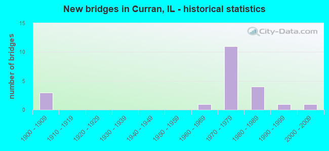
- New bridges - historical statistics
- 31900-1909
- 11960-1969
- 111970-1979
- 41980-1989
- 11990-1999
- 12000-2009


- Bridge Condition - Deck
- 8.3%Very good
- 75.0%Good
- 8.3%Fair
- 8.3%Poor

- Bridge Condition - Superstructure
- 8.3%Very good
- 75.0%Good
- 8.3%Fair
- 8.3%Poor

- Bridge Condition - Substructure
- 8.3%Very good
- 75.0%Good
- 8.3%Satisfactory
- 8.3%Fair

- Bridge Condition - Channel
- 8.3%Very good
- 41.7%Good
- 33.3%Satisfactory
- 16.7%Fair
Find on map >> Show street view
Structure Number: 840144, Location: 5.5M W WABASH INTCHG (Lat: 39.741239, Lng: -89.844231), Route carried "on" structure: County highway , Year Built: 1974, Status: Open, Structure Length: 7.50m (24.61ft), Average Daily Traffic: 100 (year 2017), Truck Traffic: 16%, Average Future Daily Traffic: 188 (year 2032), Design Load: HS 15, Features Intersected: I-72 / US 36, Facility Carried by Structure: TOLLIVER/BATES RD
Minimum Vertical Clearance: 30+ m (98+ ft), Kilometerpoint: 0.772, Lanes on structure: 2, Lanes under structure: 4, Owner: State Highway Agency, Approaching Roadway Width: 8.5m (27.9ft), Material/Design: Steel continuous, Design/Construction: Box Beam or Girders - Single/Spread, Number Of Spans In Main Unit: 2, Number Of Approach Spans: 2, Length of Maximum Span: 32.3m (106.0ft), Curb-To-Curb Width: 8.1m (26.6ft), Out-to-Out Width: 9.1m (29.9ft)
Condition: Deck: Good, Superstructure: Good, Substructure: Good, Operating Rating: 37.6 metric tons, Method Used To Determine Operating Rating: Allowable Stress (AS) rating reported by rating factor (RF) method using MS18 loading, Inventory Rating: 24.3 metric tons, Method Used To Determine Inventory Rating: Allowable Stress (AS) rating reported by rating factor (RF) method using MS18 loading, Structural Evaluation: Equal to present minimum criteria, Deck Geometry: Equal to present minimum criteria, Underclear: Meets minimum limits, Approach Roadway Alignment: Equal to present desirable criteria, Designated Inspection Frequency: Every 24 months, Critical Feature Inspection Frequency: Every 24 months, Inspection Date: August 2021, Critical Feature Inspection Date: August 2021, Deck Structure Type: Concrete Cast-file-Place, Wearing Surface/Protective System: Wearing Surface: Bituminous, Membrane: Built-up
Find on map >> Show street view
Structure Number: 840145, Location: 2.6M W WABASH INTCHG (Lat: 39.751475, Lng: -89.799906), Route carried "on" structure: County highway , Year Built: 1974, Status: Open, Structure Length: 7.52m (24.67ft), Average Daily Traffic: 850 (year 2017), Truck Traffic: 9%, Average Future Daily Traffic: 750 (year 2032), Design Load: HS 15, Features Intersected: I-72 / US 36, Facility Carried by Structure: FARMINGDALE RD/CH
Minimum Vertical Clearance: 30+ m (98+ ft), Kilometerpoint: 10.332, Lanes on structure: 2, Lanes under structure: 4, Owner: State Highway Agency, Approaching Roadway Width: 9.1m (29.9ft), Skew: 1 degrees, Material/Design: Steel continuous, Design/Construction: Stringer/Multi-beam, Number Of Spans In Main Unit: 2, Number Of Approach Spans: 2, Length of Maximum Span: 32.9m (107.9ft), Curb-To-Curb Width: 8.7m (28.5ft), Out-to-Out Width: 9.8m (32.2ft)
Condition: Deck: Good, Superstructure: Good, Substructure: Good, Operating Rating: 51.5 metric tons, Method Used To Determine Operating Rating: Allowable Stress (AS) rating reported by rating factor (RF) method using MS18 loading, Inventory Rating: 28.8 metric tons, Method Used To Determine Inventory Rating: Allowable Stress (AS) rating reported by rating factor (RF) method using MS18 loading, Structural Evaluation: Better than present minimum criteria, Deck Geometry: Somewhat better than minimum adequacy, Underclear: Meets minimum limits, Approach Roadway Alignment: Equal to present desirable criteria, Designated Inspection Frequency: Every 24 months, Inspection Date: September 2021, Deck Structure Type: Concrete Cast-file-Place, Wearing Surface/Protective System: Wearing Surface: Bituminous, Membrane: Built-up
Find on map >> Show street view
Structure Number: 840146, Location: 1.1M W WABASH INTCHG (Lat: 39.751981, Lng: -89.771847), Route carried "on" structure: Other road , Year Built: 1974, Status: Open, Structure Length: 7.02m (23.03ft), Average Daily Traffic: 450 (year 2017), Truck Traffic: 22%, Average Future Daily Traffic: 482 (year 2032), Design Load: HS 15, Features Intersected: I- 72 / US 36, Facility Carried by Structure: CURRAN RD (TR 156)
Minimum Vertical Clearance: 30+ m (98+ ft), Kilometerpoint: 0.451, Lanes on structure: 2, Lanes under structure: 4, Owner: State Highway Agency, Approaching Roadway Width: 8.5m (27.9ft), Material/Design: Steel continuous, Design/Construction: Stringer/Multi-beam, Number Of Spans In Main Unit: 2, Number Of Approach Spans: 2, Length of Maximum Span: 30.2m (99.1ft), Curb-To-Curb Width: 8.1m (26.6ft), Out-to-Out Width: 9.1m (29.9ft)
Condition: Deck: Good, Superstructure: Good, Substructure: Good, Operating Rating: 43.4 metric tons, Method Used To Determine Operating Rating: Allowable Stress (AS) rating reported by rating factor (RF) method using MS18 loading, Inventory Rating: 25.9 metric tons, Method Used To Determine Inventory Rating: Allowable Stress (AS) rating reported by rating factor (RF) method using MS18 loading, Structural Evaluation: Equal to present minimum criteria, Deck Geometry: Somewhat better than minimum adequacy, Underclear: Meets minimum limits, Approach Roadway Alignment: Equal to present desirable criteria, Designated Inspection Frequency: Every 24 months, Inspection Date: September 2021, Deck Structure Type: Concrete Cast-file-Place, Wearing Surface/Protective System: Wearing Surface: Bituminous, Membrane: Built-up
Find on map >> Show street view
Structure Number: 842012, Location: .8M W WABASH INTCHG (Lat: 39.751756, Lng: -89.765750), Route carried "on" structure: Interstate 72, Year Built: 1975, Status: Open, Structure Length: 0.79m (2.59ft), Average Daily Traffic: 17,000 (year 2021), Truck Traffic: 20%, Average Future Daily Traffic: 15,008 (year 2032), Design Load: HS 20, Features Intersected: LITTLE SPRING CR BR
Minimum Vertical Clearance: 30+ m (98+ ft), Kilometerpoint: 147.122, Lanes on structure: 4, Base Highway Network: Yes, Owner: State Highway Agency, Approaching Roadway Width: 12.2m (40.0ft), Material/Design: Concrete, Design/Construction: Culvert, Number Of Spans In Main Unit: 2, Length of Maximum Span: 3.7m (12.1ft)
Condition: Channel: Satisfactory, Culverts: Good, Operating Rating: 97.2 metric tons, Method Used To Determine Operating Rating: Load Factor (LF) rating reported by rating factor (RF) method using MS18 loading, Inventory Rating: 64.2 metric tons, Method Used To Determine Inventory Rating: Load Factor (LF) rating reported by rating factor (RF) method using MS18 loading, Structural Evaluation: Better than present minimum criteria, Waterway Adequacy: Superior to present desirable criteria, Approach Roadway Alignment: Equal to present desirable criteria, Designated Inspection Frequency: Every 24 months, Inspection Date: January 2022
Find on map >> Show street view
Structure Number: 842013, Location: .25M W FARMINGDAL RD (Lat: 39.749972, Lng: -89.804319), Route carried "on" structure: Interstate 72, Year Built: 1975, Status: Open, Structure Length: 0.68m (2.23ft), Average Daily Traffic: 17,000 (year 2021), Truck Traffic: 20%, Average Future Daily Traffic: 15,008 (year 2032), Design Load: HS 20, Features Intersected: LITTLE SPRING CREEK
Minimum Vertical Clearance: 30+ m (98+ ft), Kilometerpoint: 143.759, Lanes on structure: 4, Base Highway Network: Yes, Owner: State Highway Agency, Approaching Roadway Width: 12.2m (40.0ft), Material/Design: Concrete, Design/Construction: Culvert, Number Of Spans In Main Unit: 2, Length of Maximum Span: 3.0m (9.8ft)
Condition: Channel: Good, Culverts: Good, Operating Rating: 54.1 metric tons, Method Used To Determine Operating Rating: Field evaluation and documented engineering judgment, Inventory Rating: 32.4 metric tons, Method Used To Determine Inventory Rating: Field evaluation and documented engineering judgment, Structural Evaluation: Better than present minimum criteria, Waterway Adequacy: Superior to present desirable criteria, Approach Roadway Alignment: Better than present minimum criteria, Designated Inspection Frequency: Every 24 months, Inspection Date: October 2020
Find on map >> Show street view
Structure Number: 843086, Location: 4.0 E BERLIN (Lat: 39.772217, Lng: -89.828664), Route carried "on" structure: County highway , Year Built: 1970, Status: Open, Structure Length: 2.68m (8.79ft), Average Daily Traffic: 175 (year 2017), Truck Traffic: 6%, Average Future Daily Traffic: 188 (year 2032), Design Load: HS 15, Features Intersected: SPRING CREEK, Facility Carried by Structure: TR 100 (9.5W)
Minimum Vertical Clearance: 30+ m (98+ ft), Kilometerpoint: 0.612, Lanes on structure: 2, Owner: Town or Township Highway Agency, Approaching Roadway Width: 5.5m (18.0ft), Material/Design: Prestressed concrete, Design/Construction: Box Beam or Girders - Multiple, Number Of Spans In Main Unit: 3, Length of Maximum Span: 9.0m (29.5ft), Curb-To-Curb Width: 7.6m (24.9ft), Out-to-Out Width: 7.9m (25.9ft)
Condition: Deck: Poor, Superstructure: Poor, Substructure: Fair, Channel: Fair, Operating Rating: 27.9 metric tons, Method Used To Determine Operating Rating: Load Factor (LF) rating reported by rating factor (RF) method using MS18 loading, Inventory Rating: 16.8 metric tons, Method Used To Determine Inventory Rating: Load Factor (LF) rating reported by rating factor (RF) method using MS18 loading, Structural Evaluation: Meets minimum limits, Deck Geometry: Somewhat better than minimum adequacy, Waterway Adequacy: Better than present minimum criteria, Approach Roadway Alignment: Equal to present minimum criteria, Length Of Structure Improvement: 2.68m (8.79ft), Designated Inspection Frequency: Every 24 months, Other Special Inspection Frequency: Every 12 months, Inspection Date: March 2021, Other Special Inspection Date: March 2021, Bridge Improvement Cost: $109,000, Roadway Improvement Cost: $11,000, Total Project Cost: $164,000, Deck Structure Type: Concrete Precast Panels, Wearing Surface/Protective System: Wearing Surface: Bituminous
Find on map >> Show street view
Structure Number: 843089, Location: 1.5 S FARMINGDALE (Lat: 39.795061, Lng: -89.824261), Route carried "on" structure: County highway , Year Built: 1970, Status: Open, Structure Length: 4.15m (13.62ft), Average Daily Traffic: 50 (year 2017), Truck Traffic: 12%, Average Future Daily Traffic: 214 (year 2032), Design Load: HS 15, Features Intersected: SPRING CREEK, Facility Carried by Structure: TR 104 (9W)
Minimum Vertical Clearance: 30+ m (98+ ft), Kilometerpoint: 10.702, Lanes on structure: 2, Owner: Town or Township Highway Agency, Approaching Roadway Width: 4.3m (14.1ft), Material/Design: Prestressed concrete, Design/Construction: Box Beam or Girders - Multiple, Number Of Spans In Main Unit: 3, Length of Maximum Span: 14.0m (45.9ft), Curb-To-Curb Width: 7.5m (24.6ft), Out-to-Out Width: 8.1m (26.6ft)
Condition: Deck: Fair, Superstructure: Fair, Substructure: Satisfactory, Channel: Satisfactory, Operating Rating: 43.7 metric tons, Method Used To Determine Operating Rating: Load Factor (LF) rating reported by rating factor (RF) method using MS18 loading, Inventory Rating: 26.2 metric tons, Method Used To Determine Inventory Rating: Load Factor (LF) rating reported by rating factor (RF) method using MS18 loading, Structural Evaluation: Somewhat better than minimum adequacy, Deck Geometry: Equal to present minimum criteria, Waterway Adequacy: Better than present minimum criteria, Approach Roadway Alignment: Better than present minimum criteria, Designated Inspection Frequency: Every 24 months, Inspection Date: March 2021, Deck Structure Type: Concrete Precast Panels, Wearing Surface/Protective System: Wearing Surface: Bituminous
Find on map >> Show street view
Structure Number: 843131, Location: 1.0 MI N CURRAN (Lat: 39.756331, Lng: -89.766158), Route carried "on" structure: Other road , Year Built: 1900, Status: Open, Structure Length: 0.70m (2.30ft), Average Daily Traffic: 900 (year 2012), Truck Traffic: 4%, Average Future Daily Traffic: 1,018 (year 2032), Features Intersected: LITTLE SPRING CREEK, Facility Carried by Structure: TR 249
Minimum Vertical Clearance: 30+ m (98+ ft), Kilometerpoint: 0.515, Lanes on structure: 1, Owner: Town or Township Highway Agency, Approaching Roadway Width: 5.5m (18.0ft), Material/Design: Steel, Design/Construction: Stringer/Multi-beam, Number Of Spans In Main Unit: 2, Length of Maximum Span: 3.5m (11.5ft), Curb-To-Curb Width: 4.0m (13.1ft), Out-to-Out Width: 4.4m (14.4ft)
Condition: Deck: Good, Superstructure: Good, Substructure: Good, Channel: Satisfactory, Operating Rating: 33.4 metric tons, Method Used To Determine Operating Rating: Load Factor (LF) rating reported by rating factor (RF) method using MS18 loading, Inventory Rating: 20.1 metric tons, Method Used To Determine Inventory Rating: Load Factor (LF) rating reported by rating factor (RF) method using MS18 loading, Structural Evaluation: Somewhat better than minimum adequacy, Deck Geometry: High priority of replacement, Waterway Adequacy: Meets minimum limits, Approach Roadway Alignment: Better than present minimum criteria, Length Of Structure Improvement: 1.34m (4.40ft), Designated Inspection Frequency: Every 24 months, Inspection Date: March 2021, Bridge Improvement Cost: $29,000, Roadway Improvement Cost: $3,000, Total Project Cost: $44,000, Deck Structure Type: Concrete Precast Panels, Wearing Surface/Protective System: Wearing Surface: Bituminous
Find on map >> Show street view
Structure Number: 843401, Location: 2.0 W RIDDLE HILL (Lat: 39.781569, Lng: -89.811508), Route carried "on" structure: County highway , Year Built: 1985, Status: Open, Structure Length: 3.08m (10.10ft), Average Daily Traffic: 2,500 (year 2017), Truck Traffic: 11%, Average Future Daily Traffic: 2,680 (year 2032), Design Load: HS 20, Features Intersected: BRANCH SPRING CREEK, Facility Carried by Structure: FAS613-CH 8
Minimum Vertical Clearance: 30+ m (98+ ft), Kilometerpoint: 15.481, Lanes on structure: 2, Owner: County Highway Agency, Approaching Roadway Width: 7.3m (24.0ft), Skew: 2 degrees, Material/Design: Prestressed concrete, Design/Construction: Box Beam or Girders - Multiple, Number Of Spans In Main Unit: 3, Length of Maximum Span: 12.2m (40.0ft), Curb-To-Curb Width: 12.2m (40.0ft), Out-to-Out Width: 12.2m (40.0ft)
Condition: Deck: Good, Superstructure: Good, Substructure: Good, Channel: Good, Operating Rating: 52.8 metric tons, Method Used To Determine Operating Rating: Load Factor (LF) rating reported by rating factor (RF) method using MS18 loading, Inventory Rating: 31.8 metric tons, Method Used To Determine Inventory Rating: Load Factor (LF) rating reported by rating factor (RF) method using MS18 loading, Structural Evaluation: Better than present minimum criteria, Deck Geometry: Equal to present minimum criteria, Waterway Adequacy: Better than present minimum criteria, Approach Roadway Alignment: Equal to present desirable criteria, Designated Inspection Frequency: Every 48 months, Inspection Date: March 2018, Deck Structure Type: Concrete Precast Panels, Wearing Surface/Protective System: Wearing Surface: Bituminous, Membrane: Built-up, Deck Protection: Internally Sealed
Find on map >> Show street view
Structure Number: 843407, Location: 2 M NW CURRAN (Lat: 39.769053, Lng: -89.800300), Route carried "on" structure: County highway , Year Built: 2008, Status: Open, Structure Length: 2.22m (7.28ft), Average Daily Traffic: 1,150 (year 2017), Truck Traffic: 5%, Average Future Daily Traffic: 643 (year 2032), Design Load: HS 20, Features Intersected: LITTLE SPRING CR, Facility Carried by Structure: CH-15
Minimum Vertical Clearance: 30+ m (98+ ft), Kilometerpoint: 8.401, Lanes on structure: 2, Owner: County Highway Agency, Approaching Roadway Width: 12.2m (40.0ft), Material/Design: Steel, Design/Construction: Stringer/Multi-beam, Number Of Spans In Main Unit: 1, Length of Maximum Span: 21.3m (69.9ft), Curb-To-Curb Width: 12.2m (40.0ft), Out-to-Out Width: 12.2m (40.0ft)
Condition: Deck: Very good, Superstructure: Very good, Substructure: Very good, Channel: Very good, Operating Rating: 44.1 metric tons, Method Used To Determine Operating Rating: Assigned rating based on Load Factor Design (LFD) reported by rating factor (RF) using MS18 loading, Inventory Rating: 32.4 metric tons, Method Used To Determine Inventory Rating: Assigned rating based on Load Factor Design (LFD) reported by rating factor (RF) using MS18 loading, Structural Evaluation: Equal to present desirable criteria, Deck Geometry: Better than present minimum criteria, Waterway Adequacy: Equal to present desirable criteria, Approach Roadway Alignment: Equal to present desirable criteria, Designated Inspection Frequency: Every 48 months, Inspection Date: March 2018, Deck Structure Type: Concrete Cast-file-Place
Find on map >> Show street view
Structure Number: 843429, Location: 2.5 MI S CURRAN (Lat: 39.703425, Lng: -89.771069), Route carried "on" structure: County highway , Year Built: 1988, Status: Open, Structure Length: 2.47m (8.10ft), Average Daily Traffic: 2,050 (year 2017), Truck Traffic: 9%, Average Future Daily Traffic: 1,662 (year 2032), Design Load: HS 20, Features Intersected: LICK CREEK, Facility Carried by Structure: FAS1619/CH18
Minimum Vertical Clearance: 30+ m (98+ ft), Kilometerpoint: 1.819, Lanes on structure: 2, Owner: County Highway Agency, Approaching Roadway Width: 7.3m (24.0ft), Material/Design: Prestressed concrete, Design/Construction: Box Beam or Girders - Multiple, Number Of Spans In Main Unit: 1, Length of Maximum Span: 24.1m (79.1ft), Curb-To-Curb Width: 11.1m (36.4ft), Out-to-Out Width: 11.1m (36.4ft)
Condition: Deck: Good, Superstructure: Good, Substructure: Good, Channel: Good, Operating Rating: 61.6 metric tons, Method Used To Determine Operating Rating: Load Factor (LF) rating reported by rating factor (RF) method using MS18 loading, Inventory Rating: 35.3 metric tons, Method Used To Determine Inventory Rating: Load Factor (LF) rating reported by rating factor (RF) method using MS18 loading, Structural Evaluation: Better than present minimum criteria, Deck Geometry: Somewhat better than minimum adequacy, Waterway Adequacy: Better than present minimum criteria, Approach Roadway Alignment: Equal to present desirable criteria, Designated Inspection Frequency: Every 48 months, Inspection Date: March 2018, Deck Structure Type: Concrete Precast Panels, Wearing Surface/Protective System: Wearing Surface: Bituminous, Membrane: Built-up, Deck Protection: Internally Sealed
Find on map >> Show street view
Structure Number: 84343, Location: 3.5 MI S CURRAN (Lat: 39.694686, Lng: -89.770756), Route carried "on" structure: County highway , Year Built: 1988, Status: Open, Structure Length: 7.19m (23.59ft), Average Daily Traffic: 1,750 (year 2017), Truck Traffic: 6%, Average Future Daily Traffic: 1,233 (year 2032), Design Load: HS 20, Features Intersected: LICK CREEK, Facility Carried by Structure: FAS1619/CH18
Minimum Vertical Clearance: 30+ m (98+ ft), Kilometerpoint: 2.784, Lanes on structure: 2, Owner: County Highway Agency, Approaching Roadway Width: 7.3m (24.0ft), Material/Design: Prestressed concrete, Design/Construction: Box Beam or Girders - Multiple, Number Of Spans In Main Unit: 3, Length of Maximum Span: 23.8m (78.1ft), Curb-To-Curb Width: 11.1m (36.4ft), Out-to-Out Width: 11.1m (36.4ft)
Condition: Deck: Good, Superstructure: Good, Substructure: Good, Channel: Satisfactory, Operating Rating: 62.9 metric tons, Method Used To Determine Operating Rating: Load Factor (LF) rating reported by rating factor (RF) method using MS18 loading, Inventory Rating: 36.9 metric tons, Method Used To Determine Inventory Rating: Load Factor (LF) rating reported by rating factor (RF) method using MS18 loading, Structural Evaluation: Better than present minimum criteria, Deck Geometry: Equal to present minimum criteria, Waterway Adequacy: Equal to present minimum criteria, Approach Roadway Alignment: Equal to present desirable criteria, Designated Inspection Frequency: Every 48 months, Inspection Date: March 2018, Deck Structure Type: Concrete Precast Panels, Wearing Surface/Protective System: Wearing Surface: Bituminous, Membrane: Built-up, Deck Protection: Internally Sealed
Find on map >> Show street view
Structure Number: 84349, Location: 3.5 MI NW CURRAN (Lat: 39.780014, Lng: -89.816350), Route carried "on" structure: County highway , Year Built: 1993, Status: Open, Structure Length: 2.23m (7.32ft), Average Daily Traffic: 150 (year 2007), Average Future Daily Traffic: 161 (year 2032), Design Load: HS 20, Features Intersected: SPRING CREEK, Facility Carried by Structure: TR 104
Minimum Vertical Clearance: 30+ m (98+ ft), Kilometerpoint: 12.939, Lanes on structure: 2, Owner: Town or Township Highway Agency, Approaching Roadway Width: 5.5m (18.0ft), Material/Design: Prestressed concrete, Design/Construction: Box Beam or Girders - Multiple, Number Of Spans In Main Unit: 1, Length of Maximum Span: 21.5m (70.5ft), Curb-To-Curb Width: 8.2m (26.9ft), Out-to-Out Width: 8.2m (26.9ft)
Condition: Deck: Good, Superstructure: Good, Substructure: Good, Channel: Good, Operating Rating: 44.1 metric tons, Method Used To Determine Operating Rating: Assigned rating based on Load Factor Design (LFD) reported by rating factor (RF) using MS18 loading, Inventory Rating: 32.4 metric tons, Method Used To Determine Inventory Rating: Assigned rating based on Load Factor Design (LFD) reported by rating factor (RF) using MS18 loading, Structural Evaluation: Better than present minimum criteria, Deck Geometry: Somewhat better than minimum adequacy, Waterway Adequacy: Better than present minimum criteria, Approach Roadway Alignment: Equal to present desirable criteria, Designated Inspection Frequency: Every 48 months, Inspection Date: March 2018, Deck Structure Type: Concrete Precast Panels, Wearing Surface/Protective System: Wearing Surface: Bituminous
Find on map >> Show street view
Structure Number: 843494, Location: 2.0 NE OF LOAMI (Lat: 39.711844, Lng: -89.794619), Route carried "on" structure: County highway , Year Built: 1987, Status: Open, Structure Length: 2.50m (8.20ft), Average Daily Traffic: 75 (year 2017), Truck Traffic: 27%, Average Future Daily Traffic: 161 (year 2032), Design Load: HS 20, Features Intersected: SAMPSON CREEK, Facility Carried by Structure: TR 122
Minimum Vertical Clearance: 30+ m (98+ ft), Kilometerpoint: 0.080, Lanes on structure: 2, Owner: Town or Township Highway Agency, Approaching Roadway Width: 6.1m (20.0ft), Skew: 3 degrees, Material/Design: Prestressed concrete, Design/Construction: Box Beam or Girders - Multiple, Number Of Spans In Main Unit: 1, Length of Maximum Span: 24.5m (80.4ft), Curb-To-Curb Width: 8.2m (26.9ft), Out-to-Out Width: 8.2m (26.9ft)
Condition: Deck: Good, Superstructure: Good, Substructure: Good, Channel: Good, Operating Rating: 44.1 metric tons, Method Used To Determine Operating Rating: Assigned rating based on Load Factor Design (LFD) reported by rating factor (RF) using MS18 loading, Inventory Rating: 32.4 metric tons, Method Used To Determine Inventory Rating: Assigned rating based on Load Factor Design (LFD) reported by rating factor (RF) using MS18 loading, Structural Evaluation: Better than present minimum criteria, Deck Geometry: Equal to present minimum criteria, Waterway Adequacy: Better than present minimum criteria, Approach Roadway Alignment: Equal to present desirable criteria, Designated Inspection Frequency: Every 48 months, Inspection Date: March 2018, Deck Structure Type: Concrete Precast Panels, Wearing Surface/Protective System: Wearing Surface: Bituminous
Find on map >> Show street view
Structure Number: 845011, Location: 2.5 NE OF LOAMI (Lat: 39.715822, Lng: -89.815564), Route carried "on" structure: County highway , Year Built: 1967, Status: Open, Structure Length: 0.93m (3.05ft), Average Daily Traffic: 225 (year 2007), Truck Traffic: 9%, Average Future Daily Traffic: 241 (year 2032), Design Load: HS 15, Features Intersected: SAMPSON CREEK, Facility Carried by Structure: TR 110 9 W
Minimum Vertical Clearance: 30+ m (98+ ft), Kilometerpoint: 0.435, Lanes on structure: 2, Owner: Town or Township Highway Agency, Approaching Roadway Width: 6.1m (20.0ft), Skew: 4 degrees, Material/Design: Concrete continuous, Design/Construction: Culvert, Number Of Spans In Main Unit: 2, Length of Maximum Span: 4.5m (14.8ft), Curb-To-Curb Width: 7.3m (24.0ft), Out-to-Out Width: 8.0m (26.2ft)
Condition: Channel: Fair, Culverts: Good, Operating Rating: 36.9 metric tons, Method Used To Determine Operating Rating: Load Factor (LF) rating reported by rating factor (RF) method using MS18 loading, Inventory Rating: 22.0 metric tons, Method Used To Determine Inventory Rating: Load Factor (LF) rating reported by rating factor (RF) method using MS18 loading, Structural Evaluation: Equal to present minimum criteria, Deck Geometry: Somewhat better than minimum adequacy, Waterway Adequacy: Better than present minimum criteria, Approach Roadway Alignment: Better than present minimum criteria, Designated Inspection Frequency: Every 24 months, Inspection Date: March 2020, Wearing Surface/Protective System: Wearing Surface: Gravel
Find on map >> Show street view
Structure Number: 840144, Location: 5.5M W WABASH INTCHG (Lat: 39.740919, Lng: -89.844219), Route carried "under" structure: Interstate 72, Year Built: 1974, Structure Length: 0. m, Average Daily Traffic: 17,000 (year 2021), Truck Traffic: 20%, Features Intersected: I-72 / US 36, Facility Carried by Structure: TOLLIVER/BATES RD
Minimum Vertical Clearance: 5.00m (16.40ft), Kilometerpoint: 140.122, Lanes on structure: 2, Lanes under structure: 4, Material/Design: Steel continuous, Design/Construction: Box Beam or Girders - Single/Spread, Length of Maximum Span: 32.3m (106.0ft)
Find on map >> Show street view
Structure Number: 840145, Location: 2.6M W WABASH INTCHG (Lat: 39.751194, Lng: -89.799903), Route carried "under" structure: Interstate 72, Year Built: 1974, Structure Length: 0. m, Average Daily Traffic: 17,000 (year 2021), Truck Traffic: 20%, Features Intersected: I-72 / US 36, Facility Carried by Structure: FARMINGDALE RD/CH
Minimum Vertical Clearance: 5.31m (17.42ft), Kilometerpoint: 144.193, Lanes on structure: 2, Lanes under structure: 4, Material/Design: Steel continuous, Design/Construction: Stringer/Multi-beam, Length of Maximum Span: 32.9m (107.9ft)
Find on map >> Show street view
Structure Number: 840146, Location: 1.1M W WABASH INTCHG (Lat: 39.751722, Lng: -89.771844), Route carried "under" structure: Interstate 72, Year Built: 1974, Structure Length: 0. m, Average Daily Traffic: 17,000 (year 2021), Truck Traffic: 20%, Features Intersected: I- 72 / US 36, Facility Carried by Structure: CURRAN RD (TR 156)
Minimum Vertical Clearance: 5.16m (16.93ft), Kilometerpoint: 146.575, Lanes on structure: 2, Lanes under structure: 4, Material/Design: Steel continuous, Design/Construction: Stringer/Multi-beam, Length of Maximum Span: 30.2m (99.1ft)
Find on map >> Show street view
Structure Number: 840147, Location: .56M W WABASH INTCHG (Lat: 39.751789, Lng: -89.761292), Route carried "under" structure: Interstate 72, Year Built: 1975, Structure Length: 0. m, Average Daily Traffic: 17,000 (year 2021), Truck Traffic: 20%, Features Intersected: I-72 / US 36, Facility Carried by Structure: UNION PACIFIC RR
Minimum Vertical Clearance: 5.18m (16.99ft), Kilometerpoint: 147.508, Lanes under structure: 4, Material/Design: Steel, Design/Construction: Stringer/Multi-beam, Length of Maximum Span: 25.3m (83.0ft)
Find on map >> Show street view
Structure Number: 849905, Location: .5M W CH 18 - CURRAN (Lat: 39.744425, Lng: -89.761144), Route carried "under" structure: Other road , Year Built: 1900, Structure Length: 0. m, Average Daily Traffic: 4,150 (year 2017), Truck Traffic: 7%, Features Intersected: OLD US 36, Facility Carried by Structure: UNION PACIFIC RR
Minimum Vertical Clearance: 5.97m (19.59ft), Kilometerpoint: 3.460, Lanes under structure: 2, Material/Design: Steel continuous, Design/Construction: Stringer/Multi-beam, Length of Maximum Span: 26.2m (86.0ft)
Find on map >> Show street view
Structure Number: 849922, Location: 3 M NE LOAMI (Lat: 39.715381, Lng: -89.815561), Route carried "under" structure: County highway , Year Built: 1906, Structure Length: 0. m, Average Daily Traffic: 225 (year 2007), Truck Traffic: 9%, Features Intersected: TR 110, Facility Carried by Structure: IC&G RR
Minimum Vertical Clearance: 4.57m (14.99ft), Kilometerpoint: 0.483, Lanes under structure: 2, Material/Design: Steel, Design/Construction: Girder and Floorbeam System, Length of Maximum Span: 10.1m (33.1ft)