Bridge Statistics for Dalton, Massachusetts (MA)
Condition, Traffic, Stress, Structural Evaluation, Project Costs
- National Bridge Inventory (NBI) Statistics
- 12Number of bridges
- 102ft / 31.3mTotal length
- $19,707,000Total costs
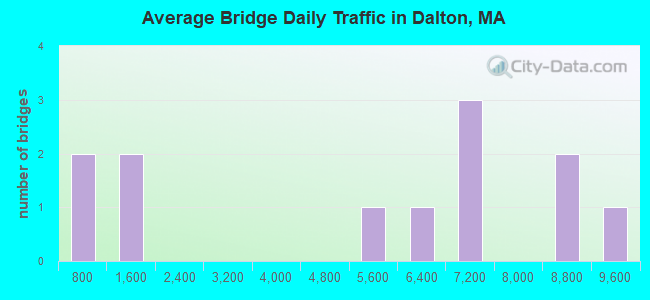
- 60,501Total average daily traffic
- 5,576Total average daily truck traffic
- 82,046Total future (year 2032) average daily traffic
- National Bridge Inventory (NBI) Registered Bridges for Dalton
- No street view available for this location
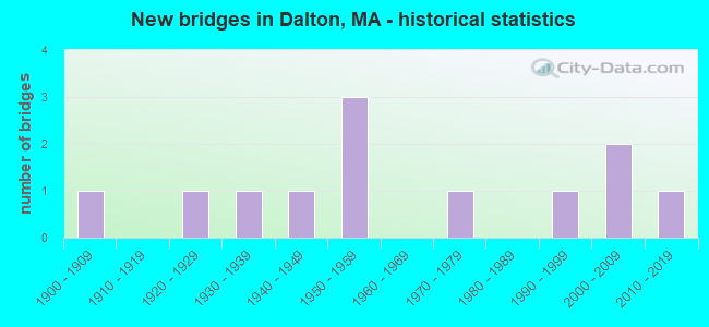
- New bridges - historical statistics
- 11900-1909
- 11920-1929
- 11930-1939
- 11940-1949
- 31950-1959
- 11970-1979
- 11990-1999
- 22000-2009
- 12010-2019
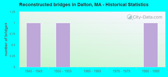
- Reconstructed bridges - Historical Statistics
- 11940-1949
- 11950-1959
- 01960-1969
- 01970-1979
- 11980-1989
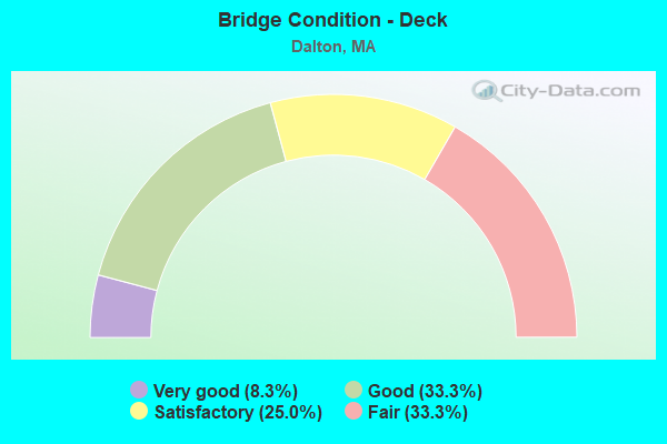
- Bridge Condition - Deck
- 8.3%Very good
- 33.3%Good
- 25.0%Satisfactory
- 33.3%Fair
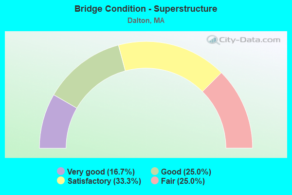
- Bridge Condition - Superstructure
- 16.7%Very good
- 25.0%Good
- 33.3%Satisfactory
- 25.0%Fair
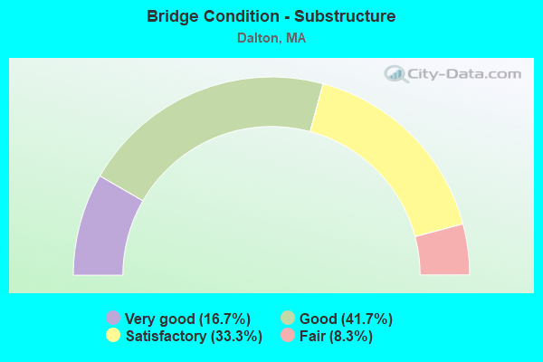
- Bridge Condition - Substructure
- 16.7%Very good
- 41.7%Good
- 33.3%Satisfactory
- 8.3%Fair
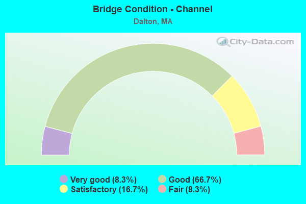
- Bridge Condition - Channel
- 8.3%Very good
- 66.7%Good
- 16.7%Satisfactory
- 8.3%Fair
Find on map >> Show street view
Structure Number: D0100100WMUNNBI, Location: .3MI S OF RT 9 @OLD S. ST (Lat: 42.468456, Lng: -73.181950), Route carried "on" structure: City street , Year Built: 1957, Status: Posted for load, Structure Length: 3.26m (10.70ft), Average Daily Traffic: 6,572 (year 2018), Truck Traffic: 1%, Average Future Daily Traffic: 9,002 (year 2032), Design Load: H 20, Features Intersected: WATER E BR HOUSATONIC R, Facility Carried by Structure: HWY SOUTH ST
Minimum Vertical Clearance: 30+ m (98+ ft), Kilometerpoint: 0.000, Lanes on structure: 2, Owner: Town or Township Highway Agency, Approaching Roadway Width: 7.9m (25.9ft), Skew: 2 degrees, Material/Design: Steel continuous, Design/Construction: Stringer/Multi-beam, Number Of Spans In Main Unit: 3, Length of Maximum Span: 18.0m (59.1ft), Curb or Sidewalk Widths: Left: 1.5m (4.9ft), Right: 0.3m (1.0ft), Curb-To-Curb Width: 9.1m (29.9ft), Out-to-Out Width: 11.9m (39.0ft)
Condition: Deck: Satisfactory, Superstructure: Fair, Substructure: Good, Channel: Good, Operating Rating: 38.8 metric tons, Method Used To Determine Operating Rating: Allowable Stress (AS), Inventory Rating: 19.7 metric tons, Method Used To Determine Inventory Rating: Allowable Stress (AS), Structural Evaluation: Meets minimum limits, Deck Geometry: High priority of corrective action, Waterway Adequacy: Equal to present desirable criteria, Approach Roadway Alignment: Equal to present desirable criteria, Length Of Structure Improvement: 3.30m (10.83ft), Designated Inspection Frequency: Every 24 months, Inspection Date: October 2021, Bridge Improvement Cost: $1,543,000, Roadway Improvement Cost: $155,000, Total Project Cost: $2,315,000 ( Estimate for 2022), Deck Structure Type: Concrete Cast-file-Place, Wearing Surface/Protective System: Wearing Surface: Bituminous
Find on map >> Show street view
Structure Number: D0100200UMUNNBI, Location: .5 M E OF RTE 9 (Lat: 42.470756, Lng: -73.168944), Route carried "on" structure: City street , Year Built: 1924, Year Reconstructed: 1989, Status: Posted for load, Structure Length: 4.66m (15.29ft), Average Daily Traffic: 7,198 (year 2018), Truck Traffic: 8%, Average Future Daily Traffic: 12,319 (year 2032), Design Load: H 15, Features Intersected: WATER E BR HOUSATONIC R, Facility Carried by Structure: HWY HOUSATONIC
Minimum Vertical Clearance: 30+ m (98+ ft), Kilometerpoint: 0.853, Lanes on structure: 2, Owner: Town or Township Highway Agency, Approaching Roadway Width: 7.3m (24.0ft), Material/Design: Steel, Design/Construction: Truss - Deck, Number Of Spans In Main Unit: 1, Number Of Approach Spans: 2, Length of Maximum Span: 32.0m (105.0ft), Curb-To-Curb Width: 7.0m (23.0ft), Out-to-Out Width: 7.6m (24.9ft)
Condition: Deck: Fair, Superstructure: Fair, Substructure: Satisfactory, Channel: Good, Operating Rating: 26.9 metric tons, Method Used To Determine Operating Rating: Load Factor (LF), Inventory Rating: 16.2 metric tons, Method Used To Determine Inventory Rating: Load Factor (LF), Structural Evaluation: Meets minimum limits, Deck Geometry: High priority of replacement, Waterway Adequacy: Equal to present desirable criteria, Approach Roadway Alignment: Somewhat better than minimum adequacy, Bridge Posting: Required (Relationship of Operating Rating to Maximum Legal Load: 10.0 - 19.9% below), Length Of Structure Improvement: 4.70m (15.42ft), Designated Inspection Frequency: Every 24 months, Critical Feature Inspection Frequency: Every 24 months, Inspection Date: June 2021, Critical Feature Inspection Date: June 2021, Bridge Improvement Cost: $1,404,000, Roadway Improvement Cost: $141,000, Total Project Cost: $2,107,000 ( Estimate for 2022), Deck Structure Type: Concrete Cast-file-Place, Wearing Surface/Protective System: Wearing Surface: Latex Concrete, Deck Protection: Epoxy Coated Reinforcing
Find on map >> Show street view
Structure Number: D0100400VMUNNBI, Location: .5 MILES SOUTH OF ROUTE 9 (Lat: 42.477222, Lng: -73.145000), Route carried "on" structure: City street , Year Built: 1952, Status: Posted for load, Structure Length: 2.60m (8.53ft), Average Daily Traffic: 1,300 (year 2011), Truck Traffic: 6%, Average Future Daily Traffic: 2,053 (year 2032), Design Load: H 15, Features Intersected: WATER E BR HOUSATONIC R, Facility Carried by Structure: HWY ORCHARD RD
Minimum Vertical Clearance: 30+ m (98+ ft), Kilometerpoint: 0.000, Lanes on structure: 2, Owner: Town or Township Highway Agency, Approaching Roadway Width: 7.9m (25.9ft), Skew: 1 degrees, Material/Design: Steel continuous, Design/Construction: Stringer/Multi-beam, Number Of Spans In Main Unit: 3, Length of Maximum Span: 16.2m (53.1ft), Curb or Sidewalk Widths: Left: 0.3m (1.0ft), Right: 0.3m (1.0ft), Curb-To-Curb Width: 7.9m (25.9ft), Out-to-Out Width: 9.3m (30.5ft)
Condition: Deck: Good, Superstructure: Good, Substructure: Good, Channel: Good, Operating Rating: 26.3 metric tons, Method Used To Determine Operating Rating: Load Factor (LF), Inventory Rating: 15.7 metric tons, Method Used To Determine Inventory Rating: Load Factor (LF), Structural Evaluation: Meets minimum limits, Deck Geometry: Meets minimum limits, Waterway Adequacy: Better than present minimum criteria, Approach Roadway Alignment: Equal to present desirable criteria, Bridge Posting: Required (Relationship of Operating Rating to Maximum Legal Load: 10.0 - 19.9% below), Length Of Structure Improvement: 2.70m (8.86ft), Designated Inspection Frequency: Every 24 months, Inspection Date: July 2021, Bridge Improvement Cost: $987,000, Roadway Improvement Cost: $99,000, Total Project Cost: $1,481,000 ( Estimate for 2022), Deck Structure Type: Concrete Cast-file-Place, Wearing Surface/Protective System: Wearing Surface: Bituminous
Find on map >> Show street view
Structure Number: D010050BGDOTNBI, Location: AT DEPOT ST INTERSECTION (Lat: 42.474119, Lng: -73.156797), Route carried "on" structure: State highway 8, Year Built: 1902, Year Reconstructed: 1954, Status: Open, Structure Length: 2.71m (8.89ft), Average Daily Traffic: 5,850 (year 2017), Truck Traffic: 10%, Average Future Daily Traffic: 6,001 (year 2032), Design Load: H 20, Features Intersected: WATER E BR HOUSATONIC R
Minimum Vertical Clearance: 30+ m (98+ ft), Kilometerpoint: 67.108, Lanes on structure: 2, Base Highway Network: Yes, Owner: State Highway Agency, Approaching Roadway Width: 12.2m (40.0ft), Material/Design: Steel, Design/Construction: Stringer/Multi-beam, Number Of Spans In Main Unit: 1, Length of Maximum Span: 25.9m (85.0ft), Curb or Sidewalk Widths: Left: 2.0m (6.6ft), Right: 2.0m (6.6ft), Curb-To-Curb Width: 12.2m (40.0ft), Out-to-Out Width: 16.6m (54.5ft)
Condition: Deck: Satisfactory, Superstructure: Satisfactory, Substructure: Satisfactory, Channel: Good, Operating Rating: 30.5 metric tons, Method Used To Determine Operating Rating: Allowable Stress (AS), Inventory Rating: 10.6 metric tons, Method Used To Determine Inventory Rating: Allowable Stress (AS), Structural Evaluation: High priority of corrective action, Deck Geometry: Somewhat better than minimum adequacy, Waterway Adequacy: Better than present minimum criteria, Approach Roadway Alignment: Equal to present desirable criteria, Bridge Posting: Required (Relationship of Operating Rating to Maximum Legal Load: 0.1 - 9.9% below), Length Of Structure Improvement: 2.80m (9.19ft), Designated Inspection Frequency: Every 24 months, Underwater Inspection Frequency: Every 36 months, Inspection Date: July 2021, Underwater Inspection Date: September 2020, Bridge Improvement Cost: $1,826,000, Roadway Improvement Cost: $183,000, Total Project Cost: $2,740,000 ( Estimate for 2022), Deck Structure Type: Concrete Cast-file-Place
Find on map >> Show street view
Structure Number: D01006045MUNNBI, Location: 1M E OF JCT RT8&9 (Lat: 42.473703, Lng: -73.141261), Route carried "on" structure: City street , Year Built: 1973, Status: Open, Structure Length: 1.40m (4.59ft), Average Daily Traffic: 1,069 (year 2019), Truck Traffic: 8%, Average Future Daily Traffic: 2,527 (year 2032), Design Load: H 20, Features Intersected: WATER E BR HOUSATONIC R, Facility Carried by Structure: HWY OLD WINDSOR
Minimum Vertical Clearance: 30+ m (98+ ft), Kilometerpoint: 0.000, Lanes on structure: 2, Owner: Town or Township Highway Agency, Approaching Roadway Width: 9.1m (29.9ft), Material/Design: Prestressed concrete, Design/Construction: Slab, Number Of Spans In Main Unit: 1, Length of Maximum Span: 13.6m (44.6ft), Curb or Sidewalk Widths: Left: 1.6m (5.2ft), Right: 1.6m (5.2ft), Curb-To-Curb Width: 9.1m (29.9ft), Out-to-Out Width: 13.4m (44.0ft)
Condition: Deck: Fair, Superstructure: Fair, Substructure: Satisfactory, Channel: Good, Operating Rating: 31.2 metric tons, Method Used To Determine Operating Rating: Load Factor (LF), Inventory Rating: 20.5 metric tons, Method Used To Determine Inventory Rating: Load Factor (LF), Structural Evaluation: Somewhat better than minimum adequacy, Deck Geometry: Somewhat better than minimum adequacy, Waterway Adequacy: Better than present minimum criteria, Approach Roadway Alignment: Equal to present desirable criteria, Bridge Posting: Required (Relationship of Operating Rating to Maximum Legal Load: 0.1 - 9.9% below), Length Of Structure Improvement: 1.50m (4.92ft), Designated Inspection Frequency: Every 24 months, Inspection Date: October 2021, Bridge Improvement Cost: $790,000, Roadway Improvement Cost: $80,000, Total Project Cost: $1,186,000 ( Estimate for 2022), Deck Structure Type: Concrete Precast Panels, Wearing Surface/Protective System: Wearing Surface: Bituminous, Membrane: Built-up
Find on map >> Show street view
Structure Number: D01007AR2DOTNBI, Location: 0.3 MI N OF HINSDALE TL (Lat: 42.457417, Lng: -73.130206), Route carried "on" structure: State highway 8, Year Built: 2009, Status: Open, Structure Length: 1.97m (6.46ft), Average Daily Traffic: 8,535 (year 2014), Truck Traffic: 10%, Average Future Daily Traffic: 12,003 (year 2031), Design Load: HS 25 or greater, Features Intersected: WATER E BR HOUSATONIC R
Minimum Vertical Clearance: 30+ m (98+ ft), Kilometerpoint: 63.632, Lanes on structure: 2, Owner: State Highway Agency, Approaching Roadway Width: 10.5m (34.4ft), Skew: 1 degrees, Material/Design: Prestressed concrete, Design/Construction: Box Beam or Girders - Single/Spread, Number Of Spans In Main Unit: 1, Length of Maximum Span: 18.0m (59.1ft), Curb-To-Curb Width: 10.5m (34.4ft), Out-to-Out Width: 11.5m (37.7ft)
Condition: Deck: Good, Superstructure: Good, Substructure: Good, Channel: Satisfactory, Inventory Rating: 64.4 metric tons, Method Used To Determine Inventory Rating: Load Factor (LF), Structural Evaluation: Better than present minimum criteria, Deck Geometry: Meets minimum limits, Waterway Adequacy: Equal to present desirable criteria, Approach Roadway Alignment: Equal to present desirable criteria, Length Of Structure Improvement: 2.00m (6.56ft), Designated Inspection Frequency: Every 24 months, Inspection Date: Febuary 2022, Bridge Improvement Cost: $547,000, Roadway Improvement Cost: $55,000, Total Project Cost: $821,000 ( Estimate for 2022), Deck Structure Type: Concrete Cast-file-Place, Wearing Surface/Protective System: Wearing Surface: Bituminous, Membrane: Preformed Fabric, Deck Protection: Epoxy Coated Reinforcing
Find on map >> Show street view
Structure Number: D0100800TMUNNBI, Location: BETWEEN EAST ST & ROUTE 8 (Lat: 42.466958, Lng: -73.142036), Route carried "on" structure: City street , Year Built: 1941, Status: Open, Structure Length: 2.56m (8.40ft), Average Daily Traffic: 7,198 (year 2018), Truck Traffic: 11%, Average Future Daily Traffic: 7,344 (year 2032), Design Load: H 20, Features Intersected: WATER E BR HOUSATONIC R, Facility Carried by Structure: HWY E HOUSATONIC
Minimum Vertical Clearance: 30+ m (98+ ft), Kilometerpoint: 0.000, Lanes on structure: 2, Owner: Town or Township Highway Agency, Approaching Roadway Width: 7.3m (24.0ft), Material/Design: Steel continuous, Design/Construction: Stringer/Multi-beam, Number Of Spans In Main Unit: 3, Length of Maximum Span: 16.5m (54.1ft), Curb or Sidewalk Widths: Left: 1.9m (6.2ft), Right: 0.2m (0.7ft), Curb-To-Curb Width: 9.1m (29.9ft), Out-to-Out Width: 12.3m (40.4ft)
Condition: Deck: Fair, Superstructure: Satisfactory, Substructure: Satisfactory, Channel: Good, Operating Rating: 47.4 metric tons, Method Used To Determine Operating Rating: Load Factor (LF), Inventory Rating: 28.4 metric tons, Method Used To Determine Inventory Rating: Load Factor (LF), Structural Evaluation: Equal to present minimum criteria, Deck Geometry: High priority of corrective action, Waterway Adequacy: Equal to present desirable criteria, Approach Roadway Alignment: Equal to present desirable criteria, Length Of Structure Improvement: 2.60m (8.53ft), Designated Inspection Frequency: Every 24 months, Inspection Date: October 2021, Bridge Improvement Cost: $1,257,000, Roadway Improvement Cost: $126,000, Total Project Cost: $1,886,000 ( Estimate for 2022), Deck Structure Type: Concrete Cast-file-Place, Wearing Surface/Protective System: Wearing Surface: Bituminous
Find on map >> Show street view
Structure Number: D01009AV9DOTNBI, Location: 500' N OF INT. W/ HOUSATO (Lat: 42.467919, Lng: -73.142458), Route carried "on" structure: State highway 8, Year Built: 2009, Status: Open, Structure Length: 3.60m (11.81ft), Average Daily Traffic: 8,535 (year 2014), Truck Traffic: 10%, Average Future Daily Traffic: 12,003 (year 2031), Design Load: HS 25 or greater, Features Intersected: WATER E BR HOUSATONIC R
Minimum Vertical Clearance: 30+ m (98+ ft), Kilometerpoint: 65.418, Lanes on structure: 2, Base Highway Network: Yes, Owner: State Highway Agency, Approaching Roadway Width: 10.5m (34.4ft), Skew: 5 degrees, Material/Design: Steel, Design/Construction: Stringer/Multi-beam, Number Of Spans In Main Unit: 1, Length of Maximum Span: 32.0m (105.0ft), Curb or Sidewalk Widths: Left: 1.7m (5.6ft), Right: 0.0m, Curb-To-Curb Width: 10.5m (34.4ft), Out-to-Out Width: 13.1m (43.0ft)
Condition: Deck: Good, Superstructure: Very good, Substructure: Very good, Channel: Very good, Inventory Rating: 71.1 metric tons, Method Used To Determine Inventory Rating: Load Factor (LF), Structural Evaluation: Equal to present desirable criteria, Deck Geometry: Meets minimum limits, Waterway Adequacy: Equal to present desirable criteria, Approach Roadway Alignment: Equal to present desirable criteria, Length Of Structure Improvement: 3.70m (12.14ft), Designated Inspection Frequency: Every 24 months, Inspection Date: Febuary 2022, Bridge Improvement Cost: $1,012,000, Roadway Improvement Cost: $102,000, Total Project Cost: $1,519,000 ( Estimate for 2022), Deck Structure Type: Concrete Cast-file-Place, Wearing Surface/Protective System: Wearing Surface: Monolithic Concrete, Deck Protection: Epoxy Coated Reinforcing
Find on map >> Show street view
Structure Number: D010100B7DOTNBI, Location: 1.8 MI W OF WINDSOR TL (Lat: 42.484272, Lng: -73.148494), Route carried "on" structure: State highway 9, Year Built: 1930, Year Reconstructed: 1955, Status: Open, Structure Length: 2.18m (7.15ft), Average Daily Traffic: 9,000 (year 2018), Truck Traffic: 12%, Average Future Daily Traffic: 11,845 (year 2032), Design Load: H 20, Features Intersected: WATER WAHCONAH FALLS BRK
Minimum Vertical Clearance: 30+ m (98+ ft), Kilometerpoint: 11.233, Lanes on structure: 2, Base Highway Network: Yes, Owner: State Highway Agency, Approaching Roadway Width: 13.1m (43.0ft), Skew: 3 degrees, Material/Design: Concrete continuous, Design/Construction: Tee Beam, Number Of Spans In Main Unit: 2, Length of Maximum Span: 9.4m (30.8ft), Curb or Sidewalk Widths: Left: 1.4m (4.6ft), Right: 0.2m (0.7ft), Curb-To-Curb Width: 13.3m (43.6ft), Out-to-Out Width: 16.0m (52.5ft)
Condition: Deck: Fair, Superstructure: Satisfactory, Substructure: Fair, Channel: Fair, Operating Rating: 46.5 metric tons, Method Used To Determine Operating Rating: Load Factor (LF), Inventory Rating: 37.6 metric tons, Method Used To Determine Inventory Rating: Load Factor (LF), Structural Evaluation: Somewhat better than minimum adequacy, Deck Geometry: Somewhat better than minimum adequacy, Waterway Adequacy: Equal to present minimum criteria, Approach Roadway Alignment: Equal to present desirable criteria, Length Of Structure Improvement: 2.20m (7.22ft), Designated Inspection Frequency: Every 24 months, Inspection Date: October 2021, Bridge Improvement Cost: $1,383,000, Roadway Improvement Cost: $139,000, Total Project Cost: $2,075,000 ( Estimate for 2022), Deck Structure Type: Concrete Cast-file-Place, Wearing Surface/Protective System: Wearing Surface: Bituminous
Find on map >> Show street view
Structure Number: D01011046MUNNBI, Location: 200 FT WEST OF RTE 9 (Lat: 42.485875, Lng: -73.137208), Route carried "on" structure: City street , Year Built: 1990, Status: Posted for load, Structure Length: 2.01m (6.59ft), Average Daily Traffic: 129 (year 2018), Truck Traffic: 10%, Average Future Daily Traffic: 158 (year 2033), Design Load: HS 20, Features Intersected: WATER WAHCONAH FALLS BRK, Facility Carried by Structure: HWY HOLIDY CTTG
Minimum Vertical Clearance: 30+ m (98+ ft), Kilometerpoint: 0.000, Lanes on structure: 1, Owner: Town or Township Highway Agency, Approaching Roadway Width: 4.6m (15.1ft), Material/Design: Steel, Design/Construction: Truss - Thru, Number Of Spans In Main Unit: 1, Length of Maximum Span: 17.7m (58.1ft), Curb-To-Curb Width: 3.4m (11.2ft), Out-to-Out Width: 3.7m (12.1ft)
Condition: Deck: Good, Superstructure: Good, Substructure: Good, Channel: Good, Operating Rating: 36.1 metric tons, Method Used To Determine Operating Rating: Load Factor (LF), Inventory Rating: 21.7 metric tons, Method Used To Determine Inventory Rating: Load Factor (LF), Structural Evaluation: Equal to present minimum criteria, Deck Geometry: High priority of replacement, Waterway Adequacy: Better than present minimum criteria, Approach Roadway Alignment: Equal to present desirable criteria, Length Of Structure Improvement: 2.80m (9.19ft), Designated Inspection Frequency: Every 24 months, Critical Feature Inspection Frequency: Every 24 months, Inspection Date: Febuary 2022, Critical Feature Inspection Date: Febuary 2022, Bridge Improvement Cost: $1,658,000, Roadway Improvement Cost: $166,000, Total Project Cost: $2,488,000 ( Estimate for 2022), Deck Structure Type: Steel plate, Wearing Surface/Protective System: Wearing Surface: Epoxy Overlay, Deck Protection: Other
Find on map >> Show street view
Structure Number: D01012B54MUNNBI, Location: .2 MI S OF RTE 9/8A (Lat: 42.486211, Lng: -73.128019), Route carried "on" structure: City street , Year Built: 2013, Status: Open, Structure Length: 1.80m (5.91ft), Average Daily Traffic: 240 (year 2013), Truck Traffic: 6%, Design Load: HL 93, Features Intersected: WATER WAHCONAH FALLS BRK, Facility Carried by Structure: HWY CLEVELAND RD
Minimum Vertical Clearance: 30+ m (98+ ft), Kilometerpoint: 0.000, Lanes on structure: 2, Owner: Town or Township Highway Agency, Approaching Roadway Width: 8.6m (28.2ft), Skew: 2 degrees, Material/Design: Prestressed concrete, Design/Construction: Box Beam or Girders - Single/Spread, Number Of Spans In Main Unit: 1, Length of Maximum Span: 16.7m (54.8ft), Curb-To-Curb Width: 8.6m (28.2ft), Out-to-Out Width: 9.6m (31.5ft)
Condition: Deck: Very good, Superstructure: Very good, Substructure: Very good, Channel: Good, Operating Rating: 77.8 metric tons, Method Used To Determine Operating Rating: Load and Resistance Factor Rating (LRFR) rating reported by rating factor(RF) method using HL-93 loadings, Inventory Rating: 38.9 metric tons, Method Used To Determine Inventory Rating: Load and Resistance Factor Rating (LRFR) rating reported by rating factor(RF) method using HL-93 loadings, Structural Evaluation: Equal to present desirable criteria, Deck Geometry: Equal to present minimum criteria, Waterway Adequacy: Better than present minimum criteria, Approach Roadway Alignment: Equal to present minimum criteria, Length Of Structure Improvement: 1.90m (6.23ft), Designated Inspection Frequency: Every 24 months, Inspection Date: Febuary 2021, Bridge Improvement Cost: $430,000, Roadway Improvement Cost: $44,000, Total Project Cost: $646,000 ( Estimate for 2022), Deck Structure Type: Concrete Cast-file-Place, Wearing Surface/Protective System: Wearing Surface: Bituminous, Membrane: Preformed Fabric, Deck Protection: Epoxy Coated Reinforcing
Find on map >> Show street view
Structure Number: D010190B6DOTNBI, Location: 0.5 MI E OF ORCHARD RD (Lat: 42.487222, Lng: -73.131667), Route carried "on" structure: State highway 9, Year Built: 1952, Status: Open, Structure Length: 2.56m (8.40ft), Average Daily Traffic: 4,875 (year 2021), Truck Traffic: 12%, Average Future Daily Traffic: 6,791 (year 2032), Design Load: H 20, Features Intersected: WATER WAHCONAH FALLS BRK
Minimum Vertical Clearance: 30+ m (98+ ft), Kilometerpoint: 12.697, Lanes on structure: 2, Base Highway Network: Yes, Owner: State Highway Agency, Approaching Roadway Width: 12.2m (40.0ft), Skew: 4 degrees, Material/Design: Steel, Design/Construction: Stringer/Multi-beam, Number Of Spans In Main Unit: 1, Length of Maximum Span: 21.3m (69.9ft), Curb or Sidewalk Widths: Left: 0.1m (0.3ft), Right: 0.1m (0.3ft), Curb-To-Curb Width: 12.2m (40.0ft), Out-to-Out Width: 13.7m (44.9ft)
Condition: Deck: Satisfactory, Superstructure: Satisfactory, Substructure: Good, Channel: Satisfactory, Operating Rating: 63.0 metric tons, Method Used To Determine Operating Rating: Load Factor (LF), Inventory Rating: 37.7 metric tons, Method Used To Determine Inventory Rating: Load Factor (LF), Structural Evaluation: Equal to present minimum criteria, Deck Geometry: Equal to present minimum criteria, Waterway Adequacy: Better than present minimum criteria, Approach Roadway Alignment: Equal to present desirable criteria, Length Of Structure Improvement: 2.60m (8.53ft), Designated Inspection Frequency: Every 24 months, Inspection Date: October 2021, Bridge Improvement Cost: $295,000, Roadway Improvement Cost: $30,000, Total Project Cost: $443,000 ( Estimate for 2022), Deck Structure Type: Concrete Cast-file-Place, Wearing Surface/Protective System: Wearing Surface: Bituminous