Bridge Statistics for Darlington, South Carolina (SC)
Condition, Traffic, Stress, Structural Evaluation, Project Costs
- National Bridge Inventory (NBI) Statistics
- 31Number of bridges
- 348ft / 106mTotal length
- $2,340,000Total costs
- 148,427Total average daily traffic
- 13,861Total average daily truck traffic
- National Bridge Inventory (NBI) Registered Bridges for Darlington
- No street view available for this location
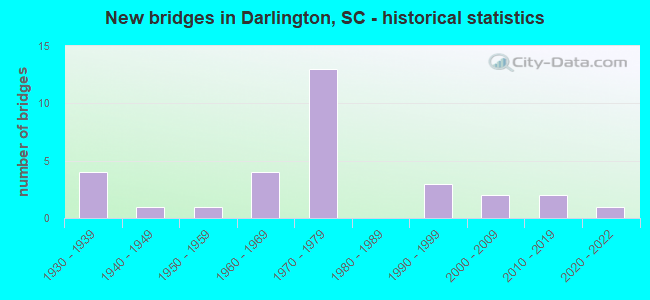
- New bridges - historical statistics
- 41930-1939
- 11940-1949
- 11950-1959
- 41960-1969
- 131970-1979
- 31990-1999
- 22000-2009
- 22010-2019
- 12020-2022

- Reconstructed bridges - Historical Statistics
- 11960-1969
- 11970-1979
- 21980-1989
- 21990-1999
- 22000-2009


- Bridge Condition - Deck
- 20.0%Very good
- 24.0%Good
- 32.0%Satisfactory
- 24.0%Fair

- Bridge Condition - Superstructure
- 24.0%Very good
- 24.0%Good
- 20.0%Satisfactory
- 28.0%Fair
- 4.0%Poor

- Bridge Condition - Substructure
- 24.0%Very good
- 44.0%Good
- 8.0%Satisfactory
- 24.0%Fair

- Bridge Condition - Channel
- 37.0%Very good
- 37.0%Good
- 25.9%Satisfactory
Find on map >> Show street view
Structure Number: 122, Location: IN DARLINGTON (Lat: 34.295175, Lng: -79.889933), Route carried "on" structure: State highway 34, Year Built: 1930, Year Reconstructed: 1972, Status: Open, Structure Length: 1.16m (3.81ft), Average Daily Traffic: 5,100 (year 2021), Truck Traffic: 3%, Average Future Daily Traffic: 3,417 (year 2041), Design Load: H 15, Features Intersected: INDIAN CREEK
Minimum Vertical Clearance: 30+ m (98+ ft), Kilometerpoint: 24.168, Lanes on structure: 2, Owner: State Highway Agency, Approaching Roadway Width: 19.5m (64.0ft), Material/Design: Concrete, Design/Construction: Culvert, Number Of Spans In Main Unit: 3, Length of Maximum Span: 3.7m (12.1ft), Curb-To-Curb Width: 18.3m (60.0ft), Out-to-Out Width: 28.2m (92.5ft)
Condition: Channel: Good, Culverts: Good, Operating Rating: 32.4 metric tons, Method Used To Determine Operating Rating: Load and Resistance Factor Rating (LRFR) rating reported by rating factor(RF) method using HL-93 loadings, Inventory Rating: 32.4 metric tons, Method Used To Determine Inventory Rating: Load and Resistance Factor Rating (LRFR) rating reported by rating factor(RF) method using HL-93 loadings, Structural Evaluation: Better than present minimum criteria, Deck Geometry: Superior to present desirable criteria, Waterway Adequacy: Equal to present minimum criteria, Approach Roadway Alignment: Equal to present minimum criteria, Length Of Structure Improvement: 1.16m (3.81ft), Designated Inspection Frequency: Every 24 months, Inspection Date: January 2022
Find on map >> Show street view
Structure Number: 602, Location: 3MI N OF DARLINGTON (Lat: 34.333744, Lng: -79.892642), Route carried "on" structure: Business US 52, Year Built: 1932, Status: Open, Structure Length: 1.30m (4.27ft), Average Daily Traffic: 1,750 (year 2020), Truck Traffic: 3%, Average Future Daily Traffic: 1,348 (year 2040), Design Load: H 15, Features Intersected: BELLYACHE CREEK
Minimum Vertical Clearance: 30+ m (98+ ft), Kilometerpoint: 6.700, Lanes on structure: 2, Base Highway Network: Yes, Owner: State Highway Agency, Approaching Roadway Width: 7.3m (24.0ft), Material/Design: Concrete, Design/Construction: Culvert, Number Of Spans In Main Unit: 4, Length of Maximum Span: 3.0m (9.8ft), Curb-To-Curb Width: 10.4m (34.1ft), Out-to-Out Width: 10.4m (34.1ft)
Condition: Channel: Good, Culverts: Good, Operating Rating: 22.0 metric tons, Method Used To Determine Operating Rating: Load and Resistance Factor Rating (LRFR) rating reported by rating factor(RF) method using HL-93 loadings, Inventory Rating: 16.8 metric tons, Method Used To Determine Inventory Rating: Load and Resistance Factor Rating (LRFR) rating reported by rating factor(RF) method using HL-93 loadings, Structural Evaluation: Meets minimum limits, Deck Geometry: Equal to present minimum criteria, Waterway Adequacy: Equal to present desirable criteria, Approach Roadway Alignment: Equal to present desirable criteria, Length Of Structure Improvement: 1.30m (4.27ft), Designated Inspection Frequency: Every 24 months, Inspection Date: January 2020
Find on map >> Show street view
Structure Number: 608, Location: 7.2 MI NW OF LAURENS (Lat: 34.524936, Lng: -82.138311), Route carried "on" structure: US 76, Year Built: 2007, Status: Open, Structure Length: 9.45m (31.00ft), Average Daily Traffic: 3,000 (year 2020), Truck Traffic: 9%, Average Future Daily Traffic: 5,220 (year 2040), Design Load: HS 25 or greater, Features Intersected: NORTH RABON CREEK
Minimum Vertical Clearance: 30+ m (98+ ft), Kilometerpoint: 15.173, Lanes on structure: 2, Base Highway Network: Yes, Owner: State Highway Agency, Approaching Roadway Width: 8.5m (27.9ft), Skew: 3 degrees, Material/Design: Prestressed concrete continuous, Design/Construction: Stringer/Multi-beam, Number Of Spans In Main Unit: 4, Length of Maximum Span: 30.5m (100.1ft), Curb-To-Curb Width: 13.4m (44.0ft), Out-to-Out Width: 14.4m (47.2ft)
Condition: Deck: Good, Superstructure: Very good, Substructure: Very good, Channel: Good, Operating Rating: 55.1 metric tons, Method Used To Determine Operating Rating: Load and Resistance Factor Rating (LRFR) rating reported by rating factor(RF) method using HL-93 loadings, Inventory Rating: 36.3 metric tons, Method Used To Determine Inventory Rating: Load and Resistance Factor Rating (LRFR) rating reported by rating factor(RF) method using HL-93 loadings, Structural Evaluation: Equal to present desirable criteria, Deck Geometry: Better than present minimum criteria, Waterway Adequacy: Superior to present desirable criteria, Approach Roadway Alignment: Equal to present desirable criteria, Length Of Structure Improvement: 9.45m (31.00ft), Designated Inspection Frequency: Every 24 months, Inspection Date: April 2020, Deck Structure Type: Concrete Cast-file-Place, Wearing Surface/Protective System: Wearing Surface: Monolithic Concrete
Find on map >> Show street view
Structure Number: 856, Location: IN DARLINGTON (Lat: 34.310569, Lng: -79.843972), Route carried "on" structure: State highway 34, Year Built: 1938, Year Reconstructed: 1975, Status: Open, Structure Length: 7.19m (23.59ft), Average Daily Traffic: 4,500 (year 2020), Truck Traffic: 3%, Average Future Daily Traffic: 3,015 (year 2040), Design Load: HS 15, Features Intersected: BLACK CREEK
Minimum Vertical Clearance: 30+ m (98+ ft), Kilometerpoint: 29.324, Lanes on structure: 2, Owner: State Highway Agency, Approaching Roadway Width: 7.3m (24.0ft), Material/Design: Steel, Design/Construction: Stringer/Multi-beam, Number Of Spans In Main Unit: 1, Number Of Approach Spans: 7, Length of Maximum Span: 18.6m (61.0ft), Curb-To-Curb Width: 13.5m (44.3ft), Out-to-Out Width: 14.9m (48.9ft)
Condition: Deck: Good, Superstructure: Fair, Substructure: Fair, Channel: Satisfactory, Operating Rating: 15.2 metric tons, Method Used To Determine Operating Rating: Load and Resistance Factor Rating (LRFR) rating reported by rating factor(RF) method using HL-93 loadings, Inventory Rating: 11.7 metric tons, Method Used To Determine Inventory Rating: Load and Resistance Factor Rating (LRFR) rating reported by rating factor(RF) method using HL-93 loadings, Structural Evaluation: High priority of corrective action, Deck Geometry: Superior to present desirable criteria, Waterway Adequacy: Equal to present minimum criteria, Approach Roadway Alignment: Equal to present desirable criteria, Bridge Posting: Required (Relationship of Operating Rating to Maximum Legal Load: > 39.9% below), Length Of Structure Improvement: 8.21m (26.94ft), Designated Inspection Frequency: Every 24 months, Underwater Inspection Frequency: Every 48 months, Inspection Date: January 2020, Underwater Inspection Date: September 2021, Bridge Improvement Cost: $55,000, Roadway Improvement Cost: $14,000, Total Project Cost: $83,000 ( Estimate for 2021), Deck Structure Type: Concrete Cast-file-Place, Wearing Surface/Protective System: Wearing Surface: Bituminous
Find on map >> Show street view
Structure Number: 931, Location: IN DARLINGTON (Lat: 34.312108, Lng: -79.860014), Route carried "on" structure: State highway 34, Year Built: 1939, Status: Open, Structure Length: 2.74m (8.99ft), Average Daily Traffic: 6,800 (year 2020), Truck Traffic: 2%, Average Future Daily Traffic: 4,556 (year 2040), Design Load: H 15, Features Intersected: SWIFT CREEK
Minimum Vertical Clearance: 30+ m (98+ ft), Kilometerpoint: 27.715, Lanes on structure: 4, Owner: State Highway Agency, Approaching Roadway Width: 12.2m (40.0ft), Material/Design: Concrete, Design/Construction: Tee Beam, Number Of Spans In Main Unit: 3, Length of Maximum Span: 9.1m (29.9ft), Curb or Sidewalk Widths: Left: 1.2m (3.9ft), Right: 1.2m (3.9ft), Curb-To-Curb Width: 12.2m (40.0ft), Out-to-Out Width: 15.7m (51.5ft)
Condition: Deck: Satisfactory, Superstructure: Poor, Substructure: Satisfactory, Channel: Satisfactory, Operating Rating: 25.6 metric tons, Method Used To Determine Operating Rating: Load and Resistance Factor Rating (LRFR) rating reported by rating factor(RF) method using HL-93 loadings, Inventory Rating: 19.8 metric tons, Method Used To Determine Inventory Rating: Load and Resistance Factor Rating (LRFR) rating reported by rating factor(RF) method using HL-93 loadings, Structural Evaluation: Meets minimum limits, Deck Geometry: High priority of replacement, Waterway Adequacy: Equal to present minimum criteria, Approach Roadway Alignment: Equal to present desirable criteria, Bridge Posting: Required (Relationship of Operating Rating to Maximum Legal Load: 10.0 - 19.9% below), Length Of Structure Improvement: 3.57m (11.71ft), Designated Inspection Frequency: Every 12 months, Inspection Date: January 2021, Bridge Improvement Cost: $360,000, Roadway Improvement Cost: $90,000, Total Project Cost: $540,000 ( Estimate for 2021), Deck Structure Type: Concrete Cast-file-Place, Wearing Surface/Protective System: Wearing Surface: Bituminous
Find on map >> Show street view
Structure Number: 103, Location: IN DARLINGTON (Lat: 34.307272, Lng: -79.874325), Route carried "on" structure: Business US 52, Year Built: 1940, Status: Open, Structure Length: 2.74m (8.99ft), Average Daily Traffic: 5,500 (year 2020), Truck Traffic: 5%, Average Future Daily Traffic: 3,685 (year 2040), Design Load: HS 15, Features Intersected: SWIFT CREEK
Minimum Vertical Clearance: 30+ m (98+ ft), Kilometerpoint: 3.187, Lanes on structure: 4, Owner: State Highway Agency, Approaching Roadway Width: 12.2m (40.0ft), Material/Design: Concrete, Design/Construction: Tee Beam, Number Of Spans In Main Unit: 3, Length of Maximum Span: 9.1m (29.9ft), Curb or Sidewalk Widths: Left: 1.2m (3.9ft), Right: 1.2m (3.9ft), Curb-To-Curb Width: 12.2m (40.0ft), Out-to-Out Width: 15.6m (51.2ft)
Condition: Deck: Satisfactory, Superstructure: Fair, Substructure: Fair, Channel: Satisfactory, Operating Rating: 32.1 metric tons, Method Used To Determine Operating Rating: Load and Resistance Factor Rating (LRFR) rating reported by rating factor(RF) method using HL-93 loadings, Inventory Rating: 24.6 metric tons, Method Used To Determine Inventory Rating: Load and Resistance Factor Rating (LRFR) rating reported by rating factor(RF) method using HL-93 loadings, Structural Evaluation: Somewhat better than minimum adequacy, Deck Geometry: High priority of replacement, Waterway Adequacy: Equal to present minimum criteria, Approach Roadway Alignment: Equal to present desirable criteria, Length Of Structure Improvement: 3.57m (11.71ft), Designated Inspection Frequency: Every 24 months, Inspection Date: January 2020, Bridge Improvement Cost: $56,000, Roadway Improvement Cost: $14,000, Total Project Cost: $84,000 ( Estimate for 2021), Deck Structure Type: Concrete Cast-file-Place, Wearing Surface/Protective System: Wearing Surface: Bituminous
Find on map >> Show street view
Structure Number: 2508, Location: IN DARLINGTON (Lat: 34.310633, Lng: -79.870931), Route carried "on" structure: State highway 68, Year Built: 1957, Year Reconstructed: 2002, Status: Posted for load, Structure Length: 3.20m (10.50ft), Average Daily Traffic: 3,200 (year 2021), Truck Traffic: 2%, Average Future Daily Traffic: 1,920 (year 2041), Design Load: H 10, Features Intersected: SWIFT CREEK
Minimum Vertical Clearance: 30+ m (98+ ft), Kilometerpoint: 0.644, Lanes on structure: 2, Owner: State Highway Agency, Approaching Roadway Width: 6.7m (22.0ft), Material/Design: Concrete, Design/Construction: Slab, Number Of Spans In Main Unit: 7, Length of Maximum Span: 4.6m (15.1ft), Curb-To-Curb Width: 7.9m (25.9ft), Out-to-Out Width: 8.8m (28.9ft)
Condition: Deck: Satisfactory, Superstructure: Satisfactory, Substructure: Good, Channel: Satisfactory, Operating Rating: 20.4 metric tons, Method Used To Determine Operating Rating: Load and Resistance Factor Rating (LRFR) rating reported by rating factor(RF) method using HL-93 loadings, Inventory Rating: 15.9 metric tons, Method Used To Determine Inventory Rating: Load and Resistance Factor Rating (LRFR) rating reported by rating factor(RF) method using HL-93 loadings, Structural Evaluation: Meets minimum limits, Deck Geometry: High priority of corrective action, Waterway Adequacy: Equal to present desirable criteria, Approach Roadway Alignment: Equal to present desirable criteria, Bridge Posting: Required (Relationship of Operating Rating to Maximum Legal Load: 30.0 - 39.9% below), Length Of Structure Improvement: 4.06m (13.32ft), Designated Inspection Frequency: Every 24 months, Inspection Date: January 2021, Bridge Improvement Cost: $185,000, Roadway Improvement Cost: $46,000, Total Project Cost: $278,000 ( Estimate for 2022), Deck Structure Type: Concrete Precast Panels, Wearing Surface/Protective System: Wearing Surface: Bituminous
Find on map >> Show street view
Structure Number: 2713, Location: IN DARLINGTON (Lat: 34.300542, Lng: -79.903000), Route carried "on" structure: State highway 42, Year Built: 2011, Status: Open, Structure Length: 3.66m (12.01ft), Average Daily Traffic: 4,500 (year 2020), Truck Traffic: 4%, Average Future Daily Traffic: 5,760 (year 2040), Design Load: HL 93, Features Intersected: SWIFT CREEK
Minimum Vertical Clearance: 30+ m (98+ ft), Kilometerpoint: 3.014, Lanes on structure: 2, Owner: State Highway Agency, Approaching Roadway Width: 6.7m (22.0ft), Material/Design: Concrete continuous, Design/Construction: Slab, Number Of Spans In Main Unit: 4, Length of Maximum Span: 9.1m (29.9ft), Curb-To-Curb Width: 10.4m (34.1ft), Out-to-Out Width: 11.3m (37.1ft)
Condition: Deck: Very good, Superstructure: Very good, Substructure: Good, Channel: Very good, Operating Rating: 47.0 metric tons, Method Used To Determine Operating Rating: Load and Resistance Factor Rating (LRFR) rating reported by rating factor(RF) method using HL-93 loadings, Inventory Rating: 36.3 metric tons, Method Used To Determine Inventory Rating: Load and Resistance Factor Rating (LRFR) rating reported by rating factor(RF) method using HL-93 loadings, Structural Evaluation: Better than present minimum criteria, Deck Geometry: Somewhat better than minimum adequacy, Waterway Adequacy: Equal to present desirable criteria, Approach Roadway Alignment: Equal to present desirable criteria, Length Of Structure Improvement: 3.66m (12.01ft), Designated Inspection Frequency: Every 24 months, Underwater Inspection Frequency: Every 60 months, Inspection Date: January 2021, Underwater Inspection Date: September 2021, Deck Structure Type: Concrete Cast-file-Place, Wearing Surface/Protective System: Wearing Surface: Monolithic Concrete
Find on map >> Show street view
Structure Number: 3247, Location: 4MI SW DARLINGTON (Lat: 34.287214, Lng: -79.946783), Route carried "on" structure: State highway 326, Year Built: 1960, Year Reconstructed: 1993, Status: Posted for load, Structure Length: 1.37m (4.49ft), Average Daily Traffic: 500 (year 2021), Truck Traffic: 7%, Average Future Daily Traffic: 730 (year 2041), Design Load: H 10, Features Intersected: INDIAN CREEK
Minimum Vertical Clearance: 30+ m (98+ ft), Kilometerpoint: 1.331, Lanes on structure: 2, Owner: State Highway Agency, Approaching Roadway Width: 6.1m (20.0ft), Material/Design: Concrete, Design/Construction: Slab, Number Of Spans In Main Unit: 3, Length of Maximum Span: 4.6m (15.1ft), Curb-To-Curb Width: 7.9m (25.9ft), Out-to-Out Width: 8.4m (27.6ft)
Condition: Deck: Fair, Superstructure: Fair, Substructure: Fair, Channel: Very good, Operating Rating: 19.4 metric tons, Method Used To Determine Operating Rating: Load and Resistance Factor Rating (LRFR) rating reported by rating factor(RF) method using HL-93 loadings, Inventory Rating: 14.9 metric tons, Method Used To Determine Inventory Rating: Load and Resistance Factor Rating (LRFR) rating reported by rating factor(RF) method using HL-93 loadings, Structural Evaluation: Meets minimum limits, Deck Geometry: Somewhat better than minimum adequacy, Waterway Adequacy: Equal to present desirable criteria, Approach Roadway Alignment: Equal to present desirable criteria, Bridge Posting: Required (Relationship of Operating Rating to Maximum Legal Load: 30.0 - 39.9% below), Length Of Structure Improvement: 1.37m (4.49ft), Designated Inspection Frequency: Every 24 months, Inspection Date: January 2021, Deck Structure Type: Concrete Precast Panels, Wearing Surface/Protective System: Wearing Surface: Bituminous
Find on map >> Show street view
Structure Number: 4095, Location: 2MI N DARLINGTON (Lat: 34.322856, Lng: -79.874369), Route carried "on" structure: State highway 68, Year Built: 1963, Year Reconstructed: 2005, Status: Open, Structure Length: 1.37m (4.49ft), Average Daily Traffic: 2,400 (year 2020), Truck Traffic: 9%, Average Future Daily Traffic: 3,072 (year 2040), Design Load: H 10, Features Intersected: BELLYACHE BRANCH
Minimum Vertical Clearance: 30+ m (98+ ft), Kilometerpoint: 2.324, Lanes on structure: 2, Owner: State Highway Agency, Approaching Roadway Width: 6.7m (22.0ft), Material/Design: Concrete, Design/Construction: Slab, Number Of Spans In Main Unit: 3, Length of Maximum Span: 4.6m (15.1ft), Curb-To-Curb Width: 7.9m (25.9ft), Out-to-Out Width: 8.7m (28.5ft)
Condition: Deck: Satisfactory, Superstructure: Satisfactory, Substructure: Good, Channel: Very good, Operating Rating: 19.8 metric tons, Method Used To Determine Operating Rating: Load and Resistance Factor Rating (LRFR) rating reported by rating factor(RF) method using HL-93 loadings, Inventory Rating: 15.2 metric tons, Method Used To Determine Inventory Rating: Load and Resistance Factor Rating (LRFR) rating reported by rating factor(RF) method using HL-93 loadings, Structural Evaluation: Meets minimum limits, Deck Geometry: High priority of corrective action, Waterway Adequacy: Equal to present desirable criteria, Approach Roadway Alignment: Equal to present desirable criteria, Bridge Posting: Required (Relationship of Operating Rating to Maximum Legal Load: 30.0 - 39.9% below), Length Of Structure Improvement: 2.06m (6.76ft), Designated Inspection Frequency: Every 24 months, Inspection Date: January 2021, Bridge Improvement Cost: $94,000, Roadway Improvement Cost: $24,000, Total Project Cost: $141,000 ( Estimate for 2021), Deck Structure Type: Concrete Precast Panels, Wearing Surface/Protective System: Wearing Surface: Monolithic Concrete
Find on map >> Show street view
Structure Number: 4096, Location: 1MI N DARLINGTON (Lat: 34.333394, Lng: -79.858122), Route carried "on" structure: State highway 133, Year Built: 2016, Status: Open, Structure Length: 5.49m (18.01ft), Average Daily Traffic: 2,000 (year 2020), Truck Traffic: 5%, Average Future Daily Traffic: 2,920 (year 2040), Design Load: HL 93, Features Intersected: BLACK CREEK
Minimum Vertical Clearance: 30+ m (98+ ft), Kilometerpoint: 2.446, Lanes on structure: 2, Owner: State Highway Agency, Approaching Roadway Width: 7.9m (25.9ft), Material/Design: Prestressed concrete, Design/Construction: Slab, Number Of Spans In Main Unit: 3, Length of Maximum Span: 18.3m (60.0ft), Curb-To-Curb Width: 10.1m (33.1ft), Out-to-Out Width: 11.0m (36.1ft)
Condition: Deck: Very good, Superstructure: Very good, Substructure: Very good, Channel: Very good, Operating Rating: 56.7 metric tons, Method Used To Determine Operating Rating: Load and Resistance Factor Rating (LRFR) rating reported by rating factor(RF) method using HL-93 loadings, Inventory Rating: 43.7 metric tons, Method Used To Determine Inventory Rating: Load and Resistance Factor Rating (LRFR) rating reported by rating factor(RF) method using HL-93 loadings, Structural Evaluation: Equal to present desirable criteria, Deck Geometry: Somewhat better than minimum adequacy, Waterway Adequacy: Equal to present desirable criteria, Approach Roadway Alignment: Equal to present desirable criteria, Length Of Structure Improvement: 5.49m (18.01ft), Designated Inspection Frequency: Every 24 months, Inspection Date: January 2021, Deck Structure Type: Concrete Precast Panels, Wearing Surface/Protective System: Wearing Surface: Bituminous
Find on map >> Show street view
Structure Number: 4504, Location: 2MI W DARLINGTON (Lat: 34.333619, Lng: -79.925314), Route carried "on" structure: State highway 580, Year Built: 1965, Year Reconstructed: 2000, Status: Posted for load, Structure Length: 1.37m (4.49ft), Average Daily Traffic: 850 (year 2021), Truck Traffic: 8%, Average Future Daily Traffic: 1,088 (year 2041), Design Load: H 10, Features Intersected: BELLYACHE CREEK
Minimum Vertical Clearance: 30+ m (98+ ft), Kilometerpoint: 3.922, Lanes on structure: 2, Owner: State Highway Agency, Approaching Roadway Width: 6.1m (20.0ft), Material/Design: Concrete, Design/Construction: Slab, Number Of Spans In Main Unit: 3, Length of Maximum Span: 4.6m (15.1ft), Curb-To-Curb Width: 7.9m (25.9ft), Out-to-Out Width: 8.5m (27.9ft)
Condition: Deck: Fair, Superstructure: Fair, Substructure: Satisfactory, Channel: Good, Operating Rating: 19.4 metric tons, Method Used To Determine Operating Rating: Load and Resistance Factor Rating (LRFR) rating reported by rating factor(RF) method using HL-93 loadings, Inventory Rating: 14.9 metric tons, Method Used To Determine Inventory Rating: Load and Resistance Factor Rating (LRFR) rating reported by rating factor(RF) method using HL-93 loadings, Structural Evaluation: Meets minimum limits, Deck Geometry: Somewhat better than minimum adequacy, Waterway Adequacy: Equal to present desirable criteria, Approach Roadway Alignment: Equal to present desirable criteria, Bridge Posting: Required (Relationship of Operating Rating to Maximum Legal Load: 30.0 - 39.9% below), Length Of Structure Improvement: 1.37m (4.49ft), Designated Inspection Frequency: Every 24 months, Underwater Inspection Frequency: Every 60 months, Inspection Date: January 2021, Underwater Inspection Date: October 2021, Deck Structure Type: Concrete Precast Panels, Wearing Surface/Protective System: Wearing Surface: Bituminous
Find on map >> Show street view
Structure Number: 5015, Location: 2MI W DARLINGTON (Lat: 34.293111, Lng: -79.922061), Route carried "on" structure: State highway 354, Year Built: 1967, Year Reconstructed: 1992, Status: Open, Structure Length: 1.83m (6.00ft), Average Daily Traffic: 2,300 (year 2020), Truck Traffic: 5%, Average Future Daily Traffic: 1,380 (year 2040), Design Load: H 10, Features Intersected: INDIAN CREEK
Minimum Vertical Clearance: 30+ m (98+ ft), Kilometerpoint: 0.922, Lanes on structure: 2, Owner: State Highway Agency, Approaching Roadway Width: 7.3m (24.0ft), Material/Design: Concrete, Design/Construction: Slab, Number Of Spans In Main Unit: 4, Length of Maximum Span: 4.6m (15.1ft), Curb-To-Curb Width: 7.9m (25.9ft), Out-to-Out Width: 8.6m (28.2ft)
Condition: Deck: Satisfactory, Superstructure: Satisfactory, Substructure: Good, Channel: Good, Operating Rating: 19.8 metric tons, Method Used To Determine Operating Rating: Load and Resistance Factor Rating (LRFR) rating reported by rating factor(RF) method using HL-93 loadings, Inventory Rating: 15.2 metric tons, Method Used To Determine Inventory Rating: Load and Resistance Factor Rating (LRFR) rating reported by rating factor(RF) method using HL-93 loadings, Structural Evaluation: Meets minimum limits, Deck Geometry: High priority of corrective action, Waterway Adequacy: Equal to present desirable criteria, Approach Roadway Alignment: Equal to present desirable criteria, Bridge Posting: Required (Relationship of Operating Rating to Maximum Legal Load: 30.0 - 39.9% below), Length Of Structure Improvement: 2.56m (8.40ft), Designated Inspection Frequency: Every 24 months, Inspection Date: January 2021, Bridge Improvement Cost: $116,000, Roadway Improvement Cost: $29,000, Total Project Cost: $174,000 ( Estimate for 2021), Deck Structure Type: Concrete Precast Panels, Wearing Surface/Protective System: Wearing Surface: Bituminous
Find on map >> Show street view
Structure Number: 5702, Location: IN NW DARLINGTON (Lat: 34.300681, Lng: -79.884194), Route carried "on" structure: State highway 14, Year Built: 2002, Status: Open, Structure Length: 5.36m (17.59ft), Average Daily Traffic: 1,650 (year 2020), Truck Traffic: 1%, Average Future Daily Traffic: 2,112 (year 2040), Design Load: HS 25 or greater, Features Intersected: SWIFT CREEK NO. 1
Minimum Vertical Clearance: 30+ m (98+ ft), Kilometerpoint: 18.010, Lanes on structure: 2, Owner: State Highway Agency, Approaching Roadway Width: 7.3m (24.0ft), Material/Design: Concrete continuous, Design/Construction: Slab, Number Of Spans In Main Unit: 4, Number Of Approach Spans: 2, Length of Maximum Span: 10.1m (33.1ft), Curb-To-Curb Width: 10.4m (34.1ft), Out-to-Out Width: 11.3m (37.1ft)
Condition: Deck: Very good, Superstructure: Very good, Substructure: Very good, Channel: Very good, Operating Rating: 57.7 metric tons, Method Used To Determine Operating Rating: Load and Resistance Factor Rating (LRFR) rating reported by rating factor(RF) method using HL-93 loadings, Inventory Rating: 44.4 metric tons, Method Used To Determine Inventory Rating: Load and Resistance Factor Rating (LRFR) rating reported by rating factor(RF) method using HL-93 loadings, Structural Evaluation: Equal to present desirable criteria, Deck Geometry: Equal to present minimum criteria, Waterway Adequacy: Equal to present desirable criteria, Approach Roadway Alignment: Equal to present desirable criteria, Length Of Structure Improvement: 5.36m (17.59ft), Designated Inspection Frequency: Every 24 months, Inspection Date: January 2021, Deck Structure Type: Concrete Cast-file-Place, Wearing Surface/Protective System: Wearing Surface: Bituminous
Find on map >> Show street view
Structure Number: 5706, Location: 4MI SW DARLINGTON (Lat: 34.244853, Lng: -79.919083), Route carried "on" structure: State highway 255, Year Built: 1970, Status: Open, Structure Length: 1.83m (6.00ft), Average Daily Traffic: 400 (year 2020), Truck Traffic: 6%, Average Future Daily Traffic: 512 (year 2040), Design Load: H 15, Features Intersected: HIGH HILL CREEK
Minimum Vertical Clearance: 30+ m (98+ ft), Kilometerpoint: 5.061, Lanes on structure: 2, Owner: State Highway Agency, Approaching Roadway Width: 6.7m (22.0ft), Material/Design: Concrete, Design/Construction: Slab, Number Of Spans In Main Unit: 4, Length of Maximum Span: 4.6m (15.1ft), Curb-To-Curb Width: 9.6m (31.5ft), Out-to-Out Width: 10.1m (33.1ft)
Condition: Deck: Fair, Superstructure: Fair, Substructure: Fair, Channel: Satisfactory, Operating Rating: 19.8 metric tons, Method Used To Determine Operating Rating: Load and Resistance Factor Rating (LRFR) rating reported by rating factor(RF) method using HL-93 loadings, Inventory Rating: 15.2 metric tons, Method Used To Determine Inventory Rating: Load and Resistance Factor Rating (LRFR) rating reported by rating factor(RF) method using HL-93 loadings, Structural Evaluation: Meets minimum limits, Deck Geometry: Equal to present minimum criteria, Waterway Adequacy: Equal to present desirable criteria, Approach Roadway Alignment: Equal to present desirable criteria, Bridge Posting: Required (Relationship of Operating Rating to Maximum Legal Load: 30.0 - 39.9% below), Length Of Structure Improvement: 1.83m (6.00ft), Designated Inspection Frequency: Every 24 months, Underwater Inspection Frequency: Every 60 months, Inspection Date: Febuary 2021, Underwater Inspection Date: August 2021, Deck Structure Type: Concrete Precast Panels, Wearing Surface/Protective System: Wearing Surface: Bituminous
Find on map >> Show street view
Structure Number: 5707, Location: CITY OF DARLINGTON (Lat: 34.290978, Lng: -79.901161), Route carried "on" structure: State highway 332, Year Built: 1970, Status: Open, Structure Length: 1.83m (6.00ft), Average Daily Traffic: 650 (year 2020), Truck Traffic: 5%, Average Future Daily Traffic: 832 (year 2040), Design Load: H 10, Features Intersected: INDIAN CREEK
Minimum Vertical Clearance: 30+ m (98+ ft), Kilometerpoint: 0.476, Lanes on structure: 2, Owner: State Highway Agency, Approaching Roadway Width: 6.7m (22.0ft), Material/Design: Concrete, Design/Construction: Slab, Number Of Spans In Main Unit: 4, Length of Maximum Span: 4.6m (15.1ft), Curb-To-Curb Width: 7.9m (25.9ft), Out-to-Out Width: 8.4m (27.6ft)
Condition: Deck: Fair, Superstructure: Fair, Substructure: Fair, Channel: Satisfactory, Operating Rating: 19.4 metric tons, Method Used To Determine Operating Rating: Load and Resistance Factor Rating (LRFR) rating reported by rating factor(RF) method using HL-93 loadings, Inventory Rating: 14.9 metric tons, Method Used To Determine Inventory Rating: Load and Resistance Factor Rating (LRFR) rating reported by rating factor(RF) method using HL-93 loadings, Structural Evaluation: Meets minimum limits, Deck Geometry: Somewhat better than minimum adequacy, Waterway Adequacy: Equal to present desirable criteria, Approach Roadway Alignment: Equal to present desirable criteria, Bridge Posting: Required (Relationship of Operating Rating to Maximum Legal Load: 30.0 - 39.9% below), Length Of Structure Improvement: 1.83m (6.00ft), Designated Inspection Frequency: Every 24 months, Underwater Inspection Frequency: Every 60 months, Inspection Date: January 2021, Underwater Inspection Date: January 2018, Deck Structure Type: Concrete Precast Panels, Wearing Surface/Protective System: Wearing Surface: Bituminous
Find on map >> Show street view
Structure Number: 6076, Location: IN DARLINGTON (Lat: 34.294053, Lng: -79.890975), Route carried "on" structure: US 52, Year Built: 1972, Status: Open, Structure Length: 1.54m (5.05ft), Average Daily Traffic: 21,900 (year 2020), Truck Traffic: 13%, Average Future Daily Traffic: 19,491 (year 2040), Design Load: H 15, Features Intersected: INDIAN CREEK
Minimum Vertical Clearance: 30+ m (98+ ft), Kilometerpoint: 9.003, Lanes on structure: 4, Base Highway Network: Yes, Owner: State Highway Agency, Approaching Roadway Width: 11.6m (38.1ft), Material/Design: Concrete, Design/Construction: Culvert, Number Of Spans In Main Unit: 4, Length of Maximum Span: 3.7m (12.1ft), Curb-To-Curb Width: 34.1m (111.9ft), Out-to-Out Width: 43.9m (144.0ft)
Condition: Channel: Good, Culverts: Good, Operating Rating: 37.6 metric tons, Method Used To Determine Operating Rating: Load and Resistance Factor Rating (LRFR) rating reported by rating factor(RF) method using HL-93 loadings, Inventory Rating: 29.2 metric tons, Method Used To Determine Inventory Rating: Load and Resistance Factor Rating (LRFR) rating reported by rating factor(RF) method using HL-93 loadings, Structural Evaluation: Better than present minimum criteria, Deck Geometry: Superior to present desirable criteria, Waterway Adequacy: Equal to present minimum criteria, Approach Roadway Alignment: Equal to present desirable criteria, Length Of Structure Improvement: 1.54m (5.05ft), Designated Inspection Frequency: Every 24 months, Inspection Date: January 2020
Find on map >> Show street view
Structure Number: 6077, Location: 1MI S DARLINGTON (Lat: 34.284486, Lng: -79.868661), Route carried "on" structure: US 52, Year Built: 1972, Status: Open, Structure Length: 11.43m (37.50ft), Average Daily Traffic: 10,450 (year 2020), Truck Traffic: 12%, Average Future Daily Traffic: 9,301 (year 2040), Design Load: HS 20, Features Intersected: S.C.L. RAILROAD
Minimum Vertical Clearance: 30+ m (98+ ft), Kilometerpoint: 6.516, Lanes on structure: 2, Base Highway Network: Yes, Owner: State Highway Agency, Approaching Roadway Width: 7.9m (25.9ft), Skew: 5 degrees, Material/Design: Steel, Design/Construction: Stringer/Multi-beam, Number Of Spans In Main Unit: 6, Length of Maximum Span: 30.5m (100.1ft), Curb-To-Curb Width: 12.2m (40.0ft), Out-to-Out Width: 13.2m (43.3ft)
Condition: Deck: Fair, Superstructure: Good, Substructure: Good, Operating Rating: 61.9 metric tons, Method Used To Determine Operating Rating: Load and Resistance Factor Rating (LRFR) rating reported by rating factor(RF) method using HL-93 loadings, Inventory Rating: 48.0 metric tons, Method Used To Determine Inventory Rating: Load and Resistance Factor Rating (LRFR) rating reported by rating factor(RF) method using HL-93 loadings, Structural Evaluation: Better than present minimum criteria, Deck Geometry: Better than present minimum criteria, Underclear: Somewhat better than minimum adequacy, Approach Roadway Alignment: Equal to present desirable criteria, Length Of Structure Improvement: 11.43m (37.50ft), Designated Inspection Frequency: Every 24 months, Inspection Date: January 2020, Deck Structure Type: Concrete Cast-file-Place, Wearing Surface/Protective System: Wearing Surface: Monolithic Concrete
Find on map >> Show street view
Structure Number: 6078, Location: 1MI NW OF DARLINGTON (Lat: 34.335156, Lng: -79.898292), Route carried "on" structure: US 52, Year Built: 1972, Status: Open, Structure Length: 3.66m (12.01ft), Average Daily Traffic: 3,950 (year 2020), Truck Traffic: 19%, Average Future Daily Traffic: 830 (year 2040), Design Load: HS 20, Features Intersected: BYERLY MILL POND
Minimum Vertical Clearance: 30+ m (98+ ft), Kilometerpoint: 13.855, Lanes on structure: 2, Base Highway Network: Yes, Owner: State Highway Agency, Approaching Roadway Width: 7.3m (24.0ft), Material/Design: Concrete, Design/Construction: Slab, Number Of Spans In Main Unit: 4, Length of Maximum Span: 9.1m (29.9ft), Curb-To-Curb Width: 12.1m (39.7ft), Out-to-Out Width: 13.2m (43.3ft)
Condition: Deck: Good, Superstructure: Good, Substructure: Good, Channel: Very good, Operating Rating: 53.8 metric tons, Method Used To Determine Operating Rating: Load and Resistance Factor Rating (LRFR) rating reported by rating factor(RF) method using HL-93 loadings, Inventory Rating: 48.3 metric tons, Method Used To Determine Inventory Rating: Load and Resistance Factor Rating (LRFR) rating reported by rating factor(RF) method using HL-93 loadings, Structural Evaluation: Better than present minimum criteria, Deck Geometry: Better than present minimum criteria, Waterway Adequacy: Equal to present minimum criteria, Approach Roadway Alignment: Better than present minimum criteria, Length Of Structure Improvement: 3.66m (12.01ft), Designated Inspection Frequency: Every 24 months, Inspection Date: January 2020, Deck Structure Type: Concrete Cast-file-Place, Wearing Surface/Protective System: Wearing Surface: Monolithic Concrete
Find on map >> Show street view
Structure Number: 6079, Location: 1MI S OF DARLINGTON (Lat: 34.284283, Lng: -79.868414), Route carried "on" structure: US 52, Year Built: 1972, Status: Open, Structure Length: 11.43m (37.50ft), Average Daily Traffic: 10,450 (year 2020), Truck Traffic: 12%, Average Future Daily Traffic: 9,301 (year 2040), Design Load: HS 20, Features Intersected: S.C.L. RAILROAD
Minimum Vertical Clearance: 30+ m (98+ ft), Kilometerpoint: 6.492, Lanes on structure: 2, Base Highway Network: Yes, Owner: State Highway Agency, Approaching Roadway Width: 7.9m (25.9ft), Skew: 5 degrees, Material/Design: Steel, Design/Construction: Stringer/Multi-beam, Number Of Spans In Main Unit: 6, Length of Maximum Span: 30.5m (100.1ft), Curb-To-Curb Width: 12.2m (40.0ft), Out-to-Out Width: 13.2m (43.3ft)
Condition: Deck: Satisfactory, Superstructure: Good, Substructure: Good, Operating Rating: 61.9 metric tons, Method Used To Determine Operating Rating: Load and Resistance Factor Rating (LRFR) rating reported by rating factor(RF) method using HL-93 loadings, Inventory Rating: 48.0 metric tons, Method Used To Determine Inventory Rating: Load and Resistance Factor Rating (LRFR) rating reported by rating factor(RF) method using HL-93 loadings, Structural Evaluation: Better than present minimum criteria, Deck Geometry: Better than present minimum criteria, Underclear: Somewhat better than minimum adequacy, Approach Roadway Alignment: Equal to present desirable criteria, Length Of Structure Improvement: 11.43m (37.50ft), Designated Inspection Frequency: Every 24 months, Inspection Date: January 2020, Deck Structure Type: Concrete Cast-file-Place, Wearing Surface/Protective System: Wearing Surface: Monolithic Concrete
Find on map >> Show street view
Structure Number: 608, Location: 1MI NW OF DARLINGTON (Lat: 34.335108, Lng: -79.898478), Route carried "on" structure: US 52, Year Built: 1972, Status: Open, Structure Length: 3.66m (12.01ft), Average Daily Traffic: 3,950 (year 2020), Truck Traffic: 19%, Average Future Daily Traffic: 830 (year 2040), Design Load: HS 20, Features Intersected: BYERLY MILL POND
Minimum Vertical Clearance: 30+ m (98+ ft), Kilometerpoint: 13.868, Lanes on structure: 2, Base Highway Network: Yes, Owner: State Highway Agency, Approaching Roadway Width: 7.3m (24.0ft), Material/Design: Concrete, Design/Construction: Slab, Number Of Spans In Main Unit: 4, Length of Maximum Span: 9.1m (29.9ft), Curb-To-Curb Width: 12.1m (39.7ft), Out-to-Out Width: 13.2m (43.3ft)
Condition: Deck: Good, Superstructure: Good, Substructure: Good, Channel: Good, Operating Rating: 53.8 metric tons, Method Used To Determine Operating Rating: Load and Resistance Factor Rating (LRFR) rating reported by rating factor(RF) method using HL-93 loadings, Inventory Rating: 41.5 metric tons, Method Used To Determine Inventory Rating: Load and Resistance Factor Rating (LRFR) rating reported by rating factor(RF) method using HL-93 loadings, Structural Evaluation: Better than present minimum criteria, Deck Geometry: Better than present minimum criteria, Waterway Adequacy: Equal to present minimum criteria, Approach Roadway Alignment: Equal to present desirable criteria, Length Of Structure Improvement: 3.66m (12.01ft), Designated Inspection Frequency: Every 24 months, Inspection Date: January 2020, Deck Structure Type: Concrete Cast-file-Place, Wearing Surface/Protective System: Wearing Surface: Monolithic Concrete
Find on map >> Show street view
Structure Number: 6081, Location: IN DARLINGTON (Lat: 34.295719, Lng: -79.891606), Route carried "on" structure: State highway 34, Year Built: 1972, Status: Open, Structure Length: 7.38m (24.21ft), Average Daily Traffic: 4,700 (year 2020), Truck Traffic: 3%, Average Future Daily Traffic: 3,149 (year 2040), Design Load: HS 20, Features Intersected: US 52 BY PASS
Minimum Vertical Clearance: 30+ m (98+ ft), Kilometerpoint: 23.960, Lanes on structure: 4, Lanes under structure: 4, Base Highway Network: Yes, Owner: State Highway Agency, Approaching Roadway Width: 19.5m (64.0ft), Skew: 23 degrees, Material/Design: Steel, Design/Construction: Stringer/Multi-beam, Number Of Spans In Main Unit: 4, Length of Maximum Span: 23.2m (76.1ft), Curb or Sidewalk Widths: Left: 0.0m, Right: 1.5m (4.9ft), Curb-To-Curb Width: 19.5m (64.0ft), Out-to-Out Width: 21.8m (71.5ft)
Condition: Deck: Satisfactory, Superstructure: Satisfactory, Substructure: Good, Operating Rating: 56.1 metric tons, Method Used To Determine Operating Rating: Load and Resistance Factor Rating (LRFR) rating reported by rating factor(RF) method using HL-93 loadings, Inventory Rating: 43.1 metric tons, Method Used To Determine Inventory Rating: Load and Resistance Factor Rating (LRFR) rating reported by rating factor(RF) method using HL-93 loadings, Structural Evaluation: Equal to present minimum criteria, Deck Geometry: Better than present minimum criteria, Underclear: Better than present minimum criteria, Approach Roadway Alignment: Equal to present desirable criteria, Length Of Structure Improvement: 7.38m (24.21ft), Designated Inspection Frequency: Every 24 months, Inspection Date: January 2020, Deck Structure Type: Concrete Cast-file-Place, Wearing Surface/Protective System: Wearing Surface: Monolithic Concrete
Find on map >> Show street view
Structure Number: 6082, Location: US 52 BYPASS INTERSECTION (Lat: 34.294153, Lng: -79.890631), Route carried "on" structure: Ramp State highway 34, Year Built: 1972, Status: Open, Structure Length: 1.54m (5.05ft), Average Daily Traffic: 5,902 (year 2017), Average Future Daily Traffic: 9,738 (year 2037), Design Load: H 15, Features Intersected: INDIAN CREEK
Minimum Vertical Clearance: 30+ m (98+ ft), Kilometerpoint: 24.042, Lanes on structure: 1, Owner: State Highway Agency, Approaching Roadway Width: 6.7m (22.0ft), Material/Design: Concrete, Design/Construction: Culvert, Number Of Spans In Main Unit: 4, Length of Maximum Span: 3.7m (12.1ft), Curb-To-Curb Width: 11.6m (38.1ft), Out-to-Out Width: 21.4m (70.2ft)
Condition: Channel: Good, Culverts: Good, Operating Rating: 37.3 metric tons, Method Used To Determine Operating Rating: Load and Resistance Factor Rating (LRFR) rating reported by rating factor(RF) method using HL-93 loadings, Inventory Rating: 28.8 metric tons, Method Used To Determine Inventory Rating: Load and Resistance Factor Rating (LRFR) rating reported by rating factor(RF) method using HL-93 loadings, Structural Evaluation: Better than present minimum criteria, Deck Geometry: Superior to present desirable criteria, Waterway Adequacy: Equal to present desirable criteria, Approach Roadway Alignment: Equal to present desirable criteria, Length Of Structure Improvement: 1.54m (5.05ft), Designated Inspection Frequency: Every 24 months, Inspection Date: January 2022
Find on map >> Show street view
Structure Number: 647, Location: 2MI W DARLINGTON (Lat: 34.308475, Lng: -79.930889), Route carried "on" structure: State highway 580, Year Built: 1974, Year Reconstructed: 2002, Status: Open, Structure Length: 1.83m (6.00ft), Average Daily Traffic: 850 (year 2021), Truck Traffic: 8%, Average Future Daily Traffic: 1,088 (year 2041), Design Load: H 10, Features Intersected: SWIFT CREEK
Minimum Vertical Clearance: 30+ m (98+ ft), Kilometerpoint: 0.961, Lanes on structure: 2, Owner: State Highway Agency, Approaching Roadway Width: 6.1m (20.0ft), Material/Design: Concrete, Design/Construction: Slab, Number Of Spans In Main Unit: 4, Length of Maximum Span: 4.6m (15.1ft), Curb-To-Curb Width: 7.9m (25.9ft), Out-to-Out Width: 8.6m (28.2ft)
Condition: Deck: Fair, Superstructure: Fair, Substructure: Good, Channel: Good, Operating Rating: 19.8 metric tons, Method Used To Determine Operating Rating: Load and Resistance Factor Rating (LRFR) rating reported by rating factor(RF) method using HL-93 loadings, Inventory Rating: 15.2 metric tons, Method Used To Determine Inventory Rating: Load and Resistance Factor Rating (LRFR) rating reported by rating factor(RF) method using HL-93 loadings, Structural Evaluation: Meets minimum limits, Deck Geometry: Somewhat better than minimum adequacy, Waterway Adequacy: Equal to present desirable criteria, Approach Roadway Alignment: Equal to present desirable criteria, Bridge Posting: Required (Relationship of Operating Rating to Maximum Legal Load: 30.0 - 39.9% below), Length Of Structure Improvement: 1.83m (6.00ft), Designated Inspection Frequency: Every 24 months, Underwater Inspection Frequency: Every 60 months, Inspection Date: January 2021, Underwater Inspection Date: October 2021, Deck Structure Type: Concrete Precast Panels, Wearing Surface/Protective System: Wearing Surface: Bituminous
Find on map >> Show street view
Structure Number: 7097, Location: IN DARLINGTON-WELL ST (Lat: 34.304214, Lng: -79.878611), Route carried "on" structure: State highway 185, Year Built: 1978, Status: Open, Structure Length: 2.74m (8.99ft), Average Daily Traffic: 1,350 (year 2020), Truck Traffic: 5%, Average Future Daily Traffic: 1,728 (year 2040), Design Load: H 15, Features Intersected: SWIFT CREEK
Minimum Vertical Clearance: 30+ m (98+ ft), Kilometerpoint: 0.505, Lanes on structure: 2, Owner: State Highway Agency, Approaching Roadway Width: 6.7m (22.0ft), Material/Design: Concrete, Design/Construction: Slab, Number Of Spans In Main Unit: 6, Length of Maximum Span: 4.6m (15.1ft), Curb-To-Curb Width: 9.6m (31.5ft), Out-to-Out Width: 10.1m (33.1ft)
Condition: Deck: Satisfactory, Superstructure: Satisfactory, Substructure: Fair, Channel: Satisfactory, Operating Rating: 28.5 metric tons, Method Used To Determine Operating Rating: Load and Resistance Factor Rating (LRFR) rating reported by rating factor(RF) method using HL-93 loadings, Inventory Rating: 22.0 metric tons, Method Used To Determine Inventory Rating: Load and Resistance Factor Rating (LRFR) rating reported by rating factor(RF) method using HL-93 loadings, Structural Evaluation: Somewhat better than minimum adequacy, Deck Geometry: Somewhat better than minimum adequacy, Waterway Adequacy: Equal to present desirable criteria, Approach Roadway Alignment: Equal to present desirable criteria, Length Of Structure Improvement: 2.74m (8.99ft), Designated Inspection Frequency: Every 24 months, Underwater Inspection Frequency: Every 60 months, Inspection Date: January 2021, Underwater Inspection Date: October 2021, Deck Structure Type: Concrete Precast Panels, Wearing Surface/Protective System: Wearing Surface: Monolithic Concrete
Find on map >> Show street view
Structure Number: 8436, Location: 0.7 MI N OF DARLINGTON (Lat: 34.327328, Lng: -79.882747), Route carried "on" structure: State highway 177, Year Built: 1991, Status: Open, Structure Length: 1.83m (6.00ft), Average Daily Traffic: 1,100 (year 2020), Truck Traffic: 5%, Average Future Daily Traffic: 1,408 (year 2040), Design Load: HS 20, Features Intersected: BELLYACHE BRANCH
Minimum Vertical Clearance: 30+ m (98+ ft), Kilometerpoint: 0.996, Lanes on structure: 2, Owner: State Highway Agency, Approaching Roadway Width: 6.7m (22.0ft), Material/Design: Concrete continuous, Design/Construction: Slab, Number Of Spans In Main Unit: 4, Length of Maximum Span: 4.6m (15.1ft), Curb-To-Curb Width: 10.4m (34.1ft), Out-to-Out Width: 11.6m (38.1ft)
Condition: Deck: Very good, Superstructure: Very good, Substructure: Very good, Channel: Very good, Operating Rating: 47.6 metric tons, Method Used To Determine Operating Rating: Load and Resistance Factor Rating (LRFR) rating reported by rating factor(RF) method using HL-93 loadings, Inventory Rating: 36.6 metric tons, Method Used To Determine Inventory Rating: Load and Resistance Factor Rating (LRFR) rating reported by rating factor(RF) method using HL-93 loadings, Structural Evaluation: Equal to present desirable criteria, Deck Geometry: Equal to present minimum criteria, Waterway Adequacy: Equal to present desirable criteria, Approach Roadway Alignment: Equal to present desirable criteria, Length Of Structure Improvement: 1.83m (6.00ft), Designated Inspection Frequency: Every 24 months, Inspection Date: January 2021, Deck Structure Type: Concrete Precast Panels, Wearing Surface/Protective System: Wearing Surface: Bituminous
Find on map >> Show street view
Structure Number: 8829, Location: 4MI SW DARLINGTON (Lat: 34.254844, Lng: -79.935522), Route carried "on" structure: State highway 681, Year Built: 1995, Status: Open, Structure Length: 1.52m (4.99ft), Average Daily Traffic: 175 (year 2020), Truck Traffic: 8%, Average Future Daily Traffic: 224 (year 2040), Design Load: HS 25 or greater, Features Intersected: BR HIGH HILL CREEK
Minimum Vertical Clearance: 30+ m (98+ ft), Kilometerpoint: 4.226, Lanes on structure: 2, Owner: State Highway Agency, Approaching Roadway Width: 6.4m (21.0ft), Material/Design: Prestressed concrete, Design/Construction: Stringer/Multi-beam, Number Of Spans In Main Unit: 1, Length of Maximum Span: 15.2m (49.9ft), Curb-To-Curb Width: 9.8m (32.2ft), Out-to-Out Width: 10.6m (34.8ft)
Condition: Deck: Good, Superstructure: Good, Substructure: Good, Channel: Very good, Operating Rating: 65.4 metric tons, Method Used To Determine Operating Rating: Load and Resistance Factor Rating (LRFR) rating reported by rating factor(RF) method using HL-93 loadings, Inventory Rating: 40.2 metric tons, Method Used To Determine Inventory Rating: Load and Resistance Factor Rating (LRFR) rating reported by rating factor(RF) method using HL-93 loadings, Structural Evaluation: Better than present minimum criteria, Deck Geometry: Better than present minimum criteria, Waterway Adequacy: Equal to present desirable criteria, Approach Roadway Alignment: Equal to present desirable criteria, Length Of Structure Improvement: 1.52m (4.99ft), Designated Inspection Frequency: Every 24 months, Inspection Date: Febuary 2021, Deck Structure Type: Concrete Cast-file-Place, Wearing Surface/Protective System: Wearing Surface: Monolithic Concrete
Find on map >> Show street view
Structure Number: 8998, Location: 1.2 MI S DARLINGTON (Lat: 34.262358, Lng: -79.848747), Route carried "on" structure: State highway 49, Year Built: 1996, Status: Open, Structure Length: 0.91m (2.99ft), Average Daily Traffic: 6,900 (year 2020), Truck Traffic: 4%, Average Future Daily Traffic: 4,140 (year 2040), Design Load: HS 20, Features Intersected: TRIB TO HIGH HILL CREEK
Minimum Vertical Clearance: 30+ m (98+ ft), Kilometerpoint: 1.270, Lanes on structure: 2, Owner: State Highway Agency, Approaching Roadway Width: 7.9m (25.9ft), Material/Design: Concrete, Design/Construction: Slab, Number Of Spans In Main Unit: 1, Length of Maximum Span: 9.1m (29.9ft), Curb-To-Curb Width: 10.4m (34.1ft), Out-to-Out Width: 11.3m (37.1ft)
Condition: Deck: Very good, Superstructure: Very good, Substructure: Very good, Channel: Very good, Operating Rating: 28.2 metric tons, Method Used To Determine Operating Rating: Load and Resistance Factor Rating (LRFR) rating reported by rating factor(RF) method using HL-93 loadings, Inventory Rating: 20.4 metric tons, Method Used To Determine Inventory Rating: Load and Resistance Factor Rating (LRFR) rating reported by rating factor(RF) method using HL-93 loadings, Structural Evaluation: Somewhat better than minimum adequacy, Deck Geometry: Meets minimum limits, Waterway Adequacy: Equal to present desirable criteria, Approach Roadway Alignment: Equal to present desirable criteria, Length Of Structure Improvement: 0.91m (2.99ft), Designated Inspection Frequency: Every 24 months, Inspection Date: January 2021, Deck Structure Type: Concrete Precast Panels, Wearing Surface/Protective System: Wearing Surface: Bituminous
Find on map >> Show street view
Structure Number: 10226, Location: IN DARLINGTON (Lat: 34.298000, Lng: -79.892111), Route carried "on" structure: US 52, Year Built: 1973, Status: Open, Structure Length: 1.98m (6.50ft), Average Daily Traffic: 7,900 (year 2020), Truck Traffic: 19%, Average Future Daily Traffic: 7,031 (year 2040), Design Load: H 20, Features Intersected: SWIFT CREEK
Minimum Vertical Clearance: 30+ m (98+ ft), Kilometerpoint: 9.458, Lanes on structure: 4, Base Highway Network: Yes, Owner: State Highway Agency, Approaching Roadway Width: 8.5m (27.9ft), Material/Design: Concrete, Design/Construction: Culvert, Number Of Spans In Main Unit: 5, Length of Maximum Span: 3.7m (12.1ft)
Condition: Channel: Good, Culverts: Good, Operating Rating: 7.1 metric tons, Method Used To Determine Operating Rating: Load and Resistance Factor Rating (LRFR) rating reported by rating factor(RF) method using HL-93 loadings, Inventory Rating: 5.5 metric tons, Method Used To Determine Inventory Rating: Load and Resistance Factor Rating (LRFR) rating reported by rating factor(RF) method using HL-93 loadings, Structural Evaluation: High priority of replacement, Waterway Adequacy: Equal to present minimum criteria, Approach Roadway Alignment: Better than present minimum criteria, Length Of Structure Improvement: 2.73m (8.96ft), Designated Inspection Frequency: Every 24 months, Inspection Date: January 2020, Bridge Improvement Cost: $299,000, Roadway Improvement Cost: $75,000, Total Project Cost: $449,000 ( Estimate for 2021)
Find on map >> Show street view
Structure Number: 10443, Location: 3 MI SW OF DARLINGTON (Lat: 34.258108, Lng: -79.941169), Route carried "on" structure: US 401, Year Built: 2020, Status: Open, Structure Length: 3.05m (10.01ft), Average Daily Traffic: 1,850 (year 2020), Truck Traffic: 9%, Average Future Daily Traffic: 1,425 (year 2040), Design Load: HL 93, Features Intersected: HIGH HILL CREEK
Minimum Vertical Clearance: 30+ m (98+ ft), Kilometerpoint: 23.451, Lanes on structure: 2, Base Highway Network: Yes, Owner: State Highway Agency, Approaching Roadway Width: 7.9m (25.9ft), Material/Design: Concrete, Design/Construction: Slab, Number Of Spans In Main Unit: 3, Length of Maximum Span: 12.2m (40.0ft), Curb-To-Curb Width: 13.4m (44.0ft), Out-to-Out Width: 14.3m (46.9ft)
Condition: Deck: Good, Superstructure: Good, Substructure: Very good, Channel: Very good, Operating Rating: 50.9 metric tons, Method Used To Determine Operating Rating: Load and Resistance Factor Rating (LRFR) rating reported by rating factor(RF) method using HL-93 loadings, Inventory Rating: 39.2 metric tons, Method Used To Determine Inventory Rating: Load and Resistance Factor Rating (LRFR) rating reported by rating factor(RF) method using HL-93 loadings, Structural Evaluation: Better than present minimum criteria, Deck Geometry: Equal to present desirable criteria, Waterway Adequacy: Equal to present minimum criteria, Approach Roadway Alignment: Equal to present minimum criteria, Bridge Posting: Required (Relationship of Operating Rating to Maximum Legal Load: > 39.9% below), Length Of Structure Improvement: 3.90m (12.80ft), Designated Inspection Frequency: Every 24 months, Inspection Date: January 2022, Bridge Improvement Cost: $394,000, Roadway Improvement Cost: $99,000, Total Project Cost: $591,000 ( Estimate for 2021), Deck Structure Type: Concrete Cast-file-Place
Find on map >> Show street view
Structure Number: 6081, Location: IN DARLINGTON (Lat: 34.295719, Lng: -79.891606), Route carried "under" structure: US 52, Year Built: 1972, Structure Length: 0. m, Average Daily Traffic: 21,900 (year 2020), Truck Traffic: 13%, Features Intersected: US 52 BY PASS, Facility Carried by Structure: SC 34
Minimum Vertical Clearance: 5.26m (17.26ft), Kilometerpoint: 9.205, Lanes on structure: 4, Lanes under structure: 4, Material/Design: Steel, Design/Construction: Stringer/Multi-beam, Length of Maximum Span: 23.2m (76.1ft)