Bridge Statistics for Dartmouth, Massachusetts (MA)
Condition, Traffic, Stress, Structural Evaluation, Project Costs
- National Bridge Inventory (NBI) Statistics
- 18Number of bridges
- 187ft / 57.2mTotal length
- $33,159,000Total costs
- 308,486Total average daily traffic
- 8,170Total average daily truck traffic
- National Bridge Inventory (NBI) Registered Bridges for Dartmouth
- No street view available for this location
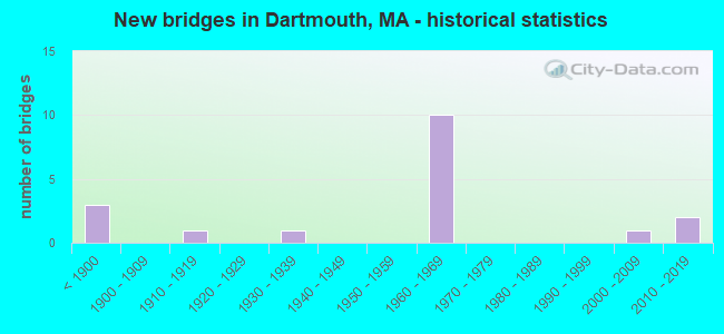
- New bridges - historical statistics
- 3Before 1900
- 11910-1919
- 11930-1939
- 101960-1969
- 12000-2009
- 22010-2019

- Reconstructed bridges - Historical Statistics
- 31930-1939
- 01940-1949
- 01950-1959
- 11960-1969
- 01970-1979
- 01980-1989
- 01990-1999
- 02000-2009
- 12010-2019


- Bridge Condition - Deck
- 22.2%Very good
- 11.1%Good
- 44.4%Satisfactory
- 22.2%Fair

- Bridge Condition - Superstructure
- 22.2%Very good
- 11.1%Good
- 22.2%Satisfactory
- 44.4%Fair

- Bridge Condition - Substructure
- 11.1%Very good
- 44.4%Good
- 33.3%Satisfactory
- 11.1%Fair

- Bridge Condition - Channel
- 25.0%Very good
- 62.5%Good
- 12.5%Satisfactory

- Bridge Condition - Culverts
- 33.3%Satisfactory
- 66.7%Fair
Find on map >> Show street view
Structure Number: D04001A3EMUNNBI, Location: 1 M W OF SMITH NECK RD (Lat: 41.535558, Lng: -70.969164), Route carried "on" structure: City street , Year Built: 2004, Status: Open, Structure Length: 2.56m (8.40ft), Average Daily Traffic: 650 (year 2019), Truck Traffic: 7%, Average Future Daily Traffic: 1,027 (year 2032), Design Load: HS 20, Features Intersected: WATER LITTLE RIVER, Facility Carried by Structure: HWY LTTLE RIV RD
Minimum Vertical Clearance: 30+ m (98+ ft), Kilometerpoint: 0.000, Lanes on structure: 2, Owner: Town or Township Highway Agency, Approaching Roadway Width: 7.3m (24.0ft), Material/Design: Prestressed concrete, Design/Construction: Box Beam or Girders - Single/Spread, Number Of Spans In Main Unit: 1, Length of Maximum Span: 24.9m (81.7ft), Curb or Sidewalk Widths: Left: 0.0m, Right: 1.9m (6.2ft), Curb-To-Curb Width: 7.3m (24.0ft), Out-to-Out Width: 9.7m (31.8ft)
Condition: Deck: Very good, Superstructure: Very good, Substructure: Very good, Channel: Very good, Inventory Rating: 77.3 metric tons, Method Used To Determine Inventory Rating: Load Factor (LF), Structural Evaluation: Equal to present desirable criteria, Deck Geometry: Meets minimum limits, Waterway Adequacy: Equal to present desirable criteria, Approach Roadway Alignment: Equal to present minimum criteria, Length Of Structure Improvement: 2.60m (8.53ft), Designated Inspection Frequency: Every 24 months, Inspection Date: January 2021, Bridge Improvement Cost: $1,198,000, Roadway Improvement Cost: $120,000, Total Project Cost: $1,798,000 ( Estimate for 2022), Deck Structure Type: Concrete Cast-file-Place, Wearing Surface/Protective System: Wearing Surface: Monolithic Concrete, Membrane: Built-up, Deck Protection: Epoxy Coated Reinforcing
Find on map >> Show street view
Structure Number: D040023J4MUNNBI, Location: 1.6 MI E OF TUCKER RD (Lat: 41.585900, Lng: -70.947542), Route carried "on" structure: City street , Year Built: 1935, Year Reconstructed: 1969, Status: Open, Structure Length: 12.77m (41.90ft), Average Daily Traffic: 9,500 (year 2019), Truck Traffic: 3%, Average Future Daily Traffic: 14,214 (year 2032), Design Load: H 15, Features Intersected: WATER APPONAGANSETT RIV, Facility Carried by Structure: HWY BRIDGE ST
Minimum Vertical Clearance: 30+ m (98+ ft), Kilometerpoint: 2.575, Lanes on structure: 2, Owner: Town or Township Highway Agency, Approaching Roadway Width: 9.1m (29.9ft), Navigation Control: Yes ( Vertical Clearance: 2.7m (8.9ft), Horizontal Clearance: 9.4m (30.8ft)), Material/Design: Steel, Design/Construction: Movable - Swing, Number Of Spans In Main Unit: 1, Number Of Approach Spans: 9, Length of Maximum Span: 31.4m (103.0ft), Curb or Sidewalk Widths: Left: 0.2m (0.7ft), Right: 1.5m (4.9ft), Curb-To-Curb Width: 9.1m (29.9ft), Out-to-Out Width: 12.2m (40.0ft)
Condition: Deck: Fair, Superstructure: Fair, Substructure: Fair, Channel: Satisfactory, Operating Rating: 42.5 metric tons, Method Used To Determine Operating Rating: Load Factor (LF), Inventory Rating: 25.4 metric tons, Method Used To Determine Inventory Rating: Load Factor (LF), Structural Evaluation: Somewhat better than minimum adequacy, Deck Geometry: Meets minimum limits, Waterway Adequacy: Equal to present desirable criteria, Approach Roadway Alignment: Somewhat better than minimum adequacy, Length Of Structure Improvement: 12.80m (41.99ft), Designated Inspection Frequency: Every 24 months, Critical Feature Inspection Frequency: Every 24 months, Underwater Inspection Frequency: Every 24 months, Inspection Date: May 2021, Critical Feature Inspection Date: May 2021, Underwater Inspection Date: July 2020, Bridge Improvement Cost: $6,134,000, Roadway Improvement Cost: $614,000, Total Project Cost: $9,202,000 ( Estimate for 2022), Deck Structure Type: Closed Grating, Wearing Surface/Protective System: Wearing Surface: Bituminous
Find on map >> Show street view
Structure Number: D040033NUDOTNBI, Location: .5 MI. WEST OF REED RD (Lat: 41.638703, Lng: -71.046981), Route carried "on" structure: US 6, Year Built: 1850, Year Reconstructed: 1937, Status: Open, Structure Length: 0.67m (2.20ft), Average Daily Traffic: 17,755 (year 2021), Truck Traffic: 9%, Average Future Daily Traffic: 39,482 (year 2032), Design Load: H 20, Features Intersected: WATER WESTPORT RIVER
Minimum Vertical Clearance: 30+ m (98+ ft), Kilometerpoint: 33.646, Lanes on structure: 5, Owner: State Highway Agency, Approaching Roadway Width: 26.8m (87.9ft), Skew: 20 degrees, Material/Design: Concrete, Design/Construction: Culvert, Number Of Spans In Main Unit: 1, Length of Maximum Span: 6.7m (22.0ft), Curb or Sidewalk Widths: Left: 1.9m (6.2ft), Right: 1.6m (5.2ft)
Condition: Channel: Good, Culverts: Fair, Operating Rating: 62.9 metric tons, Method Used To Determine Operating Rating: Allowable Stress (AS), Inventory Rating: 28.6 metric tons, Method Used To Determine Inventory Rating: Allowable Stress (AS), Structural Evaluation: Somewhat better than minimum adequacy, Waterway Adequacy: Equal to present desirable criteria, Approach Roadway Alignment: Equal to present desirable criteria, Length Of Structure Improvement: 2.70m (8.86ft), Designated Inspection Frequency: Every 24 months, Inspection Date: June 2021, Bridge Improvement Cost: $711,000, Roadway Improvement Cost: $72,000, Total Project Cost: $1,067,000 ( Estimate for 2022)
Find on map >> Show street view
Structure Number: D040043NVDOTNBI, Location: .5 MI. WEST OF REED RD (Lat: 41.638797, Lng: -71.047231), Route carried "on" structure: US 6, Year Built: 1850, Year Reconstructed: 1937, Status: Open, Structure Length: 0.70m (2.30ft), Average Daily Traffic: 17,755 (year 2021), Truck Traffic: 9%, Average Future Daily Traffic: 39,482 (year 2032), Features Intersected: WATER WESTPORT RIV SPL
Minimum Vertical Clearance: 30+ m (98+ ft), Kilometerpoint: 33.646, Lanes on structure: 5, Owner: State Highway Agency, Approaching Roadway Width: 26.8m (87.9ft), Skew: 20 degrees, Material/Design: Concrete, Design/Construction: Culvert, Number Of Spans In Main Unit: 1, Length of Maximum Span: 7.0m (23.0ft), Curb or Sidewalk Widths: Left: 1.9m (6.2ft), Right: 1.6m (5.2ft)
Condition: Channel: Good, Culverts: Fair, Inventory Rating: 62.9 metric tons, Method Used To Determine Inventory Rating: Load Factor (LF), Structural Evaluation: Somewhat better than minimum adequacy, Waterway Adequacy: Equal to present desirable criteria, Approach Roadway Alignment: Equal to present desirable criteria, Length Of Structure Improvement: 2.70m (8.86ft), Designated Inspection Frequency: Every 24 months, Inspection Date: June 2021, Bridge Improvement Cost: $744,000, Roadway Improvement Cost: $75,000, Total Project Cost: $1,117,000 ( Estimate for 2022)
Find on map >> Show street view
Structure Number: D04008AXCMUNNBI, Location: 1.1 MI E OF TUCKER RD (Lat: 41.582742, Lng: -70.957475), Route carried "on" structure: City street , Year Built: 2010, Status: Open, Structure Length: 3.90m (12.80ft), Average Daily Traffic: 4,272 (year 2019), Truck Traffic: 4%, Average Future Daily Traffic: 10,210 (year 2032), Design Load: HS 25 or greater, Features Intersected: WATER SW BR APPONAGANSET, Facility Carried by Structure: HWY GULF RD
Minimum Vertical Clearance: 30+ m (98+ ft), Kilometerpoint: 1.722, Lanes on structure: 2, Owner: Town or Township Highway Agency, Approaching Roadway Width: 7.3m (24.0ft), Navigation Control: Yes ( Vertical Clearance: 0.9m (3.0ft), Horizontal Clearance: 14.0m (45.9ft)), Material/Design: Prestressed concrete, Design/Construction: Box Beam or Girders - Single/Spread, Number Of Spans In Main Unit: 3, Length of Maximum Span: 15.0m (49.2ft), Curb or Sidewalk Widths: Left: 0.0m, Right: 1.8m (5.9ft), Curb-To-Curb Width: 9.6m (31.5ft), Out-to-Out Width: 12.8m (42.0ft)
Condition: Deck: Very good, Superstructure: Very good, Substructure: Good, Channel: Very good, Operating Rating: 70.0 metric tons, Method Used To Determine Operating Rating: Load Factor (LF), Inventory Rating: 49.6 metric tons, Method Used To Determine Inventory Rating: Load Factor (LF), Structural Evaluation: Better than present minimum criteria, Deck Geometry: Meets minimum limits, Waterway Adequacy: Equal to present minimum criteria, Approach Roadway Alignment: Equal to present minimum criteria, Length Of Structure Improvement: 4.00m (13.12ft), Designated Inspection Frequency: Every 24 months, Underwater Inspection Frequency: Every 36 months, Inspection Date: June 2021, Underwater Inspection Date: Febuary 2020, Bridge Improvement Cost: $1,434,000, Roadway Improvement Cost: $144,000, Total Project Cost: $2,152,000 ( Estimate for 2022), Deck Structure Type: Concrete Cast-file-Place, Wearing Surface/Protective System: Wearing Surface: Bituminous, Membrane: Preformed Fabric, Deck Protection: Epoxy Coated Reinforcing
Find on map >> Show street view
Structure Number: D040133X3DOTNBI, Location: 1.3 MI N OF US 6 (Lat: 41.657214, Lng: -71.036931), Route carried "on" structure: City street , Year Built: 1965, Status: Open, Structure Length: 7.86m (25.79ft), Average Daily Traffic: 11,379 (year 2021), Truck Traffic: 8%, Average Future Daily Traffic: 18,991 (year 2032), Design Load: H 20, Features Intersected: I 195, Facility Carried by Structure: HWY REED RD
Minimum Vertical Clearance: 30+ m (98+ ft), Kilometerpoint: 0.000, Lanes on structure: 2, Lanes under structure: 8, Owner: State Highway Agency, Approaching Roadway Width: 12.2m (40.0ft), Material/Design: Prestressed concrete, Design/Construction: Stringer/Multi-beam, Number Of Spans In Main Unit: 5, Length of Maximum Span: 19.5m (64.0ft), Curb or Sidewalk Widths: Left: 0.0m, Right: 1.5m (4.9ft), Curb-To-Curb Width: 12.2m (40.0ft), Out-to-Out Width: 15.0m (49.2ft)
Condition: Deck: Satisfactory, Superstructure: Fair, Substructure: Satisfactory, Operating Rating: 53.1 metric tons, Method Used To Determine Operating Rating: Load Factor (LF), Inventory Rating: 31.8 metric tons, Method Used To Determine Inventory Rating: Load Factor (LF), Structural Evaluation: Somewhat better than minimum adequacy, Deck Geometry: Somewhat better than minimum adequacy, Underclear: High priority of corrective action, Approach Roadway Alignment: Equal to present desirable criteria, Length Of Structure Improvement: 7.90m (25.92ft), Designated Inspection Frequency: Every 24 months, Inspection Date: September 2021, Bridge Improvement Cost: $4,655,000, Roadway Improvement Cost: $466,000, Total Project Cost: $6,983,000 ( Estimate for 2022), Deck Structure Type: Concrete Cast-file-Place, Wearing Surface/Protective System: Wearing Surface: Bituminous, Membrane: Built-up
Find on map >> Show street view
Structure Number: D040153X1DOTNBI, Location: .3 MI.W OF FAUNC CORNR RD (Lat: 41.655131, Lng: -70.998769), Route carried "on" structure: City street , Year Built: 1966, Status: Open, Structure Length: 7.99m (26.21ft), Average Daily Traffic: 6,853 (year 2021), Truck Traffic: 10%, Average Future Daily Traffic: 5,528 (year 2032), Design Load: H 20, Features Intersected: I 195, Facility Carried by Structure: HWY HIXVILLE RD
Minimum Vertical Clearance: 30+ m (98+ ft), Kilometerpoint: 0.000, Lanes on structure: 2, Lanes under structure: 6, Owner: State Highway Agency, Approaching Roadway Width: 9.8m (32.2ft), Skew: 2 degrees, Material/Design: Prestressed concrete, Design/Construction: Stringer/Multi-beam, Number Of Spans In Main Unit: 5, Length of Maximum Span: 20.1m (65.9ft), Curb or Sidewalk Widths: Left: 2.0m (6.6ft), Right: 0.9m (3.0ft), Curb-To-Curb Width: 9.8m (32.2ft), Out-to-Out Width: 12.6m (41.3ft)
Condition: Deck: Satisfactory, Superstructure: Satisfactory, Substructure: Good, Operating Rating: 49.2 metric tons, Method Used To Determine Operating Rating: Allowable Stress (AS), Inventory Rating: 34.2 metric tons, Method Used To Determine Inventory Rating: Allowable Stress (AS), Structural Evaluation: Equal to present minimum criteria, Deck Geometry: Meets minimum limits, Underclear: High priority of corrective action, Approach Roadway Alignment: Equal to present desirable criteria, Length Of Structure Improvement: 8.00m (26.25ft), Designated Inspection Frequency: Every 24 months, Inspection Date: November 2021, Bridge Improvement Cost: $2,716,000, Roadway Improvement Cost: $272,000, Total Project Cost: $4,075,000 ( Estimate for 2022), Deck Structure Type: Concrete Cast-file-Place, Wearing Surface/Protective System: Wearing Surface: Bituminous, Membrane: Built-up
Find on map >> Show street view
Structure Number: D04016BEQDOTNBI, Location: .7 MI.N OF US 6 (Lat: 41.654900, Lng: -70.987894), Route carried "on" structure: City street , Year Built: 2017, Status: Open, Structure Length: 7.76m (25.46ft), Average Daily Traffic: 18,800 (year 2019), Truck Traffic: 4%, Design Load: HL 93, Features Intersected: I 195, Facility Carried by Structure: HWY FNCE CRNR RD
Minimum Vertical Clearance: 30+ m (98+ ft), Kilometerpoint: 0.000, Lanes on structure: 5, Lanes under structure: 8, Owner: State Highway Agency, Approaching Roadway Width: 23.7m (77.8ft), Skew: 21 degrees, Material/Design: Prestressed concrete continuous, Design/Construction: Stringer/Multi-beam, Number Of Spans In Main Unit: 2, Length of Maximum Span: 36.0m (118.1ft), Curb or Sidewalk Widths: Left: 1.8m (5.9ft), Right: 3.5m (11.5ft), Curb-To-Curb Width: 23.8m (78.1ft), Out-to-Out Width: 35.1m (115.2ft)
Condition: Deck: Good, Superstructure: Good, Substructure: Good, Operating Rating: 42.1 metric tons, Method Used To Determine Operating Rating: Load and Resistance Factor Rating (LRFR) rating reported by rating factor(RF) method using HL-93 loadings, Inventory Rating: 32.4 metric tons, Method Used To Determine Inventory Rating: Load and Resistance Factor Rating (LRFR) rating reported by rating factor(RF) method using HL-93 loadings, Structural Evaluation: Better than present minimum criteria, Deck Geometry: Better than present minimum criteria, Underclear: Superior to present desirable criteria, Approach Roadway Alignment: Equal to present desirable criteria, Designated Inspection Frequency: Every 24 months, Inspection Date: July 2021, Deck Structure Type: Concrete Cast-file-Place, Wearing Surface/Protective System: Wearing Surface: Bituminous, Membrane: Built-up, Deck Protection: Epoxy Coated Reinforcing
Find on map >> Show street view
Structure Number: D040183L6MUNNBI, Location: 0.1 MI S OF TANNERY LANE (Lat: 41.571039, Lng: -71.004650), Route carried "on" structure: City street , Year Built: 1962, Year Reconstructed: 2016, Status: Open, Structure Length: 0.72m (2.36ft), Average Daily Traffic: 4,008 (year 2018), Truck Traffic: 10%, Average Future Daily Traffic: 8,844 (year 2031), Features Intersected: WATER PASKAMANSETT RIVER, Facility Carried by Structure: HWY RCK DNDEE RD
Minimum Vertical Clearance: 30+ m (98+ ft), Kilometerpoint: 5.375, Lanes on structure: 2, Owner: Town or Township Highway Agency, Approaching Roadway Width: 9.7m (31.8ft), Skew: 1 degrees, Material/Design: Steel, Design/Construction: Culvert, Number Of Spans In Main Unit: 2, Length of Maximum Span: 3.3m (10.8ft), Curb-To-Curb Width: 9.3m (30.5ft), Out-to-Out Width: 18.8m (61.7ft)
Condition: Channel: Good, Culverts: Satisfactory, Structural Evaluation: Equal to present minimum criteria, Deck Geometry: Meets minimum limits, Waterway Adequacy: Equal to present minimum criteria, Approach Roadway Alignment: Equal to present desirable criteria, Designated Inspection Frequency: Every 24 months, Inspection Date: June 2020
Find on map >> Show street view
Structure Number: D040203J5MUNNBI, Location: .75 M W OF TUCKER RD (Lat: 41.585711, Lng: -70.990133), Route carried "on" structure: City street , Year Built: 1826, Year Reconstructed: 1936, Status: Posted for load, Structure Length: 0.88m (2.89ft), Average Daily Traffic: 13,200 (year 2018), Truck Traffic: 11%, Average Future Daily Traffic: 11,371 (year 2031), Features Intersected: WATER PASKAMANSETT RIVER, Facility Carried by Structure: HWY RUSSELLS MIL
Minimum Vertical Clearance: 30+ m (98+ ft), Kilometerpoint: 2.350, Lanes on structure: 2, Owner: Town or Township Highway Agency, Approaching Roadway Width: 9.1m (29.9ft), Material/Design: Masonry, Design/Construction: Arch - Deck, Number Of Spans In Main Unit: 2, Length of Maximum Span: 3.7m (12.1ft), Curb or Sidewalk Widths: Left: 1.8m (5.9ft), Right: 0.0m, Curb-To-Curb Width: 9.1m (29.9ft), Out-to-Out Width: 16.8m (55.1ft)
Condition: Deck: Satisfactory, Superstructure: Fair, Substructure: Satisfactory, Channel: Good, Operating Rating: 39.0 metric tons, Method Used To Determine Operating Rating: Load Factor (LF), Inventory Rating: 23.4 metric tons, Method Used To Determine Inventory Rating: Load Factor (LF), Structural Evaluation: Somewhat better than minimum adequacy, Deck Geometry: High priority of corrective action, Waterway Adequacy: Superior to present desirable criteria, Approach Roadway Alignment: Better than present minimum criteria, Length Of Structure Improvement: 0.90m (2.95ft), Designated Inspection Frequency: Every 24 months, Inspection Date: September 2020, Bridge Improvement Cost: $594,000, Roadway Improvement Cost: $60,000, Total Project Cost: $892,000 ( Estimate for 2022)
Find on map >> Show street view
Structure Number: D040223J3MUNNBI, Location: .6 MI SE OF REED RD (Lat: 41.669986, Lng: -71.025136), Route carried "on" structure: City street , Year Built: 1910, Status: Open, Structure Length: 0.98m (3.22ft), Average Daily Traffic: 2,900 (year 2018), Truck Traffic: 5%, Average Future Daily Traffic: 4,422 (year 2031), Features Intersected: WATER SHINGLE ISL RIVER, Facility Carried by Structure: HWY HIXVILLE RD
Minimum Vertical Clearance: 30+ m (98+ ft), Kilometerpoint: 4.667, Lanes on structure: 2, Owner: Town or Township Highway Agency, Approaching Roadway Width: 7.0m (23.0ft), Material/Design: Concrete continuous, Design/Construction: Slab, Number Of Spans In Main Unit: 3, Length of Maximum Span: 2.4m (7.9ft), Curb-To-Curb Width: 7.8m (25.6ft), Out-to-Out Width: 8.9m (29.2ft)
Condition: Deck: Fair, Superstructure: Fair, Substructure: Satisfactory, Channel: Good, Operating Rating: 65.6 metric tons, Method Used To Determine Operating Rating: Load Factor (LF), Inventory Rating: 39.3 metric tons, Method Used To Determine Inventory Rating: Load Factor (LF), Structural Evaluation: Somewhat better than minimum adequacy, Deck Geometry: High priority of replacement, Waterway Adequacy: Equal to present minimum criteria, Approach Roadway Alignment: Equal to present desirable criteria, Length Of Structure Improvement: 1.00m (3.28ft), Designated Inspection Frequency: Every 24 months, Inspection Date: September 2020, Bridge Improvement Cost: $350,000, Roadway Improvement Cost: $36,000, Total Project Cost: $526,000 ( Estimate for 2022), Deck Structure Type: Concrete Cast-file-Place, Wearing Surface/Protective System: Wearing Surface: Bituminous
Find on map >> Show street view
Structure Number: W300273YHDOTNBI, Location: .6 MI E OF ST 88 (Lat: 41.672633, Lng: -71.088058), Route carried "on" structure: City street , Year Built: 1965, Status: Open, Structure Length: 10.45m (34.28ft), Average Daily Traffic: 1,200 (year 2021), Truck Traffic: 11%, Average Future Daily Traffic: 3,317 (year 2032), Design Load: H 20, Features Intersected: I 195, Facility Carried by Structure: HWY DAVIS RD
Minimum Vertical Clearance: 30+ m (98+ ft), Kilometerpoint: 0.000, Lanes on structure: 2, Lanes under structure: 7, Owner: State Highway Agency, Approaching Roadway Width: 9.8m (32.2ft), Skew: 4 degrees, Material/Design: Steel, Design/Construction: Stringer/Multi-beam, Number Of Spans In Main Unit: 5, Length of Maximum Span: 27.2m (89.2ft), Curb or Sidewalk Widths: Left: 0.6m (2.0ft), Right: 1.6m (5.2ft), Curb-To-Curb Width: 9.8m (32.2ft), Out-to-Out Width: 12.5m (41.0ft)
Condition: Deck: Satisfactory, Superstructure: Satisfactory, Substructure: Good, Operating Rating: 80.4 metric tons, Method Used To Determine Operating Rating: Load Factor (LF), Inventory Rating: 48.3 metric tons, Method Used To Determine Inventory Rating: Load Factor (LF), Structural Evaluation: Equal to present minimum criteria, Deck Geometry: Somewhat better than minimum adequacy, Underclear: High priority of corrective action, Approach Roadway Alignment: Equal to present desirable criteria, Length Of Structure Improvement: 10.50m (34.45ft), Designated Inspection Frequency: Every 24 months, Inspection Date: Febuary 2021, Bridge Improvement Cost: $3,564,000, Roadway Improvement Cost: $357,000, Total Project Cost: $5,347,000 ( Estimate for 2022), Deck Structure Type: Concrete Cast-file-Place, Wearing Surface/Protective System: Wearing Surface: Bituminous, Membrane: Built-up
Find on map >> Show street view
Structure Number: D040133X3DOTNBI, Location: .7 MI.N OF US 6 (Lat: 41.650000, Lng: -71.033333), Route carried "under" structure: Interstate 195, Year Built: 1965, Structure Length: 0. m, Average Daily Traffic: 33,369 (year 0000), Features Intersected: I 195 EB, Facility Carried by Structure: HWY REED RD
Minimum Vertical Clearance: 4.47m (14.67ft), Kilometerpoint: 0.000, Lanes on structure: 4, Lanes under structure: 2, Material/Design: Prestressed concrete, Design/Construction: Stringer/Multi-beam, Length of Maximum Span: 19.5m (64.0ft)
Find on map >> Show street view
Structure Number: D040133X3DOTNBI, Location: 000065 STATUTORY (Lat: 41.650000, Lng: -71.033333), Route carried "under" structure: Interstate 195, Year Built: 1965, Structure Length: 0. m, Average Daily Traffic: 33,369 (year 0000), Features Intersected: I 195 WB, Facility Carried by Structure: HWY REED RD
Minimum Vertical Clearance: 4.47m (14.67ft), Kilometerpoint: 0.000, Lanes on structure: 4, Lanes under structure: 2, Material/Design: Prestressed concrete, Design/Construction: Stringer/Multi-beam, Length of Maximum Span: 19.5m (64.0ft)
Find on map >> Show street view
Structure Number: D040153X1DOTNBI, Location: .3 MI.W OF FAUNC CORNR RD (Lat: 41.650000, Lng: -71.000000), Route carried "under" structure: Interstate 195, Year Built: 1966, Structure Length: 0. m, Average Daily Traffic: 33,369 (year 0000), Features Intersected: I 195 EB, Facility Carried by Structure: HWY HIXVILLE RD
Minimum Vertical Clearance: 4.44m (14.57ft), Kilometerpoint: 0.000, Lanes on structure: 4, Lanes under structure: 2, Material/Design: Concrete, Design/Construction: Stringer/Multi-beam, Length of Maximum Span: 20.1m (65.9ft)
Find on map >> Show street view
Structure Number: D040153X1DOTNBI, Location: 000066 STATUTORY (Lat: 41.650000, Lng: -71.000000), Route carried "under" structure: Interstate 195, Year Built: 1966, Structure Length: 0. m, Average Daily Traffic: 33,369 (year 0000), Features Intersected: I 195 WB, Facility Carried by Structure: HWY HIXVILLE RD
Minimum Vertical Clearance: 4.44m (14.57ft), Kilometerpoint: 0.000, Lanes on structure: 4, Lanes under structure: 2, Material/Design: Concrete, Design/Construction: Stringer/Multi-beam, Length of Maximum Span: 20.1m (65.9ft)
Find on map >> Show street view
Structure Number: W300273YHDOTNBI, Location: .1 MI.E OF ST 88 (Lat: 41.666667, Lng: -71.083333), Route carried "under" structure: Interstate 195, Year Built: 1965, Structure Length: 0. m, Average Daily Traffic: 33,369 (year 0000), Features Intersected: I 195 EB, Facility Carried by Structure: HWY HIGHLAND AVE.
Minimum Vertical Clearance: 4.47m (14.67ft), Kilometerpoint: 0.000, Lanes on structure: 4, Lanes under structure: 2, Material/Design: Steel, Design/Construction: Stringer/Multi-beam, Length of Maximum Span: 28.0m (91.9ft)
Find on map >> Show street view
Structure Number: W300273YHDOTNBI, Location: 000065 STATUTORY (Lat: 41.666667, Lng: -71.083333), Route carried "under" structure: Interstate 195, Year Built: 1965, Structure Length: 0. m, Average Daily Traffic: 33,369 (year 0000), Features Intersected: I 195 WB, Facility Carried by Structure: HWY HIGHLAND AVE.
Minimum Vertical Clearance: 4.47m (14.67ft), Kilometerpoint: 0.000, Lanes on structure: 4, Lanes under structure: 2, Material/Design: Steel, Design/Construction: Stringer/Multi-beam, Length of Maximum Span: 28.0m (91.9ft)