Bridge Statistics for Decatur, Georgia (GA)
Condition, Traffic, Stress, Structural Evaluation, Project Costs
- National Bridge Inventory (NBI) Statistics
- 19Number of bridges
- 69ft / 20.9mTotal length
- $6,252,000Total costs
- 185,032Total average daily traffic
- 2,474Total average daily truck traffic
- National Bridge Inventory (NBI) Registered Bridges for Decatur
- No street view available for this location
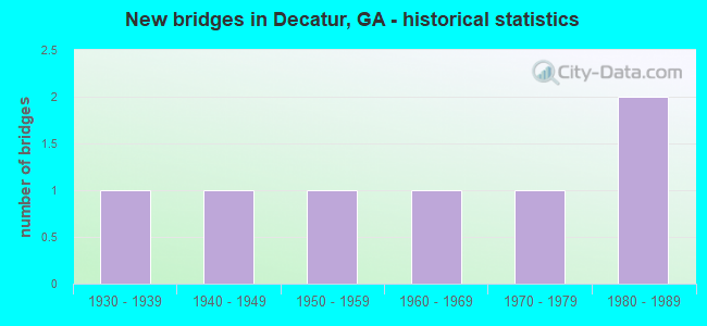
- New bridges - historical statistics
- 11930-1939
- 11940-1949
- 11950-1959
- 11960-1969
- 11970-1979
- 21980-1989


- Bridge Condition - Deck
- 20.0%Very good
- 80.0%Good

- Bridge Condition - Superstructure
- 40.0%Very good
- 40.0%Good
- 20.0%Fair

- Bridge Condition - Substructure
- 80.0%Good
- 20.0%Satisfactory

- Bridge Condition - Channel
- 50.0%Good
- 50.0%Satisfactory
Find on map >> Show street view
Structure Number: 890007, Location: IN DECATUR (Lat: 33.764978, Lng: -84.311489), Route carried "on" structure: US 278, Year Built: 1980, Status: Open, Structure Length: 2.23m (7.32ft), Average Daily Traffic: 9,390 (year 2011), Truck Traffic: 1%, Average Future Daily Traffic: 14,085 (year 2031), Design Load: HS 20+Mod, Features Intersected: SR 10 (US 278)
Minimum Vertical Clearance: 30+ m (98+ ft), Kilometerpoint: 1.609, Lanes on structure: 3, Lanes under structure: 4, Base Highway Network: Yes, Owner: State Highway Agency, Approaching Roadway Width: 10.4m (34.1ft), Material/Design: Steel, Design/Construction: Stringer/Multi-beam, Number Of Spans In Main Unit: 1, Length of Maximum Span: 22.3m (73.2ft), Curb or Sidewalk Widths: Left: 1.5m (4.9ft), Right: 3.0m (9.8ft), Curb-To-Curb Width: 19.5m (64.0ft), Out-to-Out Width: 24.8m (81.4ft)
Condition: Deck: Good, Superstructure: Very good, Substructure: Good, Operating Rating: 55.3 metric tons, Method Used To Determine Operating Rating: Allowable Stress (AS), Inventory Rating: 32.6 metric tons, Method Used To Determine Inventory Rating: Allowable Stress (AS), Structural Evaluation: Better than present minimum criteria, Deck Geometry: Superior to present desirable criteria, Underclear: Meets minimum limits, Approach Roadway Alignment: Equal to present desirable criteria, Designated Inspection Frequency: Every 24 months, Inspection Date: April 2020, Bridge Improvement Cost: $363,000, Roadway Improvement Cost: $36,000, Total Project Cost: $545,000, Deck Structure Type: Concrete Cast-file-Place
Find on map >> Show street view
Structure Number: 890134, Location: 1.5 MI NW OF DECATUR (Lat: 33.790758, Lng: -84.307789), Route carried "on" structure: City street 9011, Year Built: 1958, Status: Open, Structure Length: 3.51m (11.52ft), Average Daily Traffic: 16,130 (year 2012), Truck Traffic: 1%, Average Future Daily Traffic: 24,195 (year 2032), Design Load: H 15, Features Intersected: CSX RAILROAD, Facility Carried by Structure: NORTH DECATUR RD
Minimum Vertical Clearance: 30+ m (98+ ft), Kilometerpoint: 4.828, Lanes on structure: 4, Base Highway Network: Yes, Owner: County Highway Agency, Approaching Roadway Width: 14.6m (47.9ft), Material/Design: Steel continuous, Design/Construction: Stringer/Multi-beam, Number Of Spans In Main Unit: 3, Length of Maximum Span: 13.1m (43.0ft), Curb or Sidewalk Widths: Left: 1.5m (4.9ft), Right: 1.5m (4.9ft), Curb-To-Curb Width: 14.6m (47.9ft), Out-to-Out Width: 18.3m (60.0ft)
Condition: Deck: Good, Superstructure: Fair, Substructure: Satisfactory, Operating Rating: 35.3 metric tons, Method Used To Determine Operating Rating: Load Factor (LF), Inventory Rating: 20.8 metric tons, Method Used To Determine Inventory Rating: Load Factor (LF), Structural Evaluation: Somewhat better than minimum adequacy, Deck Geometry: High priority of replacement, Underclear: Meets minimum limits, Approach Roadway Alignment: Equal to present desirable criteria, Length Of Structure Improvement: 9.94m (32.61ft), Designated Inspection Frequency: Every 24 months, Other Special Inspection Frequency: Every 12 months, Inspection Date: July 2020, Other Special Inspection Date: July 2021, Bridge Improvement Cost: $694,000, Roadway Improvement Cost: $69,000, Total Project Cost: $1,042,000, Deck Structure Type: Concrete Cast-file-Place, Wearing Surface/Protective System: Wearing Surface: Bituminous
Find on map >> Show street view
Structure Number: 890135, Location: 1.1 MI N OF DECATUR (Lat: 33.790878, Lng: -84.300758), Route carried "on" structure: City street 9011, Year Built: 1937, Status: Open, Structure Length: 0.73m (2.40ft), Average Daily Traffic: 19,680 (year 2011), Truck Traffic: 1%, Average Future Daily Traffic: 29,520 (year 2031), Design Load: H 15, Features Intersected: S FORK P'TREE CRK TRIB, Facility Carried by Structure: NORTH DECATUR RD
Minimum Vertical Clearance: 30+ m (98+ ft), Kilometerpoint: 4.828, Lanes on structure: 4, Base Highway Network: Yes, Owner: County Highway Agency, Approaching Roadway Width: 11.6m (38.1ft), Material/Design: Steel, Design/Construction: Culvert, Number Of Spans In Main Unit: 2, Length of Maximum Span: 3.7m (12.1ft), Curb or Sidewalk Widths: Left: 0.9m (3.0ft), Right: 0.0m
Condition: Channel: Satisfactory, Culverts: Good, Operating Rating: 41.7 metric tons, Method Used To Determine Operating Rating: Field evaluation and documented engineering judgment, Inventory Rating: 24.4 metric tons, Method Used To Determine Inventory Rating: Field evaluation and documented engineering judgment, Structural Evaluation: Equal to present minimum criteria, Waterway Adequacy: Equal to present minimum criteria, Approach Roadway Alignment: Equal to present desirable criteria, Designated Inspection Frequency: Every 24 months, Inspection Date: June 2020, Bridge Improvement Cost: $145,000, Roadway Improvement Cost: $14,000, Total Project Cost: $217,000
Find on map >> Show street view
Structure Number: 890165, Location: IN DECATUR (Lat: 33.765489, Lng: -84.311589), Route carried "on" structure: City street 9332, Year Built: 1980, Status: Open, Structure Length: 2.32m (7.61ft), Average Daily Traffic: 12,290 (year 2011), Truck Traffic: 1%, Average Future Daily Traffic: 18,435 (year 2031), Design Load: HS 20+Mod, Features Intersected: SR 10 EAST LAKE DRIVE, Facility Carried by Structure: HOWARD AVE
Minimum Vertical Clearance: 30+ m (98+ ft), Kilometerpoint: 3.219, Lanes on structure: 4, Lanes under structure: 4, Base Highway Network: Yes, Owner: State Highway Agency, Approaching Roadway Width: 13.7m (44.9ft), Material/Design: Steel, Design/Construction: Stringer/Multi-beam, Number Of Spans In Main Unit: 1, Length of Maximum Span: 23.2m (76.1ft), Curb or Sidewalk Widths: Left: 2.4m (7.9ft), Right: 2.7m (8.9ft), Curb-To-Curb Width: 14.0m (45.9ft), Out-to-Out Width: 19.9m (65.3ft)
Condition: Deck: Good, Superstructure: Very good, Substructure: Good, Operating Rating: 55.3 metric tons, Method Used To Determine Operating Rating: Allowable Stress (AS), Inventory Rating: 32.6 metric tons, Method Used To Determine Inventory Rating: Allowable Stress (AS), Structural Evaluation: Better than present minimum criteria, Deck Geometry: High priority of replacement, Underclear: Meets minimum limits, Approach Roadway Alignment: Equal to present desirable criteria, Designated Inspection Frequency: Every 24 months, Inspection Date: April 2020, Bridge Improvement Cost: $459,000, Roadway Improvement Cost: $46,000, Total Project Cost: $688,000, Deck Structure Type: Concrete Cast-file-Place
Find on map >> Show street view
Structure Number: 890166, Location: 4.5 MI SE OF DECATUR (Lat: 33.716189, Lng: -84.344719), Route carried "on" structure: City street 9173, Year Built: 1960, Status: Open, Structure Length: 1.34m (4.40ft), Average Daily Traffic: 7,170 (year 2011), Truck Traffic: 4%, Average Future Daily Traffic: 10,755 (year 2031), Design Load: H 15, Features Intersected: ENTRENCHMENT CREEK, Facility Carried by Structure: CUSTER AVE.
Minimum Vertical Clearance: 30+ m (98+ ft), Kilometerpoint: 0.000, Lanes on structure: 2, Base Highway Network: Yes, Owner: County Highway Agency, Approaching Roadway Width: 9.1m (29.9ft), Material/Design: Concrete, Design/Construction: Culvert, Number Of Spans In Main Unit: 4, Length of Maximum Span: 3.0m (9.8ft), Curb or Sidewalk Widths: Left: 0.0m, Right: 1.2m (3.9ft)
Condition: Channel: Good, Culverts: Good, Operating Rating: 43.5 metric tons, Method Used To Determine Operating Rating: Field evaluation and documented engineering judgment, Inventory Rating: 24.4 metric tons, Method Used To Determine Inventory Rating: Field evaluation and documented engineering judgment, Structural Evaluation: Equal to present minimum criteria, Waterway Adequacy: Equal to present desirable criteria, Approach Roadway Alignment: Equal to present desirable criteria, Designated Inspection Frequency: Every 24 months, Inspection Date: April 2020, Bridge Improvement Cost: $172,000, Roadway Improvement Cost: $17,000, Total Project Cost: $258,000
Find on map >> Show street view
Structure Number: 890185, Location: IN ATLANTA CITY LIMITS (Lat: 33.748428, Lng: -84.309789), Route carried "on" structure: City street 9232, Year Built: 1945, Status: Open, Structure Length: 1.58m (5.18ft), Average Daily Traffic: 6,850 (year 2011), Truck Traffic: 1%, Average Future Daily Traffic: 10,275 (year 2031), Design Load: H 15, Features Intersected: CR2733 COTTAGE GROVE AVE, Facility Carried by Structure: SECOND AVE.
Minimum Vertical Clearance: 30+ m (98+ ft), Kilometerpoint: 3.219, Lanes on structure: 2, Lanes under structure: 2, Base Highway Network: Yes, Owner: County Highway Agency, Approaching Roadway Width: 9.4m (30.8ft), Skew: 1 degrees, Material/Design: Concrete, Design/Construction: Slab, Number Of Spans In Main Unit: 1, Length of Maximum Span: 15.8m (51.8ft), Curb or Sidewalk Widths: Left: 2.4m (7.9ft), Right: 2.4m (7.9ft), Curb-To-Curb Width: 9.7m (31.8ft), Out-to-Out Width: 14.9m (48.9ft)
Condition: Deck: Very good, Superstructure: Good, Substructure: Good, Operating Rating: 57.1 metric tons, Method Used To Determine Operating Rating: Allowable Stress (AS), Inventory Rating: 16.3 metric tons, Method Used To Determine Inventory Rating: Allowable Stress (AS), Structural Evaluation: Meets minimum limits, Deck Geometry: High priority of corrective action, Underclear: High priority of replacement, Approach Roadway Alignment: Equal to present desirable criteria, Length Of Structure Improvement: 8.02m (26.31ft), Designated Inspection Frequency: Every 24 months, Inspection Date: May 2020, Bridge Improvement Cost: $203,000, Roadway Improvement Cost: $20,000, Total Project Cost: $305,000, Deck Structure Type: Concrete Cast-file-Place, Wearing Surface/Protective System: Wearing Surface: Bituminous
Find on map >> Show street view
Structure Number: 890262, Location: 1 MI E OF DECATUR (Lat: 33.775900, Lng: -84.280050), Route carried "on" structure: City street 9228, Year Built: 1979, Status: Open, Structure Length: 9.14m (29.99ft), Average Daily Traffic: 14,890 (year 2011), Truck Traffic: 1%, Average Future Daily Traffic: 22,335 (year 2031), Design Load: HS 20+Mod, Features Intersected: MARTA- CSX RAILROAD, Facility Carried by Structure: ARCADIA AVE./SAMS
Minimum Vertical Clearance: 30+ m (98+ ft), Kilometerpoint: 1.609, Lanes on structure: 5, Lanes under structure: 2, Base Highway Network: Yes, Owner: Private, Approaching Roadway Width: 15.8m (51.8ft), Material/Design: Steel continuous, Design/Construction: Stringer/Multi-beam, Number Of Spans In Main Unit: 3, Length of Maximum Span: 33.5m (109.9ft), Curb or Sidewalk Widths: Left: 1.5m (4.9ft), Right: 1.5m (4.9ft), Curb-To-Curb Width: 15.9m (52.2ft), Out-to-Out Width: 20.4m (66.9ft)
Condition: Deck: Good, Superstructure: Good, Substructure: Good, Operating Rating: 46.2 metric tons, Method Used To Determine Operating Rating: Allowable Stress (AS), Inventory Rating: 32.6 metric tons, Method Used To Determine Inventory Rating: Allowable Stress (AS), Structural Evaluation: Better than present minimum criteria, Deck Geometry: High priority of replacement, Underclear: High priority of corrective action, Approach Roadway Alignment: Equal to present minimum criteria, Designated Inspection Frequency: Every 24 months, Inspection Date: April 2020, Bridge Improvement Cost: $2,131,000, Roadway Improvement Cost: $213,000, Total Project Cost: $3,197,000, Deck Structure Type: Concrete Cast-file-Place
Find on map >> Show street view
Structure Number: 890007, Location: IN DECATUR (Lat: 33.764978, Lng: -84.311489), Route carried "under" structure: US 278, Structure Length: 0. m, Average Daily Traffic: 3,600 (year 1999), Truck Traffic: 1%, Features Intersected: SR 10 (US 278)
Minimum Vertical Clearance: 5.48m (17.98ft), Kilometerpoint: 1.609, Lanes on structure: 3, Length of Maximum Span: 0.0m
Find on map >> Show street view
Structure Number: 890165, Location: IN DECATUR (Lat: 33.765489, Lng: -84.311589), Route carried "under" structure: US 278, Structure Length: 0. m, Average Daily Traffic: 3,600 (year 1999), Truck Traffic: 1%, Features Intersected: M-9332 HOWARD AVENUE, Facility Carried by Structure: HOWARD AVE
Minimum Vertical Clearance: 8.02m (26.31ft), Kilometerpoint: 1.609, Lanes on structure: 4, Length of Maximum Span: 0.0m
Find on map >> Show street view
Structure Number: 890185, Location: IN ATLANTA CITY LIMITS (Lat: 33.748428, Lng: -84.309789), Route carried "under" structure: City street 2733, Structure Length: 0. m, Average Daily Traffic: 1,820 (year 1999), Truck Traffic: 1%, Features Intersected: M-9232 SECOND AVE., Facility Carried by Structure: SECOND AVE.
Minimum Vertical Clearance: 4.03m (13.22ft), Kilometerpoint: 0.000, Lanes on structure: 2, Length of Maximum Span: 0.0m
Find on map >> Show street view
Structure Number: 890235, Location: IN DECATUR (Lat: 33.765358, Lng: -84.311558), Route carried "under" structure: US 278, Structure Length: 0. m, Average Daily Traffic: 4,740 (year 2011), Truck Traffic: 2%, Features Intersected: SR 10 EAST LAKE DRIVE, Facility Carried by Structure: MARTA WB LINE
Minimum Vertical Clearance: 7.82m (25.66ft), Kilometerpoint: 1.609, Length of Maximum Span: 0.0m
Find on map >> Show street view
Structure Number: 890236, Location: IN DECATUR (Lat: 33.765258, Lng: -84.311547), Route carried "under" structure: US 278, Structure Length: 0. m, Average Daily Traffic: 4,740 (year 2011), Truck Traffic: 2%, Features Intersected: SR 10 EAST LAKE DRIVE, Facility Carried by Structure: MARTA EB LINE
Minimum Vertical Clearance: 7.46m (24.48ft), Kilometerpoint: 1.609, Length of Maximum Span: 0.0m
Find on map >> Show street view
Structure Number: 890237, Location: IN DECATUR (Lat: 33.765169, Lng: -84.311458), Route carried "under" structure: US 278, Structure Length: 0. m, Average Daily Traffic: 4,740 (year 2011), Truck Traffic: 2%, Features Intersected: SR 10 EAST LAKE DRIVE, Facility Carried by Structure: CSX RAILROAD
Minimum Vertical Clearance: 5.18m (16.99ft), Kilometerpoint: 1.609, Length of Maximum Span: 0.0m
Find on map >> Show street view
Structure Number: 890241, Location: IN SOUTH DECATUR (Lat: 33.772839, Lng: -84.287989), Route carried "under" structure: State highway 155, Structure Length: 0. m, Average Daily Traffic: 12,210 (year 2011), Truck Traffic: 1%, Features Intersected: SR 155 CLAIRMONT AVE., Facility Carried by Structure: CSX RAILROAD
Minimum Vertical Clearance: 4.29m (14.07ft), Kilometerpoint: 20.921, Length of Maximum Span: 0.0m
Find on map >> Show street view
Structure Number: 890253, Location: IN DECATUR (Lat: 33.764878, Lng: -84.313133), Route carried "under" structure: State highway 10, Structure Length: 0. m, Average Daily Traffic: 9,390 (year 2011), Truck Traffic: 1%, Features Intersected: SR 10 COLLEGE AVE., Facility Carried by Structure: MARTA PED.
Minimum Vertical Clearance: 6.40m (21.00ft), Kilometerpoint: 1.609, Length of Maximum Span: 0.0m
Find on map >> Show street view
Structure Number: 890254, Location: IN DECATUR (Lat: 33.774692, Lng: -84.282153), Route carried "under" structure: State highway 10, Structure Length: 0. m, Average Daily Traffic: 22,310 (year 2011), Truck Traffic: 3%, Features Intersected: SR 10, Facility Carried by Structure: MARTA PED.
Minimum Vertical Clearance: 5.41m (17.75ft), Kilometerpoint: 4.828, Length of Maximum Span: 0.0m
Find on map >> Show street view
Structure Number: 890262, Location: 1 MI E OF DECATUR (Lat: 33.775900, Lng: -84.280050), Route carried "under" structure: County highway 9228, Structure Length: 0. m, Average Daily Traffic: 16,990 (year 2006), Features Intersected: GA R/R & MARTA, Facility Carried by Structure: ARCADIA AVE./SAMS
Minimum Vertical Clearance: 30+ m (98+ ft), Kilometerpoint: 3.219, Lanes on structure: 5, Length of Maximum Span: 0.0m
Find on map >> Show street view
Structure Number: 890266, Location: IN DECATUR (Lat: 33.765397, Lng: -84.313147), Route carried "under" structure: City street 9332, Structure Length: 0. m, Average Daily Traffic: 12,290 (year 2011), Truck Traffic: 1%, Features Intersected: M-9332 DEKALB AVE., Facility Carried by Structure: MARTA PED O/PASS
Minimum Vertical Clearance: 4.92m (16.14ft), Kilometerpoint: 3.219, Length of Maximum Span: 0.0m
Find on map >> Show street view
Structure Number: 895092, Location: IN DECATUR CITY LIMITS (Lat: 33.773539, Lng: -84.302119), Route carried "under" structure: City street 2094, Structure Length: 0. m, Average Daily Traffic: 2,202 (year 2011), Truck Traffic: 1%, Features Intersected: CR 2094 W. TRINITY PLACE, Facility Carried by Structure: MARTA
Minimum Vertical Clearance: 4.67m (15.32ft), Kilometerpoint: 0.000, Length of Maximum Span: 0.0m