Bridge Statistics for Denmark, South Carolina (SC)
Condition, Traffic, Stress, Structural Evaluation, Project Costs
- National Bridge Inventory (NBI) Statistics
- 13Number of bridges
- 59ft / 18.2mTotal length
- $284,000Total costs
- 8,850Total average daily traffic
- 716Total average daily truck traffic
- 12,837Total future (year 2040) average daily traffic
- National Bridge Inventory (NBI) Registered Bridges for Denmark
- No street view available for this location
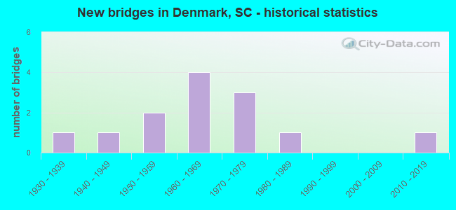
- New bridges - historical statistics
- 11930-1939
- 11940-1949
- 21950-1959
- 41960-1969
- 31970-1979
- 11980-1989
- 12010-2019

- Reconstructed bridges - Historical Statistics
- 11970-1979
- 11980-1989


- Bridge Condition - Deck
- 9.1%Very good
- 45.5%Good
- 36.4%Satisfactory
- 9.1%Fair

- Bridge Condition - Superstructure
- 9.1%Very good
- 45.5%Good
- 36.4%Satisfactory
- 9.1%Fair

- Bridge Condition - Substructure
- 9.1%Very good
- 27.3%Good
- 36.4%Satisfactory
- 18.2%Fair
- 9.1%Poor

- Bridge Condition - Channel
- 41.7%Very good
- 50.0%Good
- 8.3%Fair
Find on map >> Show street view
Structure Number: 382, Location: 5 MI SW BAMBERG (Lat: 33.260403, Lng: -81.113794), Route carried "on" structure: State highway 32, Year Built: 1930, Status: Open, Structure Length: 0.79m (2.59ft), Average Daily Traffic: 175 (year 2020), Truck Traffic: 8%, Average Future Daily Traffic: 256 (year 2040), Design Load: H 15, Features Intersected: GRAPEVINE CREEK
Minimum Vertical Clearance: 30+ m (98+ ft), Kilometerpoint: 8.282, Lanes on structure: 2, Owner: State Highway Agency, Approaching Roadway Width: 9.8m (32.2ft), Material/Design: Concrete, Design/Construction: Culvert, Number Of Spans In Main Unit: 3, Length of Maximum Span: 2.4m (7.9ft), Curb-To-Curb Width: 8.5m (27.9ft), Out-to-Out Width: 9.1m (29.9ft)
Condition: Channel: Good, Culverts: Satisfactory, Operating Rating: 57.3 metric tons, Method Used To Determine Operating Rating: Load and Resistance Factor Rating (LRFR) rating reported by rating factor(RF) method using HL-93 loadings, Inventory Rating: 44.4 metric tons, Method Used To Determine Inventory Rating: Load and Resistance Factor Rating (LRFR) rating reported by rating factor(RF) method using HL-93 loadings, Structural Evaluation: Equal to present minimum criteria, Deck Geometry: Equal to present minimum criteria, Waterway Adequacy: Better than present minimum criteria, Approach Roadway Alignment: Equal to present desirable criteria, Length Of Structure Improvement: 0.79m (2.59ft), Designated Inspection Frequency: Every 24 months, Inspection Date: April 2021
Find on map >> Show street view
Structure Number: 1424, Location: 4.0MI N DENMARK (Lat: 33.379278, Lng: -81.137269), Route carried "on" structure: State highway 49, Year Built: 1948, Year Reconstructed: 1982, Status: Open, Structure Length: 0.64m (2.10ft), Average Daily Traffic: 650 (year 2020), Truck Traffic: 3%, Average Future Daily Traffic: 949 (year 2040), Design Load: H 15, Features Intersected: SYKES BRANCH
Minimum Vertical Clearance: 30+ m (98+ ft), Kilometerpoint: 13.906, Lanes on structure: 2, Owner: State Highway Agency, Approaching Roadway Width: 6.9m (22.6ft), Material/Design: Concrete, Design/Construction: Culvert, Number Of Spans In Main Unit: 2, Length of Maximum Span: 3.0m (9.8ft), Curb-To-Curb Width: 12.3m (40.4ft), Out-to-Out Width: 13.0m (42.7ft)
Condition: Channel: Very good, Culverts: Satisfactory, Operating Rating: 20.7 metric tons, Method Used To Determine Operating Rating: Load and Resistance Factor Rating (LRFR) rating reported by rating factor(RF) method using HL-93 loadings, Inventory Rating: 15.9 metric tons, Method Used To Determine Inventory Rating: Load and Resistance Factor Rating (LRFR) rating reported by rating factor(RF) method using HL-93 loadings, Structural Evaluation: Meets minimum limits, Deck Geometry: Superior to present desirable criteria, Waterway Adequacy: Better than present minimum criteria, Approach Roadway Alignment: Equal to present desirable criteria, Length Of Structure Improvement: 0.64m (2.10ft), Designated Inspection Frequency: Every 24 months, Inspection Date: April 2021
Find on map >> Show street view
Structure Number: 1921, Location: 4.0MI SW DENMARK (Lat: 33.284569, Lng: -81.184172), Route carried "on" structure: State highway 26, Year Built: 1953, Status: Posted for load, Structure Length: 1.28m (4.20ft), Average Daily Traffic: 275 (year 2020), Truck Traffic: 8%, Average Future Daily Traffic: 402 (year 2040), Design Load: H 10, Features Intersected: GALL BRANCH
Minimum Vertical Clearance: 30+ m (98+ ft), Kilometerpoint: 3.750, Lanes on structure: 2, Owner: State Highway Agency, Approaching Roadway Width: 7.3m (24.0ft), Material/Design: Concrete, Design/Construction: Slab, Number Of Spans In Main Unit: 3, Length of Maximum Span: 4.3m (14.1ft), Curb-To-Curb Width: 7.3m (24.0ft), Out-to-Out Width: 7.8m (25.6ft)
Condition: Deck: Satisfactory, Superstructure: Satisfactory, Substructure: Fair, Channel: Good, Operating Rating: 20.4 metric tons, Method Used To Determine Operating Rating: Load and Resistance Factor Rating (LRFR) rating reported by rating factor(RF) method using HL-93 loadings, Inventory Rating: 15.9 metric tons, Method Used To Determine Inventory Rating: Load and Resistance Factor Rating (LRFR) rating reported by rating factor(RF) method using HL-93 loadings, Structural Evaluation: Meets minimum limits, Deck Geometry: Somewhat better than minimum adequacy, Waterway Adequacy: Better than present minimum criteria, Approach Roadway Alignment: Equal to present desirable criteria, Bridge Posting: Required (Relationship of Operating Rating to Maximum Legal Load: 30.0 - 39.9% below), Length Of Structure Improvement: 1.28m (4.20ft), Designated Inspection Frequency: Every 24 months, Inspection Date: April 2021, Deck Structure Type: Concrete Precast Panels, Wearing Surface/Protective System: Wearing Surface: Bituminous
Find on map >> Show street view
Structure Number: 213, Location: 4.5MI SW BAMBERG (Lat: 33.252936, Lng: -81.098769), Route carried "on" structure: State highway 12, Year Built: 1955, Status: Posted for load, Structure Length: 1.28m (4.20ft), Average Daily Traffic: 275 (year 2021), Truck Traffic: 8%, Average Future Daily Traffic: 402 (year 2041), Design Load: H 10, Features Intersected: GRAPEVINE SWAMP
Minimum Vertical Clearance: 30+ m (98+ ft), Kilometerpoint: 1.849, Lanes on structure: 2, Owner: State Highway Agency, Approaching Roadway Width: 6.4m (21.0ft), Material/Design: Concrete, Design/Construction: Slab, Number Of Spans In Main Unit: 3, Length of Maximum Span: 4.3m (14.1ft), Curb-To-Curb Width: 7.3m (24.0ft), Out-to-Out Width: 7.8m (25.6ft)
Condition: Deck: Fair, Superstructure: Fair, Substructure: Poor, Channel: Very good, Operating Rating: 21.4 metric tons, Method Used To Determine Operating Rating: Load and Resistance Factor Rating (LRFR) rating reported by rating factor(RF) method using HL-93 loadings, Inventory Rating: 16.5 metric tons, Method Used To Determine Inventory Rating: Load and Resistance Factor Rating (LRFR) rating reported by rating factor(RF) method using HL-93 loadings, Structural Evaluation: Meets minimum limits, Deck Geometry: Somewhat better than minimum adequacy, Waterway Adequacy: Equal to present minimum criteria, Approach Roadway Alignment: Equal to present desirable criteria, Bridge Posting: Required (Relationship of Operating Rating to Maximum Legal Load: 20.0 - 29.9% below), Length Of Structure Improvement: 1.96m (6.43ft), Designated Inspection Frequency: Every 12 months, Inspection Date: April 2021, Bridge Improvement Cost: $189,000, Roadway Improvement Cost: $47,000, Total Project Cost: $284,000 ( Estimate for 2022), Deck Structure Type: Concrete Precast Panels, Wearing Surface/Protective System: Wearing Surface: Bituminous
Find on map >> Show street view
Structure Number: 3334, Location: 4 MI S GALIVANTS FERRY (Lat: 34.010358, Lng: -79.262769), Route carried "on" structure: State highway 99, Year Built: 1960, Year Reconstructed: 1988, Status: Open, Structure Length: 1.83m (6.00ft), Average Daily Traffic: 650 (year 2020), Truck Traffic: 11%, Average Future Daily Traffic: 949 (year 2040), Design Load: H 10, Features Intersected: SAVANNAH CREEK
Minimum Vertical Clearance: 30+ m (98+ ft), Kilometerpoint: 13.285, Lanes on structure: 2, Owner: State Highway Agency, Approaching Roadway Width: 7.3m (24.0ft), Material/Design: Concrete, Design/Construction: Slab, Number Of Spans In Main Unit: 4, Length of Maximum Span: 4.6m (15.1ft), Curb-To-Curb Width: 7.9m (25.9ft), Out-to-Out Width: 8.5m (27.9ft)
Condition: Deck: Satisfactory, Superstructure: Satisfactory, Substructure: Satisfactory, Channel: Very good, Operating Rating: 19.1 metric tons, Method Used To Determine Operating Rating: Load and Resistance Factor Rating (LRFR) rating reported by rating factor(RF) method using HL-93 loadings, Inventory Rating: 14.6 metric tons, Method Used To Determine Inventory Rating: Load and Resistance Factor Rating (LRFR) rating reported by rating factor(RF) method using HL-93 loadings, Structural Evaluation: Meets minimum limits, Deck Geometry: Somewhat better than minimum adequacy, Waterway Adequacy: Superior to present desirable criteria, Approach Roadway Alignment: Equal to present desirable criteria, Bridge Posting: Required (Relationship of Operating Rating to Maximum Legal Load: 30.0 - 39.9% below), Length Of Structure Improvement: 1.83m (6.00ft), Designated Inspection Frequency: Every 24 months, Inspection Date: July 2020, Deck Structure Type: Concrete Precast Panels, Wearing Surface/Protective System: Wearing Surface: Bituminous
Find on map >> Show street view
Structure Number: 493, Location: 4MI NE BAMBERG (Lat: 33.353006, Lng: -81.075319), Route carried "on" structure: State highway 49, Year Built: 1967, Status: Open, Structure Length: 3.75m (12.30ft), Average Daily Traffic: 850 (year 2020), Truck Traffic: 10%, Average Future Daily Traffic: 1,241 (year 2040), Design Load: HS 15, Features Intersected: OVER SCL RR
Minimum Vertical Clearance: 30+ m (98+ ft), Kilometerpoint: 7.060, Lanes on structure: 2, Owner: State Highway Agency, Approaching Roadway Width: 6.6m (21.7ft), Skew: 2 degrees, Material/Design: Prestressed concrete, Design/Construction: Stringer/Multi-beam, Number Of Spans In Main Unit: 3, Length of Maximum Span: 12.5m (41.0ft), Curb-To-Curb Width: 7.9m (25.9ft), Out-to-Out Width: 9.2m (30.2ft)
Condition: Deck: Good, Superstructure: Good, Substructure: Good, Operating Rating: 44.4 metric tons, Method Used To Determine Operating Rating: Load and Resistance Factor Rating (LRFR) rating reported by rating factor(RF) method using HL-93 loadings, Inventory Rating: 34.3 metric tons, Method Used To Determine Inventory Rating: Load and Resistance Factor Rating (LRFR) rating reported by rating factor(RF) method using HL-93 loadings, Structural Evaluation: Better than present minimum criteria, Deck Geometry: Somewhat better than minimum adequacy, Approach Roadway Alignment: Equal to present desirable criteria, Length Of Structure Improvement: 3.75m (12.30ft), Designated Inspection Frequency: Every 24 months, Inspection Date: April 2021, Deck Structure Type: Concrete Cast-file-Place, Wearing Surface/Protective System: Wearing Surface: Bituminous
Find on map >> Show street view
Structure Number: 4934, Location: IN CL DENMARK (Lat: 33.315908, Lng: -81.139039), Route carried "on" structure: State highway 442, Year Built: 1967, Status: Posted for load, Structure Length: 0.91m (2.99ft), Average Daily Traffic: 650 (year 2020), Truck Traffic: 5%, Average Future Daily Traffic: 832 (year 2040), Design Load: H 10, Features Intersected: UNNAMED STREAM
Minimum Vertical Clearance: 30+ m (98+ ft), Kilometerpoint: 0.095, Lanes on structure: 2, Owner: State Highway Agency, Approaching Roadway Width: 6.4m (21.0ft), Material/Design: Concrete, Design/Construction: Slab, Number Of Spans In Main Unit: 2, Length of Maximum Span: 4.6m (15.1ft), Curb-To-Curb Width: 7.9m (25.9ft), Out-to-Out Width: 8.4m (27.6ft)
Condition: Deck: Good, Superstructure: Good, Substructure: Satisfactory, Channel: Fair, Operating Rating: 20.7 metric tons, Method Used To Determine Operating Rating: Load and Resistance Factor Rating (LRFR) rating reported by rating factor(RF) method using HL-93 loadings, Inventory Rating: 15.9 metric tons, Method Used To Determine Inventory Rating: Load and Resistance Factor Rating (LRFR) rating reported by rating factor(RF) method using HL-93 loadings, Structural Evaluation: Meets minimum limits, Deck Geometry: Somewhat better than minimum adequacy, Waterway Adequacy: Better than present minimum criteria, Approach Roadway Alignment: Equal to present desirable criteria, Bridge Posting: Required (Relationship of Operating Rating to Maximum Legal Load: 30.0 - 39.9% below), Length Of Structure Improvement: 0.91m (2.99ft), Designated Inspection Frequency: Every 24 months, Inspection Date: April 2021, Deck Structure Type: Concrete Precast Panels, Wearing Surface/Protective System: Wearing Surface: Bituminous
Find on map >> Show street view
Structure Number: 5464, Location: 3MI NW DENMARK (Lat: 33.367511, Lng: -81.160456), Route carried "on" structure: State highway 37, Year Built: 1969, Status: Open, Structure Length: 0.91m (2.99ft), Average Daily Traffic: 1,450 (year 2021), Truck Traffic: 5%, Average Future Daily Traffic: 1,856 (year 2041), Design Load: H 10, Features Intersected: SYKES BRANCH
Minimum Vertical Clearance: 30+ m (98+ ft), Kilometerpoint: 7.377, Lanes on structure: 2, Owner: State Highway Agency, Approaching Roadway Width: 6.9m (22.6ft), Material/Design: Concrete, Design/Construction: Slab, Number Of Spans In Main Unit: 2, Length of Maximum Span: 4.6m (15.1ft), Curb-To-Curb Width: 7.9m (25.9ft), Out-to-Out Width: 8.4m (27.6ft)
Condition: Deck: Good, Superstructure: Good, Substructure: Fair, Channel: Good, Operating Rating: 21.1 metric tons, Method Used To Determine Operating Rating: Load and Resistance Factor Rating (LRFR) rating reported by rating factor(RF) method using HL-93 loadings, Inventory Rating: 16.2 metric tons, Method Used To Determine Inventory Rating: Load and Resistance Factor Rating (LRFR) rating reported by rating factor(RF) method using HL-93 loadings, Structural Evaluation: Meets minimum limits, Deck Geometry: Meets minimum limits, Waterway Adequacy: Better than present minimum criteria, Approach Roadway Alignment: Equal to present desirable criteria, Bridge Posting: Required (Relationship of Operating Rating to Maximum Legal Load: 20.0 - 29.9% below), Length Of Structure Improvement: 0.91m (2.99ft), Designated Inspection Frequency: Every 24 months, Inspection Date: April 2021, Deck Structure Type: Concrete Precast Panels, Wearing Surface/Protective System: Wearing Surface: Monolithic Concrete
Find on map >> Show street view
Structure Number: 5891, Location: 3.0MI NW DENMARK (Lat: 33.360642, Lng: -81.174017), Route carried "on" structure: State highway 34, Year Built: 1971, Status: Open, Structure Length: 0.91m (2.99ft), Average Daily Traffic: 300 (year 2020), Truck Traffic: 7%, Average Future Daily Traffic: 417 (year 2040), Design Load: H 15, Features Intersected: SYKES BRANCH
Minimum Vertical Clearance: 30+ m (98+ ft), Kilometerpoint: 5.177, Lanes on structure: 2, Owner: State Highway Agency, Approaching Roadway Width: 6.7m (22.0ft), Material/Design: Concrete, Design/Construction: Slab, Number Of Spans In Main Unit: 2, Length of Maximum Span: 4.6m (15.1ft), Curb-To-Curb Width: 9.6m (31.5ft), Out-to-Out Width: 10.1m (33.1ft)
Condition: Deck: Satisfactory, Superstructure: Satisfactory, Substructure: Satisfactory, Channel: Very good, Operating Rating: 29.5 metric tons, Method Used To Determine Operating Rating: Load and Resistance Factor Rating (LRFR) rating reported by rating factor(RF) method using HL-93 loadings, Inventory Rating: 22.7 metric tons, Method Used To Determine Inventory Rating: Load and Resistance Factor Rating (LRFR) rating reported by rating factor(RF) method using HL-93 loadings, Structural Evaluation: Equal to present minimum criteria, Deck Geometry: Equal to present minimum criteria, Waterway Adequacy: Better than present minimum criteria, Approach Roadway Alignment: Equal to present desirable criteria, Length Of Structure Improvement: 0.91m (2.99ft), Designated Inspection Frequency: Every 24 months, Inspection Date: April 2021, Deck Structure Type: Concrete Precast Panels, Wearing Surface/Protective System: Wearing Surface: Bituminous
Find on map >> Show street view
Structure Number: 6424, Location: 3.0MI SW DENMARK (Lat: 33.289831, Lng: -81.180350), Route carried "on" structure: State highway 26, Year Built: 1974, Status: Open, Structure Length: 0.91m (2.99ft), Average Daily Traffic: 325 (year 2020), Truck Traffic: 23%, Average Future Daily Traffic: 475 (year 2040), Design Load: H 15, Features Intersected: LITTLE SALKEHATCHIE RV
Minimum Vertical Clearance: 30+ m (98+ ft), Kilometerpoint: 4.466, Lanes on structure: 2, Owner: State Highway Agency, Approaching Roadway Width: 7.3m (24.0ft), Material/Design: Concrete, Design/Construction: Slab, Number Of Spans In Main Unit: 2, Length of Maximum Span: 4.6m (15.1ft), Curb-To-Curb Width: 9.6m (31.5ft), Out-to-Out Width: 10.1m (33.1ft)
Condition: Deck: Good, Superstructure: Good, Substructure: Good, Channel: Good, Operating Rating: 30.5 metric tons, Method Used To Determine Operating Rating: Load and Resistance Factor Rating (LRFR) rating reported by rating factor(RF) method using HL-93 loadings, Inventory Rating: 23.3 metric tons, Method Used To Determine Inventory Rating: Load and Resistance Factor Rating (LRFR) rating reported by rating factor(RF) method using HL-93 loadings, Structural Evaluation: Equal to present minimum criteria, Deck Geometry: Equal to present minimum criteria, Waterway Adequacy: Meets minimum limits, Approach Roadway Alignment: Meets minimum limits, Length Of Structure Improvement: 0.91m (2.99ft), Designated Inspection Frequency: Every 24 months, Inspection Date: April 2021, Deck Structure Type: Concrete Precast Panels, Wearing Surface/Protective System: Wearing Surface: Bituminous
Find on map >> Show street view
Structure Number: 6958, Location: 3.0MI SW DENMARK (Lat: 33.313319, Lng: -81.191661), Route carried "on" structure: State highway 33, Year Built: 1977, Status: Open, Structure Length: 1.37m (4.49ft), Average Daily Traffic: 425 (year 2020), Truck Traffic: 8%, Average Future Daily Traffic: 621 (year 2040), Design Load: H 15, Features Intersected: TURNER BRANCH
Minimum Vertical Clearance: 30+ m (98+ ft), Kilometerpoint: 3.285, Lanes on structure: 2, Owner: State Highway Agency, Approaching Roadway Width: 6.1m (20.0ft), Material/Design: Concrete, Design/Construction: Slab, Number Of Spans In Main Unit: 3, Length of Maximum Span: 4.6m (15.1ft), Curb-To-Curb Width: 9.6m (31.5ft), Out-to-Out Width: 10.1m (33.1ft)
Condition: Deck: Satisfactory, Superstructure: Satisfactory, Substructure: Satisfactory, Channel: Good, Operating Rating: 29.5 metric tons, Method Used To Determine Operating Rating: Load and Resistance Factor Rating (LRFR) rating reported by rating factor(RF) method using HL-93 loadings, Inventory Rating: 22.7 metric tons, Method Used To Determine Inventory Rating: Load and Resistance Factor Rating (LRFR) rating reported by rating factor(RF) method using HL-93 loadings, Structural Evaluation: Equal to present minimum criteria, Deck Geometry: Equal to present minimum criteria, Waterway Adequacy: Better than present minimum criteria, Approach Roadway Alignment: Better than present minimum criteria, Length Of Structure Improvement: 1.37m (4.49ft), Designated Inspection Frequency: Every 24 months, Inspection Date: April 2021, Deck Structure Type: Concrete Precast Panels, Wearing Surface/Protective System: Wearing Surface: Bituminous
Find on map >> Show street view
Structure Number: 8226, Location: 3.0 MI SW DENMARK (Lat: 33.316033, Lng: -81.191342), Route carried "on" structure: State highway 33, Year Built: 1989, Status: Open, Structure Length: 0.91m (2.99ft), Average Daily Traffic: 425 (year 2020), Truck Traffic: 8%, Average Future Daily Traffic: 621 (year 2040), Design Load: HS 20, Features Intersected: GENTS BRANCH
Minimum Vertical Clearance: 30+ m (98+ ft), Kilometerpoint: 2.943, Lanes on structure: 2, Owner: State Highway Agency, Approaching Roadway Width: 5.8m (19.0ft), Material/Design: Concrete, Design/Construction: Slab, Number Of Spans In Main Unit: 2, Length of Maximum Span: 4.6m (15.1ft), Curb-To-Curb Width: 10.4m (34.1ft), Out-to-Out Width: 11.7m (38.4ft)
Condition: Deck: Good, Superstructure: Good, Substructure: Good, Channel: Good, Operating Rating: 49.9 metric tons, Method Used To Determine Operating Rating: Load and Resistance Factor Rating (LRFR) rating reported by rating factor(RF) method using HL-93 loadings, Inventory Rating: 38.2 metric tons, Method Used To Determine Inventory Rating: Load and Resistance Factor Rating (LRFR) rating reported by rating factor(RF) method using HL-93 loadings, Structural Evaluation: Better than present minimum criteria, Deck Geometry: Equal to present minimum criteria, Waterway Adequacy: Better than present minimum criteria, Approach Roadway Alignment: Equal to present desirable criteria, Length Of Structure Improvement: 0.91m (2.99ft), Designated Inspection Frequency: Every 24 months, Inspection Date: April 2021, Deck Structure Type: Concrete Precast Panels, Wearing Surface/Protective System: Wearing Surface: Monolithic Concrete
Find on map >> Show street view
Structure Number: 10183, Location: 4 MI W OF DENMARK (Lat: 33.311014, Lng: -81.192761), Route carried "on" structure: State highway 70, Year Built: 2019, Status: Open, Structure Length: 2.74m (8.99ft), Average Daily Traffic: 2,400 (year 2020), Truck Traffic: 9%, Average Future Daily Traffic: 3,816 (year 2040), Design Load: HL 93, Features Intersected: LITTLE SALKEHATCHIE
Minimum Vertical Clearance: 9.14m (29.99ft), Kilometerpoint: 3.037, Lanes on structure: 2, Base Highway Network: Yes, Owner: State Highway Agency, Approaching Roadway Width: 8.5m (27.9ft), Material/Design: Prestressed concrete, Design/Construction: Stringer/Multi-beam, Number Of Spans In Main Unit: 1, Length of Maximum Span: 27.4m (89.9ft), Curb-To-Curb Width: 13.5m (44.3ft), Out-to-Out Width: 14.3m (46.9ft)
Condition: Deck: Very good, Superstructure: Very good, Substructure: Very good, Channel: Very good, Operating Rating: 59.6 metric tons, Method Used To Determine Operating Rating: Load and Resistance Factor Rating (LRFR) rating reported by rating factor(RF) method using HL-93 loadings, Inventory Rating: 46.0 metric tons, Method Used To Determine Inventory Rating: Load and Resistance Factor Rating (LRFR) rating reported by rating factor(RF) method using HL-93 loadings, Structural Evaluation: Equal to present desirable criteria, Deck Geometry: Superior to present desirable criteria, Waterway Adequacy: Equal to present minimum criteria, Approach Roadway Alignment: Equal to present desirable criteria, Length Of Structure Improvement: 2.74m (8.99ft), Designated Inspection Frequency: Every 24 months, Inspection Date: April 2020, Deck Structure Type: Concrete Cast-file-Place, Wearing Surface/Protective System: Wearing Surface: Monolithic Concrete