Bridge Statistics for Dexter, Michigan (MI)
Condition, Traffic, Stress, Structural Evaluation, Project Costs
- National Bridge Inventory (NBI) Statistics
- 27Number of bridges
- 207ft / 62.9mTotal length
- $2,834,000Total costs
- 359,809Total average daily traffic
- 53,746Total average daily truck traffic
- National Bridge Inventory (NBI) Registered Bridges for Dexter
- No street view available for this location
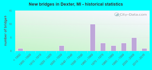
- New bridges - historical statistics
- 1Before 1900
- 21930-1939
- 101960-1969
- 31970-1979
- 21980-1989
- 31990-1999
- 52000-2009
- 12010-2019
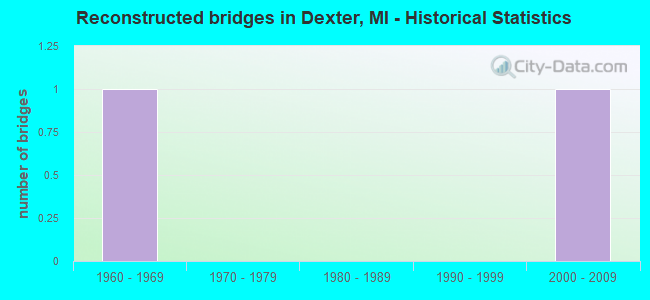
- Reconstructed bridges - Historical Statistics
- 11960-1969
- 01970-1979
- 01980-1989
- 01990-1999
- 12000-2009
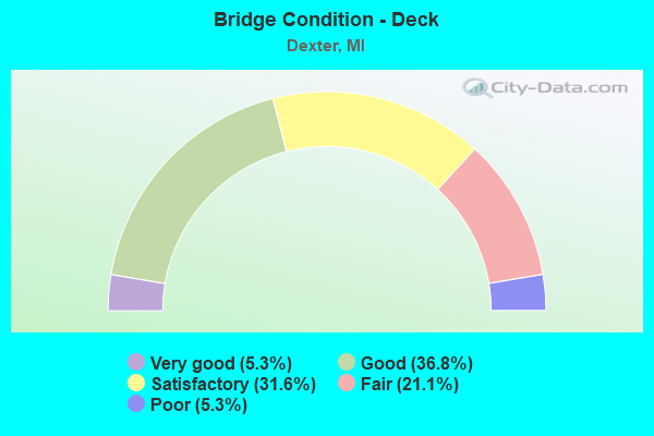
- Bridge Condition - Deck
- 5.3%Very good
- 36.8%Good
- 31.6%Satisfactory
- 21.1%Fair
- 5.3%Poor
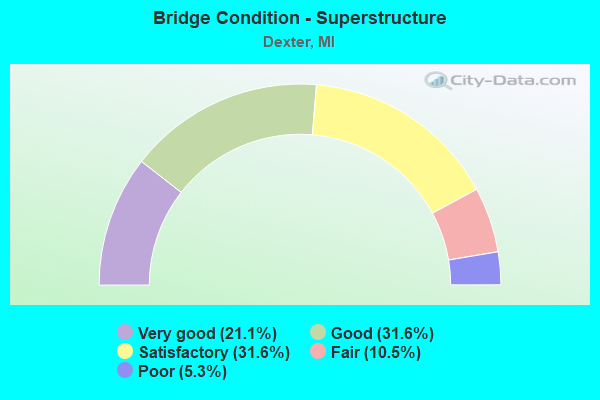
- Bridge Condition - Superstructure
- 21.1%Very good
- 31.6%Good
- 31.6%Satisfactory
- 10.5%Fair
- 5.3%Poor
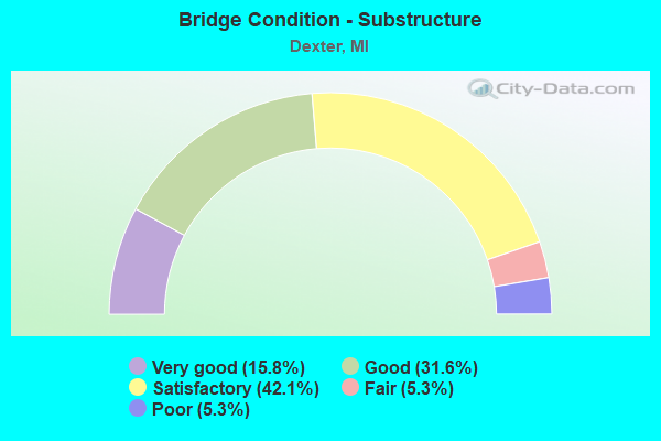
- Bridge Condition - Substructure
- 15.8%Very good
- 31.6%Good
- 42.1%Satisfactory
- 5.3%Fair
- 5.3%Poor
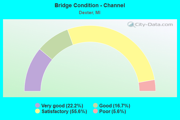
- Bridge Condition - Channel
- 22.2%Very good
- 16.7%Good
- 55.6%Satisfactory
- 5.6%Poor
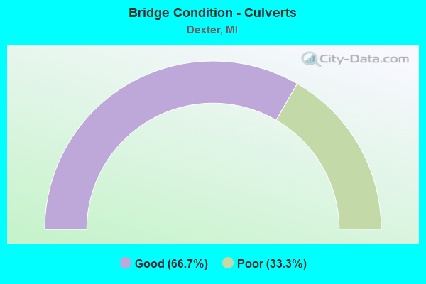
- Bridge Condition - Culverts
- 66.7%Good
- 33.3%Poor
Find on map >> Show street view
Structure Number: 10927, Location: 5.1 MI W OF M-14 (Lat: 42.297467, Lng: -83.901431), Route carried "on" structure: Interstate 94, Year Built: 1961, Status: Open, Structure Length: 1.83m (6.00ft), Average Daily Traffic: 33,463 (year 2020), Truck Traffic: 13%, Average Future Daily Traffic: 36,238 (year 2037), Design Load: HS 20, Features Intersected: MILL CREEK
Minimum Vertical Clearance: 30.48m (100.00ft), Kilometerpoint: 19.265, Lanes on structure: 2, Base Highway Network: Yes (Inventory Route: 142, Subroute: 9), Owner: State Highway Agency, Approaching Roadway Width: 12.8m (42.0ft), Skew: 1 degrees, Material/Design: Prestressed concrete, Design/Construction: Stringer/Multi-beam, Number Of Spans In Main Unit: 1, Length of Maximum Span: 17.1m (56.1ft), Curb-To-Curb Width: 12.8m (42.0ft), Out-to-Out Width: 14.4m (47.2ft)
Condition: Deck: Satisfactory, Superstructure: Good, Substructure: Satisfactory, Channel: Satisfactory, Operating Rating: 71.3 metric tons, Method Used To Determine Operating Rating: Load Factor (LF), Inventory Rating: 42.7 metric tons, Method Used To Determine Inventory Rating: Load Factor (LF), Structural Evaluation: Equal to present minimum criteria, Deck Geometry: Equal to present desirable criteria, Waterway Adequacy: Equal to present desirable criteria, Approach Roadway Alignment: Equal to present desirable criteria, Designated Inspection Frequency: Every 24 months, Inspection Date: July 2020, Deck Structure Type: Concrete Cast-file-Place, Wearing Surface/Protective System: Wearing Surface: Epoxy Overlay
Find on map >> Show street view
Structure Number: 10928, Location: 5.1 MI W OF M-14 (Lat: 42.297733, Lng: -83.901364), Route carried "on" structure: Interstate 94, Year Built: 1961, Status: Open, Structure Length: 1.83m (6.00ft), Average Daily Traffic: 33,463 (year 2020), Truck Traffic: 13%, Average Future Daily Traffic: 36,238 (year 2037), Design Load: HS 20, Features Intersected: MILL CREEK
Minimum Vertical Clearance: 30.48m (100.00ft), Kilometerpoint: 19.166, Lanes on structure: 2, Base Highway Network: Yes (Inventory Route: 142, Subroute: 10), Owner: State Highway Agency, Approaching Roadway Width: 12.8m (42.0ft), Skew: 1 degrees, Material/Design: Prestressed concrete, Design/Construction: Stringer/Multi-beam, Number Of Spans In Main Unit: 1, Length of Maximum Span: 17.1m (56.1ft), Curb-To-Curb Width: 12.8m (42.0ft), Out-to-Out Width: 14.4m (47.2ft)
Condition: Deck: Satisfactory, Superstructure: Good, Substructure: Good, Channel: Satisfactory, Operating Rating: 71.3 metric tons, Method Used To Determine Operating Rating: Load Factor (LF), Inventory Rating: 42.7 metric tons, Method Used To Determine Inventory Rating: Load Factor (LF), Structural Evaluation: Better than present minimum criteria, Deck Geometry: Equal to present desirable criteria, Waterway Adequacy: Equal to present desirable criteria, Approach Roadway Alignment: Equal to present desirable criteria, Designated Inspection Frequency: Every 24 months, Inspection Date: July 2020, Deck Structure Type: Concrete Cast-file-Place, Wearing Surface/Protective System: Wearing Surface: Epoxy Overlay
Find on map >> Show street view
Structure Number: 10942, Location: 4.5 MI E OF M-52 (Lat: 42.298128, Lng: -83.937711), Route carried "on" structure: Interstate 94, Year Built: 1961, Status: Open, Structure Length: 3.41m (11.19ft), Average Daily Traffic: 33,463 (year 2020), Truck Traffic: 13%, Average Future Daily Traffic: 36,238 (year 2037), Design Load: HS 20, Features Intersected: DANCER RD
Minimum Vertical Clearance: 30.48m (100.00ft), Kilometerpoint: 16.258, Lanes on structure: 2, Lanes under structure: 2, Base Highway Network: Yes (Inventory Route: 142, Subroute: 9), Owner: State Highway Agency, Approaching Roadway Width: 12.8m (42.0ft), Skew: 1 degrees, Material/Design: Prestressed concrete, Design/Construction: Stringer/Multi-beam, Number Of Spans In Main Unit: 3, Length of Maximum Span: 12.5m (41.0ft), Curb-To-Curb Width: 12.8m (42.0ft), Out-to-Out Width: 14.4m (47.2ft)
Condition: Deck: Fair, Superstructure: Fair, Substructure: Satisfactory, Operating Rating: 49.2 metric tons, Method Used To Determine Operating Rating: Load Factor (LF) rating reported by rating factor (RF) method using MS18 loading, Inventory Rating: 29.5 metric tons, Method Used To Determine Inventory Rating: Load Factor (LF) rating reported by rating factor (RF) method using MS18 loading, Structural Evaluation: Somewhat better than minimum adequacy, Deck Geometry: Equal to present desirable criteria, Underclear: Somewhat better than minimum adequacy, Approach Roadway Alignment: Better than present minimum criteria, Designated Inspection Frequency: Every 12 months, Other Special Inspection Frequency: Every 12 months, Inspection Date: June 2021, Other Special Inspection Date: June 2021, Deck Structure Type: Concrete Cast-file-Place, Wearing Surface/Protective System: Wearing Surface: Epoxy Overlay
Find on map >> Show street view
Structure Number: 10943, Location: 4.5 MI E OF M-52 (Lat: 42.298383, Lng: -83.937717), Route carried "on" structure: Interstate 94, Year Built: 1961, Status: Open, Structure Length: 3.41m (11.19ft), Average Daily Traffic: 33,463 (year 2020), Truck Traffic: 13%, Average Future Daily Traffic: 36,238 (year 2037), Design Load: HS 20, Features Intersected: DANCER RD
Minimum Vertical Clearance: 30.48m (100.00ft), Kilometerpoint: 16.154, Lanes on structure: 2, Lanes under structure: 2, Base Highway Network: Yes (Inventory Route: 142, Subroute: 10), Owner: State Highway Agency, Approaching Roadway Width: 12.8m (42.0ft), Skew: 1 degrees, Material/Design: Prestressed concrete, Design/Construction: Stringer/Multi-beam, Number Of Spans In Main Unit: 3, Length of Maximum Span: 12.5m (41.0ft), Curb-To-Curb Width: 12.8m (42.0ft), Out-to-Out Width: 14.4m (47.2ft)
Condition: Deck: Satisfactory, Superstructure: Fair, Substructure: Satisfactory, Operating Rating: 54.8 metric tons, Method Used To Determine Operating Rating: Load Factor (LF) rating reported by rating factor (RF) method using MS18 loading, Inventory Rating: 32.7 metric tons, Method Used To Determine Inventory Rating: Load Factor (LF) rating reported by rating factor (RF) method using MS18 loading, Structural Evaluation: Somewhat better than minimum adequacy, Deck Geometry: Equal to present desirable criteria, Underclear: Somewhat better than minimum adequacy, Approach Roadway Alignment: Better than present minimum criteria, Designated Inspection Frequency: Every 12 months, Inspection Date: June 2021, Deck Structure Type: Concrete Cast-file-Place, Wearing Surface/Protective System: Wearing Surface: Epoxy Overlay
Find on map >> Show street view
Structure Number: 10944, Location: 4.9 MI W OF M-14 (Lat: 42.297575, Lng: -83.898453), Route carried "on" structure: County highway , Year Built: 1961, Status: Open, Structure Length: 7.62m (25.00ft), Average Daily Traffic: 2,534 (year 1996), Truck Traffic: 3%, Average Future Daily Traffic: 2,914 (year 2016), Design Load: H 20, Features Intersected: I-94, Facility Carried by Structure: PARKER RD
Minimum Vertical Clearance: 30.48m (100.00ft), Kilometerpoint: 10.406, Lanes on structure: 2, Lanes under structure: 4, Owner: State Highway Agency, Approaching Roadway Width: 9.1m (29.9ft), Material/Design: Prestressed concrete, Design/Construction: Stringer/Multi-beam, Number Of Spans In Main Unit: 4, Length of Maximum Span: 21.6m (70.9ft), Curb-To-Curb Width: 8.9m (29.2ft), Out-to-Out Width: 10.1m (33.1ft)
Condition: Deck: Fair, Superstructure: Satisfactory, Substructure: Satisfactory, Operating Rating: 53.8 metric tons, Method Used To Determine Operating Rating: Load Factor (LF) rating reported by rating factor (RF) method using MS18 loading, Inventory Rating: 32.1 metric tons, Method Used To Determine Inventory Rating: Load Factor (LF) rating reported by rating factor (RF) method using MS18 loading, Structural Evaluation: Equal to present minimum criteria, Deck Geometry: Meets minimum limits, Underclear: Meets minimum limits, Approach Roadway Alignment: Equal to present desirable criteria, Designated Inspection Frequency: Every 24 months, Inspection Date: July 2020, Deck Structure Type: Concrete Cast-file-Place, Wearing Surface/Protective System: Wearing Surface: Latex Concrete
Find on map >> Show street view
Structure Number: 10945, Location: 3.9 MI W OF M-14 (Lat: 42.298361, Lng: -83.878047), Route carried "on" structure: County highway 2006, Year Built: 2006, Status: Open, Structure Length: 8.80m (28.87ft), Average Daily Traffic: 12,582 (year 2001), Truck Traffic: 3%, Average Future Daily Traffic: 19,700 (year 2020), Design Load: HS 20, Features Intersected: I-94, Facility Carried by Structure: BAKER RD
Minimum Vertical Clearance: 30.48m (100.00ft), Kilometerpoint: 0.521, Lanes on structure: 5, Lanes under structure: 8, Owner: State Highway Agency, Approaching Roadway Width: 24.4m (80.1ft), Material/Design: Prestressed concrete, Design/Construction: Box Beam or Girders - Multiple, Number Of Spans In Main Unit: 4, Length of Maximum Span: 29.0m (95.1ft), Curb-To-Curb Width: 24.4m (80.1ft), Out-to-Out Width: 25.1m (82.3ft)
Condition: Deck: Good, Superstructure: Satisfactory, Substructure: Satisfactory, Operating Rating: 70.6 metric tons, Method Used To Determine Operating Rating: Load Factor (LF) rating reported by rating factor (RF) method using MS18 loading, Inventory Rating: 42.4 metric tons, Method Used To Determine Inventory Rating: Load Factor (LF) rating reported by rating factor (RF) method using MS18 loading, Structural Evaluation: Equal to present minimum criteria, Deck Geometry: Superior to present desirable criteria, Underclear: Equal to present minimum criteria, Approach Roadway Alignment: Equal to present minimum criteria, Designated Inspection Frequency: Every 24 months, Inspection Date: July 2020, Deck Structure Type: Concrete Cast-file-Place, Wearing Surface/Protective System: Wearing Surface: Integral Concrete, Deck Protection: Epoxy Coated Reinforcing
Find on map >> Show street view
Structure Number: 10979, Location: LIMA TWP SECTION 24 (Lat: 42.290450, Lng: -83.907122), Route carried "on" structure: County highway 8160, Year Built: 1936, Year Reconstructed: 2014, Status: Open, Structure Length: 1.83m (6.00ft), Average Daily Traffic: 5,770 (year 2012), Truck Traffic: 14%, Average Future Daily Traffic: 6,407 (year 2033), Design Load: HS 20, Features Intersected: MILL CREEK, Facility Carried by Structure: JACKSON AVE
Minimum Vertical Clearance: 30.48m (100.00ft), Kilometerpoint: 20.314, Lanes on structure: 2, Owner: County Highway Agency, Approaching Roadway Width: 13.4m (44.0ft), Skew: 1 degrees, Material/Design: Steel, Design/Construction: Stringer/Multi-beam, Number Of Spans In Main Unit: 1, Length of Maximum Span: 17.8m (58.4ft), Curb-To-Curb Width: 12.2m (40.0ft), Out-to-Out Width: 12.9m (42.3ft)
Condition: Deck: Very good, Superstructure: Good, Substructure: Satisfactory, Channel: Satisfactory, Operating Rating: 75.5 metric tons, Method Used To Determine Operating Rating: Load and Resistance Factor Rating (LRFR) rating reported by rating factor(RF) method using HL-93 loadings, Inventory Rating: 58.3 metric tons, Method Used To Determine Inventory Rating: Load and Resistance Factor Rating (LRFR) rating reported by rating factor(RF) method using HL-93 loadings, Structural Evaluation: Equal to present minimum criteria, Deck Geometry: Somewhat better than minimum adequacy, Waterway Adequacy: Equal to present desirable criteria, Approach Roadway Alignment: Equal to present desirable criteria, Designated Inspection Frequency: Every 24 months, Inspection Date: June 2021, Deck Structure Type: Concrete Cast-file-Place, Wearing Surface/Protective System: Wearing Surface: Monolithic Concrete, Deck Protection: Epoxy Coated Reinforcing
Find on map >> Show street view
Structure Number: 1098, Location: SECTION 21 SCIO TOWNSHIP (Lat: 42.289336, Lng: -83.844606), Route carried "on" structure: County highway 2006, Year Built: 1999, Status: Open, Structure Length: 1.12m (3.67ft), Average Daily Traffic: 10,088 (year 2006), Truck Traffic: 15%, Average Future Daily Traffic: 18,219 (year 2026), Features Intersected: HONEY CREEK, Facility Carried by Structure: JACKSON RD (WB)
Minimum Vertical Clearance: 30.48m (100.00ft), Kilometerpoint: 25.575, Lanes on structure: 2, Owner: County Highway Agency, Approaching Roadway Width: 15.9m (52.2ft), Skew: 4 degrees, Material/Design: Concrete, Design/Construction: Culvert, Number Of Spans In Main Unit: 1, Length of Maximum Span: 10.6m (34.8ft)
Condition: Channel: Satisfactory, Culverts: Good, Operating Rating: 54.6 metric tons, Method Used To Determine Operating Rating: Field evaluation and documented engineering judgment, Inventory Rating: 32.7 metric tons, Method Used To Determine Inventory Rating: Field evaluation and documented engineering judgment, Structural Evaluation: Better than present minimum criteria, Waterway Adequacy: Equal to present desirable criteria, Approach Roadway Alignment: Equal to present desirable criteria, Designated Inspection Frequency: Every 24 months, Inspection Date: June 2021
Find on map >> Show street view
Structure Number: 10988, Location: DEXTER TWP SECTION 13 (Lat: 42.387075, Lng: -83.910858), Route carried "on" structure: County highway 8184, Year Built: 1995, Status: Open, Structure Length: 6.10m (20.01ft), Average Daily Traffic: 9,058 (year 2009), Truck Traffic: 8%, Average Future Daily Traffic: 17,515 (year 2029), Design Load: HS 20, Features Intersected: HURON RIVER, Facility Carried by Structure: NORTH TERRITORIAL
Minimum Vertical Clearance: 30.48m (100.00ft), Kilometerpoint: 14.642, Lanes on structure: 2, Owner: County Highway Agency, Approaching Roadway Width: 10.1m (33.1ft), Skew: 1 degrees, Material/Design: Prestressed concrete, Design/Construction: Box Beam or Girders - Multiple, Number Of Spans In Main Unit: 3, Length of Maximum Span: 20.3m (66.6ft), Curb or Sidewalk Widths: Left: 0.0m, Right: 3.7m (12.1ft), Curb-To-Curb Width: 12.3m (40.4ft), Out-to-Out Width: 17.2m (56.4ft)
Condition: Deck: Satisfactory, Superstructure: Good, Substructure: Satisfactory, Channel: Satisfactory, Operating Rating: 85.7 metric tons, Method Used To Determine Operating Rating: Load Factor (LF), Inventory Rating: 51.4 metric tons, Method Used To Determine Inventory Rating: Load Factor (LF), Structural Evaluation: Equal to present minimum criteria, Deck Geometry: Somewhat better than minimum adequacy, Waterway Adequacy: Equal to present desirable criteria, Approach Roadway Alignment: Equal to present desirable criteria, Designated Inspection Frequency: Every 24 months, Inspection Date: July 2021, Deck Structure Type: Concrete Cast-file-Place, Wearing Surface/Protective System: Wearing Surface: Epoxy Overlay, Deck Protection: Epoxy Coated Reinforcing
Find on map >> Show street view
Structure Number: 10992, Location: SCIO TWP SECTION 6 (Lat: 42.338964, Lng: -83.890636), Route carried "on" structure: County highway 8137, Year Built: 2008, Status: Open, Structure Length: 3.08m (10.10ft), Average Daily Traffic: 18,086 (year 2004), Truck Traffic: 7%, Average Future Daily Traffic: 30,023 (year 2026), Design Load: HS 20+Mod, Features Intersected: MILL CREEK, Facility Carried by Structure: DEXTER MAIN STREET
Minimum Vertical Clearance: 30.48m (100.00ft), Kilometerpoint: 0.941, Lanes on structure: 3, Owner: County Highway Agency, Approaching Roadway Width: 13.7m (44.9ft), Material/Design: Prestressed concrete, Design/Construction: Stringer/Multi-beam, Number Of Spans In Main Unit: 1, Length of Maximum Span: 29.3m (96.1ft), Curb or Sidewalk Widths: Left: 1.8m (5.9ft), Right: 1.8m (5.9ft), Curb-To-Curb Width: 14.6m (47.9ft), Out-to-Out Width: 18.9m (62.0ft)
Condition: Deck: Good, Superstructure: Very good, Substructure: Very good, Channel: Very good, Inventory Rating: 67.9 metric tons, Method Used To Determine Inventory Rating: Load Factor (LF), Structural Evaluation: Equal to present desirable criteria, Deck Geometry: Somewhat better than minimum adequacy, Waterway Adequacy: Equal to present desirable criteria, Approach Roadway Alignment: Equal to present desirable criteria, Designated Inspection Frequency: Every 24 months, Inspection Date: May 2021, Deck Structure Type: Concrete Cast-file-Place, Wearing Surface/Protective System: Wearing Surface: Monolithic Concrete, Deck Protection: Epoxy Coated Reinforcing
Find on map >> Show street view
Structure Number: 10996, Location: WEBSTER TWP SEC 31 (Lat: 42.341344, Lng: -83.879622), Route carried "on" structure: County highway 8143, Year Built: 1976, Status: Open, Structure Length: 5.58m (18.31ft), Average Daily Traffic: 10,929 (year 2020), Truck Traffic: 9%, Average Future Daily Traffic: 16,240 (year 2040), Design Load: HS 20+Mod, Features Intersected: HURON RIVER, Facility Carried by Structure: MAST ROAD
Minimum Vertical Clearance: 30.48m (100.00ft), Kilometerpoint: 0.867, Lanes on structure: 4, Owner: County Highway Agency, Approaching Roadway Width: 14.0m (45.9ft), Material/Design: Prestressed concrete, Design/Construction: Stringer/Multi-beam, Number Of Spans In Main Unit: 3, Length of Maximum Span: 18.6m (61.0ft), Curb or Sidewalk Widths: Left: 1.5m (4.9ft), Right: 1.5m (4.9ft), Curb-To-Curb Width: 14.3m (46.9ft), Out-to-Out Width: 18.1m (59.4ft)
Condition: Deck: Good, Superstructure: Very good, Substructure: Satisfactory, Channel: Good, Operating Rating: 74.8 metric tons, Method Used To Determine Operating Rating: Load Factor (LF), Inventory Rating: 44.8 metric tons, Method Used To Determine Inventory Rating: Load Factor (LF), Structural Evaluation: Equal to present minimum criteria, Deck Geometry: High priority of replacement, Waterway Adequacy: Equal to present desirable criteria, Approach Roadway Alignment: Equal to present minimum criteria, Length Of Structure Improvement: 6.71m (22.01ft), Designated Inspection Frequency: Every 24 months, Inspection Date: April 2020, Bridge Improvement Cost: $600,000, Roadway Improvement Cost: $80,000, Total Project Cost: $700,000, Deck Structure Type: Concrete Cast-file-Place, Wearing Surface/Protective System: Wearing Surface: Epoxy Overlay
Find on map >> Show street view
Structure Number: 10998, Location: SC10 TWP SEC 9 & 10 (Lat: 42.324425, Lng: -83.839417), Route carried "on" structure: County highway 8151, Year Built: 1961, Status: Open, Structure Length: 3.35m (10.99ft), Average Daily Traffic: 7,241 (year 2010), Truck Traffic: 8%, Average Future Daily Traffic: 11,865 (year 2031), Design Load: HS 20+Mod, Features Intersected: HURON RIVER, Facility Carried by Structure: ZEEB ROAD
Minimum Vertical Clearance: 30.48m (100.00ft), Kilometerpoint: 14.158, Lanes on structure: 2, Owner: County Highway Agency, Approaching Roadway Width: 10.1m (33.1ft), Skew: 3 degrees, Material/Design: Concrete continuous, Design/Construction: Slab, Number Of Spans In Main Unit: 3, Length of Maximum Span: 13.1m (43.0ft), Curb-To-Curb Width: 9.6m (31.5ft), Out-to-Out Width: 10.3m (33.8ft)
Condition: Deck: Satisfactory, Superstructure: Satisfactory, Substructure: Good, Channel: Satisfactory, Operating Rating: 50.9 metric tons, Method Used To Determine Operating Rating: Load Factor (LF) rating reported by rating factor (RF) method using MS18 loading, Inventory Rating: 30.5 metric tons, Method Used To Determine Inventory Rating: Load Factor (LF) rating reported by rating factor (RF) method using MS18 loading, Structural Evaluation: Equal to present minimum criteria, Deck Geometry: High priority of corrective action, Waterway Adequacy: Equal to present desirable criteria, Approach Roadway Alignment: High priority of corrective action, Length Of Structure Improvement: 3.96m (12.99ft), Designated Inspection Frequency: Every 24 months, Inspection Date: July 2021, Bridge Improvement Cost: $390,000, Roadway Improvement Cost: $140,000, Total Project Cost: $625,000, Deck Structure Type: Concrete Cast-file-Place, Wearing Surface/Protective System: Wearing Surface: Epoxy Overlay
Find on map >> Show street view
Structure Number: 11015, Location: LIMA TWP SEC 23 & 26 (Lat: 42.281856, Lng: -83.922683), Route carried "on" structure: County highway , Year Built: 1974, Status: Posted for load, Structure Length: 1.03m (3.38ft), Average Daily Traffic: 129 (year 2005), Truck Traffic: 5%, Average Future Daily Traffic: 233 (year 2025), Design Load: HS 20, Features Intersected: MILL CREEK, Facility Carried by Structure: JERUSALEM ROAD
Minimum Vertical Clearance: 30.48m (100.00ft), Kilometerpoint: 1.172, Lanes on structure: 2, Owner: County Highway Agency, Approaching Roadway Width: 6.1m (20.0ft), Material/Design: Prestressed concrete, Design/Construction: Box Beam or Girders - Multiple, Number Of Spans In Main Unit: 1, Length of Maximum Span: 10.0m (32.8ft), Curb-To-Curb Width: 4.9m (16.1ft), Out-to-Out Width: 5.4m (17.7ft)
Condition: Deck: Poor, Superstructure: Poor, Substructure: Poor, Channel: Poor, Operating Rating: 37.1 metric tons, Method Used To Determine Operating Rating: Load Factor (LF), Inventory Rating: 22.2 metric tons, Method Used To Determine Inventory Rating: Load Factor (LF), Structural Evaluation: Meets minimum limits, Deck Geometry: High priority of replacement, Waterway Adequacy: Equal to present minimum criteria, Approach Roadway Alignment: High priority of corrective action, Bridge Posting: Required (Relationship of Operating Rating to Maximum Legal Load: 20.0 - 29.9% below), Length Of Structure Improvement: 1.25m (4.10ft), Designated Inspection Frequency: Every 12 months, Inspection Date: May 2021, Bridge Improvement Cost: $80,000, Roadway Improvement Cost: $20,000, Total Project Cost: $140,000, Deck Structure Type: Concrete Precast Panels, Wearing Surface/Protective System: Wearing Surface: Gravel
Find on map >> Show street view
Structure Number: 11016, Location: LIMA TWP SEC 24 & 25 (Lat: 42.282375, Lng: -83.906581), Route carried "on" structure: County highway , Year Built: 1933, Year Reconstructed: 1974, Status: Open, Structure Length: 0.73m (2.40ft), Average Daily Traffic: 89 (year 2016), Truck Traffic: 5%, Average Future Daily Traffic: 98 (year 2036), Design Load: HS 20, Features Intersected: MILL CREEK, Facility Carried by Structure: JERUSALEM RD
Minimum Vertical Clearance: 30.48m (100.00ft), Kilometerpoint: 2.501, Lanes on structure: 2, Owner: County Highway Agency, Approaching Roadway Width: 6.4m (21.0ft), Material/Design: Prestressed concrete, Design/Construction: Box Beam or Girders - Multiple, Number Of Spans In Main Unit: 1, Length of Maximum Span: 7.3m (24.0ft), Curb-To-Curb Width: 5.0m (16.4ft), Out-to-Out Width: 5.5m (18.0ft)
Condition: Deck: Fair, Superstructure: Satisfactory, Substructure: Fair, Channel: Good, Operating Rating: 95.6 metric tons, Method Used To Determine Operating Rating: Load Factor (LF), Inventory Rating: 57.3 metric tons, Method Used To Determine Inventory Rating: Load Factor (LF), Structural Evaluation: Somewhat better than minimum adequacy, Deck Geometry: High priority of corrective action, Waterway Adequacy: Better than present minimum criteria, Approach Roadway Alignment: Equal to present minimum criteria, Length Of Structure Improvement: 1.22m (4.00ft), Designated Inspection Frequency: Every 24 months, Inspection Date: April 2021, Bridge Improvement Cost: $100,000, Roadway Improvement Cost: $30,000, Total Project Cost: $145,000, Deck Structure Type: Concrete Precast Panels, Wearing Surface/Protective System: Wearing Surface: Bituminous, Membrane: Preformed Fabric
Find on map >> Show street view
Structure Number: 11021, Location: LIMA TWP SEC 22 & 23 (Lat: 42.287614, Lng: -83.937197), Route carried "on" structure: County highway , Year Built: 1980, Status: Open, Structure Length: 1.34m (4.40ft), Average Daily Traffic: 167 (year 2003), Truck Traffic: 10%, Average Future Daily Traffic: 210 (year 2023), Design Load: HS 20+Mod, Features Intersected: MILL CREEK, Facility Carried by Structure: DANCER ROAD
Minimum Vertical Clearance: 30+ m (98+ ft), Kilometerpoint: 2.285, Lanes on structure: 2, Owner: County Highway Agency, Approaching Roadway Width: 7.9m (25.9ft), Material/Design: Wood or Timber, Design/Construction: Slab, Number Of Spans In Main Unit: 2, Length of Maximum Span: 6.4m (21.0ft), Curb-To-Curb Width: 9.1m (29.9ft), Out-to-Out Width: 10.0m (32.8ft)
Condition: Deck: Fair, Superstructure: Satisfactory, Substructure: Good, Channel: Satisfactory, Operating Rating: 36.0 metric tons, Method Used To Determine Operating Rating: Allowable Stress (AS), Inventory Rating: 26.0 metric tons, Method Used To Determine Inventory Rating: Allowable Stress (AS), Structural Evaluation: Equal to present minimum criteria, Deck Geometry: Equal to present minimum criteria, Waterway Adequacy: Equal to present desirable criteria, Approach Roadway Alignment: Equal to present desirable criteria, Length Of Structure Improvement: 1.83m (6.00ft), Designated Inspection Frequency: Every 24 months, Inspection Date: June 2021, Bridge Improvement Cost: $180,000, Roadway Improvement Cost: $80,000, Total Project Cost: $260,000, Deck Structure Type: Wood or Timber, Wearing Surface/Protective System: Wearing Surface: Gravel
Find on map >> Show street view
Structure Number: 11023, Location: LIMA TWP SEC 23 & 24 (Lat: 42.285228, Lng: -83.917397), Route carried "on" structure: County highway , Year Built: 1984, Status: Open, Structure Length: 2.13m (6.99ft), Average Daily Traffic: 87 (year 2003), Truck Traffic: 7%, Average Future Daily Traffic: 110 (year 2023), Design Load: HS 20+Mod, Features Intersected: MILL CREEK, Facility Carried by Structure: STEINBACH ROAD
Minimum Vertical Clearance: 30.48m (100.00ft), Kilometerpoint: 3.616, Lanes on structure: 2, Owner: County Highway Agency, Approaching Roadway Width: 9.1m (29.9ft), Skew: 2 degrees, Material/Design: Wood or Timber, Design/Construction: Slab, Number Of Spans In Main Unit: 3, Length of Maximum Span: 7.9m (25.9ft), Curb-To-Curb Width: 9.1m (29.9ft), Out-to-Out Width: 9.8m (32.2ft)
Condition: Deck: Good, Superstructure: Good, Substructure: Good, Channel: Satisfactory, Operating Rating: 39.4 metric tons, Method Used To Determine Operating Rating: Allowable Stress (AS), Inventory Rating: 28.3 metric tons, Method Used To Determine Inventory Rating: Allowable Stress (AS), Structural Evaluation: Better than present minimum criteria, Deck Geometry: Better than present minimum criteria, Waterway Adequacy: Equal to present desirable criteria, Approach Roadway Alignment: Equal to present desirable criteria, Length Of Structure Improvement: 2.90m (9.51ft), Designated Inspection Frequency: Every 24 months, Inspection Date: June 2021, Bridge Improvement Cost: $185,000, Roadway Improvement Cost: $60,000, Total Project Cost: $260,000, Deck Structure Type: Wood or Timber, Wearing Surface/Protective System: Wearing Surface: Bituminous
Find on map >> Show street view
Structure Number: 11026, Location: SCIO TWP SEC 18 (Lat: 42.304781, Lng: -83.889261), Route carried "on" structure: County highway , Year Built: 1976, Status: Open, Structure Length: 2.37m (7.78ft), Average Daily Traffic: 807 (year 2006), Average Future Daily Traffic: 1,457 (year 2026), Design Load: HS 20, Features Intersected: MILL CREEK, Facility Carried by Structure: MARSHALL RD
Minimum Vertical Clearance: 30.48m (100.00ft), Kilometerpoint: 0.779, Lanes on structure: 2, Owner: County Highway Agency, Approaching Roadway Width: 10.1m (33.1ft), Material/Design: Prestressed concrete, Design/Construction: Box Beam or Girders - Multiple, Number Of Spans In Main Unit: 1, Length of Maximum Span: 23.7m (77.8ft), Curb-To-Curb Width: 10.1m (33.1ft), Out-to-Out Width: 10.3m (33.8ft)
Condition: Deck: Satisfactory, Superstructure: Satisfactory, Substructure: Good, Channel: Good, Operating Rating: 65.9 metric tons, Method Used To Determine Operating Rating: Load Factor (LF), Inventory Rating: 39.5 metric tons, Method Used To Determine Inventory Rating: Load Factor (LF), Structural Evaluation: Equal to present minimum criteria, Deck Geometry: Equal to present minimum criteria, Waterway Adequacy: Equal to present desirable criteria, Approach Roadway Alignment: Equal to present desirable criteria, Length Of Structure Improvement: 4.27m (14.01ft), Designated Inspection Frequency: Every 24 months, Inspection Date: June 2021, Bridge Improvement Cost: $325,000, Roadway Improvement Cost: $33,000, Total Project Cost: $384,000, Deck Structure Type: Concrete Precast Panels, Wearing Surface/Protective System: Wearing Surface: Latex Concrete
Find on map >> Show street view
Structure Number: 11027, Location: SC10 TWP SEC 7 (Lat: 42.325156, Lng: -83.892344), Route carried "on" structure: County highway , Year Built: 2017, Status: Open, Structure Length: 2.64m (8.66ft), Average Daily Traffic: 3,403 (year 2017), Truck Traffic: 5%, Average Future Daily Traffic: 3,686 (year 2037), Design Load: Greater than HL93, Features Intersected: MILL CREEK, Facility Carried by Structure: SHIELD RD
Minimum Vertical Clearance: 30.48m (100.00ft), Kilometerpoint: 0.599, Lanes on structure: 2, Owner: County Highway Agency, Approaching Roadway Width: 11.6m (38.1ft), Skew: 2 degrees, Material/Design: Prestressed concrete, Design/Construction: Stringer/Multi-beam, Number Of Spans In Main Unit: 1, Length of Maximum Span: 25.6m (84.0ft), Curb-To-Curb Width: 11.6m (38.1ft), Out-to-Out Width: 12.4m (40.7ft)
Condition: Deck: Good, Superstructure: Very good, Substructure: Very good, Channel: Very good, Operating Rating: 71.9 metric tons, Method Used To Determine Operating Rating: Load and Resistance Factor Rating (LRFR) rating reported by rating factor(RF) method using HL-93 loadings, Inventory Rating: 55.4 metric tons, Method Used To Determine Inventory Rating: Load and Resistance Factor Rating (LRFR) rating reported by rating factor(RF) method using HL-93 loadings, Structural Evaluation: Equal to present desirable criteria, Deck Geometry: Somewhat better than minimum adequacy, Waterway Adequacy: Equal to present desirable criteria, Approach Roadway Alignment: Equal to present desirable criteria, Length Of Structure Improvement: 3.08m (10.10ft), Designated Inspection Frequency: Every 24 months, Inspection Date: November 2021, Bridge Improvement Cost: $230,000, Roadway Improvement Cost: $65,000, Total Project Cost: $320,000, Deck Structure Type: Concrete Cast-file-Place, Wearing Surface/Protective System: Wearing Surface: Monolithic Concrete, Deck Protection: Epoxy Coated Reinforcing
Find on map >> Show street view
Structure Number: 11028, Location: SCIO TWP SEC 18 (Lat: 42.299950, Lng: -83.898500), Route carried "on" structure: County highway , Year Built: 2007, Status: Open, Structure Length: 2.29m (7.51ft), Average Daily Traffic: 2,867 (year 2004), Truck Traffic: 9%, Average Future Daily Traffic: 5,178 (year 2024), Design Load: HS 20+Mod, Features Intersected: MILL CREEK, Facility Carried by Structure: PARKER RD
Minimum Vertical Clearance: 30.48m (100.00ft), Kilometerpoint: 10.688, Lanes on structure: 2, Owner: County Highway Agency, Approaching Roadway Width: 7.9m (25.9ft), Material/Design: Prestressed concrete, Design/Construction: Stringer/Multi-beam, Number Of Spans In Main Unit: 1, Length of Maximum Span: 21.6m (70.9ft), Curb-To-Curb Width: 12.2m (40.0ft), Out-to-Out Width: 13.2m (43.3ft)
Condition: Deck: Good, Superstructure: Very good, Substructure: Very good, Channel: Very good, Operating Rating: 71.1 metric tons, Method Used To Determine Operating Rating: Load Factor (LF), Inventory Rating: 42.6 metric tons, Method Used To Determine Inventory Rating: Load Factor (LF), Structural Evaluation: Equal to present desirable criteria, Deck Geometry: Equal to present minimum criteria, Waterway Adequacy: Equal to present desirable criteria, Approach Roadway Alignment: Equal to present desirable criteria, Designated Inspection Frequency: Every 24 months, Inspection Date: May 2021, Deck Structure Type: Concrete Cast-file-Place, Wearing Surface/Protective System: Wearing Surface: Monolithic Concrete, Deck Protection: Epoxy Coated Reinforcing
Find on map >> Show street view
Structure Number: 1283, Location: SECTION 21 SCIO TOWNSHIP (Lat: 42.289336, Lng: -83.844603), Route carried "on" structure: County highway 2006, Year Built: 1999, Status: Open, Structure Length: 1.04m (3.41ft), Average Daily Traffic: 9,850 (year 2006), Truck Traffic: 15%, Average Future Daily Traffic: 17,789 (year 2026), Design Load: HS 20+Mod, Features Intersected: HONEY CREEK, Facility Carried by Structure: JACKSON RD (EB)
Minimum Vertical Clearance: 30.48m (100.00ft), Kilometerpoint: 25.575, Lanes on structure: 2, Owner: County Highway Agency, Approaching Roadway Width: 7.3m (24.0ft), Skew: 4 degrees, Material/Design: Concrete, Design/Construction: Culvert, Number Of Spans In Main Unit: 1, Length of Maximum Span: 10.1m (33.1ft), Out-to-Out Width: 14.7m (48.2ft)
Condition: Channel: Satisfactory, Culverts: Good, Operating Rating: 54.6 metric tons, Method Used To Determine Operating Rating: Field evaluation and documented engineering judgment, Inventory Rating: 32.7 metric tons, Method Used To Determine Inventory Rating: Field evaluation and documented engineering judgment, Structural Evaluation: Better than present minimum criteria, Waterway Adequacy: Equal to present desirable criteria, Approach Roadway Alignment: Equal to present desirable criteria, Designated Inspection Frequency: Every 24 months, Inspection Date: June 2021
Find on map >> Show street view
Structure Number: 1326, Location: SCIO TWP SEC 20 (Lat: 42.286353, Lng: -83.858042), Route carried "on" structure: County highway , Year Built: 2004, Status: Open, Structure Length: 0.77m (2.53ft), Average Daily Traffic: 726 (year 2006), Truck Traffic: 5%, Average Future Daily Traffic: 1,311 (year 2026), Design Load: HS 20, Features Intersected: HONEY CREEK, Facility Carried by Structure: STAEBLER ROAD
Minimum Vertical Clearance: 30.48m (100.00ft), Kilometerpoint: 0.742, Lanes on structure: 2, Owner: County Highway Agency, Approaching Roadway Width: 9.8m (32.2ft), Skew: 1 degrees, Material/Design: Wood or Timber, Design/Construction: Slab, Number Of Spans In Main Unit: 1, Length of Maximum Span: 7.7m (25.3ft), Curb-To-Curb Width: 9.1m (29.9ft), Out-to-Out Width: 9.8m (32.2ft)
Condition: Deck: Good, Superstructure: Good, Substructure: Good, Channel: Very good, Operating Rating: 51.0 metric tons, Method Used To Determine Operating Rating: Allowable Stress (AS), Inventory Rating: 37.0 metric tons, Method Used To Determine Inventory Rating: Allowable Stress (AS), Structural Evaluation: Better than present minimum criteria, Deck Geometry: Equal to present minimum criteria, Waterway Adequacy: Equal to present desirable criteria, Approach Roadway Alignment: Equal to present desirable criteria, Designated Inspection Frequency: Every 24 months, Inspection Date: June 2021, Deck Structure Type: Wood or Timber, Wearing Surface/Protective System: Wearing Surface: Bituminous
Find on map >> Show street view
Structure Number: 13913, Location: SCIO TWP SEC 30 (Lat: 42.268100, Lng: -83.897056), Route carried "on" structure: County highway 8139, Year Built: 1968, Status: Open, Structure Length: 0.62m (2.03ft), Average Daily Traffic: 300 (year 2014), Average Future Daily Traffic: 345 (year 2034), Design Load: HS 20, Features Intersected: TRIB TO MILL CREEK, Facility Carried by Structure: PARKER ROAD
Minimum Vertical Clearance: 30.48m (100.00ft), Kilometerpoint: 7.134, Lanes on structure: 2, Owner: County Highway Agency, Approaching Roadway Width: 8.5m (27.9ft), Skew: 4 degrees, Material/Design: Steel, Design/Construction: Culvert, Number Of Spans In Main Unit: 1, Length of Maximum Span: 6.2m (20.3ft), Curb-To-Curb Width: 8.5m (27.9ft), Out-to-Out Width: 26.8m (87.9ft)
Condition: Channel: Satisfactory, Culverts: Poor, Operating Rating: 69.7 metric tons, Method Used To Determine Operating Rating: Load Factor (LF) rating reported by rating factor (RF) method using MS18 loading, Inventory Rating: 66.1 metric tons, Method Used To Determine Inventory Rating: Load Factor (LF) rating reported by rating factor (RF) method using MS18 loading, Structural Evaluation: Meets minimum limits, Deck Geometry: Equal to present minimum criteria, Waterway Adequacy: Better than present minimum criteria, Approach Roadway Alignment: Equal to present minimum criteria, Designated Inspection Frequency: Every 12 months, Inspection Date: September 2021, Wearing Surface/Protective System: Wearing Surface: Bituminous
Find on map >> Show street view
Structure Number: 10942, Location: 4.5 MI E OF M-52 (Lat: 42.298128, Lng: -83.937711), Route carried "under" structure: County highway , Year Built: 1961, Structure Length: 0. m, Average Daily Traffic: 490 (year 1997), Truck Traffic: 3%, Features Intersected: DANCER RD, Facility Carried by Structure: I-94 EB
Minimum Vertical Clearance: 4.37m (14.34ft), Kilometerpoint: 3.454, Lanes on structure: 2, Lanes under structure: 2, Material/Design: Prestressed concrete, Design/Construction: Stringer/Multi-beam, Length of Maximum Span: 12.5m (41.0ft)
Find on map >> Show street view
Structure Number: 10943, Location: 4.5 MI E OF M-52 (Lat: 42.298383, Lng: -83.937717), Route carried "under" structure: County highway , Year Built: 1961, Structure Length: 0. m, Average Daily Traffic: 490 (year 1997), Truck Traffic: 3%, Features Intersected: DANCER RD, Facility Carried by Structure: I-94 WB
Minimum Vertical Clearance: 4.44m (14.57ft), Kilometerpoint: 3.483, Lanes on structure: 2, Lanes under structure: 2, Material/Design: Prestressed concrete, Design/Construction: Stringer/Multi-beam, Length of Maximum Span: 12.5m (41.0ft)
Find on map >> Show street view
Structure Number: 10944, Location: 4.9 MI W OF M-14 (Lat: 42.297575, Lng: -83.898453), Route carried "under" structure: Interstate 94, Year Built: 1961, Structure Length: 0. m, Average Daily Traffic: 57,636 (year 2007), Truck Traffic: 23%, Features Intersected: I-94, Facility Carried by Structure: PARKER RD
Minimum Vertical Clearance: 5.87m (19.26ft), Kilometerpoint: 19.511, Lanes on structure: 2, Lanes under structure: 4, Material/Design: Prestressed concrete, Design/Construction: Stringer/Multi-beam, Length of Maximum Span: 21.6m (70.9ft)
Find on map >> Show street view
Structure Number: 10945, Location: 3.9 MI W OF M-14 (Lat: 42.298361, Lng: -83.878047), Route carried "under" structure: Interstate 94, Year Built: 2006, Structure Length: 0. m, Average Daily Traffic: 60,508 (year 2007), Truck Traffic: 23%, Features Intersected: I-94, Facility Carried by Structure: BAKER RD
Minimum Vertical Clearance: 5.26m (17.26ft), Kilometerpoint: 21.196, Lanes on structure: 5, Lanes under structure: 8, Material/Design: Prestressed concrete, Design/Construction: Box Beam or Girders - Multiple, Length of Maximum Span: 29.0m (95.1ft)
Find on map >> Show street view
Structure Number: 10993, Location: SC10 TWP SEC 6 (Lat: 42.339672, Lng: -83.892119), Route carried "under" structure: ServiceCounty highway 7101, Year Built: 1890, Structure Length: 0. m, Average Daily Traffic: 12,120 (year 1989), Truck Traffic: 7%, Features Intersected: DEXTER-PINCKNEY ROAD, Facility Carried by Structure: MDOT RR CORRIDOR
Minimum Vertical Clearance: 3.18m (10.43ft), Kilometerpoint: 0.824, Lanes under structure: 2, Material/Design: Masonry, Design/Construction: Arch - Deck, Length of Maximum Span: 6.7m (22.0ft)