Bridge Statistics for Doctor Phillips, Florida (FL)
Condition, Traffic, Stress, Structural Evaluation, Project Costs
- National Bridge Inventory (NBI) Statistics
- 17Number of bridges
- 269ft / 81.9mTotal length
- $66,000Total costs
- 852,400Total average daily traffic
- 63,666Total average daily truck traffic
- National Bridge Inventory (NBI) Registered Bridges for Doctor Phillips
- No street view available for this location
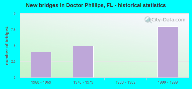
- New bridges - historical statistics
- 41960-1969
- 51970-1979
- 81990-1999

- Reconstructed bridges - Historical Statistics
- 11970-1979
- 01980-1989
- 11990-1999


- Bridge Condition - Deck
- 85.7%Good
- 14.3%Satisfactory

- Bridge Condition - Superstructure
- 85.7%Good
- 14.3%Satisfactory

- Bridge Condition - Substructure
- 71.4%Good
- 28.6%Satisfactory
Find on map >> Show street view
Structure Number: 750087, Location: I-4 & SR 528 Interchange (Lat: 28.421781, Lng: -81.474586), Route carried "on" structure: Ramp State highway 528, Year Built: 1973, Status: Open, Structure Length: 18.93m (62.11ft), Average Daily Traffic: 18,500 (year 2020), Truck Traffic: 12%, Average Future Daily Traffic: 32,098 (year 2042), Design Load: HS 20+Mod, Features Intersected: INTERSTATE 4 SR 400
Minimum Vertical Clearance: 30+ m (98+ ft), Kilometerpoint: 0.000, Lanes on structure: 2, Lanes under structure: 7, Toll: On toll road, Owner: State Toll Authority, Approaching Roadway Width: 12.8m (42.0ft), Skew: 9 degrees, Material/Design: Prestressed concrete, Design/Construction: Stringer/Multi-beam, Number Of Spans In Main Unit: 8, Length of Maximum Span: 30.9m (101.4ft), Curb-To-Curb Width: 12.2m (40.0ft), Out-to-Out Width: 13.1m (43.0ft)
Condition: Deck: Good, Superstructure: Satisfactory, Substructure: Satisfactory, Operating Rating: 40.7 metric tons, Method Used To Determine Operating Rating: Load and Resistance Factor (LRFR), Inventory Rating: 32.7 metric tons, Method Used To Determine Inventory Rating: Load and Resistance Factor (LRFR), Structural Evaluation: Equal to present minimum criteria, Deck Geometry: Superior to present desirable criteria, Underclear: Somewhat better than minimum adequacy, Approach Roadway Alignment: Equal to present minimum criteria, Designated Inspection Frequency: Every 24 months, Inspection Date: December 2021, Deck Structure Type: Concrete Cast-file-Place
Find on map >> Show street view
Structure Number: 750142, Location: I-4 WB - Central Fl Pkwy (Lat: 28.410314, Lng: -81.475558), Route carried "on" structure: Interstate 4, Year Built: 1960, Year Reconstructed: 1979, Status: Open, Structure Length: 2.71m (8.89ft), Average Daily Traffic: 97,000 (year 2020), Truck Traffic: 8%, Average Future Daily Traffic: 168,295 (year 2042), Design Load: HS 20+Mod, Features Intersected: Central Fl Pkwy
Minimum Vertical Clearance: 30+ m (98+ ft), Kilometerpoint: 8.861, Lanes on structure: 4, Lanes under structure: 4, Base Highway Network: Yes, Owner: State Highway Agency, Approaching Roadway Width: 19.9m (65.3ft), Material/Design: Prestressed concrete, Design/Construction: Stringer/Multi-beam, Number Of Spans In Main Unit: 1, Length of Maximum Span: 26.5m (86.9ft), Curb-To-Curb Width: 21.0m (68.9ft), Out-to-Out Width: 21.6m (70.9ft)
Condition: Deck: Satisfactory, Superstructure: Good, Substructure: Good, Operating Rating: 31.7 metric tons, Method Used To Determine Operating Rating: Load and Resistance Factor (LRFR), Inventory Rating: 28.1 metric tons, Method Used To Determine Inventory Rating: Load and Resistance Factor (LRFR), Structural Evaluation: Better than present minimum criteria, Deck Geometry: Better than present minimum criteria, Underclear: High priority of corrective action, Approach Roadway Alignment: Equal to present desirable criteria, Length Of Structure Improvement: 1.79m (5.87ft), Designated Inspection Frequency: Every 24 months, Inspection Date: June 2020, Bridge Improvement Cost: $20,000, Total Project Cost: $66,000, Deck Structure Type: Concrete Cast-file-Place, Wearing Surface/Protective System: Wearing Surface: Monolithic Concrete
Find on map >> Show street view
Structure Number: 75018, Location: I-4 & SR 528 INTERSECTION (Lat: 28.420178, Lng: -81.474250), Route carried "on" structure: Ramp State highway 528, Year Built: 1973, Status: Open, Structure Length: 9.36m (30.71ft), Average Daily Traffic: 17,500 (year 2020), Truck Traffic: 12%, Average Future Daily Traffic: 30,362 (year 2042), Design Load: HS 20+Mod, Features Intersected: INTERSTATE 4 SR 400
Minimum Vertical Clearance: 30+ m (98+ ft), Kilometerpoint: 0.378, Lanes on structure: 1, Lanes under structure: 6, Toll: On toll road, Owner: State Toll Authority, Approaching Roadway Width: 7.7m (25.3ft), Skew: 9 degrees, Material/Design: Prestressed concrete, Design/Construction: Stringer/Multi-beam, Number Of Spans In Main Unit: 4, Length of Maximum Span: 32.6m (107.0ft), Curb-To-Curb Width: 8.3m (27.2ft), Out-to-Out Width: 9.2m (30.2ft)
Condition: Deck: Good, Superstructure: Good, Substructure: Satisfactory, Operating Rating: 39.6 metric tons, Method Used To Determine Operating Rating: Load and Resistance Factor (LRFR), Inventory Rating: 30.5 metric tons, Method Used To Determine Inventory Rating: Load and Resistance Factor (LRFR), Structural Evaluation: Equal to present minimum criteria, Deck Geometry: Superior to present desirable criteria, Underclear: Somewhat better than minimum adequacy, Approach Roadway Alignment: Better than present minimum criteria, Designated Inspection Frequency: Every 24 months, Inspection Date: December 2021, Deck Structure Type: Concrete Cast-file-Place
Find on map >> Show street view
Structure Number: 7502, Location: I-4 EB - Central Fl Pkwy (Lat: 28.410197, Lng: -81.475306), Route carried "on" structure: Interstate 4, Year Built: 1960, Year Reconstructed: 2002, Status: Open, Structure Length: 2.69m (8.83ft), Average Daily Traffic: 97,000 (year 2020), Truck Traffic: 8%, Average Future Daily Traffic: 168,295 (year 2042), Design Load: HS 20+Mod, Features Intersected: Central Fl Parkway
Minimum Vertical Clearance: 30+ m (98+ ft), Kilometerpoint: 8.861, Lanes on structure: 4, Lanes under structure: 4, Base Highway Network: Yes, Owner: State Highway Agency, Approaching Roadway Width: 20.7m (67.9ft), Material/Design: Prestressed concrete, Design/Construction: Stringer/Multi-beam, Number Of Spans In Main Unit: 1, Length of Maximum Span: 26.2m (86.0ft), Curb-To-Curb Width: 20.7m (67.9ft), Out-to-Out Width: 24.4m (80.1ft)
Condition: Deck: Good, Superstructure: Good, Substructure: Good, Operating Rating: 31.7 metric tons, Method Used To Determine Operating Rating: Load and Resistance Factor (LRFR), Inventory Rating: 28.1 metric tons, Method Used To Determine Inventory Rating: Load and Resistance Factor (LRFR), Structural Evaluation: Better than present minimum criteria, Deck Geometry: Equal to present minimum criteria, Underclear: High priority of corrective action, Approach Roadway Alignment: Equal to present desirable criteria, Designated Inspection Frequency: Every 24 months, Inspection Date: June 2020, Deck Structure Type: Concrete Cast-file-Place, Wearing Surface/Protective System: Wearing Surface: Bituminous
Find on map >> Show street view
Structure Number: 750335, Location: I-4 WB - SR-482 (Lat: 28.449981, Lng: -81.474528), Route carried "on" structure: Interstate 4, Year Built: 1991, Status: Open, Structure Length: 5.09m (16.70ft), Average Daily Traffic: 50,000 (year 2020), Truck Traffic: 4%, Average Future Daily Traffic: 86,750 (year 2042), Design Load: HS 20+Mod, Features Intersected: SR-482
Minimum Vertical Clearance: 30+ m (98+ ft), Kilometerpoint: 13.279, Lanes on structure: 5, Lanes under structure: 10, Base Highway Network: Yes, Owner: State Highway Agency, Approaching Roadway Width: 24.9m (81.7ft), Material/Design: Steel, Design/Construction: Stringer/Multi-beam, Number Of Spans In Main Unit: 1, Length of Maximum Span: 50.3m (165.0ft), Curb-To-Curb Width: 24.9m (81.7ft), Out-to-Out Width: 25.9m (85.0ft)
Condition: Deck: Good, Superstructure: Good, Substructure: Good, Operating Rating: 60.4 metric tons, Method Used To Determine Operating Rating: Load Factor (LF), Inventory Rating: 36.2 metric tons, Method Used To Determine Inventory Rating: Load Factor (LF), Structural Evaluation: Better than present minimum criteria, Deck Geometry: Better than present minimum criteria, Underclear: Equal to present minimum criteria, Approach Roadway Alignment: Equal to present desirable criteria, Designated Inspection Frequency: Every 24 months, Inspection Date: May 2020, Deck Structure Type: Concrete Cast-file-Place, Wearing Surface/Protective System: Wearing Surface: Monolithic Concrete
Find on map >> Show street view
Structure Number: 750336, Location: I-4 EB - SR-482 (Lat: 28.449992, Lng: -81.474119), Route carried "on" structure: Interstate 4, Year Built: 1991, Status: Open, Structure Length: 5.08m (16.67ft), Average Daily Traffic: 50,000 (year 2020), Truck Traffic: 4%, Average Future Daily Traffic: 86,750 (year 2042), Design Load: HS 20+Mod, Features Intersected: SR-482
Minimum Vertical Clearance: 30+ m (98+ ft), Kilometerpoint: 13.279, Lanes on structure: 3, Lanes under structure: 10, Base Highway Network: Yes, Owner: State Highway Agency, Approaching Roadway Width: 16.6m (54.5ft), Material/Design: Steel, Design/Construction: Stringer/Multi-beam, Number Of Spans In Main Unit: 1, Length of Maximum Span: 50.2m (164.7ft), Curb-To-Curb Width: 17.0m (55.8ft), Out-to-Out Width: 17.9m (58.7ft)
Condition: Deck: Good, Superstructure: Good, Substructure: Good, Operating Rating: 64.6 metric tons, Method Used To Determine Operating Rating: Load Factor (LF), Inventory Rating: 38.7 metric tons, Method Used To Determine Inventory Rating: Load Factor (LF), Structural Evaluation: Better than present minimum criteria, Deck Geometry: Equal to present minimum criteria, Underclear: Equal to present minimum criteria, Approach Roadway Alignment: Equal to present desirable criteria, Designated Inspection Frequency: Every 24 months, Inspection Date: May 2020, Deck Structure Type: Concrete Cast-file-Place, Wearing Surface/Protective System: Wearing Surface: Monolithic Concrete
Find on map >> Show street view
Structure Number: 750402, Location: Central Fl Pkwy Ramp- I-4 (Lat: 28.409664, Lng: -81.475419), Route carried "on" structure: Ramp Other road 4, Year Built: 1990, Status: Open, Structure Length: 38.07m (124.90ft), Average Daily Traffic: 9,400 (year 2020), Truck Traffic: 7%, Average Future Daily Traffic: 16,309 (year 2042), Design Load: HS 20, Features Intersected: I-4, Facility Carried by Structure: Central Fl Parkway
Minimum Vertical Clearance: 30+ m (98+ ft), Kilometerpoint: 0.116, Lanes on structure: 1, Lanes under structure: 11, Base Highway Network: Yes, Owner: State Highway Agency, Approaching Roadway Width: 9.4m (30.8ft), Material/Design: Steel continuous, Design/Construction: Box Beam or Girders - Single/Spread, Number Of Spans In Main Unit: 8, Length of Maximum Span: 56.8m (186.4ft), Curb-To-Curb Width: 8.2m (26.9ft), Out-to-Out Width: 9.1m (29.9ft)
Condition: Deck: Good, Superstructure: Good, Substructure: Good, Operating Rating: 75.4 metric tons, Method Used To Determine Operating Rating: Load Factor (LF), Inventory Rating: 45.0 metric tons, Method Used To Determine Inventory Rating: Load Factor (LF), Structural Evaluation: Better than present minimum criteria, Deck Geometry: Superior to present desirable criteria, Underclear: High priority of corrective action, Approach Roadway Alignment: Better than present minimum criteria, Designated Inspection Frequency: Every 24 months, Critical Feature Inspection Frequency: Every 24 months, Inspection Date: November 2020, Critical Feature Inspection Date: November 2020, Deck Structure Type: Concrete Cast-file-Place, Wearing Surface/Protective System: Wearing Surface: Monolithic Concrete
Find on map >> Show street view
Structure Number: 750087, Location: I-4 & SR 528 Interchange (Lat: 28.421781, Lng: -81.474586), Route carried "under" structure: Ramp State highway 528, Year Built: 1973, Structure Length: 0. m, Average Daily Traffic: 17,500 (year 2020), Truck Traffic: 12%, Features Intersected: INTERSTATE 4 SR 400
Minimum Vertical Clearance: 4.97m (16.31ft), Kilometerpoint: 0.246, Lanes on structure: 2, Lanes under structure: 1, Toll: On toll road, Material/Design: Prestressed concrete, Design/Construction: Stringer/Multi-beam, Length of Maximum Span: 30.9m (101.4ft)
Find on map >> Show street view
Structure Number: 750087, Location: I-4 & SR 528 Interchange (Lat: 28.421781, Lng: -81.474586), Route carried "under" structure: Interstate 4, Year Built: 1973, Structure Length: 0. m, Average Daily Traffic: 194,000 (year 2020), Truck Traffic: 8%, Features Intersected: INTERSTATE 4 SR 400, Facility Carried by Structure: SR528 EXIT RMP 0.0
Minimum Vertical Clearance: 5.72m (18.77ft), Kilometerpoint: 10.203, Lanes on structure: 2, Lanes under structure: 6, Material/Design: Prestressed concrete, Design/Construction: Stringer/Multi-beam, Length of Maximum Span: 30.9m (101.4ft)
Find on map >> Show street view
Structure Number: 750142, Location: I-4 WB - Central Fl Pkwy (Lat: 28.410314, Lng: -81.475558), Route carried "under" structure: County highway , Year Built: 1960, Structure Length: 0. m, Average Daily Traffic: 17,900 (year 2020), Truck Traffic: 7%, Features Intersected: Central Fl Pkwy, Facility Carried by Structure: I-4 WB
Minimum Vertical Clearance: 5.03m (16.50ft), Kilometerpoint: 0.179, Lanes on structure: 4, Lanes under structure: 4, Material/Design: Prestressed concrete, Design/Construction: Stringer/Multi-beam, Length of Maximum Span: 26.5m (86.9ft)
Find on map >> Show street view
Structure Number: 75018, Location: I-4 & SR 528 INTERSECTION (Lat: 28.420178, Lng: -81.474250), Route carried "under" structure: Interstate 4, Year Built: 1973, Structure Length: 0. m, Average Daily Traffic: 194,000 (year 2020), Truck Traffic: 8%, Features Intersected: INTERSTATE 4 SR 400, Facility Carried by Structure: SR 528 RAMP 0.0
Minimum Vertical Clearance: 5.00m (16.40ft), Kilometerpoint: 9.992, Lanes on structure: 1, Lanes under structure: 6, Material/Design: Prestressed concrete, Design/Construction: Stringer/Multi-beam, Length of Maximum Span: 32.6m (107.0ft)
Find on map >> Show street view
Structure Number: 7502, Location: I-4 EB - Central Fl Pkwy (Lat: 28.410197, Lng: -81.475306), Route carried "under" structure: County highway , Year Built: 1960, Structure Length: 0. m, Average Daily Traffic: 17,900 (year 2020), Truck Traffic: 7%, Features Intersected: Central Fl Parkway, Facility Carried by Structure: I-4 EB
Minimum Vertical Clearance: 5.24m (17.19ft), Kilometerpoint: 0.225, Lanes on structure: 4, Lanes under structure: 4, Material/Design: Prestressed concrete, Design/Construction: Stringer/Multi-beam, Length of Maximum Span: 26.2m (86.0ft)
Find on map >> Show street view
Structure Number: 750335, Location: I-4 WB - SR-482 (Lat: 28.449981, Lng: -81.474528), Route carried "under" structure: State highway 482, Year Built: 1991, Structure Length: 0. m, Average Daily Traffic: 28,500 (year 2020), Truck Traffic: 5%, Features Intersected: SR-482, Facility Carried by Structure: I-4 WB
Minimum Vertical Clearance: 5.15m (16.90ft), Kilometerpoint: 0.195, Lanes on structure: 5, Lanes under structure: 10, Material/Design: Steel, Design/Construction: Stringer/Multi-beam, Length of Maximum Span: 50.3m (165.0ft)
Find on map >> Show street view
Structure Number: 750336, Location: I-4 EB - SR-482 (Lat: 28.449992, Lng: -81.474119), Route carried "under" structure: State highway 482, Year Built: 1991, Structure Length: 0. m, Average Daily Traffic: 28,500 (year 2020), Truck Traffic: 5%, Features Intersected: SR-482, Facility Carried by Structure: I-4 EB
Minimum Vertical Clearance: 5.33m (17.49ft), Kilometerpoint: 0.233, Lanes on structure: 3, Lanes under structure: 10, Material/Design: Steel, Design/Construction: Stringer/Multi-beam, Length of Maximum Span: 50.2m (164.7ft)
Find on map >> Show street view
Structure Number: 750402, Location: Central Fl Pkwy Ramp- I-4 (Lat: 28.409664, Lng: -81.475419), Route carried "under" structure: Ramp Other road , Year Built: 1990, Structure Length: 0. m, Average Daily Traffic: 1,200 (year 2020), Truck Traffic: 1%, Features Intersected: I-4, Facility Carried by Structure: Central Fl Parkway
Minimum Vertical Clearance: 11.25m (36.91ft), Kilometerpoint: 0.000, Lanes on structure: 1, Lanes under structure: 1, Material/Design: Steel continuous, Design/Construction: Box Beam or Girders - Single/Spread, Length of Maximum Span: 56.8m (186.4ft)
Find on map >> Show street view
Structure Number: 750402, Location: Central Fl Pkwy Ramp- I-4 (Lat: 28.409664, Lng: -81.475419), Route carried "under" structure: City street , Year Built: 1990, Structure Length: 0. m, Average Daily Traffic: 3,000 (year 2020), Truck Traffic: 1%, Features Intersected: I-4, Facility Carried by Structure: Central Fl Parkway
Minimum Vertical Clearance: 6.68m (21.92ft), Kilometerpoint: 0.000, Lanes on structure: 1, Lanes under structure: 2, Material/Design: Steel continuous, Design/Construction: Box Beam or Girders - Single/Spread, Length of Maximum Span: 56.8m (186.4ft)
Find on map >> Show street view
Structure Number: 750402, Location: Central Fl Pkwy Ramp- I-4 (Lat: 28.409664, Lng: -81.475419), Route carried "under" structure: Interstate 4, Year Built: 1990, Structure Length: 0. m, Average Daily Traffic: 10,500 (year 2020), Truck Traffic: 6%, Features Intersected: I-4, Facility Carried by Structure: Central Fl Parkway
Minimum Vertical Clearance: 5.97m (19.59ft), Kilometerpoint: 0.027, Lanes on structure: 1, Lanes under structure: 8, Material/Design: Steel continuous, Design/Construction: Box Beam or Girders - Single/Spread, Length of Maximum Span: 56.8m (186.4ft)