Bridge Statistics for Donnelly, Idaho (ID)
Condition, Traffic, Stress, Structural Evaluation, Project Costs
- National Bridge Inventory (NBI) Statistics
- 16Number of bridges
- 161ft / 48.9mTotal length
- $3,597,000Total costs
- 50,790Total average daily traffic
- 3,145Total average daily truck traffic
- 76,185Total future (year 2039) average daily traffic
- National Bridge Inventory (NBI) Registered Bridges for Donnelly
- No street view available for this location
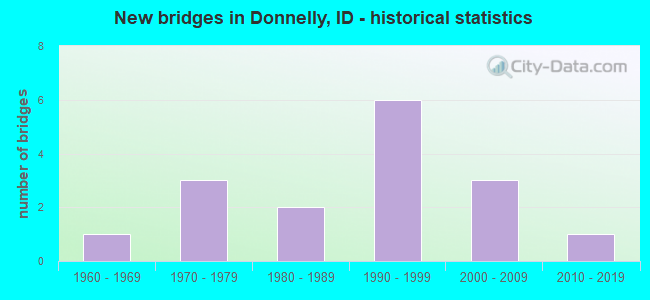
- New bridges - historical statistics
- 11960-1969
- 31970-1979
- 21980-1989
- 61990-1999
- 32000-2009
- 12010-2019


- Bridge Condition - Deck
- 30.0%Good
- 60.0%Satisfactory
- 10.0%Fair

- Bridge Condition - Superstructure
- 30.0%Very good
- 40.0%Good
- 20.0%Satisfactory
- 10.0%Fair

- Bridge Condition - Substructure
- 10.0%Excellent
- 20.0%Very good
- 30.0%Good
- 30.0%Satisfactory
- 10.0%Fair

- Bridge Condition - Channel
- 6.3%Excellent
- 31.3%Very good
- 31.3%Good
- 25.0%Satisfactory
- 6.3%Fair

- Bridge Condition - Culverts
- 33.3%Satisfactory
- 33.3%Fair
- 33.3%Poor
Find on map >> Show street view
Structure Number: 14841, Location: 2.0 S DONNELLY (Lat: 44.698600, Lng: -116.051700), Route carried "on" structure: State highway 55, Year Built: 2016, Status: Open, Structure Length: 4.66m (15.29ft), Average Daily Traffic: 4,000 (year 2019), Truck Traffic: 10%, Average Future Daily Traffic: 6,000 (year 2039), Design Load: HL 93, Features Intersected: GOLD FORK RIVER
Minimum Vertical Clearance: 30+ m (98+ ft), Kilometerpoint: 207.132, Lanes on structure: 2, Base Highway Network: Yes (Inventory Route: SH0, Subroute: 1), Owner: State Highway Agency, Approaching Roadway Width: 11.6m (38.1ft), Material/Design: Prestressed concrete, Design/Construction: Stringer/Multi-beam, Number Of Spans In Main Unit: 1, Length of Maximum Span: 46.0m (150.9ft), Curb-To-Curb Width: 13.5m (44.3ft), Out-to-Out Width: 14.6m (47.9ft)
Condition: Deck: Good, Superstructure: Good, Substructure: Excellent, Channel: Excellent, Operating Rating: 64.5 metric tons, Method Used To Determine Operating Rating: Load and Resistance Factor Rating (LRFR) rating reported by rating factor(RF) method using HL-93 loadings, Inventory Rating: 43.7 metric tons, Method Used To Determine Inventory Rating: Load and Resistance Factor Rating (LRFR) rating reported by rating factor(RF) method using HL-93 loadings, Structural Evaluation: Better than present minimum criteria, Deck Geometry: Superior to present desirable criteria, Waterway Adequacy: Equal to present desirable criteria, Approach Roadway Alignment: Equal to present desirable criteria, Designated Inspection Frequency: Every 48 months, Inspection Date: May 2018, Deck Structure Type: Concrete Cast-file-Place, Wearing Surface/Protective System: Wearing Surface: Low Slump Concrete, Deck Protection: Epoxy Coated Reinforcing
Find on map >> Show street view
Structure Number: 14851, Location: AT DONNELLY SCL (Lat: 44.726917, Lng: -116.074361), Route carried "on" structure: State highway 55, Year Built: 1999, Status: Open, Structure Length: 1.74m (5.71ft), Average Daily Traffic: 4,900 (year 2019), Truck Traffic: 15%, Average Future Daily Traffic: 7,350 (year 2039), Design Load: HS 25 or greater, Features Intersected: BOULDER CREEK
Minimum Vertical Clearance: 30+ m (98+ ft), Kilometerpoint: 210.804, Lanes on structure: 2, Base Highway Network: Yes (Inventory Route: SH0, Subroute: 1), Owner: State Highway Agency, Approaching Roadway Width: 10.8m (35.4ft), Material/Design: Prestressed concrete, Design/Construction: Stringer/Multi-beam, Number Of Spans In Main Unit: 1, Length of Maximum Span: 16.8m (55.1ft), Curb or Sidewalk Widths: Left: 1.5m (4.9ft), Right: 0.0m, Curb-To-Curb Width: 10.8m (35.4ft), Out-to-Out Width: 13.0m (42.7ft)
Condition: Deck: Satisfactory, Superstructure: Very good, Substructure: Very good, Channel: Very good, Operating Rating: 70.8 metric tons, Method Used To Determine Operating Rating: Load Factor (LF), Inventory Rating: 42.6 metric tons, Method Used To Determine Inventory Rating: Load Factor (LF), Structural Evaluation: Equal to present desirable criteria, Deck Geometry: Somewhat better than minimum adequacy, Waterway Adequacy: Equal to present desirable criteria, Approach Roadway Alignment: Equal to present desirable criteria, Designated Inspection Frequency: Every 48 months, Inspection Date: May 2020, Deck Structure Type: Concrete Cast-file-Place, Wearing Surface/Protective System: Wearing Surface: Monolithic Concrete, Deck Protection: Epoxy Coated Reinforcing
Find on map >> Show street view
Structure Number: 14865, Location: 2.9 S. LAKE FORK (Lat: 44.788722, Lng: -116.077194), Route carried "on" structure: State highway 55, Year Built: 1985, Status: Open, Structure Length: 2.90m (9.51ft), Average Daily Traffic: 6,000 (year 2019), Truck Traffic: 11%, Average Future Daily Traffic: 9,000 (year 2039), Design Load: HS 25 or greater, Features Intersected: LAKE FORK CREEK
Minimum Vertical Clearance: 30+ m (98+ ft), Kilometerpoint: 217.816, Lanes on structure: 2, Base Highway Network: Yes (Inventory Route: SH0, Subroute: 1), Owner: State Highway Agency, Approaching Roadway Width: 10.4m (34.1ft), Material/Design: Prestressed concrete, Design/Construction: Stringer/Multi-beam, Number Of Spans In Main Unit: 1, Length of Maximum Span: 28.2m (92.5ft), Curb-To-Curb Width: 13.0m (42.7ft), Out-to-Out Width: 13.9m (45.6ft)
Condition: Deck: Satisfactory, Superstructure: Good, Substructure: Satisfactory, Channel: Very good, Operating Rating: 81.6 metric tons, Method Used To Determine Operating Rating: Load Factor (LF), Inventory Rating: 49.9 metric tons, Method Used To Determine Inventory Rating: Load Factor (LF), Structural Evaluation: Equal to present minimum criteria, Deck Geometry: Somewhat better than minimum adequacy, Waterway Adequacy: Equal to present desirable criteria, Approach Roadway Alignment: Equal to present desirable criteria, Designated Inspection Frequency: Every 48 months, Inspection Date: May 2020, Deck Structure Type: Concrete Cast-file-Place, Wearing Surface/Protective System: Wearing Surface: Monolithic Concrete, Deck Protection: Epoxy Coated Reinforcing
Find on map >> Show street view
Structure Number: 18996, Location: IN BOISE; NWCL (Lat: 43.618472, Lng: -116.234028), Route carried "on" structure: Ramp Interstate 184, Year Built: 1991, Status: Open, Structure Length: 18.96m (62.20ft), Average Daily Traffic: 30,000 (year 2019), Truck Traffic: 3%, Average Future Daily Traffic: 45,000 (year 2039), Design Load: HS 25 or greater, Features Intersected: US 20-26;BOISE RV SLOUGH
Minimum Vertical Clearance: 30+ m (98+ ft), Kilometerpoint: 5.729, Lanes on structure: 3, Lanes under structure: 8, Base Highway Network: Yes, Owner: State Highway Agency, Approaching Roadway Width: 16.0m (52.5ft), Material/Design: Prestressed concrete continuous, Design/Construction: Box Beam or Girders - Single/Spread, Number Of Spans In Main Unit: 5, Length of Maximum Span: 45.7m (149.9ft), Curb-To-Curb Width: 16.0m (52.5ft), Out-to-Out Width: 16.9m (55.4ft)
Condition: Deck: Satisfactory, Superstructure: Satisfactory, Substructure: Good, Channel: Very good, Operating Rating: 63.5 metric tons, Method Used To Determine Operating Rating: Load and Resistance Factor (LRFR), Inventory Rating: 33.6 metric tons, Method Used To Determine Inventory Rating: Load and Resistance Factor (LRFR), Structural Evaluation: Equal to present minimum criteria, Deck Geometry: Superior to present desirable criteria, Underclear: High priority of corrective action, Waterway Adequacy: Superior to present desirable criteria, Approach Roadway Alignment: Equal to present desirable criteria, Designated Inspection Frequency: Every 48 months, Inspection Date: June 2020, Deck Structure Type: Concrete Cast-file-Place, Wearing Surface/Protective System: Wearing Surface: Latex Concrete, Deck Protection: Epoxy Coated Reinforcing
Find on map >> Show street view
Structure Number: 20068, Location: 1.5 E. DONNELLY (Lat: 44.731056, Lng: -116.048889), Route carried "on" structure: County highway 3988, Year Built: 1996, Status: Open, Structure Length: 0.91m (2.99ft), Average Daily Traffic: 370 (year 2019), Truck Traffic: 8%, Average Future Daily Traffic: 555 (year 2039), Design Load: HS 20, Features Intersected: WILLOW CREEK
Minimum Vertical Clearance: 30+ m (98+ ft), Kilometerpoint: 0.084, Lanes on structure: 2, Owner: County Highway Agency, Approaching Roadway Width: 6.7m (22.0ft), Material/Design: Steel, Design/Construction: Culvert, Number Of Spans In Main Unit: 4, Length of Maximum Span: 1.8m (5.9ft), Curb-To-Curb Width: 8.5m (27.9ft), Out-to-Out Width: 18.6m (61.0ft)
Condition: Channel: Good, Culverts: Poor, Structural Evaluation: Meets minimum limits, Deck Geometry: Equal to present minimum criteria, Waterway Adequacy: Equal to present minimum criteria, Approach Roadway Alignment: Equal to present desirable criteria, Length Of Structure Improvement: 1.55m (5.09ft), Designated Inspection Frequency: Every 12 months, Inspection Date: August 2021, Bridge Improvement Cost: $219,000, Roadway Improvement Cost: $22,000, Total Project Cost: $329,000 ( Estimate for 2017)
Find on map >> Show street view
Structure Number: 20075, Location: 0.8 W. DONNELLY (Lat: 44.730556, Lng: -116.096889), Route carried "on" structure: County highway 3988, Year Built: 1965, Status: Open, Structure Length: 3.14m (10.30ft), Average Daily Traffic: 1,700 (year 2019), Truck Traffic: 2%, Average Future Daily Traffic: 2,550 (year 2039), Design Load: HS 20, Features Intersected: LAKE FORK
Minimum Vertical Clearance: 30+ m (98+ ft), Kilometerpoint: 3.941, Lanes on structure: 2, Owner: County Highway Agency, Approaching Roadway Width: 8.2m (26.9ft), Material/Design: Prestressed concrete, Design/Construction: Stringer/Multi-beam, Number Of Spans In Main Unit: 2, Length of Maximum Span: 15.2m (49.9ft), Curb or Sidewalk Widths: Left: 0.6m (2.0ft), Right: 0.6m (2.0ft), Curb-To-Curb Width: 6.7m (22.0ft), Out-to-Out Width: 8.3m (27.2ft)
Condition: Deck: Fair, Superstructure: Good, Substructure: Satisfactory, Channel: Good, Operating Rating: 47.2 metric tons, Method Used To Determine Operating Rating: Field evaluation and documented engineering judgment, Inventory Rating: 28.1 metric tons, Method Used To Determine Inventory Rating: Field evaluation and documented engineering judgment, Structural Evaluation: Equal to present minimum criteria, Deck Geometry: High priority of corrective action, Waterway Adequacy: Better than present minimum criteria, Approach Roadway Alignment: Equal to present minimum criteria, Length Of Structure Improvement: 4.02m (13.19ft), Designated Inspection Frequency: Every 24 months, Underwater Inspection Frequency: Every 60 months, Inspection Date: August 2021, Underwater Inspection Date: August 2017, Bridge Improvement Cost: $915,000, Roadway Improvement Cost: $92,000, Total Project Cost: $1,373,000 ( Estimate for 2021), Deck Structure Type: Concrete Cast-file-Place, Wearing Surface/Protective System: Wearing Surface: Monolithic Concrete
Find on map >> Show street view
Structure Number: 2008, Location: 1.3 S. 2.8 W. DONNELLY (Lat: 44.712333, Lng: -116.136389), Route carried "on" structure: County highway 3938, Year Built: 1975, Status: Open, Structure Length: 4.94m (16.21ft), Average Daily Traffic: 830 (year 2019), Truck Traffic: 4%, Average Future Daily Traffic: 1,245 (year 2039), Design Load: HS 20, Features Intersected: CASCADE RESERVOIR
Minimum Vertical Clearance: 30+ m (98+ ft), Kilometerpoint: 40.306, Lanes on structure: 2, Owner: County Highway Agency, Approaching Roadway Width: 8.5m (27.9ft), Material/Design: Prestressed concrete, Design/Construction: Stringer/Multi-beam, Number Of Spans In Main Unit: 2, Length of Maximum Span: 23.8m (78.1ft), Curb-To-Curb Width: 9.2m (30.2ft), Out-to-Out Width: 9.4m (30.8ft)
Condition: Deck: Satisfactory, Superstructure: Good, Substructure: Fair, Channel: Satisfactory, Operating Rating: 59.0 metric tons, Method Used To Determine Operating Rating: Load Factor (LF), Inventory Rating: 35.4 metric tons, Method Used To Determine Inventory Rating: Load Factor (LF), Structural Evaluation: Somewhat better than minimum adequacy, Deck Geometry: Equal to present minimum criteria, Waterway Adequacy: Equal to present desirable criteria, Approach Roadway Alignment: Better than present minimum criteria, Designated Inspection Frequency: Every 24 months, Underwater Inspection Frequency: Every 60 months, Inspection Date: August 2021, Underwater Inspection Date: August 2017, Deck Structure Type: Concrete Cast-file-Place, Wearing Surface/Protective System: Wearing Surface: Monolithic Concrete
Find on map >> Show street view
Structure Number: 20086, Location: 0.2 S. 1.5 W. DONNELLY (Lat: 44.727500, Lng: -116.108889), Route carried "on" structure: County highway , Year Built: 2004, Status: Open, Structure Length: 1.62m (5.31ft), Average Daily Traffic: 570 (year 2019), Truck Traffic: 11%, Average Future Daily Traffic: 855 (year 2039), Design Load: HS 20, Features Intersected: MUD CREEK, Facility Carried by Structure: NORWOOD RD
Minimum Vertical Clearance: 30+ m (98+ ft), Kilometerpoint: 44.008, Lanes on structure: 2, Owner: County Highway Agency, Approaching Roadway Width: 9.1m (29.9ft), Material/Design: Steel, Design/Construction: Stringer/Multi-beam, Number Of Spans In Main Unit: 1, Length of Maximum Span: 15.2m (49.9ft), Curb-To-Curb Width: 9.8m (32.2ft), Out-to-Out Width: 10.4m (34.1ft)
Condition: Deck: Good, Superstructure: Very good, Substructure: Good, Channel: Good, Operating Rating: 78.9 metric tons, Method Used To Determine Operating Rating: Load Factor (LF), Inventory Rating: 47.2 metric tons, Method Used To Determine Inventory Rating: Load Factor (LF), Structural Evaluation: Better than present minimum criteria, Deck Geometry: Equal to present minimum criteria, Waterway Adequacy: Superior to present desirable criteria, Approach Roadway Alignment: Equal to present desirable criteria, Length Of Structure Improvement: 2.32m (7.61ft), Designated Inspection Frequency: Every 48 months, Inspection Date: August 2020, Bridge Improvement Cost: $426,000, Roadway Improvement Cost: $43,000, Total Project Cost: $639,000, Deck Structure Type: Open Grating
Find on map >> Show street view
Structure Number: 28561, Location: 0.5 N. 1.5 E. DONNELLY (Lat: 44.735639, Lng: -116.047639), Route carried "on" structure: County highway 3944, Year Built: 1996, Status: Open, Structure Length: 0.73m (2.40ft), Average Daily Traffic: 320 (year 2019), Truck Traffic: 9%, Average Future Daily Traffic: 480 (year 2039), Design Load: HS 20, Features Intersected: WILLOW CREEK
Minimum Vertical Clearance: 30+ m (98+ ft), Kilometerpoint: 168.548, Lanes on structure: 2, Owner: County Highway Agency, Approaching Roadway Width: 6.7m (22.0ft), Material/Design: Steel, Design/Construction: Culvert, Number Of Spans In Main Unit: 3, Length of Maximum Span: 2.1m (6.9ft), Curb-To-Curb Width: 8.5m (27.9ft), Out-to-Out Width: 18.9m (62.0ft)
Condition: Channel: Fair, Culverts: Fair, Structural Evaluation: Somewhat better than minimum adequacy, Deck Geometry: Equal to present minimum criteria, Waterway Adequacy: Better than present minimum criteria, Approach Roadway Alignment: Equal to present desirable criteria, Designated Inspection Frequency: Every 24 months, Inspection Date: August 2020
Find on map >> Show street view
Structure Number: 28568, Location: 1.6 W. DONNELLY (Lat: 44.731139, Lng: -116.110500), Route carried "on" structure: County highway 3938, Year Built: 2004, Status: Open, Structure Length: 1.65m (5.41ft), Average Daily Traffic: 860 (year 2019), Truck Traffic: 4%, Average Future Daily Traffic: 1,290 (year 2039), Design Load: HS 20, Features Intersected: MUD CREEK
Minimum Vertical Clearance: 30+ m (98+ ft), Kilometerpoint: 162.370, Lanes on structure: 2, Owner: County Highway Agency, Approaching Roadway Width: 9.8m (32.2ft), Material/Design: Steel, Design/Construction: Stringer/Multi-beam, Number Of Spans In Main Unit: 1, Length of Maximum Span: 15.2m (49.9ft), Curb-To-Curb Width: 9.8m (32.2ft), Out-to-Out Width: 10.4m (34.1ft)
Condition: Deck: Good, Superstructure: Very good, Substructure: Very good, Channel: Very good, Operating Rating: 78.9 metric tons, Method Used To Determine Operating Rating: Load Factor (LF), Inventory Rating: 47.2 metric tons, Method Used To Determine Inventory Rating: Load Factor (LF), Structural Evaluation: Equal to present desirable criteria, Deck Geometry: Equal to present minimum criteria, Waterway Adequacy: Superior to present desirable criteria, Approach Roadway Alignment: Equal to present desirable criteria, Designated Inspection Frequency: Every 48 months, Inspection Date: August 2019, Deck Structure Type: Open Grating
Find on map >> Show street view
Structure Number: 2857, Location: 2.0 N. 2.0 W. DONNELLY (Lat: 44.760361, Lng: -116.117528), Route carried "on" structure: County highway , Year Built: 1986, Status: Open, Structure Length: 1.25m (4.10ft), Average Daily Traffic: 50 (year 2019), Truck Traffic: 10%, Average Future Daily Traffic: 75 (year 2039), Design Load: HS 20, Features Intersected: MUD CREEK, Facility Carried by Structure: NISULA ROAD
Minimum Vertical Clearance: 30+ m (98+ ft), Kilometerpoint: 161.623, Lanes on structure: 2, Owner: County Highway Agency, Approaching Roadway Width: 7.3m (24.0ft), Material/Design: Steel, Design/Construction: Culvert, Number Of Spans In Main Unit: 4, Length of Maximum Span: 2.1m (6.9ft), Out-to-Out Width: 15.2m (49.9ft)
Condition: Channel: Satisfactory, Culverts: Poor, Structural Evaluation: Meets minimum limits, Waterway Adequacy: Somewhat better than minimum adequacy, Approach Roadway Alignment: Equal to present desirable criteria, Length Of Structure Improvement: 1.95m (6.40ft), Designated Inspection Frequency: Every 12 months, Inspection Date: August 2021, Bridge Improvement Cost: $253,000, Roadway Improvement Cost: $25,000, Total Project Cost: $380,000 ( Estimate for 2015)
Find on map >> Show street view
Structure Number: 28595, Location: 3.0 N. 0.5 W. DONNELLY (Lat: 44.774694, Lng: -116.084222), Route carried "on" structure: County highway , Year Built: 1976, Status: Open, Structure Length: 2.77m (9.09ft), Average Daily Traffic: 90 (year 2019), Truck Traffic: 10%, Average Future Daily Traffic: 135 (year 2039), Design Load: HS 20, Features Intersected: LAKE FORK CREEK, Facility Carried by Structure: SCHELINE LANE
Minimum Vertical Clearance: 30+ m (98+ ft), Kilometerpoint: 162.883, Lanes on structure: 2, Owner: County Highway Agency, Approaching Roadway Width: 9.4m (30.8ft), Material/Design: Prestressed concrete, Design/Construction: Tee Beam, Number Of Spans In Main Unit: 2, Length of Maximum Span: 13.7m (44.9ft), Curb-To-Curb Width: 8.1m (26.6ft), Out-to-Out Width: 8.3m (27.2ft)
Condition: Deck: Satisfactory, Superstructure: Fair, Substructure: Satisfactory, Channel: Satisfactory, Operating Rating: 45.0 metric tons, Method Used To Determine Operating Rating: Allowable Stress (AS), Inventory Rating: 32.4 metric tons, Method Used To Determine Inventory Rating: Allowable Stress (AS), Structural Evaluation: Somewhat better than minimum adequacy, Deck Geometry: Equal to present minimum criteria, Waterway Adequacy: Equal to present desirable criteria, Approach Roadway Alignment: Equal to present desirable criteria, Length Of Structure Improvement: 3.60m (11.81ft), Designated Inspection Frequency: Every 24 months, Inspection Date: August 2020, Bridge Improvement Cost: $584,000, Roadway Improvement Cost: $58,000, Total Project Cost: $876,000, Deck Structure Type: Concrete Cast-file-Place, Wearing Surface/Protective System: Wearing Surface: Bituminous
Find on map >> Show street view
Structure Number: 28628, Location: 4.0 N. 1.7 E. DONNELLY (Lat: 44.788889, Lng: -116.041667), Route carried "on" structure: County highway , Year Built: 2004, Status: Open, Structure Length: 0.76m (2.49ft), Average Daily Traffic: 230 (year 2019), Truck Traffic: 35%, Average Future Daily Traffic: 345 (year 2039), Design Load: HS 25 or greater, Features Intersected: BOULDER CREEK, Facility Carried by Structure: SPINK LANE
Minimum Vertical Clearance: 30+ m (98+ ft), Kilometerpoint: 163.926, Lanes on structure: 2, Owner: County Highway Agency, Approaching Roadway Width: 7.9m (25.9ft), Material/Design: Concrete, Design/Construction: Frame, Number Of Spans In Main Unit: 1, Length of Maximum Span: 7.6m (24.9ft), Curb-To-Curb Width: 7.7m (25.3ft), Out-to-Out Width: 9.2m (30.2ft)
Condition: Deck: Satisfactory, Superstructure: Satisfactory, Substructure: Good, Channel: Very good, Operating Rating: 86.2 metric tons, Method Used To Determine Operating Rating: Load Factor (LF), Inventory Rating: 51.7 metric tons, Method Used To Determine Inventory Rating: Load Factor (LF), Structural Evaluation: Equal to present minimum criteria, Deck Geometry: Somewhat better than minimum adequacy, Waterway Adequacy: Superior to present desirable criteria, Approach Roadway Alignment: Equal to present desirable criteria, Designated Inspection Frequency: Every 48 months, Inspection Date: August 2020, Deck Structure Type: Concrete Precast Panels, Wearing Surface/Protective System: Wearing Surface: Bituminous
Find on map >> Show street view
Structure Number: 28629, Location: 3.0 N. 1.6 E. DONNELLY (Lat: 44.774500, Lng: -116.045389), Route carried "on" structure: County highway , Year Built: 1978, Status: Open, Structure Length: 0.91m (2.99ft), Average Daily Traffic: 230 (year 2019), Truck Traffic: 35%, Average Future Daily Traffic: 345 (year 2039), Design Load: HS 20, Features Intersected: BOULDER CREEK, Facility Carried by Structure: PADDY FLAT ROAD
Minimum Vertical Clearance: 30+ m (98+ ft), Kilometerpoint: 165.955, Lanes on structure: 2, Owner: County Highway Agency, Approaching Roadway Width: 7.3m (24.0ft), Skew: 1 degrees, Material/Design: Steel, Design/Construction: Culvert, Number Of Spans In Main Unit: 3, Length of Maximum Span: 2.6m (8.5ft), Curb-To-Curb Width: 7.3m (24.0ft), Out-to-Out Width: 10.7m (35.1ft)
Condition: Channel: Good, Culverts: Fair, Operating Rating: 81.6 metric tons, Method Used To Determine Operating Rating: Load Factor (LF), Inventory Rating: 80.7 metric tons, Method Used To Determine Inventory Rating: Load Factor (LF), Structural Evaluation: Somewhat better than minimum adequacy, Deck Geometry: Somewhat better than minimum adequacy, Waterway Adequacy: Equal to present desirable criteria, Approach Roadway Alignment: Equal to present desirable criteria, Designated Inspection Frequency: Every 24 months, Inspection Date: August 2021
Find on map >> Show street view
Structure Number: 28631, Location: 2.6 N. 1.5 E. DONNELLY (Lat: 44.769000, Lng: -116.047667), Route carried "on" structure: County highway 3944, Year Built: 1996, Status: Open, Structure Length: 1.25m (4.10ft), Average Daily Traffic: 320 (year 2019), Truck Traffic: 9%, Average Future Daily Traffic: 480 (year 2039), Design Load: HS 20, Features Intersected: BOULDER CREEK
Minimum Vertical Clearance: 30+ m (98+ ft), Kilometerpoint: 172.343, Lanes on structure: 2, Owner: County Highway Agency, Approaching Roadway Width: 7.0m (23.0ft), Material/Design: Aluminum, Iron, Design/Construction: Culvert, Number Of Spans In Main Unit: 2, Length of Maximum Span: 5.2m (17.1ft), Curb-To-Curb Width: 8.4m (27.6ft), Out-to-Out Width: 11.0m (36.1ft)
Condition: Channel: Satisfactory, Culverts: Satisfactory, Inventory Rating: 62.6 metric tons, Method Used To Determine Inventory Rating: Load Factor (LF), Structural Evaluation: Equal to present minimum criteria, Deck Geometry: Somewhat better than minimum adequacy, Waterway Adequacy: Better than present minimum criteria, Approach Roadway Alignment: Equal to present desirable criteria, Designated Inspection Frequency: Every 24 months, Inspection Date: August 2020
Find on map >> Show street view
Structure Number: 28633, Location: 1.6 N. 1.5 E. DONNELLY (Lat: 44.757278, Lng: -116.047667), Route carried "on" structure: County highway 3944, Year Built: 1996, Status: Open, Structure Length: 0.67m (2.20ft), Average Daily Traffic: 320 (year 2019), Truck Traffic: 9%, Average Future Daily Traffic: 480 (year 2039), Design Load: HS 20, Features Intersected: STOVER CREEK
Minimum Vertical Clearance: 30+ m (98+ ft), Kilometerpoint: 10.105, Lanes on structure: 2, Owner: County Highway Agency, Approaching Roadway Width: 6.7m (22.0ft), Material/Design: Steel, Design/Construction: Culvert, Number Of Spans In Main Unit: 3, Length of Maximum Span: 1.8m (5.9ft), Curb-To-Curb Width: 10.4m (34.1ft), Out-to-Out Width: 15.2m (49.9ft)
Condition: Channel: Good, Culverts: Satisfactory, Operating Rating: 85.5 metric tons, Method Used To Determine Operating Rating: Load and Resistance Factor Rating (LRFR) rating reported by rating factor(RF) method using HL-93 loadings, Inventory Rating: 66.1 metric tons, Method Used To Determine Inventory Rating: Load and Resistance Factor Rating (LRFR) rating reported by rating factor(RF) method using HL-93 loadings, Structural Evaluation: Equal to present minimum criteria, Deck Geometry: Better than present minimum criteria, Waterway Adequacy: Equal to present desirable criteria, Approach Roadway Alignment: Equal to present desirable criteria, Designated Inspection Frequency: Every 24 months, Inspection Date: August 2020