Bridge Statistics for Driftwood, Pennsylvania (PA)
Condition, Traffic, Stress, Structural Evaluation, Project Costs
- National Bridge Inventory (NBI) Statistics
- 10Number of bridges
- 167ft / 51.2mTotal length
- $1,885,000Total costs
- 2,795Total average daily traffic
- 264Total average daily truck traffic
- 3,448Total future (year 2032) average daily traffic
- National Bridge Inventory (NBI) Registered Bridges for Driftwood
- No street view available for this location
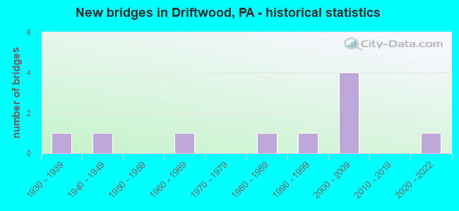
- New bridges - historical statistics
- 11930-1939
- 11940-1949
- 11960-1969
- 11980-1989
- 11990-1999
- 42000-2009
- 12020-2022

- Reconstructed bridges - Historical Statistics
- 12000-2009
- 12010-2019


- Bridge Condition - Deck
- 37.5%Very good
- 37.5%Good
- 25.0%Fair

- Bridge Condition - Superstructure
- 12.5%Excellent
- 12.5%Very good
- 37.5%Good
- 25.0%Satisfactory
- 12.5%Poor

- Bridge Condition - Substructure
- 50.0%Good
- 25.0%Satisfactory
- 12.5%Fair
- 12.5%Poor

- Bridge Condition - Channel
- 30.0%Very good
- 40.0%Good
- 10.0%Satisfactory
- 10.0%Fair
- 10.0%Poor
Find on map >> Show street view
Structure Number: 8865, Location: SINNEMAHONING (Lat: 41.319633, Lng: -78.080703), Route carried "on" structure: State highway 120, Year Built: 1947, Year Reconstructed: 2015, Status: Open, Structure Length: 8.99m (29.49ft), Average Daily Traffic: 292 (year 2020), Truck Traffic: 36%, Average Future Daily Traffic: 549 (year 2040), Design Load: HS 20, Features Intersected: FIRST FORK SINNEMAHONING
Minimum Vertical Clearance: 30+ m (98+ ft), Kilometerpoint: 52.061, Lanes on structure: 2, Base Highway Network: Yes, Owner: State Highway Agency, Approaching Roadway Width: 7.6m (24.9ft), Material/Design: Steel continuous, Design/Construction: Stringer/Multi-beam, Number Of Spans In Main Unit: 4, Length of Maximum Span: 24.7m (81.0ft), Curb-To-Curb Width: 8.4m (27.6ft), Out-to-Out Width: 9.3m (30.5ft)
Condition: Deck: Very good, Superstructure: Satisfactory, Substructure: Satisfactory, Channel: Fair, Operating Rating: 91.6 metric tons, Method Used To Determine Operating Rating: Load Factor (LF), Inventory Rating: 55.3 metric tons, Method Used To Determine Inventory Rating: Load Factor (LF), Structural Evaluation: Equal to present minimum criteria, Deck Geometry: Somewhat better than minimum adequacy, Waterway Adequacy: Equal to present desirable criteria, Approach Roadway Alignment: Better than present minimum criteria, Length Of Structure Improvement: 10.00m (32.81ft), Designated Inspection Frequency: Every 24 months, Inspection Date: May 2020, Bridge Improvement Cost: $77,000, Roadway Improvement Cost: $234,000, Total Project Cost: $1,034,000, Deck Structure Type: Concrete Cast-file-Place, Wearing Surface/Protective System: Wearing Surface: Epoxy Overlay, Deck Protection: Epoxy Coated Reinforcing
Find on map >> Show street view
Structure Number: 892, Location: SINNEMAHONING (Lat: 41.319069, Lng: -78.083772), Route carried "on" structure: State highway , Year Built: 1938, Year Reconstructed: 2009, Status: Open, Structure Length: 12.65m (41.50ft), Average Daily Traffic: 348 (year 2020), Truck Traffic: 3%, Average Future Daily Traffic: 468 (year 2041), Design Load: H 20, Features Intersected: SINNEMAHONING CREEK, Facility Carried by Structure: SR 2001
Minimum Vertical Clearance: 4.72m (15.49ft), Kilometerpoint: 15.821, Lanes on structure: 2, Owner: State Highway Agency, Approaching Roadway Width: 5.5m (18.0ft), Material/Design: Steel, Design/Construction: Truss - Thru, Number Of Spans In Main Unit: 2, Length of Maximum Span: 62.8m (206.0ft), Curb or Sidewalk Widths: Left: 0.1m (0.3ft), Right: 0.1m (0.3ft), Curb-To-Curb Width: 6.1m (20.0ft), Out-to-Out Width: 6.2m (20.3ft)
Condition: Deck: Fair, Superstructure: Satisfactory, Substructure: Fair, Channel: Poor, Operating Rating: 58.1 metric tons, Method Used To Determine Operating Rating: Load Factor (LF), Inventory Rating: 34.5 metric tons, Method Used To Determine Inventory Rating: Load Factor (LF), Structural Evaluation: Somewhat better than minimum adequacy, Deck Geometry: Meets minimum limits, Waterway Adequacy: Somewhat better than minimum adequacy, Approach Roadway Alignment: Equal to present minimum criteria, Length Of Structure Improvement: 12.60m (41.34ft), Designated Inspection Frequency: Every 24 months, Critical Feature Inspection Frequency: Every 24 months, Underwater Inspection Frequency: Every 24 months, Other Special Inspection Frequency: Every 12 months, Inspection Date: March 2020, Critical Feature Inspection Date: June 2020, Underwater Inspection Date: April 2020, Other Special Inspection Date: March 2021, Bridge Improvement Cost: $63,000, Roadway Improvement Cost: $250,000, Total Project Cost: $851,000, Deck Structure Type: Open Grating
Find on map >> Show street view
Structure Number: 8951, Location: 1000FT EAST OF SR 2001 IN (Lat: 41.312611, Lng: -78.079586), Route carried "on" structure: ServiceCity street , Year Built: 1985, Status: Posted for load, Structure Length: 2.01m (6.59ft), Average Daily Traffic: 60 (year 2018), Average Future Daily Traffic: 93 (year 2038), Design Load: HS 20, Features Intersected: WYKOFF RUN, Facility Carried by Structure: T-356 WAS T-355
Minimum Vertical Clearance: 30+ m (98+ ft), Kilometerpoint: 0.000, Lanes on structure: 1, Owner: Town or Township Highway Agency, Approaching Roadway Width: 4.0m (13.1ft), Material/Design: Steel, Design/Construction: Stringer/Multi-beam, Number Of Spans In Main Unit: 1, Length of Maximum Span: 19.8m (65.0ft), Curb-To-Curb Width: 4.1m (13.5ft), Out-to-Out Width: 4.5m (14.8ft)
Condition: Deck: Fair, Superstructure: Poor, Substructure: Poor, Channel: Good, Operating Rating: 24.5 metric tons, Method Used To Determine Operating Rating: Load Factor (LF), Inventory Rating: 14.5 metric tons, Method Used To Determine Inventory Rating: Load Factor (LF), Structural Evaluation: Meets minimum limits, Deck Geometry: Somewhat better than minimum adequacy, Waterway Adequacy: Better than present minimum criteria, Approach Roadway Alignment: Equal to present desirable criteria, Bridge Posting: Required (Relationship of Operating Rating to Maximum Legal Load: 30.0 - 39.9% below), Length Of Structure Improvement: 2.70m (8.86ft), Designated Inspection Frequency: Every 24 months, Other Special Inspection Frequency: Every 12 months, Inspection Date: October 2021, Other Special Inspection Date: October 2021, Deck Structure Type: Wood or Timber, Wearing Surface/Protective System: Wearing Surface: Bituminous
Find on map >> Show street view
Structure Number: 8953, Location: 3.0 MILES SE OF SR 2001 (Lat: 41.295297, Lng: -78.084900), Route carried "on" structure: ServiceCity street , Year Built: 1965, Year Reconstructed: 2021, Status: Open, Structure Length: 1.52m (4.99ft), Average Daily Traffic: 20 (year 2017), Average Future Daily Traffic: 30 (year 2037), Design Load: HS 20, Features Intersected: UPPER JERRY RUN, Facility Carried by Structure: T-356
Minimum Vertical Clearance: 30+ m (98+ ft), Kilometerpoint: 0.000, Lanes on structure: 1, Owner: Town or Township Highway Agency, Approaching Roadway Width: 3.0m (9.8ft), Skew: 1 degrees, Material/Design: Steel, Design/Construction: Stringer/Multi-beam, Number Of Spans In Main Unit: 1, Length of Maximum Span: 15.2m (49.9ft), Curb-To-Curb Width: 3.7m (12.1ft), Out-to-Out Width: 4.0m (13.1ft)
Condition: Deck: Very good, Superstructure: Excellent, Substructure: Satisfactory, Channel: Good, Operating Rating: 39.0 metric tons, Method Used To Determine Operating Rating: Allowable Stress (AS), Inventory Rating: 29.9 metric tons, Method Used To Determine Inventory Rating: Allowable Stress (AS), Structural Evaluation: Equal to present minimum criteria, Deck Geometry: Meets minimum limits, Waterway Adequacy: Better than present minimum criteria, Approach Roadway Alignment: Equal to present desirable criteria, Length Of Structure Improvement: 1.10m (3.61ft), Designated Inspection Frequency: Every 24 months, Inspection Date: October 2021, Deck Structure Type: Wood or Timber
Find on map >> Show street view
Structure Number: 8965, Location: 700' SW OF BENNETS CRK RD (Lat: 41.336397, Lng: -78.197997), Route carried "on" structure: ServiceState lands road , Year Built: 2001, Status: Open, Structure Length: 1.80m (5.91ft), Average Daily Traffic: 60 (year 2012), Average Future Daily Traffic: 75 (year 2032), Design Load: HS 25 or greater, Features Intersected: MIX RUN, Facility Carried by Structure: RED RUN ROAD
Minimum Vertical Clearance: 30+ m (98+ ft), Kilometerpoint: 0.000, Lanes on structure: 2, Owner: State Park, Forest, or Reservation Agency, Approaching Roadway Width: 6.7m (22.0ft), Material/Design: Prestressed concrete, Design/Construction: Box Beam or Girders - Multiple, Number Of Spans In Main Unit: 1, Length of Maximum Span: 17.4m (57.1ft), Curb-To-Curb Width: 6.6m (21.7ft), Out-to-Out Width: 7.6m (24.9ft)
Condition: Deck: Very good, Superstructure: Good, Substructure: Good, Channel: Good, Operating Rating: 88.9 metric tons, Method Used To Determine Operating Rating: Load Factor (LF), Inventory Rating: 40.8 metric tons, Method Used To Determine Inventory Rating: Load Factor (LF), Structural Evaluation: Better than present minimum criteria, Deck Geometry: Somewhat better than minimum adequacy, Waterway Adequacy: Better than present minimum criteria, Approach Roadway Alignment: Better than present minimum criteria, Length Of Structure Improvement: 1.80m (5.91ft), Designated Inspection Frequency: Every 24 months, Inspection Date: August 2020, Deck Structure Type: Concrete Cast-file-Place, Wearing Surface/Protective System: Wearing Surface: Monolithic Concrete, Deck Protection: Epoxy Coated Reinforcing
Find on map >> Show street view
Structure Number: 8966, Location: 2 MI SW BENNETS CRK RD (Lat: 41.317997, Lng: -78.209297), Route carried "on" structure: ServiceState lands road , Year Built: 2001, Status: Open, Structure Length: 1.80m (5.91ft), Average Daily Traffic: 60 (year 2012), Average Future Daily Traffic: 75 (year 2032), Design Load: HS 25 or greater, Features Intersected: MIX RUN, Facility Carried by Structure: RED RUN ROAD
Minimum Vertical Clearance: 30+ m (98+ ft), Kilometerpoint: 0.000, Lanes on structure: 2, Owner: State Park, Forest, or Reservation Agency, Approaching Roadway Width: 6.4m (21.0ft), Material/Design: Prestressed concrete, Design/Construction: Box Beam or Girders - Multiple, Number Of Spans In Main Unit: 1, Length of Maximum Span: 17.4m (57.1ft), Curb-To-Curb Width: 6.6m (21.7ft), Out-to-Out Width: 7.6m (24.9ft)
Condition: Deck: Good, Superstructure: Good, Substructure: Good, Channel: Satisfactory, Operating Rating: 93.4 metric tons, Method Used To Determine Operating Rating: Load Factor (LF), Inventory Rating: 44.5 metric tons, Method Used To Determine Inventory Rating: Load Factor (LF), Structural Evaluation: Better than present minimum criteria, Deck Geometry: Somewhat better than minimum adequacy, Waterway Adequacy: Superior to present desirable criteria, Approach Roadway Alignment: Better than present minimum criteria, Length Of Structure Improvement: 1.80m (5.91ft), Designated Inspection Frequency: Every 24 months, Inspection Date: August 2020, Deck Structure Type: Concrete Cast-file-Place, Wearing Surface/Protective System: Wearing Surface: Monolithic Concrete, Deck Protection: Epoxy Coated Reinforcing
Find on map >> Show street view
Structure Number: 40576, Location: 0.5 MILES E OF SR 555 INT (Lat: 41.334347, Lng: -78.135111), Route carried "on" structure: City street , Year Built: 1999, Status: Open, Structure Length: 12.50m (41.01ft), Average Daily Traffic: 250 (year 2021), Truck Traffic: 1%, Average Future Daily Traffic: 350 (year 2041), Design Load: HS 25 or greater, Features Intersected: BENNETT BR.SINNEMAHONING, Facility Carried by Structure: Karthaus Mtn Road
Minimum Vertical Clearance: 30+ m (98+ ft), Kilometerpoint: 0.000, Lanes on structure: 2, Owner: County Highway Agency, Approaching Roadway Width: 8.5m (27.9ft), Skew: 5 degrees, Material/Design: Prestressed concrete, Design/Construction: Stringer/Multi-beam, Number Of Spans In Main Unit: 4, Length of Maximum Span: 29.9m (98.1ft), Curb or Sidewalk Widths: Left: 0.2m (0.7ft), Right: 0.2m (0.7ft), Curb-To-Curb Width: 8.5m (27.9ft), Out-to-Out Width: 9.4m (30.8ft)
Condition: Deck: Good, Superstructure: Good, Substructure: Good, Channel: Very good, Operating Rating: 96.2 metric tons, Method Used To Determine Operating Rating: Load Factor (LF), Inventory Rating: 47.2 metric tons, Method Used To Determine Inventory Rating: Load Factor (LF), Structural Evaluation: Better than present minimum criteria, Deck Geometry: Equal to present minimum criteria, Waterway Adequacy: Equal to present desirable criteria, Approach Roadway Alignment: Better than present minimum criteria, Length Of Structure Improvement: 13.40m (43.96ft), Designated Inspection Frequency: Every 24 months, Inspection Date: July 2021, Deck Structure Type: Concrete Cast-file-Place, Wearing Surface/Protective System: Wearing Surface: Monolithic Concrete, Deck Protection: Epoxy Coated Reinforcing
Find on map >> Show street view
Structure Number: 45105, Location: 4 MI SW SINNEMAHONING (Lat: 41.278883, Lng: -78.140083), Route carried "on" structure: State highway , Year Built: 2008, Status: Open, Structure Length: 0.73m (2.40ft), Average Daily Traffic: 348 (year 2020), Truck Traffic: 3%, Average Future Daily Traffic: 468 (year 2040), Design Load: HL 93, Features Intersected: LAUREL RUN, Facility Carried by Structure: SR 2001
Minimum Vertical Clearance: 30+ m (98+ ft), Kilometerpoint: 8.966, Lanes on structure: 2, Owner: State Highway Agency, Approaching Roadway Width: 6.1m (20.0ft), Skew: 4 degrees, Material/Design: Concrete, Design/Construction: Culvert, Number Of Spans In Main Unit: 1, Length of Maximum Span: 7.3m (24.0ft)
Condition: Channel: Very good, Culverts: Very good, Operating Rating: 79.8 metric tons, Method Used To Determine Operating Rating: Load Factor (LF), Inventory Rating: 48.1 metric tons, Method Used To Determine Inventory Rating: Load Factor (LF), Structural Evaluation: Equal to present desirable criteria, Waterway Adequacy: Equal to present desirable criteria, Approach Roadway Alignment: Equal to present desirable criteria, Designated Inspection Frequency: Every 24 months, Inspection Date: May 2020
Find on map >> Show street view
Structure Number: 45264, Location: DRIFTWOOD BORO (Lat: 41.337592, Lng: -78.135075), Route carried "on" structure: State highway 555, Year Built: 2009, Status: Open, Structure Length: 8.47m (27.79ft), Average Daily Traffic: 709 (year 2022), Truck Traffic: 2%, Average Future Daily Traffic: 481 (year 2040), Design Load: HL 93, Features Intersected: DRIFTWOOD BRANCH
Minimum Vertical Clearance: 30+ m (98+ ft), Kilometerpoint: 13.012, Lanes on structure: 2, Owner: State Highway Agency, Approaching Roadway Width: 10.7m (35.1ft), Skew: 1 degrees, Material/Design: Prestressed concrete continuous, Design/Construction: Box Beam or Girders - Single/Spread, Number Of Spans In Main Unit: 3, Length of Maximum Span: 28.3m (92.8ft), Curb or Sidewalk Widths: Left: 0.5m (1.6ft), Right: 0.5m (1.6ft), Curb-To-Curb Width: 10.7m (35.1ft), Out-to-Out Width: 11.7m (38.4ft)
Condition: Deck: Good, Superstructure: Very good, Substructure: Good, Channel: Very good, Operating Rating: 67.1 metric tons, Method Used To Determine Operating Rating: Load Factor (LF), Inventory Rating: 33.6 metric tons, Method Used To Determine Inventory Rating: Load Factor (LF), Structural Evaluation: Better than present minimum criteria, Deck Geometry: Equal to present minimum criteria, Waterway Adequacy: Equal to present desirable criteria, Approach Roadway Alignment: Better than present minimum criteria, Designated Inspection Frequency: Every 24 months, Inspection Date: May 2020, Deck Structure Type: Concrete Cast-file-Place, Wearing Surface/Protective System: Wearing Surface: Monolithic Concrete, Deck Protection: Epoxy Coated Reinforcing
Find on map >> Show street view
Structure Number: 68544, Location: SINNEMAHONING (Lat: 41.318619, Lng: -78.097583), Route carried "on" structure: State highway 120, Year Built: 2021, Status: Open, Structure Length: 0.73m (2.40ft), Average Daily Traffic: 648 (year 2020), Truck Traffic: 19%, Average Future Daily Traffic: 859 (year 2041), Design Load: HL 93, Features Intersected: GROVE RUN
Minimum Vertical Clearance: 30+ m (98+ ft), Kilometerpoint: 49.629, Lanes on structure: 2, Base Highway Network: Yes, Owner: State Highway Agency, Approaching Roadway Width: 6.1m (20.0ft), Material/Design: Concrete, Design/Construction: Culvert, Number Of Spans In Main Unit: 1, Length of Maximum Span: 7.3m (24.0ft), Curb-To-Curb Width: 7.3m (24.0ft), Out-to-Out Width: 8.4m (27.6ft)
Condition: Channel: Good, Culverts: Very good, Operating Rating: 50.9 metric tons, Method Used To Determine Operating Rating: Assigned ratings based on Load and Resistance Factor Design (LRFD) reported by rating factor (RF) using HL93 loadings, Inventory Rating: 39.2 metric tons, Method Used To Determine Inventory Rating: Assigned ratings based on Load and Resistance Factor Design (LRFD) reported by rating factor (RF) using HL93 loadings, Structural Evaluation: Equal to present desirable criteria, Deck Geometry: Meets minimum limits, Waterway Adequacy: Better than present minimum criteria, Approach Roadway Alignment: Equal to present desirable criteria, Designated Inspection Frequency: Every 24 months, Inspection Date: November 2021