Bridge Statistics for Dry Tavern, Pennsylvania (PA)
Condition, Traffic, Stress, Structural Evaluation, Project Costs
- National Bridge Inventory (NBI) Statistics
- 31Number of bridges
- 420ft / 128mTotal length
- $12,780,000Total costs
- 240,323Total average daily traffic
- 16,171Total average daily truck traffic
- 234,474Total future (year 2009) average daily traffic
- National Bridge Inventory (NBI) Registered Bridges for Dry Tavern
- No street view available for this location
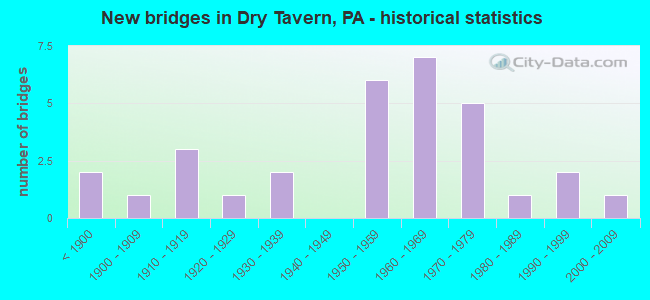
- New bridges - historical statistics
- 2Before 1900
- 11900-1909
- 31910-1919
- 11920-1929
- 21930-1939
- 61950-1959
- 71960-1969
- 51970-1979
- 11980-1989
- 21990-1999
- 12000-2009

- Reconstructed bridges - Historical Statistics
- 21920-1929
- 01930-1939
- 01940-1949
- 11950-1959
- 01960-1969
- 11970-1979
- 21980-1989
- 01990-1999
- 52000-2009
- 22010-2019


- Bridge Condition - Deck
- 3.8%Very good
- 23.1%Good
- 34.6%Satisfactory
- 26.9%Fair
- 11.5%Poor

- Bridge Condition - Superstructure
- 14.3%Good
- 35.7%Satisfactory
- 28.6%Fair
- 17.9%Poor
- 3.6%Serious

- Bridge Condition - Substructure
- 25.0%Good
- 35.7%Satisfactory
- 25.0%Fair
- 14.3%Poor

- Bridge Condition - Channel
- 3.8%Very good
- 15.4%Good
- 19.2%Satisfactory
- 42.3%Fair
- 19.2%Poor

- Bridge Condition - Culverts
- 33.3%Very good
- 66.7%Satisfactory
Find on map >> Show street view
Structure Number: 164, Location: W. OF HUNTERSTOWN (Lat: 39.889514, Lng: -77.181711), Route carried "on" structure: State highway 394, Year Built: 1963, Year Reconstructed: 2011, Status: Open, Structure Length: 4.02m (13.19ft), Average Daily Traffic: 3,054 (year 2020), Truck Traffic: 9%, Average Future Daily Traffic: 4,436 (year 2032), Design Load: HS 20, Features Intersected: US 15; SR 0015
Minimum Vertical Clearance: 30+ m (98+ ft), Kilometerpoint: 7.749, Lanes on structure: 2, Lanes under structure: 8, Owner: State Highway Agency, Approaching Roadway Width: 11.6m (38.1ft), Material/Design: Prestressed concrete, Design/Construction: Stringer/Multi-beam, Number Of Spans In Main Unit: 2, Length of Maximum Span: 19.8m (65.0ft), Curb or Sidewalk Widths: Left: 0.2m (0.7ft), Right: 0.2m (0.7ft), Curb-To-Curb Width: 11.1m (36.4ft), Out-to-Out Width: 12.2m (40.0ft)
Condition: Deck: Good, Superstructure: Good, Substructure: Satisfactory, Operating Rating: 83.5 metric tons, Method Used To Determine Operating Rating: Load Factor (LF), Inventory Rating: 16.3 metric tons, Method Used To Determine Inventory Rating: Load Factor (LF), Structural Evaluation: Meets minimum limits, Deck Geometry: Somewhat better than minimum adequacy, Underclear: Equal to present minimum criteria, Approach Roadway Alignment: Equal to present desirable criteria, Length Of Structure Improvement: 4.00m (13.12ft), Designated Inspection Frequency: Every 24 months, Inspection Date: May 2021, Bridge Improvement Cost: $23,000, Roadway Improvement Cost: $67,000, Total Project Cost: $307,000, Deck Structure Type: Concrete Cast-file-Place, Wearing Surface/Protective System: Wearing Surface: Monolithic Concrete, Deck Protection: Epoxy Coated Reinforcing
Find on map >> Show street view
Structure Number: 388, Location: 2 SE ARENDTSVILLE/CONEWAG (Lat: 39.902600, Lng: -77.265900), Route carried "on" structure: City street , Year Built: 1974, Status: Open, Structure Length: 2.59m (8.50ft), Average Daily Traffic: 300 (year 2009), Truck Traffic: 2%, Average Future Daily Traffic: 420 (year 2030), Design Load: HS 20+Mod, Features Intersected: CONEWAGO CREEK, Facility Carried by Structure: RUSSELL TAVERN RD
Minimum Vertical Clearance: 30+ m (98+ ft), Kilometerpoint: 0.000, Lanes on structure: 2, Owner: County Highway Agency, Approaching Roadway Width: 6.4m (21.0ft), Material/Design: Prestressed concrete, Design/Construction: Box Beam or Girders - Multiple, Number Of Spans In Main Unit: 1, Length of Maximum Span: 25.6m (84.0ft), Curb or Sidewalk Widths: Left: 0.2m (0.7ft), Right: 0.2m (0.7ft), Curb-To-Curb Width: 9.1m (29.9ft), Out-to-Out Width: 10.2m (33.5ft)
Condition: Deck: Fair, Superstructure: Fair, Substructure: Good, Channel: Fair, Operating Rating: 44.5 metric tons, Method Used To Determine Operating Rating: Load Factor (LF), Inventory Rating: 12.7 metric tons, Method Used To Determine Inventory Rating: Load Factor (LF), Structural Evaluation: Meets minimum limits, Deck Geometry: Equal to present minimum criteria, Waterway Adequacy: Equal to present desirable criteria, Approach Roadway Alignment: Equal to present desirable criteria, Length Of Structure Improvement: 2.60m (8.53ft), Designated Inspection Frequency: Every 24 months, Inspection Date: July 2021, Deck Structure Type: Other, Wearing Surface/Protective System: Wearing Surface: Bituminous, Membrane: Preformed Fabric
Find on map >> Show street view
Structure Number: 395, Location: 1.5 SE BENDRSVILL/OPOSSUM (Lat: 39.964758, Lng: -77.221694), Route carried "on" structure: City street , Year Built: 1956, Status: Open, Structure Length: 1.77m (5.81ft), Average Daily Traffic: 100 (year 2009), Truck Traffic: 3%, Average Future Daily Traffic: 140 (year 2030), Design Load: HS 20, Features Intersected: OPOSSUM CREEK, Facility Carried by Structure: ORCHARD ROAD
Minimum Vertical Clearance: 30+ m (98+ ft), Kilometerpoint: 0.000, Lanes on structure: 1, Owner: County Highway Agency, Approaching Roadway Width: 6.7m (22.0ft), Material/Design: Prestressed concrete, Design/Construction: Box Beam or Girders - Multiple, Number Of Spans In Main Unit: 1, Length of Maximum Span: 17.1m (56.1ft), Curb or Sidewalk Widths: Left: 0.2m (0.7ft), Right: 0.2m (0.7ft), Curb-To-Curb Width: 5.1m (16.7ft), Out-to-Out Width: 5.5m (18.0ft)
Condition: Deck: Fair, Superstructure: Fair, Substructure: Fair, Channel: Fair, Operating Rating: 46.3 metric tons, Method Used To Determine Operating Rating: Load Factor (LF), Inventory Rating: 23.6 metric tons, Method Used To Determine Inventory Rating: Load Factor (LF), Structural Evaluation: Somewhat better than minimum adequacy, Deck Geometry: High priority of corrective action, Waterway Adequacy: Better than present minimum criteria, Approach Roadway Alignment: Equal to present desirable criteria, Length Of Structure Improvement: 2.50m (8.20ft), Designated Inspection Frequency: Every 24 months, Inspection Date: July 2021, Bridge Improvement Cost: $7,000, Roadway Improvement Cost: $20,000, Total Project Cost: $92,000, Deck Structure Type: Other, Wearing Surface/Protective System: Wearing Surface: Bituminous
Find on map >> Show street view
Structure Number: 407, Location: 1.5 SE ROUND TOP/ROCK CRE (Lat: 39.782553, Lng: -77.206433), Route carried "on" structure: City street , Year Built: 1936, Status: Posted for load, Structure Length: 2.68m (8.79ft), Average Daily Traffic: 125 (year 2009), Truck Traffic: 2%, Average Future Daily Traffic: 175 (year 2030), Design Load: H 20, Features Intersected: ROCK CREEK, Facility Carried by Structure: GOULDEN ROAD
Minimum Vertical Clearance: 30+ m (98+ ft), Kilometerpoint: 0.000, Lanes on structure: 2, Owner: County Highway Agency, Approaching Roadway Width: 6.1m (20.0ft), Material/Design: Steel continuous, Design/Construction: Stringer/Multi-beam, Number Of Spans In Main Unit: 2, Length of Maximum Span: 12.8m (42.0ft), Curb or Sidewalk Widths: Left: 0.2m (0.7ft), Right: 0.2m (0.7ft), Curb-To-Curb Width: 6.0m (19.7ft), Out-to-Out Width: 7.0m (23.0ft)
Condition: Deck: Fair, Superstructure: Poor, Substructure: Fair, Channel: Good, Operating Rating: 34.5 metric tons, Method Used To Determine Operating Rating: Load Factor (LF), Inventory Rating: 20.9 metric tons, Method Used To Determine Inventory Rating: Load Factor (LF), Structural Evaluation: Meets minimum limits, Deck Geometry: High priority of corrective action, Waterway Adequacy: Equal to present desirable criteria, Approach Roadway Alignment: Somewhat better than minimum adequacy, Bridge Posting: Required (Relationship of Operating Rating to Maximum Legal Load: 10.0 - 19.9% below), Length Of Structure Improvement: 2.70m (8.86ft), Designated Inspection Frequency: Every 24 months, Other Special Inspection Frequency: Every 12 months, Inspection Date: May 2021, Other Special Inspection Date: May 2021, Deck Structure Type: Concrete Cast-file-Place, Wearing Surface/Protective System: Wearing Surface: Bituminous
Find on map >> Show street view
Structure Number: 408, Location: 2.5 N.GETTSBRG/ROCK CREEK (Lat: 39.867225, Lng: -77.222786), Route carried "on" structure: City street , Year Built: 1963, Status: Open, Structure Length: 1.43m (4.69ft), Average Daily Traffic: 100 (year 2009), Truck Traffic: 5%, Average Future Daily Traffic: 140 (year 2030), Design Load: HS 20, Features Intersected: ROCK CREEK, Facility Carried by Structure: GOOD INTENT ROAD
Minimum Vertical Clearance: 30+ m (98+ ft), Kilometerpoint: 0.000, Lanes on structure: 2, Owner: County Highway Agency, Approaching Roadway Width: 7.0m (23.0ft), Material/Design: Prestressed concrete, Design/Construction: Box Beam or Girders - Multiple, Number Of Spans In Main Unit: 1, Length of Maximum Span: 14.0m (45.9ft), Curb or Sidewalk Widths: Left: 0.5m (1.6ft), Right: 0.5m (1.6ft), Curb-To-Curb Width: 8.5m (27.9ft), Out-to-Out Width: 10.2m (33.5ft)
Condition: Deck: Satisfactory, Superstructure: Satisfactory, Substructure: Good, Channel: Satisfactory, Operating Rating: 69.9 metric tons, Method Used To Determine Operating Rating: Load and Resistance Factor (LRFR), Inventory Rating: 30.8 metric tons, Method Used To Determine Inventory Rating: Load and Resistance Factor (LRFR), Structural Evaluation: Equal to present minimum criteria, Deck Geometry: Better than present minimum criteria, Waterway Adequacy: Better than present minimum criteria, Approach Roadway Alignment: Equal to present desirable criteria, Length Of Structure Improvement: 1.40m (4.59ft), Designated Inspection Frequency: Every 24 months, Inspection Date: July 2021, Deck Structure Type: Other, Wearing Surface/Protective System: Wearing Surface: Bituminous, Membrane: Preformed Fabric
Find on map >> Show street view
Structure Number: 46, Location: 1.5 GULDENS TR.SWIFT RUN (Lat: 39.846358, Lng: -77.124156), Route carried "on" structure: City street , Year Built: 1950, Status: Open, Structure Length: 0.73m (2.40ft), Average Daily Traffic: 50 (year 2009), Truck Traffic: 5%, Average Future Daily Traffic: 70 (year 2030), Features Intersected: TRIB OF SWIFT RUN, Facility Carried by Structure: SALEM CHURCH RD
Minimum Vertical Clearance: 30+ m (98+ ft), Kilometerpoint: 0.000, Lanes on structure: 2, Owner: Town or Township Highway Agency, Approaching Roadway Width: 5.5m (18.0ft), Material/Design: Masonry, Design/Construction: Arch - Deck, Number Of Spans In Main Unit: 2, Length of Maximum Span: 3.0m (9.8ft), Curb or Sidewalk Widths: Left: 0.0m, Right: 0.2m (0.7ft), Curb-To-Curb Width: 6.9m (22.6ft), Out-to-Out Width: 7.8m (25.6ft)
Condition: Superstructure: Satisfactory, Substructure: Satisfactory, Channel: Fair, Operating Rating: 49.0 metric tons, Method Used To Determine Operating Rating: Field evaluation and documented engineering judgment, Inventory Rating: 32.7 metric tons, Method Used To Determine Inventory Rating: Field evaluation and documented engineering judgment, Structural Evaluation: Equal to present minimum criteria, Deck Geometry: Somewhat better than minimum adequacy, Waterway Adequacy: Equal to present minimum criteria, Approach Roadway Alignment: Equal to present desirable criteria, Length Of Structure Improvement: 1.60m (5.25ft), Designated Inspection Frequency: Every 24 months, Inspection Date: April 2021
Find on map >> Show street view
Structure Number: 691, Location: SOUTH END BRIDGE (Lat: 40.355228, Lng: -80.114289), Route carried "on" structure: State highway 50, Year Built: 1985, Status: Open, Structure Length: 4.05m (13.29ft), Average Daily Traffic: 22,127 (year 2020), Truck Traffic: 4%, Average Future Daily Traffic: 25,464 (year 2032), Design Load: HS 20, Features Intersected: CHARTIERS CREEK, Facility Carried by Structure: WASHINGTON AV
Minimum Vertical Clearance: 30+ m (98+ ft), Kilometerpoint: 7.123, Lanes on structure: 4, Base Highway Network: Yes, Owner: State Highway Agency, Approaching Roadway Width: 14.6m (47.9ft), Material/Design: Prestressed concrete, Design/Construction: Box Beam or Girders - Multiple, Number Of Spans In Main Unit: 1, Length of Maximum Span: 38.7m (127.0ft), Curb or Sidewalk Widths: Left: 0.2m (0.7ft), Right: 1.5m (4.9ft), Curb-To-Curb Width: 14.6m (47.9ft), Out-to-Out Width: 17.7m (58.1ft)
Condition: Deck: Fair, Superstructure: Poor, Substructure: Fair, Channel: Good, Inventory Rating: 25.4 metric tons, Method Used To Determine Inventory Rating: Load Factor (LF), Structural Evaluation: Meets minimum limits, Deck Geometry: High priority of replacement, Waterway Adequacy: Better than present minimum criteria, Approach Roadway Alignment: Equal to present desirable criteria, Length Of Structure Improvement: 4.10m (13.45ft), Designated Inspection Frequency: Every 24 months, Inspection Date: October 2020, Bridge Improvement Cost: $52,000, Roadway Improvement Cost: $153,000, Total Project Cost: $701,000, Deck Structure Type: Concrete Cast-file-Place, Wearing Surface/Protective System: Wearing Surface: Monolithic Concrete, Deck Protection: Epoxy Coated Reinforcing
Find on map >> Show street view
Structure Number: 751, Location: PGH-MCKEES ROCKS LINE (Lat: 40.463731, Lng: -80.057208), Route carried "on" structure: State highway 51, Year Built: 1966, Year Reconstructed: 1989, Status: Open, Structure Length: 5.94m (19.49ft), Average Daily Traffic: 9,604 (year 2022), Truck Traffic: 4%, Average Future Daily Traffic: 15,696 (year 2032), Design Load: HS 20, Features Intersected: CHARTIERS CREEK, Facility Carried by Structure: CHARTIERS AV
Minimum Vertical Clearance: 30+ m (98+ ft), Kilometerpoint: 36.178, Lanes on structure: 4, Base Highway Network: Yes, Owner: State Highway Agency, Approaching Roadway Width: 21.3m (69.9ft), Skew: 1 degrees, Material/Design: Prestressed concrete, Design/Construction: Box Beam or Girders - Single/Spread, Number Of Spans In Main Unit: 2, Length of Maximum Span: 28.3m (92.8ft), Curb or Sidewalk Widths: Left: 1.5m (4.9ft), Right: 1.5m (4.9ft), Curb-To-Curb Width: 18.3m (60.0ft), Out-to-Out Width: 22.1m (72.5ft)
Condition: Deck: Satisfactory, Superstructure: Good, Substructure: Satisfactory, Channel: Satisfactory, Operating Rating: 87.1 metric tons, Method Used To Determine Operating Rating: Load Factor (LF), Inventory Rating: 3.6 metric tons, Method Used To Determine Inventory Rating: Load Factor (LF), Structural Evaluation: High priority of corrective action, Deck Geometry: Somewhat better than minimum adequacy, Waterway Adequacy: Superior to present desirable criteria, Approach Roadway Alignment: Meets minimum limits, Length Of Structure Improvement: 5.90m (19.36ft), Designated Inspection Frequency: Every 24 months, Underwater Inspection Frequency: Every 60 months, Inspection Date: May 2021, Underwater Inspection Date: June 2019, Bridge Improvement Cost: $25,000, Roadway Improvement Cost: $100,000, Total Project Cost: $332,000, Deck Structure Type: Concrete Cast-file-Place, Wearing Surface/Protective System: Wearing Surface: Monolithic Concrete, Deck Protection: Epoxy Coated Reinforcing
Find on map >> Show street view
Structure Number: 754, Location: GROVETON INTER 79 & 51 (Lat: 40.503644, Lng: -80.136289), Route carried "on" structure: State highway 51, Year Built: 1973, Status: Open, Structure Length: 0.91m (2.99ft), Average Daily Traffic: 8,210 (year 2020), Truck Traffic: 5%, Average Future Daily Traffic: 13,330 (year 2032), Design Load: HS 20, Features Intersected: MONTOUR RUN, Facility Carried by Structure: CORAOPOLIS BLVD
Minimum Vertical Clearance: 30+ m (98+ ft), Kilometerpoint: 46.420, Lanes on structure: 4, Base Highway Network: Yes, Owner: State Highway Agency, Approaching Roadway Width: 28.0m (91.9ft), Skew: 20 degrees, Material/Design: Concrete, Design/Construction: Culvert, Number Of Spans In Main Unit: 1, Length of Maximum Span: 9.1m (29.9ft)
Condition: Channel: Satisfactory, Culverts: Satisfactory, Operating Rating: 49.0 metric tons, Method Used To Determine Operating Rating: Field evaluation and documented engineering judgment, Inventory Rating: 32.7 metric tons, Method Used To Determine Inventory Rating: Field evaluation and documented engineering judgment, Structural Evaluation: Equal to present minimum criteria, Waterway Adequacy: Superior to present desirable criteria, Approach Roadway Alignment: Equal to present desirable criteria, Length Of Structure Improvement: 1.70m (5.58ft), Designated Inspection Frequency: Every 24 months, Inspection Date: December 2019, Bridge Improvement Cost: $70,000, Roadway Improvement Cost: $206,000, Total Project Cost: $943,000
Find on map >> Show street view
Structure Number: 755, Location: OVER TWP.RD.142 (Lat: 40.504892, Lng: -80.144653), Route carried "on" structure: State highway 51, Year Built: 1929, Year Reconstructed: 1982, Status: Open, Structure Length: 12.04m (39.50ft), Average Daily Traffic: 14,401 (year 2022), Truck Traffic: 9%, Average Future Daily Traffic: 15,113 (year 2032), Design Load: HS 20, Features Intersected: TWP 142 & MONTOUR RUN, Facility Carried by Structure: CORAOPOLIS BLVD
Minimum Vertical Clearance: 30+ m (98+ ft), Kilometerpoint: 47.476, Lanes on structure: 2, Lanes under structure: 2, Base Highway Network: Yes, Owner: State Highway Agency, Approaching Roadway Width: 10.1m (33.1ft), Skew: 9 degrees, Material/Design: Steel, Design/Construction: Girder and Floorbeam System, Number Of Spans In Main Unit: 1, Number Of Approach Spans: 6, Length of Maximum Span: 26.8m (87.9ft), Curb or Sidewalk Widths: Left: 1.2m (3.9ft), Right: 0.2m (0.7ft), Curb-To-Curb Width: 8.5m (27.9ft), Out-to-Out Width: 11.1m (36.4ft)
Condition: Deck: Good, Superstructure: Fair, Substructure: Fair, Channel: Fair, Operating Rating: 47.2 metric tons, Method Used To Determine Operating Rating: Load Factor (LF), Inventory Rating: 28.1 metric tons, Method Used To Determine Inventory Rating: Load Factor (LF), Structural Evaluation: Somewhat better than minimum adequacy, Deck Geometry: Meets minimum limits, Underclear: Superior to present desirable criteria, Waterway Adequacy: Superior to present desirable criteria, Approach Roadway Alignment: Equal to present minimum criteria, Length Of Structure Improvement: 12.00m (39.37ft), Designated Inspection Frequency: Every 24 months, Critical Feature Inspection Frequency: Every 24 months, Inspection Date: May 2021, Critical Feature Inspection Date: May 2021, Bridge Improvement Cost: $16,000, Roadway Improvement Cost: $48,000, Total Project Cost: $218,000, Deck Structure Type: Concrete Cast-file-Place, Wearing Surface/Protective System: Wearing Surface: Monolithic Concrete, Deck Protection: Epoxy Coated Reinforcing
Find on map >> Show street view
Structure Number: 117, Location: @ INT W/ S BRADDOCK AVE (Lat: 40.427214, Lng: -79.891189), Route carried "on" structure: Interstate 376, Year Built: 1951, Year Reconstructed: 2007, Status: Open, Structure Length: 5.30m (17.39ft), Average Daily Traffic: 95,540 (year 2022), Truck Traffic: 4%, Average Future Daily Traffic: 60,150 (year 2032), Design Load: HS 20, Features Intersected: SR 8010 RAMP B, Facility Carried by Structure: PARKWAY EAST
Minimum Vertical Clearance: 30+ m (98+ ft), Kilometerpoint: 43.959, Lanes on structure: 5, Lanes under structure: 2, Base Highway Network: Yes, Owner: State Highway Agency, Approaching Roadway Width: 21.9m (71.9ft), Skew: 33 degrees, Material/Design: Steel, Design/Construction: Stringer/Multi-beam, Number Of Spans In Main Unit: 3, Length of Maximum Span: 19.8m (65.0ft), Curb or Sidewalk Widths: Left: 0.2m (0.7ft), Right: 0.2m (0.7ft), Curb-To-Curb Width: 25.0m (82.0ft), Out-to-Out Width: 26.5m (86.9ft)
Condition: Deck: Satisfactory, Superstructure: Satisfactory, Substructure: Satisfactory, Operating Rating: 57.2 metric tons, Method Used To Determine Operating Rating: Load Factor (LF), Inventory Rating: 34.5 metric tons, Method Used To Determine Inventory Rating: Load Factor (LF), Structural Evaluation: Equal to present minimum criteria, Deck Geometry: Better than present minimum criteria, Underclear: High priority of corrective action, Approach Roadway Alignment: Equal to present desirable criteria, Length Of Structure Improvement: 6.30m (20.67ft), Designated Inspection Frequency: Every 24 months, Inspection Date: July 2021, Bridge Improvement Cost: $126,000, Roadway Improvement Cost: $372,000, Total Project Cost: $1,703,000, Deck Structure Type: Concrete Cast-file-Place, Wearing Surface/Protective System: Wearing Surface: Latex Concrete
Find on map >> Show street view
Structure Number: 275, Location: RAMP D OVER RR & CREEK (Lat: 40.400417, Lng: -80.106583), Route carried "on" structure: Ramp State highway , Year Built: 1967, Year Reconstructed: 2006, Status: Open, Structure Length: 20.39m (66.90ft), Average Daily Traffic: 2,624 (year 2021), Truck Traffic: 18%, Average Future Daily Traffic: 3,695 (year 2032), Design Load: HS 20, Features Intersected: P&OC RR & ROBINSON RUN, Facility Carried by Structure: RAMP D
Minimum Vertical Clearance: 30+ m (98+ ft), Kilometerpoint: 0.000, Lanes on structure: 1, Base Highway Network: Yes, Owner: State Highway Agency, Approaching Roadway Width: 7.0m (23.0ft), Material/Design: Steel continuous, Design/Construction: Stringer/Multi-beam, Number Of Spans In Main Unit: 6, Length of Maximum Span: 46.3m (151.9ft), Curb or Sidewalk Widths: Left: 0.2m (0.7ft), Right: 0.2m (0.7ft), Curb-To-Curb Width: 7.0m (23.0ft), Out-to-Out Width: 8.1m (26.6ft)
Condition: Deck: Good, Superstructure: Good, Substructure: Satisfactory, Channel: Good, Operating Rating: 67.1 metric tons, Method Used To Determine Operating Rating: Load Factor (LF), Inventory Rating: 39.9 metric tons, Method Used To Determine Inventory Rating: Load Factor (LF), Structural Evaluation: Equal to present minimum criteria, Deck Geometry: Equal to present minimum criteria, Underclear: High priority of corrective action, Waterway Adequacy: Superior to present desirable criteria, Approach Roadway Alignment: Equal to present desirable criteria, Length Of Structure Improvement: 20.50m (67.26ft), Designated Inspection Frequency: Every 48 months, Inspection Date: October 2019, Bridge Improvement Cost: $226,000, Roadway Improvement Cost: $667,000, Total Project Cost: $3,056,000, Deck Structure Type: Concrete Cast-file-Place, Wearing Surface/Protective System: Wearing Surface: Monolithic Concrete, Deck Protection: Epoxy Coated Reinforcing
Find on map >> Show street view
Structure Number: 302, Location: BRADYS BEND NO.7 (Lat: 40.997861, Lng: -79.620211), Route carried "on" structure: State highway 68, Year Built: 1919, Year Reconstructed: 2008, Status: Open, Structure Length: 1.22m (4.00ft), Average Daily Traffic: 2,871 (year 2020), Truck Traffic: 6%, Average Future Daily Traffic: 3,960 (year 2032), Design Load: HS 20, Features Intersected: SUGAR CREEK
Minimum Vertical Clearance: 30+ m (98+ ft), Kilometerpoint: 7.084, Lanes on structure: 2, Base Highway Network: Yes, Owner: State Highway Agency, Approaching Roadway Width: 8.2m (26.9ft), Skew: 2 degrees, Material/Design: Prestressed concrete, Design/Construction: Box Beam or Girders - Multiple, Number Of Spans In Main Unit: 1, Length of Maximum Span: 11.0m (36.1ft), Curb-To-Curb Width: 9.4m (30.8ft), Out-to-Out Width: 10.2m (33.5ft)
Condition: Deck: Satisfactory, Superstructure: Fair, Substructure: Fair, Channel: Poor, Operating Rating: 81.6 metric tons, Method Used To Determine Operating Rating: Load Factor (LF), Inventory Rating: 43.5 metric tons, Method Used To Determine Inventory Rating: Load Factor (LF), Structural Evaluation: Somewhat better than minimum adequacy, Deck Geometry: Meets minimum limits, Waterway Adequacy: Equal to present desirable criteria, Approach Roadway Alignment: Equal to present minimum criteria, Length Of Structure Improvement: 1.90m (6.23ft), Designated Inspection Frequency: Every 24 months, Inspection Date: December 2020, Bridge Improvement Cost: $12,000, Roadway Improvement Cost: $57,000, Total Project Cost: $163,000, Deck Structure Type: Concrete Cast-file-Place, Wearing Surface/Protective System: Wearing Surface: Monolithic Concrete, Deck Protection: Epoxy Coated Reinforcing
Find on map >> Show street view
Structure Number: 4595, Location: VINCE JAMES BRIDGE (Lat: 40.432258, Lng: -75.938475), Route carried "on" structure: State highway 61, Year Built: 1962, Year Reconstructed: 1993, Status: Open, Structure Length: 13.26m (43.50ft), Average Daily Traffic: 28,651 (year 2021), Truck Traffic: 8%, Average Future Daily Traffic: 35,240 (year 2032), Design Load: HS 20, Features Intersected: MAIDEN CREEK
Minimum Vertical Clearance: 30+ m (98+ ft), Kilometerpoint: 9.382, Lanes on structure: 4, Base Highway Network: Yes, Owner: State Highway Agency, Approaching Roadway Width: 20.7m (67.9ft), Skew: 23 degrees, Material/Design: Prestressed concrete, Design/Construction: Stringer/Multi-beam, Number Of Spans In Main Unit: 5, Length of Maximum Span: 27.4m (89.9ft), Curb or Sidewalk Widths: Left: 0.2m (0.7ft), Right: 0.2m (0.7ft), Curb-To-Curb Width: 18.3m (60.0ft), Out-to-Out Width: 20.0m (65.6ft)
Condition: Deck: Satisfactory, Superstructure: Fair, Substructure: Satisfactory, Channel: Fair, Operating Rating: 45.4 metric tons, Method Used To Determine Operating Rating: Load Factor (LF), Inventory Rating: 25.4 metric tons, Method Used To Determine Inventory Rating: Load Factor (LF), Structural Evaluation: Somewhat better than minimum adequacy, Deck Geometry: Somewhat better than minimum adequacy, Waterway Adequacy: Superior to present desirable criteria, Approach Roadway Alignment: Equal to present desirable criteria, Length Of Structure Improvement: 14.20m (46.59ft), Designated Inspection Frequency: Every 24 months, Inspection Date: October 2021, Deck Structure Type: Concrete Cast-file-Place, Wearing Surface/Protective System: Wearing Surface: Integral Concrete, Deck Protection: Epoxy Coated Reinforcing
Find on map >> Show street view
Structure Number: 692, Location: 1.2MI.N.EASTON RD. 28J01 (Lat: 40.297728, Lng: -75.145061), Route carried "on" structure: State highway 611, Year Built: 1973, Status: Open, Structure Length: 11.49m (37.70ft), Average Daily Traffic: 16,857 (year 2021), Truck Traffic: 4%, Average Future Daily Traffic: 17,934 (year 2032), Design Load: HS 20, Features Intersected: SEPTA, & LR 09041, Facility Carried by Structure: DOYLESTOWN BY-PASS
Minimum Vertical Clearance: 30+ m (98+ ft), Kilometerpoint: 10.408, Lanes on structure: 3, Lanes under structure: 2, Base Highway Network: Yes, Owner: State Highway Agency, Approaching Roadway Width: 15.8m (51.8ft), Skew: 11 degrees, Material/Design: Prestressed concrete, Design/Construction: Stringer/Multi-beam, Number Of Spans In Main Unit: 6, Length of Maximum Span: 26.5m (86.9ft), Curb or Sidewalk Widths: Left: 0.2m (0.7ft), Right: 0.2m (0.7ft), Curb-To-Curb Width: 15.3m (50.2ft), Out-to-Out Width: 16.5m (54.1ft)
Condition: Deck: Satisfactory, Superstructure: Satisfactory, Substructure: Poor, Operating Rating: 59.9 metric tons, Method Used To Determine Operating Rating: Load Factor (LF), Inventory Rating: 30.8 metric tons, Method Used To Determine Inventory Rating: Load Factor (LF), Structural Evaluation: Meets minimum limits, Deck Geometry: Meets minimum limits, Underclear: High priority of corrective action, Approach Roadway Alignment: Better than present minimum criteria, Length Of Structure Improvement: 12.40m (40.68ft), Designated Inspection Frequency: Every 24 months, Inspection Date: May 2021, Bridge Improvement Cost: $67,000, Roadway Improvement Cost: $197,000, Total Project Cost: $905,000, Deck Structure Type: Concrete Cast-file-Place, Wearing Surface/Protective System: Wearing Surface: Monolithic Concrete
Find on map >> Show street view
Structure Number: 75, Location: .75MI.NW BRISTOL 43A08 (Lat: 40.119081, Lng: -74.859589), Route carried "on" structure: City street , Year Built: 1954, Status: Open, Structure Length: 2.38m (7.81ft), Average Daily Traffic: 600 (year 1997), Truck Traffic: 3%, Average Future Daily Traffic: 700 (year 2011), Design Load: HS 20, Features Intersected: MILL CREEK, Facility Carried by Structure: LAKELAND AVENUE
Minimum Vertical Clearance: 30+ m (98+ ft), Kilometerpoint: 0.000, Lanes on structure: 2, Owner: County Highway Agency, Approaching Roadway Width: 9.8m (32.2ft), Material/Design: Prestressed concrete, Design/Construction: Box Beam or Girders - Multiple, Number Of Spans In Main Unit: 2, Length of Maximum Span: 11.0m (36.1ft), Curb or Sidewalk Widths: Left: 1.0m (3.3ft), Right: 1.0m (3.3ft), Curb-To-Curb Width: 9.8m (32.2ft), Out-to-Out Width: 13.0m (42.7ft)
Condition: Deck: Poor, Superstructure: Poor, Substructure: Poor, Channel: Fair, Operating Rating: 49.0 metric tons, Method Used To Determine Operating Rating: Field evaluation and documented engineering judgment, Inventory Rating: 24.5 metric tons, Method Used To Determine Inventory Rating: Field evaluation and documented engineering judgment, Structural Evaluation: Meets minimum limits, Deck Geometry: Equal to present minimum criteria, Waterway Adequacy: Equal to present desirable criteria, Approach Roadway Alignment: Equal to present desirable criteria, Length Of Structure Improvement: 3.10m (10.17ft), Designated Inspection Frequency: Every 24 months, Inspection Date: April 2020, Deck Structure Type: Other, Wearing Surface/Protective System: Wearing Surface: Bituminous
Find on map >> Show street view
Structure Number: 7502, Location: 0.6 M N SR563 ADC 2807-K9 (Lat: 40.382667, Lng: -75.312497), Route carried "on" structure: City street , Year Built: 1955, Status: Posted for load, Structure Length: 0.85m (2.79ft), Average Daily Traffic: 1,000 (year 2001), Average Future Daily Traffic: 1,400 (year 2013), Design Load: HS 20, Features Intersected: THREEMILE RUN, Facility Carried by Structure: OLD BETHLEHEM PIKE
Minimum Vertical Clearance: 30+ m (98+ ft), Kilometerpoint: 0.000, Lanes on structure: 2, Owner: County Highway Agency, Approaching Roadway Width: 7.3m (24.0ft), Material/Design: Prestressed concrete, Design/Construction: Box Beam or Girders - Multiple, Number Of Spans In Main Unit: 1, Length of Maximum Span: 8.2m (26.9ft), Curb-To-Curb Width: 10.7m (35.1ft), Out-to-Out Width: 11.1m (36.4ft)
Condition: Deck: Poor, Superstructure: Poor, Substructure: Poor, Channel: Poor, Operating Rating: 49.0 metric tons, Method Used To Determine Operating Rating: Field evaluation and documented engineering judgment, Inventory Rating: 24.5 metric tons, Method Used To Determine Inventory Rating: Field evaluation and documented engineering judgment, Structural Evaluation: Meets minimum limits, Deck Geometry: Equal to present minimum criteria, Waterway Adequacy: Better than present minimum criteria, Approach Roadway Alignment: Equal to present desirable criteria, Length Of Structure Improvement: 1.50m (4.92ft), Designated Inspection Frequency: Every 24 months, Other Special Inspection Frequency: Every 12 months, Inspection Date: March 2020, Other Special Inspection Date: March 2021, Bridge Improvement Cost: $4,000, Roadway Improvement Cost: $10,000, Total Project Cost: $48,000, Deck Structure Type: Other, Wearing Surface/Protective System: Wearing Surface: Bituminous
Find on map >> Show street view
Structure Number: 7525, Location: SOLEBURY TOWNSHIP 25D09 (Lat: 40.327139, Lng: -74.977642), Route carried "on" structure: City street , Year Built: 1873, Year Reconstructed: 2006, Status: Closed, Structure Length: 1.49m (4.89ft), Average Daily Traffic: 100 (year 1998), Truck Traffic: 3%, Average Future Daily Traffic: 170 (year 2011), Features Intersected: PIDCOCK CREEK, Facility Carried by Structure: ATKINSON ROAD
Minimum Vertical Clearance: 30+ m (98+ ft), Kilometerpoint: 0.000, Lanes on structure: 1, Owner: County Highway Agency, Approaching Roadway Width: 5.5m (18.0ft), Material/Design: Masonry, Design/Construction: Arch - Deck, Number Of Spans In Main Unit: 3, Length of Maximum Span: 4.3m (14.1ft), Curb-To-Curb Width: 5.2m (17.1ft), Out-to-Out Width: 5.2m (17.1ft)
Condition: Superstructure: Satisfactory, Substructure: Satisfactory, Channel: Satisfactory, Operating Rating: 52.6 metric tons, Method Used To Determine Operating Rating: Field evaluation and documented engineering judgment, Inventory Rating: 30.8 metric tons, Method Used To Determine Inventory Rating: Field evaluation and documented engineering judgment, Structural Evaluation: Equal to present minimum criteria, Deck Geometry: High priority of corrective action, Waterway Adequacy: Equal to present minimum criteria, Approach Roadway Alignment: Equal to present desirable criteria, Length Of Structure Improvement: 1.90m (6.23ft), Designated Inspection Frequency: Every 24 months, Inspection Date: April 2020, Bridge Improvement Cost: $34,000, Roadway Improvement Cost: $101,000, Total Project Cost: $462,000
Find on map >> Show street view
Structure Number: 7527, Location: PLUMSTEAD TWP. 2922-F4 (Lat: 40.354619, Lng: -75.153894), Route carried "on" structure: City street , Year Built: 1887, Year Reconstructed: 1934, Status: Posted for load, Structure Length: 1.83m (6.00ft), Average Daily Traffic: 100 (year 2001), Truck Traffic: 3%, Average Future Daily Traffic: 125 (year 2011), Design Load: H 20, Features Intersected: NORTH BR NESHAMINY CREEK, Facility Carried by Structure: GAYMAN ROAD
Minimum Vertical Clearance: 30+ m (98+ ft), Kilometerpoint: 0.000, Lanes on structure: 1, Owner: County Highway Agency, Approaching Roadway Width: 5.5m (18.0ft), Material/Design: Steel, Design/Construction: Truss - Thru, Number Of Spans In Main Unit: 1, Length of Maximum Span: 17.7m (58.1ft), Curb-To-Curb Width: 4.3m (14.1ft), Out-to-Out Width: 4.8m (15.7ft)
Condition: Deck: Good, Superstructure: Satisfactory, Substructure: Good, Channel: Fair, Operating Rating: 13.6 metric tons, Method Used To Determine Operating Rating: Load Factor (LF), Inventory Rating: 8.2 metric tons, Method Used To Determine Inventory Rating: Load Factor (LF), Structural Evaluation: High priority of corrective action, Deck Geometry: Equal to present minimum criteria, Waterway Adequacy: Equal to present minimum criteria, Approach Roadway Alignment: Meets minimum limits, Bridge Posting: Required (Relationship of Operating Rating to Maximum Legal Load: > 39.9% below), Length Of Structure Improvement: 2.20m (7.22ft), Designated Inspection Frequency: Every 24 months, Critical Feature Inspection Frequency: Every 12 months, Other Special Inspection Frequency: Every 12 months, Inspection Date: March 2020, Critical Feature Inspection Date: March 2021, Other Special Inspection Date: March 2021, Bridge Improvement Cost: $70,000, Roadway Improvement Cost: $414,000, Total Project Cost: $948,000, Deck Structure Type: Open Grating, Wearing Surface/Protective System: Wearing Surface: Other, Membrane: Other, Deck Protection: Galvanized Reinforcing
Find on map >> Show street view
Structure Number: 7535, Location: 0.5 M W SR611 ADC 2922-G3 (Lat: 40.360072, Lng: -75.147236), Route carried "on" structure: City street , Year Built: 1902, Year Reconstructed: 1934, Status: Posted for load, Structure Length: 2.16m (7.09ft), Average Daily Traffic: 50 (year 2001), Average Future Daily Traffic: 140 (year 2011), Features Intersected: NORTH BR NESHAMINY CREEK, Facility Carried by Structure: SILO HILL ROAD
Minimum Vertical Clearance: 30+ m (98+ ft), Kilometerpoint: 0.000, Lanes on structure: 1, Owner: County Highway Agency, Approaching Roadway Width: 3.7m (12.1ft), Material/Design: Steel, Design/Construction: Truss - Thru, Number Of Spans In Main Unit: 1, Length of Maximum Span: 19.8m (65.0ft), Curb-To-Curb Width: 4.6m (15.1ft), Out-to-Out Width: 4.7m (15.4ft)
Condition: Deck: Very good, Superstructure: Poor, Substructure: Good, Channel: Fair, Operating Rating: 21.8 metric tons, Method Used To Determine Operating Rating: Load Factor (LF), Inventory Rating: 12.7 metric tons, Method Used To Determine Inventory Rating: Load Factor (LF), Structural Evaluation: Meets minimum limits, Deck Geometry: Better than present minimum criteria, Waterway Adequacy: Equal to present minimum criteria, Approach Roadway Alignment: Better than present minimum criteria, Bridge Posting: Required (Relationship of Operating Rating to Maximum Legal Load: > 39.9% below), Length Of Structure Improvement: 2.70m (8.86ft), Designated Inspection Frequency: Every 24 months, Critical Feature Inspection Frequency: Every 12 months, Other Special Inspection Frequency: Every 12 months, Inspection Date: June 2020, Critical Feature Inspection Date: June 2021, Other Special Inspection Date: June 2021, Bridge Improvement Cost: $50,000, Roadway Improvement Cost: $157,000, Total Project Cost: $677,000, Deck Structure Type: Open Grating
Find on map >> Show street view
Structure Number: 7537, Location: 2.0 MI NE OF SR152 (Lat: 40.289300, Lng: -75.178900), Route carried "on" structure: City street , Year Built: 1973, Status: Open, Structure Length: 7.07m (23.20ft), Average Daily Traffic: 5,000 (year 2014), Truck Traffic: 3%, Average Future Daily Traffic: 5,150 (year 2034), Design Load: HS 20, Features Intersected: NESHAMINY CREEK, Facility Carried by Structure: UPPER STATE ROAD
Minimum Vertical Clearance: 30+ m (98+ ft), Kilometerpoint: 0.000, Lanes on structure: 2, Owner: County Highway Agency, Approaching Roadway Width: 7.6m (24.9ft), Skew: 1 degrees, Material/Design: Prestressed concrete, Design/Construction: Stringer/Multi-beam, Number Of Spans In Main Unit: 3, Length of Maximum Span: 22.9m (75.1ft), Curb or Sidewalk Widths: Left: 0.2m (0.7ft), Right: 1.6m (5.2ft), Curb-To-Curb Width: 9.7m (31.8ft), Out-to-Out Width: 12.3m (40.4ft)
Condition: Deck: Fair, Superstructure: Satisfactory, Substructure: Fair, Channel: Poor, Operating Rating: 48.1 metric tons, Method Used To Determine Operating Rating: Field evaluation and documented engineering judgment, Inventory Rating: 29.0 metric tons, Method Used To Determine Inventory Rating: Field evaluation and documented engineering judgment, Structural Evaluation: Somewhat better than minimum adequacy, Deck Geometry: Meets minimum limits, Waterway Adequacy: Better than present minimum criteria, Approach Roadway Alignment: Equal to present desirable criteria, Length Of Structure Improvement: 8.00m (26.25ft), Designated Inspection Frequency: Every 24 months, Inspection Date: May 2020, Deck Structure Type: Concrete Cast-file-Place, Wearing Surface/Protective System: Wearing Surface: Latex Concrete
Find on map >> Show street view
Structure Number: 7552, Location: 2809-K8 ADC (Lat: 40.392514, Lng: -75.190100), Route carried "on" structure: City street , Year Built: 1911, Status: Posted for load, Structure Length: 1.55m (5.09ft), Average Daily Traffic: 200 (year 2001), Average Future Daily Traffic: 300 (year 2017), Features Intersected: DEEP RUN, Facility Carried by Structure: STONEBRIDGE ROAD
Minimum Vertical Clearance: 30+ m (98+ ft), Kilometerpoint: 0.000, Lanes on structure: 1, Owner: County Highway Agency, Approaching Roadway Width: 5.8m (19.0ft), Material/Design: Concrete, Design/Construction: Arch - Deck, Number Of Spans In Main Unit: 1, Length of Maximum Span: 14.3m (46.9ft), Curb-To-Curb Width: 4.6m (15.1ft), Out-to-Out Width: 5.7m (18.7ft)
Condition: Deck: Poor, Superstructure: Serious, Substructure: Poor, Channel: Poor, Operating Rating: 4.5 metric tons, Method Used To Determine Operating Rating: Field evaluation and documented engineering judgment, Inventory Rating: 2.7 metric tons, Method Used To Determine Inventory Rating: Field evaluation and documented engineering judgment, Structural Evaluation: High priority of replacement, Deck Geometry: High priority of replacement, Waterway Adequacy: Superior to present desirable criteria, Approach Roadway Alignment: Somewhat better than minimum adequacy, Bridge Posting: Required (Relationship of Operating Rating to Maximum Legal Load: > 39.9% below), Length Of Structure Improvement: 1.80m (5.91ft), Designated Inspection Frequency: Every 24 months, Other Special Inspection Frequency: Every 12 months, Inspection Date: June 2020, Other Special Inspection Date: June 2020, Bridge Improvement Cost: $37,000, Roadway Improvement Cost: $170,000, Total Project Cost: $498,000, Deck Structure Type: Concrete Cast-file-Place, Wearing Surface/Protective System: Wearing Surface: Bituminous
Find on map >> Show street view
Structure Number: 756, Location: EAST ROCKHILL TWP 2808-H9 (Lat: 40.386297, Lng: -75.264797), Route carried "on" structure: City street , Year Built: 1954, Year Reconstructed: 2010, Status: Posted for load, Structure Length: 2.93m (9.61ft), Average Daily Traffic: 400 (year 2001), Truck Traffic: 3%, Average Future Daily Traffic: 140 (year 2011), Features Intersected: E.BR.PERKIOMEN CREEK, Facility Carried by Structure: BRANCH ROAD
Minimum Vertical Clearance: 30+ m (98+ ft), Kilometerpoint: 0.000, Lanes on structure: 2, Owner: County Highway Agency, Approaching Roadway Width: 6.7m (22.0ft), Material/Design: Steel, Design/Construction: Truss - Thru, Number Of Spans In Main Unit: 1, Length of Maximum Span: 28.3m (92.8ft), Curb-To-Curb Width: 7.3m (24.0ft), Out-to-Out Width: 7.6m (24.9ft)
Condition: Deck: Satisfactory, Superstructure: Fair, Substructure: Satisfactory, Channel: Fair, Operating Rating: 35.4 metric tons, Method Used To Determine Operating Rating: Load Factor (LF), Inventory Rating: 20.9 metric tons, Method Used To Determine Inventory Rating: Load Factor (LF), Structural Evaluation: Somewhat better than minimum adequacy, Deck Geometry: Somewhat better than minimum adequacy, Waterway Adequacy: Equal to present minimum criteria, Approach Roadway Alignment: Equal to present desirable criteria, Bridge Posting: Required (Relationship of Operating Rating to Maximum Legal Load: 10.0 - 19.9% below), Length Of Structure Improvement: 3.70m (12.14ft), Designated Inspection Frequency: Every 24 months, Critical Feature Inspection Frequency: Every 12 months, Other Special Inspection Frequency: Every 12 months, Inspection Date: May 2020, Critical Feature Inspection Date: May 2021, Other Special Inspection Date: May 2021, Bridge Improvement Cost: $7,000, Roadway Improvement Cost: $19,000, Total Project Cost: $89,000, Deck Structure Type: Concrete Cast-file-Place, Wearing Surface/Protective System: Wearing Surface: Monolithic Concrete
Find on map >> Show street view
Structure Number: 984, Location: 50 FT FROM SR 144 (Lat: 40.884956, Lng: -77.763958), Route carried "on" structure: City street , Year Built: 1993, Status: Open, Structure Length: 1.13m (3.71ft), Average Daily Traffic: 550 (year 2021), Truck Traffic: 2%, Average Future Daily Traffic: 850 (year 2043), Design Load: HS 20, Features Intersected: LOGAN BRANCH, Facility Carried by Structure: T-532 RISHEL HILL
Minimum Vertical Clearance: 30+ m (98+ ft), Kilometerpoint: 0.000, Lanes on structure: 2, Owner: Town or Township Highway Agency, Approaching Roadway Width: 6.1m (20.0ft), Skew: 1 degrees, Material/Design: Concrete, Design/Construction: Culvert, Number Of Spans In Main Unit: 2, Length of Maximum Span: 5.2m (17.1ft), Curb-To-Curb Width: 8.6m (28.2ft), Out-to-Out Width: 9.7m (31.8ft)
Condition: Channel: Good, Culverts: Satisfactory, Operating Rating: 59.0 metric tons, Method Used To Determine Operating Rating: Load Factor (LF), Inventory Rating: 35.4 metric tons, Method Used To Determine Inventory Rating: Load Factor (LF), Structural Evaluation: Equal to present minimum criteria, Deck Geometry: Somewhat better than minimum adequacy, Waterway Adequacy: Equal to present desirable criteria, Approach Roadway Alignment: Equal to present desirable criteria, Length Of Structure Improvement: 1.80m (5.91ft), Designated Inspection Frequency: Every 24 months, Inspection Date: June 2021, Wearing Surface/Protective System: Wearing Surface: Bituminous, Deck Protection: Epoxy Coated Reinforcing
Find on map >> Show street view
Structure Number: 1292, Location: WEST FALLOWFIELD TOWNSHIP (Lat: 41.545831, Lng: -80.377478), Route carried "on" structure: State highway 18, Year Built: 1964, Status: Open, Structure Length: 0.70m (2.30ft), Average Daily Traffic: 2,326 (year 2020), Truck Traffic: 8%, Average Future Daily Traffic: 3,017 (year 2032), Design Load: HS 20, Features Intersected: OVER CROOKED CREEK TRIB
Minimum Vertical Clearance: 30+ m (98+ ft), Kilometerpoint: 6.130, Lanes on structure: 2, Base Highway Network: Yes, Owner: State Highway Agency, Approaching Roadway Width: 8.2m (26.9ft), Material/Design: Concrete, Design/Construction: Slab, Number Of Spans In Main Unit: 1, Length of Maximum Span: 6.7m (22.0ft), Curb or Sidewalk Widths: Left: 0.5m (1.6ft), Right: 0.5m (1.6ft), Curb-To-Curb Width: 11.0m (36.1ft), Out-to-Out Width: 12.8m (42.0ft)
Condition: Deck: Satisfactory, Superstructure: Satisfactory, Substructure: Good, Channel: Satisfactory, Operating Rating: 86.2 metric tons, Method Used To Determine Operating Rating: Load Factor (LF), Inventory Rating: 51.7 metric tons, Method Used To Determine Inventory Rating: Load Factor (LF), Structural Evaluation: Equal to present minimum criteria, Deck Geometry: Somewhat better than minimum adequacy, Waterway Adequacy: Equal to present minimum criteria, Approach Roadway Alignment: Equal to present desirable criteria, Length Of Structure Improvement: 1.30m (4.27ft), Designated Inspection Frequency: Every 24 months, Inspection Date: August 2021, Wearing Surface/Protective System: Wearing Surface: Bituminous, Membrane: Preformed Fabric
Find on map >> Show street view
Structure Number: 181, Location: PERRY TOWNSHIP (Lat: 39.732958, Lng: -80.058556), Route carried "on" structure: Interstate 79, Year Built: 1970, Status: Open, Structure Length: 5.46m (17.91ft), Average Daily Traffic: 10,726 (year 2021), Truck Traffic: 22%, Average Future Daily Traffic: 7,304 (year 2032), Design Load: HS 20, Features Intersected: SR 2009
Minimum Vertical Clearance: 30+ m (98+ ft), Kilometerpoint: 0.753, Lanes on structure: 2, Lanes under structure: 2, Base Highway Network: Yes, Owner: State Highway Agency, Approaching Roadway Width: 12.8m (42.0ft), Skew: 12 degrees, Material/Design: Prestressed concrete, Design/Construction: Stringer/Multi-beam, Number Of Spans In Main Unit: 3, Length of Maximum Span: 27.1m (88.9ft), Curb or Sidewalk Widths: Left: 0.2m (0.7ft), Right: 0.2m (0.7ft), Curb-To-Curb Width: 12.0m (39.4ft), Out-to-Out Width: 13.2m (43.3ft)
Condition: Deck: Good, Superstructure: Satisfactory, Substructure: Good, Operating Rating: 63.5 metric tons, Method Used To Determine Operating Rating: Load Factor (LF), Inventory Rating: 39.0 metric tons, Method Used To Determine Inventory Rating: Load Factor (LF), Structural Evaluation: Equal to present minimum criteria, Deck Geometry: Equal to present minimum criteria, Underclear: Superior to present desirable criteria, Approach Roadway Alignment: Equal to present desirable criteria, Length Of Structure Improvement: 6.40m (21.00ft), Designated Inspection Frequency: Every 24 months, Inspection Date: August 2020, Deck Structure Type: Concrete Cast-file-Place, Wearing Surface/Protective System: Wearing Surface: Latex Concrete
Find on map >> Show street view
Structure Number: 18199, Location: JEFFERSON TOWNSHIP (Lat: 39.936611, Lng: -79.994550), Route carried "on" structure: State highway , Year Built: 1934, Year Reconstructed: 1957, Status: Open, Structure Length: 0.70m (2.30ft), Average Daily Traffic: 1,398 (year 2022), Truck Traffic: 2%, Average Future Daily Traffic: 1,969 (year 2032), Design Load: H 20, Features Intersected: PUMPKIN RUN, Facility Carried by Structure: SR 1008
Minimum Vertical Clearance: 30+ m (98+ ft), Kilometerpoint: 1.199, Lanes on structure: 2, Owner: State Highway Agency, Approaching Roadway Width: 8.2m (26.9ft), Material/Design: Steel, Design/Construction: Stringer/Multi-beam, Number Of Spans In Main Unit: 1, Length of Maximum Span: 6.7m (22.0ft), Curb-To-Curb Width: 11.6m (38.1ft), Out-to-Out Width: 12.2m (40.0ft)
Condition: Deck: Satisfactory, Superstructure: Satisfactory, Substructure: Satisfactory, Channel: Poor, Operating Rating: 56.2 metric tons, Method Used To Determine Operating Rating: Load Factor (LF), Inventory Rating: 33.6 metric tons, Method Used To Determine Inventory Rating: Load Factor (LF), Structural Evaluation: Equal to present minimum criteria, Deck Geometry: Equal to present minimum criteria, Waterway Adequacy: Superior to present desirable criteria, Approach Roadway Alignment: Equal to present desirable criteria, Length Of Structure Improvement: 1.40m (4.59ft), Designated Inspection Frequency: Every 24 months, Inspection Date: September 2020, Deck Structure Type: Concrete Cast-file-Place, Wearing Surface/Protective System: Wearing Surface: Bituminous, Membrane: Preformed Fabric
Find on map >> Show street view
Structure Number: 18518, Location: MORGAN & JEFFERSON TWP. (Lat: 39.946028, Lng: -80.039664), Route carried "on" structure: City street T597, Year Built: 1918, Year Reconstructed: 2016, Status: Posted for load, Structure Length: 4.94m (16.21ft), Average Daily Traffic: 15 (year 1993), Average Future Daily Traffic: 150 (year 2009), Design Load: H 10, Features Intersected: TEN MILE CREEK, Facility Carried by Structure: TOWNSHIP ROAD 597
Minimum Vertical Clearance: 4.27m (14.01ft), Kilometerpoint: 0.000, Lanes on structure: 1, Owner: County Highway Agency, Approaching Roadway Width: 4.3m (14.1ft), Material/Design: Steel, Design/Construction: Truss - Thru, Number Of Spans In Main Unit: 1, Length of Maximum Span: 48.8m (160.1ft), Curb-To-Curb Width: 4.6m (15.1ft), Out-to-Out Width: 4.6m (15.1ft)
Condition: Deck: Fair, Superstructure: Fair, Substructure: Fair, Channel: Fair, Operating Rating: 6.4 metric tons, Method Used To Determine Operating Rating: Load Factor (LF), Inventory Rating: 4.5 metric tons, Method Used To Determine Inventory Rating: Load Factor (LF), Structural Evaluation: High priority of replacement, Deck Geometry: Meets minimum limits, Waterway Adequacy: Superior to present desirable criteria, Approach Roadway Alignment: Somewhat better than minimum adequacy, Bridge Posting: Required (Relationship of Operating Rating to Maximum Legal Load: > 39.9% below), Length Of Structure Improvement: 5.90m (19.36ft), Designated Inspection Frequency: Every 24 months, Critical Feature Inspection Frequency: Every 24 months, Other Special Inspection Frequency: Every 12 months, Inspection Date: August 2020, Critical Feature Inspection Date: August 2021, Other Special Inspection Date: August 2021, Bridge Improvement Cost: $91,000, Roadway Improvement Cost: $267,000, Total Project Cost: $1,224,000, Deck Structure Type: Wood or Timber, Wearing Surface/Protective System: Wearing Surface: Wood or Timber
Find on map >> Show street view
Structure Number: 301, Location: SWEDEN VALLEY (Lat: 41.757772, Lng: -77.952747), Route carried "on" structure: US 6, Year Built: 1962, Status: Open, Structure Length: 1.10m (3.61ft), Average Daily Traffic: 5,481 (year 2022), Truck Traffic: 8%, Average Future Daily Traffic: 6,860 (year 2041), Design Load: HS 20, Features Intersected: LYMAN CREEK
Minimum Vertical Clearance: 30+ m (98+ ft), Kilometerpoint: 25.054, Lanes on structure: 2, Base Highway Network: Yes, Owner: State Highway Agency, Approaching Roadway Width: 8.8m (28.9ft), Material/Design: Prestressed concrete, Design/Construction: Box Beam or Girders - Multiple, Number Of Spans In Main Unit: 1, Length of Maximum Span: 10.4m (34.1ft), Curb or Sidewalk Widths: Left: 1.5m (4.9ft), Right: 1.5m (4.9ft), Curb-To-Curb Width: 12.2m (40.0ft), Out-to-Out Width: 15.8m (51.8ft)
Condition: Deck: Fair, Superstructure: Fair, Substructure: Satisfactory, Channel: Fair, Operating Rating: 72.6 metric tons, Method Used To Determine Operating Rating: Assigned ratings based on Load and Resistance Factor Design (LRFD) reported in metric tons, Inventory Rating: 49.9 metric tons, Method Used To Determine Inventory Rating: Assigned ratings based on Load and Resistance Factor Design (LRFD) reported in metric tons, Structural Evaluation: Somewhat better than minimum adequacy, Deck Geometry: Somewhat better than minimum adequacy, Waterway Adequacy: Equal to present desirable criteria, Approach Roadway Alignment: Equal to present desirable criteria, Length Of Structure Improvement: 1.10m (3.61ft), Designated Inspection Frequency: Every 24 months, Inspection Date: April 2021, Bridge Improvement Cost: $31,000, Roadway Improvement Cost: $250,000, Total Project Cost: $414,000, Deck Structure Type: Other, Wearing Surface/Protective System: Wearing Surface: Bituminous
Find on map >> Show street view
Structure Number: 3965, Location: .5 MILE NORTH OF LIBERTY (Lat: 41.588814, Lng: -77.108617), Route carried "on" structure: US 15, Year Built: 1997, Status: Open, Structure Length: 4.72m (15.49ft), Average Daily Traffic: 4,369 (year 2022), Truck Traffic: 48%, Average Future Daily Traffic: 5,361 (year 2032), Design Load: HS 25 or greater, Features Intersected: NB OVER SR 2005
Minimum Vertical Clearance: 30+ m (98+ ft), Kilometerpoint: 4.968, Lanes on structure: 2, Lanes under structure: 2, Base Highway Network: Yes, Owner: State Highway Agency, Approaching Roadway Width: 11.6m (38.1ft), Skew: 15 degrees, Material/Design: Prestressed concrete, Design/Construction: Stringer/Multi-beam, Number Of Spans In Main Unit: 1, Length of Maximum Span: 45.7m (149.9ft), Curb or Sidewalk Widths: Left: 0.2m (0.7ft), Right: 0.2m (0.7ft), Curb-To-Curb Width: 12.8m (42.0ft), Out-to-Out Width: 13.9m (45.6ft)
Condition: Deck: Good, Superstructure: Good, Substructure: Good, Operating Rating: 97.1 metric tons, Method Used To Determine Operating Rating: Load Factor (LF), Inventory Rating: 28.1 metric tons, Method Used To Determine Inventory Rating: Load Factor (LF), Structural Evaluation: Better than present minimum criteria, Deck Geometry: Equal to present desirable criteria, Underclear: Equal to present minimum criteria, Approach Roadway Alignment: Equal to present desirable criteria, Length Of Structure Improvement: 4.70m (15.42ft), Designated Inspection Frequency: Every 24 months, Inspection Date: September 2021, Deck Structure Type: Concrete Cast-file-Place, Wearing Surface/Protective System: Wearing Surface: Epoxy Overlay, Deck Protection: Epoxy Coated Reinforcing
Find on map >> Show street view
Structure Number: 45781, Location: NW of Carmichaels (Lat: 39.930378, Lng: -80.010289), Route carried "on" structure: State highway 88, Year Built: 2009, Status: Open, Structure Length: 0.91m (2.99ft), Average Daily Traffic: 3,394 (year 2022), Truck Traffic: 5%, Average Future Daily Traffic: 4,875 (year 2032), Design Load: HL 93, Features Intersected: Pumpkin Run
Minimum Vertical Clearance: 30+ m (98+ ft), Kilometerpoint: 27.457, Lanes on structure: 2, Base Highway Network: Yes, Owner: State Highway Agency, Approaching Roadway Width: 9.8m (32.2ft), Skew: 4 degrees, Material/Design: Concrete, Design/Construction: Culvert, Number Of Spans In Main Unit: 1, Length of Maximum Span: 8.5m (27.9ft), Curb or Sidewalk Widths: Left: 0.1m (0.3ft), Right: 0.1m (0.3ft), Curb-To-Curb Width: 21.4m (70.2ft), Out-to-Out Width: 22.6m (74.1ft)
Condition: Channel: Very good, Culverts: Very good, Operating Rating: 61.7 metric tons, Method Used To Determine Operating Rating: Load and Resistance Factor (LRFR), Inventory Rating: 47.2 metric tons, Method Used To Determine Inventory Rating: Load and Resistance Factor (LRFR), Structural Evaluation: Equal to present desirable criteria, Deck Geometry: Superior to present desirable criteria, Waterway Adequacy: Superior to present desirable criteria, Approach Roadway Alignment: Equal to present desirable criteria, Designated Inspection Frequency: Every 48 months, Inspection Date: August 2018