Bridge Statistics for Dublin, Virginia (VA)
Condition, Traffic, Stress, Structural Evaluation, Project Costs
- National Bridge Inventory (NBI) Statistics
- 23Number of bridges
- 171ft / 51.8mTotal length
- $25,845,000Total costs
- 152,050Total average daily traffic
- 12,592Total average daily truck traffic
- National Bridge Inventory (NBI) Registered Bridges for Dublin
- No street view available for this location
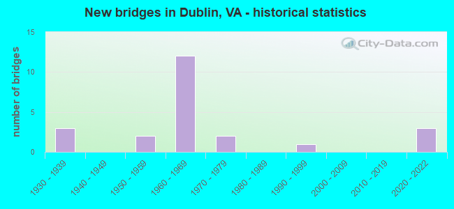
- New bridges - historical statistics
- 31930-1939
- 21950-1959
- 121960-1969
- 21970-1979
- 11990-1999
- 32020-2022

- Reconstructed bridges - Historical Statistics
- 22000-2009
- 02010-2019
- 12020-2022


- Bridge Condition - Deck
- 9.1%Very good
- 36.4%Good
- 45.5%Satisfactory
- 9.1%Fair

- Bridge Condition - Superstructure
- 9.1%Excellent
- 9.1%Very good
- 18.2%Good
- 36.4%Satisfactory
- 27.3%Fair

- Bridge Condition - Substructure
- 9.1%Excellent
- 18.2%Good
- 45.5%Satisfactory
- 27.3%Fair

- Bridge Condition - Channel
- 16.7%Very good
- 33.3%Good
- 50.0%Satisfactory

- Bridge Condition - Culverts
- 66.7%Good
- 33.3%Satisfactory
Find on map >> Show street view
Structure Number: 1449, Location: 4.38-RT 99; 6.22-MONTG CO (Lat: 37.078583, Lng: -80.692156), Route carried "on" structure: Interstate 81, Year Built: 1965, Status: Open, Structure Length: 7.82m (25.66ft), Average Daily Traffic: 18,994 (year 2020), Truck Traffic: 26%, Average Future Daily Traffic: 26,592 (year 2040), Design Load: HS 20+Mod, Features Intersected: RTE 100
Minimum Vertical Clearance: 30+ m (98+ ft), Kilometerpoint: 158.873, Lanes on structure: 2, Lanes under structure: 4, Base Highway Network: Yes, Owner: State Highway Agency, Approaching Roadway Width: 12.2m (40.0ft), Skew: 3 degrees, Material/Design: Steel, Design/Construction: Stringer/Multi-beam, Number Of Spans In Main Unit: 4, Length of Maximum Span: 21.3m (69.9ft), Curb-To-Curb Width: 11.9m (39.0ft), Out-to-Out Width: 12.9m (42.3ft)
Condition: Deck: Satisfactory, Superstructure: Satisfactory, Substructure: Satisfactory, Operating Rating: 56.2 metric tons, Method Used To Determine Operating Rating: Load and Resistance Factor (LRFR), Inventory Rating: 43.5 metric tons, Method Used To Determine Inventory Rating: Load and Resistance Factor (LRFR), Structural Evaluation: Equal to present minimum criteria, Deck Geometry: Equal to present minimum criteria, Underclear: Meets minimum limits, Approach Roadway Alignment: Equal to present desirable criteria, Designated Inspection Frequency: Every 24 months, Inspection Date: August 2020, Deck Structure Type: Concrete Cast-file-Place, Wearing Surface/Protective System: Wearing Surface: Latex Concrete
Find on map >> Show street view
Structure Number: 14503, Location: 1.01-Rte660; 2.79-Mont Co (Lat: 37.088583, Lng: -80.632531), Route carried "on" structure: Interstate 81, Year Built: 1965, Status: Open, Structure Length: 0.82m (2.69ft), Average Daily Traffic: 17,025 (year 2020), Truck Traffic: 23%, Average Future Daily Traffic: 23,835 (year 2040), Design Load: HS 20, Features Intersected: Branch of Claytor Lake
Minimum Vertical Clearance: 30+ m (98+ ft), Kilometerpoint: 165.309, Lanes on structure: 2, Base Highway Network: Yes, Owner: State Highway Agency, Approaching Roadway Width: 11.0m (36.1ft), Skew: 4 degrees, Material/Design: Concrete, Design/Construction: Culvert, Number Of Spans In Main Unit: 3, Length of Maximum Span: 2.6m (8.5ft)
Condition: Channel: Satisfactory, Culverts: Satisfactory, Operating Rating: 89.8 metric tons, Method Used To Determine Operating Rating: Field evaluation and documented engineering judgment, Inventory Rating: 89.8 metric tons, Method Used To Determine Inventory Rating: Field evaluation and documented engineering judgment, Structural Evaluation: Equal to present minimum criteria, Waterway Adequacy: Better than present minimum criteria, Approach Roadway Alignment: Equal to present desirable criteria, Length Of Structure Improvement: 0.82m (2.69ft), Designated Inspection Frequency: Every 24 months, Inspection Date: March 2021, Bridge Improvement Cost: $339,000, Roadway Improvement Cost: $136,000, Total Project Cost: $1,169,000 ( Estimate for 2019)
Find on map >> Show street view
Structure Number: 1451, Location: 4.89-Dublin; 3.71-Giles C (Lat: 37.166844, Lng: -80.701953), Route carried "on" structure: State highway 100, Year Built: 1936, Year Reconstructed: 2007, Status: Open, Structure Length: 3.88m (12.73ft), Average Daily Traffic: 2,230 (year 2020), Truck Traffic: 6%, Average Future Daily Traffic: 3,122 (year 2040), Design Load: HL 93, Features Intersected: Back Creek
Minimum Vertical Clearance: 30+ m (98+ ft), Kilometerpoint: 54.320, Lanes on structure: 2, Base Highway Network: Yes, Owner: State Highway Agency, Approaching Roadway Width: 9.4m (30.8ft), Material/Design: Prestressed concrete, Design/Construction: Slab, Number Of Spans In Main Unit: 3, Length of Maximum Span: 13.0m (42.7ft), Curb or Sidewalk Widths: Left: 0.4m (1.3ft), Right: 0.4m (1.3ft), Curb-To-Curb Width: 8.7m (28.5ft), Out-to-Out Width: 9.4m (30.8ft)
Condition: Deck: Good, Superstructure: Good, Substructure: Satisfactory, Channel: Satisfactory, Operating Rating: 69.9 metric tons, Method Used To Determine Operating Rating: Load and Resistance Factor (LRFR), Inventory Rating: 53.5 metric tons, Method Used To Determine Inventory Rating: Load and Resistance Factor (LRFR), Structural Evaluation: Equal to present minimum criteria, Deck Geometry: High priority of corrective action, Waterway Adequacy: Equal to present minimum criteria, Approach Roadway Alignment: Equal to present desirable criteria, Length Of Structure Improvement: 3.96m (12.99ft), Designated Inspection Frequency: Every 24 months, Inspection Date: September 2021, Bridge Improvement Cost: $1,817,000, Roadway Improvement Cost: $636,000, Total Project Cost: $5,905,000 ( Estimate for 2021), Deck Structure Type: Concrete Precast Panels, Wearing Surface/Protective System: Wearing Surface: Bituminous
Find on map >> Show street view
Structure Number: 14524, Location: 0.54-S DBLN; 0.18-N DBLN (Lat: 37.102419, Lng: -80.691028), Route carried "on" structure: State highway 100, Year Built: 1966, Year Reconstructed: 2007, Status: Open, Structure Length: 2.71m (8.89ft), Average Daily Traffic: 2,524 (year 2020), Truck Traffic: 9%, Average Future Daily Traffic: 3,534 (year 2040), Design Load: HS 20+Mod, Features Intersected: RTE 11 @ DUBLIN
Minimum Vertical Clearance: 30+ m (98+ ft), Kilometerpoint: 46.162, Lanes on structure: 2, Lanes under structure: 4, Base Highway Network: Yes, Owner: State Highway Agency, Approaching Roadway Width: 12.8m (42.0ft), Skew: 3 degrees, Material/Design: Prestressed concrete, Design/Construction: Box Beam or Girders - Single/Spread, Number Of Spans In Main Unit: 2, Length of Maximum Span: 13.4m (44.0ft), Curb or Sidewalk Widths: Left: 1.2m (3.9ft), Right: 4.9m (16.1ft), Curb-To-Curb Width: 12.8m (42.0ft), Out-to-Out Width: 14.3m (46.9ft)
Condition: Deck: Satisfactory, Superstructure: Satisfactory, Substructure: Satisfactory, Operating Rating: 62.6 metric tons, Method Used To Determine Operating Rating: Load and Resistance Factor (LRFR), Inventory Rating: 48.1 metric tons, Method Used To Determine Inventory Rating: Load and Resistance Factor (LRFR), Structural Evaluation: Equal to present minimum criteria, Deck Geometry: Equal to present desirable criteria, Underclear: High priority of corrective action, Approach Roadway Alignment: Equal to present desirable criteria, Length Of Structure Improvement: 3.66m (12.01ft), Designated Inspection Frequency: Every 24 months, Inspection Date: October 2020, Bridge Improvement Cost: $1,552,000, Roadway Improvement Cost: $466,000, Total Project Cost: $4,222,000 ( Estimate for 2014), Deck Structure Type: Concrete Cast-file-Place, Wearing Surface/Protective System: Wearing Surface: Latex Concrete
Find on map >> Show street view
Structure Number: 14526, Location: 0.46-S DUBLIN; 0.08-RT11 (Lat: 37.101244, Lng: -80.690961), Route carried "on" structure: State highway 100, Year Built: 1966, Status: Open, Structure Length: 5.96m (19.55ft), Average Daily Traffic: 7,588 (year 2020), Truck Traffic: 9%, Average Future Daily Traffic: 10,625 (year 2040), Features Intersected: NS RAILWAY & RTE 689
Minimum Vertical Clearance: 30+ m (98+ ft), Kilometerpoint: 46.001, Lanes on structure: 2, Lanes under structure: 2, Base Highway Network: Yes, Owner: State Highway Agency, Approaching Roadway Width: 11.0m (36.1ft), Skew: 1 degrees, Material/Design: Steel, Design/Construction: Stringer/Multi-beam, Number Of Spans In Main Unit: 4, Length of Maximum Span: 16.2m (53.1ft), Curb or Sidewalk Widths: Left: 1.2m (3.9ft), Right: 0.5m (1.6ft), Curb-To-Curb Width: 8.8m (28.9ft), Out-to-Out Width: 11.1m (36.4ft)
Condition: Deck: Fair, Superstructure: Fair, Substructure: Fair, Operating Rating: 50.8 metric tons, Method Used To Determine Operating Rating: Load and Resistance Factor (LRFR), Inventory Rating: 39.0 metric tons, Method Used To Determine Inventory Rating: Load and Resistance Factor (LRFR), Structural Evaluation: Somewhat better than minimum adequacy, Deck Geometry: High priority of corrective action, Underclear: High priority of replacement, Approach Roadway Alignment: Equal to present minimum criteria, Length Of Structure Improvement: 6.98m (22.90ft), Designated Inspection Frequency: Every 24 months, Inspection Date: January 2021, Bridge Improvement Cost: $4,405,000, Roadway Improvement Cost: $1,542,000, Total Project Cost: $14,537,000 ( Estimate for 2019), Deck Structure Type: Concrete Cast-file-Place, Wearing Surface/Protective System: Wearing Surface: Latex Concrete
Find on map >> Show street view
Structure Number: 14544, Location: 0.18-RT 662; 0.02-RT 682 (Lat: 37.079686, Lng: -80.683539), Route carried "on" structure: County highway 611, Year Built: 1965, Status: Open, Structure Length: 7.56m (24.80ft), Average Daily Traffic: 908 (year 2020), Truck Traffic: 4%, Average Future Daily Traffic: 999 (year 2040), Design Load: HS 15, Features Intersected: RTE I 81
Minimum Vertical Clearance: 30+ m (98+ ft), Kilometerpoint: 4.512, Lanes on structure: 2, Lanes under structure: 4, Owner: State Highway Agency, Approaching Roadway Width: 7.3m (24.0ft), Material/Design: Steel, Design/Construction: Stringer/Multi-beam, Number Of Spans In Main Unit: 4, Length of Maximum Span: 23.2m (76.1ft), Curb or Sidewalk Widths: Left: 0.5m (1.6ft), Right: 1.5m (4.9ft), Curb-To-Curb Width: 8.5m (27.9ft), Out-to-Out Width: 10.5m (34.4ft)
Condition: Deck: Satisfactory, Superstructure: Satisfactory, Substructure: Good, Operating Rating: 39.9 metric tons, Method Used To Determine Operating Rating: Load and Resistance Factor (LRFR), Inventory Rating: 30.8 metric tons, Method Used To Determine Inventory Rating: Load and Resistance Factor (LRFR), Structural Evaluation: Equal to present minimum criteria, Deck Geometry: Somewhat better than minimum adequacy, Underclear: Equal to present minimum criteria, Approach Roadway Alignment: Equal to present desirable criteria, Designated Inspection Frequency: Every 24 months, Inspection Date: March 2020, Deck Structure Type: Concrete Cast-file-Place, Wearing Surface/Protective System: Wearing Surface: Latex Concrete
Find on map >> Show street view
Structure Number: 14561, Location: 1.75-Rte100; 0.45-end rte (Lat: 37.146233, Lng: -80.712925), Route carried "on" structure: County highway 628, Year Built: 1932, Status: Open, Structure Length: 1.38m (4.53ft), Average Daily Traffic: 156 (year 2014), Average Future Daily Traffic: 237 (year 2040), Features Intersected: Back Creek
Minimum Vertical Clearance: 30+ m (98+ ft), Kilometerpoint: 2.816, Lanes on structure: 1, Owner: State Highway Agency, Approaching Roadway Width: 3.7m (12.1ft), Material/Design: Steel, Design/Construction: Stringer/Multi-beam, Number Of Spans In Main Unit: 2, Length of Maximum Span: 6.9m (22.6ft), Curb or Sidewalk Widths: Left: 0.3m (1.0ft), Right: 0.3m (1.0ft), Curb-To-Curb Width: 3.9m (12.8ft), Out-to-Out Width: 4.7m (15.4ft)
Condition: Deck: Very good, Superstructure: Very good, Substructure: Satisfactory, Channel: Good, Operating Rating: 76.2 metric tons, Method Used To Determine Operating Rating: Load and Resistance Factor (LRFR), Inventory Rating: 58.1 metric tons, Method Used To Determine Inventory Rating: Load and Resistance Factor (LRFR), Structural Evaluation: Equal to present minimum criteria, Deck Geometry: High priority of replacement, Waterway Adequacy: Equal to present minimum criteria, Approach Roadway Alignment: Equal to present minimum criteria, Length Of Structure Improvement: 1.38m (4.53ft), Designated Inspection Frequency: Every 24 months, Inspection Date: September 2020, Bridge Improvement Cost: $9,000, Roadway Improvement Cost: $1,000, Total Project Cost: $12,000 ( Estimate for 2020), Deck Structure Type: Wood or Timber, Wearing Surface/Protective System: Wearing Surface: Bituminous
Find on map >> Show street view
Structure Number: 14575, Location: 0.05-Rte11; 0.03-Rte638 (Lat: 37.098547, Lng: -80.720292), Route carried "on" structure: County highway 643, Year Built: 1974, Status: Open, Structure Length: 0.64m (2.10ft), Average Daily Traffic: 5,505 (year 2020), Truck Traffic: 2%, Average Future Daily Traffic: 6,632 (year 2040), Features Intersected: Streamather Branch
Minimum Vertical Clearance: 30+ m (98+ ft), Kilometerpoint: 4.119, Lanes on structure: 2, Owner: State Highway Agency, Approaching Roadway Width: 6.7m (22.0ft), Material/Design: Steel, Design/Construction: Culvert, Number Of Spans In Main Unit: 3, Length of Maximum Span: 1.7m (5.6ft)
Condition: Channel: Good, Culverts: Good, Operating Rating: 89.8 metric tons, Method Used To Determine Operating Rating: Field evaluation and documented engineering judgment, Inventory Rating: 89.8 metric tons, Method Used To Determine Inventory Rating: Field evaluation and documented engineering judgment, Structural Evaluation: Better than present minimum criteria, Waterway Adequacy: Equal to present desirable criteria, Approach Roadway Alignment: Equal to present desirable criteria, Designated Inspection Frequency: Every 24 months, Inspection Date: January 2022
Find on map >> Show street view
Structure Number: 14576, Location: 0.50-Rte807; 1.25-Rte611 (Lat: 37.083783, Lng: -80.710403), Route carried "on" structure: County highway 643, Year Built: 1975, Status: Open, Structure Length: 4.02m (13.19ft), Average Daily Traffic: 5,505 (year 2020), Truck Traffic: 2%, Average Future Daily Traffic: 6,632 (year 2040), Design Load: HS 20+Mod, Features Intersected: NS Railway
Minimum Vertical Clearance: 30+ m (98+ ft), Kilometerpoint: 1.995, Lanes on structure: 2, Owner: State Highway Agency, Approaching Roadway Width: 7.3m (24.0ft), Material/Design: Steel, Design/Construction: Stringer/Multi-beam, Number Of Spans In Main Unit: 3, Length of Maximum Span: 15.2m (49.9ft), Curb-To-Curb Width: 9.8m (32.2ft), Out-to-Out Width: 11.0m (36.1ft)
Condition: Deck: Good, Superstructure: Fair, Substructure: Fair, Operating Rating: 60.8 metric tons, Method Used To Determine Operating Rating: Load and Resistance Factor (LRFR), Inventory Rating: 46.3 metric tons, Method Used To Determine Inventory Rating: Load and Resistance Factor (LRFR), Structural Evaluation: Somewhat better than minimum adequacy, Deck Geometry: Meets minimum limits, Underclear: Somewhat better than minimum adequacy, Approach Roadway Alignment: Equal to present desirable criteria, Designated Inspection Frequency: Every 24 months, Inspection Date: June 2020, Deck Structure Type: Concrete Cast-file-Place, Wearing Surface/Protective System: Wearing Surface: Latex Concrete
Find on map >> Show street view
Structure Number: 14593, Location: 0.38-RT 611; 1.22-RT 661 (Lat: 37.084042, Lng: -80.649544), Route carried "on" structure: County highway 660, Year Built: 1965, Status: Open, Structure Length: 7.90m (25.92ft), Average Daily Traffic: 1,714 (year 2020), Truck Traffic: 6%, Average Future Daily Traffic: 1,885 (year 2040), Design Load: HS 20, Features Intersected: RTE I 81
Minimum Vertical Clearance: 30+ m (98+ ft), Kilometerpoint: 9.673, Lanes on structure: 2, Lanes under structure: 4, Owner: State Highway Agency, Approaching Roadway Width: 7.3m (24.0ft), Material/Design: Steel, Design/Construction: Stringer/Multi-beam, Number Of Spans In Main Unit: 4, Length of Maximum Span: 22.3m (73.2ft), Curb or Sidewalk Widths: Left: 0.5m (1.6ft), Right: 0.5m (1.6ft), Curb-To-Curb Width: 9.1m (29.9ft), Out-to-Out Width: 10.7m (35.1ft)
Condition: Deck: Satisfactory, Superstructure: Fair, Substructure: Fair, Operating Rating: 58.1 metric tons, Method Used To Determine Operating Rating: Load and Resistance Factor (LRFR), Inventory Rating: 44.5 metric tons, Method Used To Determine Inventory Rating: Load and Resistance Factor (LRFR), Structural Evaluation: Somewhat better than minimum adequacy, Deck Geometry: Somewhat better than minimum adequacy, Underclear: Equal to present minimum criteria, Approach Roadway Alignment: Equal to present desirable criteria, Designated Inspection Frequency: Every 24 months, Inspection Date: March 2020, Deck Structure Type: Concrete Cast-file-Place, Wearing Surface/Protective System: Wearing Surface: Latex Concrete
Find on map >> Show street view
Structure Number: 14629, Location: 0.13-Rte11; 0.03-dead end (Lat: 37.097900, Lng: -80.721281), Route carried "on" structure: County highway 1109, Year Built: 1932, Status: Open, Structure Length: 0.67m (2.20ft), Average Daily Traffic: 20 (year 2017), Average Future Daily Traffic: 29 (year 2040), Features Intersected: Branch of Thornspring Br
Minimum Vertical Clearance: 30+ m (98+ ft), Kilometerpoint: 0.209, Lanes on structure: 2, Owner: State Highway Agency, Approaching Roadway Width: 3.4m (11.2ft), Material/Design: Concrete, Design/Construction: Slab, Number Of Spans In Main Unit: 1, Length of Maximum Span: 6.7m (22.0ft), Curb-To-Curb Width: 5.5m (18.0ft), Out-to-Out Width: 6.1m (20.0ft)
Condition: Deck: Good, Superstructure: Good, Substructure: Good, Channel: Very good, Operating Rating: 32.7 metric tons, Method Used To Determine Operating Rating: Field evaluation and documented engineering judgment, Inventory Rating: 32.7 metric tons, Method Used To Determine Inventory Rating: Field evaluation and documented engineering judgment, Structural Evaluation: Better than present minimum criteria, Deck Geometry: Meets minimum limits, Waterway Adequacy: Equal to present desirable criteria, Approach Roadway Alignment: Equal to present desirable criteria, Designated Inspection Frequency: Every 24 months, Inspection Date: January 2022, Deck Structure Type: Concrete Cast-file-Place, Wearing Surface/Protective System: Wearing Surface: Bituminous
Find on map >> Show street view
Structure Number: 25429, Location: 1.30-Rte611; 0.47-deadend (Lat: 37.059558, Lng: -80.678353), Route carried "on" structure: County highway 697, Year Built: 1998, Status: Open, Structure Length: 1.16m (3.81ft), Average Daily Traffic: 174 (year 2017), Average Future Daily Traffic: 194 (year 2040), Design Load: HS 20+Mod, Features Intersected: Branch of Claytor Lake
Minimum Vertical Clearance: 30+ m (98+ ft), Kilometerpoint: 0.756, Lanes on structure: 2, Owner: State Highway Agency, Approaching Roadway Width: 5.5m (18.0ft), Skew: 2 degrees, Material/Design: Concrete, Design/Construction: Culvert, Number Of Spans In Main Unit: 4, Length of Maximum Span: 2.7m (8.9ft)
Condition: Channel: Satisfactory, Culverts: Good, Operating Rating: 67.1 metric tons, Method Used To Determine Operating Rating: Load Factor (LF), Inventory Rating: 39.9 metric tons, Method Used To Determine Inventory Rating: Load Factor (LF), Structural Evaluation: Better than present minimum criteria, Waterway Adequacy: Equal to present desirable criteria, Approach Roadway Alignment: Equal to present desirable criteria, Designated Inspection Frequency: Every 24 months, Inspection Date: June 2020
Find on map >> Show street view
Structure Number: 29514, Location: 0.54-SDublin;0.18-NDublin (Lat: 37.102522, Lng: -80.690867), Route carried "on" structure: State highway 100, Year Built: 1950, Year Reconstructed: 2020, Status: Open, Structure Length: 2.72m (8.92ft), Average Daily Traffic: 2,524 (year 2020), Truck Traffic: 9%, Average Future Daily Traffic: 3,534 (year 2040), Design Load: HL 93, Features Intersected: Rte 11
Minimum Vertical Clearance: 30+ m (98+ ft), Kilometerpoint: 47.771, Lanes on structure: 2, Lanes under structure: 4, Owner: State Highway Agency, Approaching Roadway Width: 8.5m (27.9ft), Skew: 13 degrees, Material/Design: Prestressed concrete, Design/Construction: Box Beam or Girders - Multiple, Number Of Spans In Main Unit: 2, Length of Maximum Span: 13.7m (44.9ft), Curb or Sidewalk Widths: Left: 1.8m (5.9ft), Right: 0.2m (0.7ft), Curb-To-Curb Width: 9.4m (30.8ft), Out-to-Out Width: 11.8m (38.7ft)
Condition: Deck: Satisfactory, Superstructure: Satisfactory, Substructure: Satisfactory, Operating Rating: 89.8 metric tons, Method Used To Determine Operating Rating: Load and Resistance Factor (LRFR), Inventory Rating: 88.9 metric tons, Method Used To Determine Inventory Rating: Load and Resistance Factor (LRFR), Structural Evaluation: Equal to present minimum criteria, Deck Geometry: Meets minimum limits, Underclear: Meets minimum limits, Approach Roadway Alignment: Equal to present desirable criteria, Designated Inspection Frequency: Every 24 months, Inspection Date: September 2020, Deck Structure Type: Concrete Cast-file-Place, Wearing Surface/Protective System: Wearing Surface: Monolithic Concrete, Deck Protection: Other
Find on map >> Show street view
Structure Number: 30245, Location: 0.46 S Dublin; .08 Rte 11 (Lat: 37.101294, Lng: -80.690786), Route carried "on" structure: State highway 100, Year Built: 2020, Status: Open, Structure Length: 4.57m (14.99ft), Average Daily Traffic: 7,588 (year 2020), Truck Traffic: 9%, Average Future Daily Traffic: 10,625 (year 2040), Design Load: HL 93, Features Intersected: NSRR & Rte 689
Minimum Vertical Clearance: 30+ m (98+ ft), Kilometerpoint: 46.001, Lanes on structure: 2, Lanes under structure: 4, Owner: State Highway Agency, Approaching Roadway Width: 10.4m (34.1ft), Skew: 1 degrees, Material/Design: Steel continuous, Design/Construction: Stringer/Multi-beam, Number Of Spans In Main Unit: 1, Length of Maximum Span: 45.1m (148.0ft), Curb or Sidewalk Widths: Left: 0.2m (0.7ft), Right: 1.8m (5.9ft), Curb-To-Curb Width: 9.1m (29.9ft), Out-to-Out Width: 11.5m (37.7ft)
Condition: Deck: Good, Superstructure: Excellent, Substructure: Excellent, Operating Rating: 74.4 metric tons, Method Used To Determine Operating Rating: Load and Resistance Factor (LRFR), Inventory Rating: 58.1 metric tons, Method Used To Determine Inventory Rating: Load and Resistance Factor (LRFR), Structural Evaluation: Superior to present desirable criteria, Deck Geometry: Meets minimum limits, Underclear: Equal to present minimum criteria, Approach Roadway Alignment: Equal to present desirable criteria, Designated Inspection Frequency: Every 24 months, Inspection Date: September 2020, Deck Structure Type: Concrete Cast-file-Place, Wearing Surface/Protective System: Wearing Surface: Monolithic Concrete, Deck Protection: Other
Find on map >> Show street view
Structure Number: 1449, Location: 4.38-RT 99; 6.22-MONTG CO (Lat: 37.078583, Lng: -80.692156), Route carried "under" structure: State highway 100, Year Built: 1965, Structure Length: 0. m, Average Daily Traffic: 6,000 (year 2017), Truck Traffic: 9%, Features Intersected: RTE 100, Facility Carried by Structure: NBL ROUTE 0081
Minimum Vertical Clearance: 4.83m (15.85ft), Kilometerpoint: 43.395, Lanes on structure: 2, Lanes under structure: 4, Material/Design: Steel, Design/Construction: Stringer/Multi-beam, Length of Maximum Span: 21.3m (69.9ft)
Find on map >> Show street view
Structure Number: 14492, Location: 4.38-RT 99; 6.22-MONTG CO (Lat: 37.078961, Lng: -80.692025), Route carried "under" structure: State highway 100, Year Built: 1965, Structure Length: 0. m, Average Daily Traffic: 6,000 (year 2017), Truck Traffic: 9%, Features Intersected: RTE 100, Facility Carried by Structure: SBL ROUTE 0081
Minimum Vertical Clearance: 5.16m (16.93ft), Kilometerpoint: 43.427, Lanes on structure: 2, Lanes under structure: 4, Material/Design: Steel, Design/Construction: Stringer/Multi-beam, Length of Maximum Span: 20.4m (66.9ft)
Find on map >> Show street view
Structure Number: 14524, Location: 0.54-S DBLN; 0.18-N DBLN (Lat: 37.102419, Lng: -80.691028), Route carried "under" structure: US 11, Year Built: 1966, Structure Length: 0. m, Average Daily Traffic: 7,050 (year 2008), Truck Traffic: 1%, Features Intersected: RTE 11 @ DUBLIN, Facility Carried by Structure: ClebourneBlvd/100
Minimum Vertical Clearance: 4.70m (15.42ft), Kilometerpoint: 161.640, Lanes on structure: 2, Lanes under structure: 4, Material/Design: Prestressed concrete, Design/Construction: Box Beam or Girders - Single/Spread, Length of Maximum Span: 13.4m (44.0ft)
Find on map >> Show street view
Structure Number: 14526, Location: 0.46-S DUBLIN; 0.08-RT11 (Lat: 37.101244, Lng: -80.690961), Route carried "under" structure: County highway 689, Year Built: 1966, Structure Length: 0. m, Average Daily Traffic: 120 (year 1994), Features Intersected: NS RAILWAY & RTE 689, Facility Carried by Structure: CLEBURNE BLVD./100
Minimum Vertical Clearance: 9.44m (30.97ft), Kilometerpoint: 0.000, Lanes on structure: 2, Lanes under structure: 2, Material/Design: Steel, Design/Construction: Stringer/Multi-beam, Length of Maximum Span: 16.2m (53.1ft)
Find on map >> Show street view
Structure Number: 14544, Location: 0.18-RT 662; 0.02-RT 682 (Lat: 37.079686, Lng: -80.683539), Route carried "under" structure: Interstate 81, Year Built: 1965, Structure Length: 0. m, Average Daily Traffic: 22,260 (year 1994), Features Intersected: RTE I 81, Facility Carried by Structure: NEWBERN ROAD/611
Minimum Vertical Clearance: 5.39m (17.68ft), Kilometerpoint: 18.970, Lanes on structure: 2, Lanes under structure: 4, Material/Design: Steel, Design/Construction: Stringer/Multi-beam, Length of Maximum Span: 23.2m (76.1ft)
Find on map >> Show street view
Structure Number: 14593, Location: 0.38-RT 611; 1.22-RT 661 (Lat: 37.084042, Lng: -80.649544), Route carried "under" structure: Interstate 81, Year Built: 1965, Structure Length: 0. m, Average Daily Traffic: 23,525 (year 1994), Features Intersected: RTE I 81, Facility Carried by Structure: STATE PARK RD/660
Minimum Vertical Clearance: 5.23m (17.16ft), Kilometerpoint: 22.108, Lanes on structure: 2, Lanes under structure: 4, Material/Design: Steel, Design/Construction: Stringer/Multi-beam, Length of Maximum Span: 22.3m (73.2ft)
Find on map >> Show street view
Structure Number: 29514, Location: 0.54-SDublin;0.18-NDublin (Lat: 37.102522, Lng: -80.690867), Route carried "under" structure: US 11, Year Built: 1950, Structure Length: 0. m, Average Daily Traffic: 14,000 (year 2017), Truck Traffic: 2%, Features Intersected: Rte 11, Facility Carried by Structure: 100NBL/ClebourneBV
Minimum Vertical Clearance: 4.85m (15.91ft), Kilometerpoint: 47.771, Lanes on structure: 2, Lanes under structure: 4, Material/Design: Prestressed concrete, Design/Construction: Box Beam or Girders - Multiple, Length of Maximum Span: 13.7m (44.9ft)
Find on map >> Show street view
Structure Number: 30245, Location: 0.46 S Dublin; .08 Rte 11 (Lat: 37.101294, Lng: -80.690786), Route carried "under" structure: County highway 689, Year Built: 2020, Structure Length: 0. m, Average Daily Traffic: 320 (year 1994), Features Intersected: NSRR & Rte 689, Facility Carried by Structure: 100NBL/ClebourneBV
Minimum Vertical Clearance: 8.86m (29.07ft), Kilometerpoint: 0.000, Lanes on structure: 2, Lanes under structure: 2, Material/Design: Steel continuous, Design/Construction: Stringer/Multi-beam, Length of Maximum Span: 45.1m (148.0ft)
Find on map >> Show street view
Structure Number: 30245, Location: 0.46 S Dublin; .08 Rte 11 (Lat: 37.101294, Lng: -80.690786), Route carried "under" structure: Other road , Year Built: 2020, Structure Length: 0. m, Average Daily Traffic: 320 (year 1994), Features Intersected: NSRR & Rte 689, Facility Carried by Structure: 100NBL/ClebourneBV
Minimum Vertical Clearance: 7.62m (25.00ft), Kilometerpoint: 0.000, Lanes on structure: 2, Lanes under structure: 2, Material/Design: Steel continuous, Design/Construction: Stringer/Multi-beam, Length of Maximum Span: 45.1m (148.0ft)