Bridge Statistics for Dumas, Mississippi (MS)
Condition, Traffic, Stress, Structural Evaluation, Project Costs
- National Bridge Inventory (NBI) Statistics
- 19Number of bridges
- 131ft / 39.5mTotal length
- $156,000Total costs
- 3,390Total average daily traffic
- 336Total average daily truck traffic
- 4,105Total future (year 2034) average daily traffic
- National Bridge Inventory (NBI) Registered Bridges for Dumas
- No street view available for this location
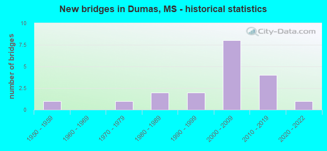
- New bridges - historical statistics
- 11950-1959
- 11970-1979
- 21980-1989
- 21990-1999
- 82000-2009
- 42010-2019
- 12020-2022

- Bridge Condition - Deck
- 20.0%Very good
- 70.0%Good
- 10.0%Fair

- Bridge Condition - Superstructure
- 60.0%Very good
- 20.0%Good
- 20.0%Satisfactory

- Bridge Condition - Substructure
- 50.0%Very good
- 50.0%Good

- Bridge Condition - Channel
- 15.8%Very good
- 63.2%Good
- 15.8%Satisfactory
- 5.3%Fair

- Bridge Condition - Culverts
- 11.1%Very good
- 88.9%Good
Find on map >> Show street view
Structure Number: 3100030073046, Location: 12.6 MI E SR15 (Lat: 34.564281, Lng: -88.826414), Route carried "on" structure: State highway 30, Year Built: 1955, Status: Open, Structure Length: 0.63m (2.07ft), Average Daily Traffic: 2,100 (year 2020), Truck Traffic: 14%, Average Future Daily Traffic: 2,200 (year 2040), Design Load: H 15, Features Intersected: CREEK
Minimum Vertical Clearance: 30+ m (98+ ft), Kilometerpoint: 43.167, Lanes on structure: 2, Base Highway Network: Yes (Inventory Route: 3, Subroute: 2), Owner: State Highway Agency, Approaching Roadway Width: 10.4m (34.1ft), Skew: 3 degrees, Material/Design: Concrete, Design/Construction: Culvert, Number Of Spans In Main Unit: 1, Length of Maximum Span: 5.5m (18.0ft)
Condition: Channel: Good, Culverts: Good, Operating Rating: 76.6 metric tons, Method Used To Determine Operating Rating: Load Factor (LF), Inventory Rating: 45.8 metric tons, Method Used To Determine Inventory Rating: Load Factor (LF), Structural Evaluation: Better than present minimum criteria, Waterway Adequacy: Superior to present desirable criteria, Approach Roadway Alignment: Equal to present desirable criteria, Designated Inspection Frequency: Every 24 months, Inspection Date: December 2021
Find on map >> Show street view
Structure Number: SA7000000000066, Location: SEC 32 T 4S R 5E (Lat: 34.689583, Lng: -88.799833), Route carried "on" structure: County highway 17, Year Built: 2001, Status: Open, Structure Length: 4.72m (15.49ft), Average Daily Traffic: 60 (year 2021), Average Future Daily Traffic: 90 (year 2040), Design Load: HS 20, Features Intersected: BURTON BRANCH, Facility Carried by Structure: CR 610
Minimum Vertical Clearance: 30+ m (98+ ft), Kilometerpoint: 4.184, Lanes on structure: 2, Owner: County Highway Agency, Approaching Roadway Width: 6.7m (22.0ft), Skew: 3 degrees, Material/Design: Concrete, Design/Construction: Channel Beam, Number Of Spans In Main Unit: 5, Length of Maximum Span: 9.4m (30.8ft), Curb or Sidewalk Widths: Left: 0.5m (1.6ft), Right: 0.5m (1.6ft), Curb-To-Curb Width: 8.5m (27.9ft), Out-to-Out Width: 9.5m (31.2ft)
Condition: Deck: Very good, Superstructure: Very good, Substructure: Good, Channel: Very good, Operating Rating: 63.1 metric tons, Method Used To Determine Operating Rating: Load Factor (LF), Inventory Rating: 37.9 metric tons, Method Used To Determine Inventory Rating: Load Factor (LF), Structural Evaluation: Better than present minimum criteria, Deck Geometry: Better than present minimum criteria, Waterway Adequacy: Equal to present desirable criteria, Approach Roadway Alignment: Equal to present minimum criteria, Designated Inspection Frequency: Every 24 months, Inspection Date: October 2021, Deck Structure Type: Concrete Precast Panels, Wearing Surface/Protective System: Wearing Surface: Monolithic Concrete
Find on map >> Show street view
Structure Number: SA7000000000067, Location: SEC 32 T 4S R 5E B (Lat: 34.690556, Lng: -88.798611), Route carried "on" structure: County highway 19, Year Built: 1984, Status: Open, Structure Length: 4.33m (14.21ft), Average Daily Traffic: 160 (year 2015), Truck Traffic: 8%, Average Future Daily Traffic: 240 (year 2035), Design Load: HS 20, Features Intersected: CLEAR CREEK, Facility Carried by Structure: CR 615
Minimum Vertical Clearance: 30+ m (98+ ft), Kilometerpoint: 3.218, Lanes on structure: 2, Owner: County Highway Agency, Approaching Roadway Width: 6.7m (22.0ft), Material/Design: Prestressed concrete, Design/Construction: Stringer/Multi-beam, Number Of Spans In Main Unit: 4, Length of Maximum Span: 12.2m (40.0ft), Curb or Sidewalk Widths: Left: 0.5m (1.6ft), Right: 0.5m (1.6ft), Curb-To-Curb Width: 8.5m (27.9ft), Out-to-Out Width: 9.5m (31.2ft)
Condition: Deck: Good, Superstructure: Very good, Substructure: Very good, Channel: Good, Operating Rating: 61.8 metric tons, Method Used To Determine Operating Rating: Load Factor (LF), Inventory Rating: 37.6 metric tons, Method Used To Determine Inventory Rating: Load Factor (LF), Structural Evaluation: Equal to present desirable criteria, Deck Geometry: Equal to present minimum criteria, Waterway Adequacy: Equal to present desirable criteria, Approach Roadway Alignment: Equal to present desirable criteria, Designated Inspection Frequency: Every 24 months, Inspection Date: October 2020, Deck Structure Type: Concrete Cast-file-Place, Wearing Surface/Protective System: Wearing Surface: Monolithic Concrete
Find on map >> Show street view
Structure Number: SA7000000000068, Location: SEC 32 T 4S R 5E B (Lat: 34.691389, Lng: -88.798889), Route carried "on" structure: County highway 19, Year Built: 1984, Status: Open, Structure Length: 0.80m (2.62ft), Average Daily Traffic: 160 (year 2021), Truck Traffic: 8%, Average Future Daily Traffic: 240 (year 2040), Design Load: HS 20, Features Intersected: FRYAR BRANCH, Facility Carried by Structure: CR 615
Minimum Vertical Clearance: 30+ m (98+ ft), Kilometerpoint: 3.379, Lanes on structure: 2, Owner: County Highway Agency, Approaching Roadway Width: 6.1m (20.0ft), Material/Design: Concrete, Design/Construction: Culvert, Number Of Spans In Main Unit: 2, Length of Maximum Span: 3.7m (12.1ft)
Condition: Channel: Satisfactory, Culverts: Very good, Operating Rating: 71.6 metric tons, Method Used To Determine Operating Rating: Load Factor (LF), Inventory Rating: 42.8 metric tons, Method Used To Determine Inventory Rating: Load Factor (LF), Structural Evaluation: Equal to present desirable criteria, Waterway Adequacy: Equal to present desirable criteria, Approach Roadway Alignment: Equal to present desirable criteria, Designated Inspection Frequency: Every 24 months, Inspection Date: October 2021
Find on map >> Show street view
Structure Number: SA7000000000087, Location: SEC 9 T 5S R 4E (Lat: 34.655028, Lng: -88.889250), Route carried "on" structure: County highway 113, Year Built: 2002, Status: Posted for load, Structure Length: 1.19m (3.90ft), Average Daily Traffic: 20 (year 2015), Truck Traffic: 10%, Average Future Daily Traffic: 30 (year 2035), Design Load: H 10, Features Intersected: TALLAHATCHIE RELIEF, Facility Carried by Structure: CR 738
Minimum Vertical Clearance: 30+ m (98+ ft), Kilometerpoint: 2.574, Lanes on structure: 2, Owner: County Highway Agency, Approaching Roadway Width: 2.7m (8.9ft), Material/Design: Wood or Timber, Design/Construction: Stringer/Multi-beam, Number Of Spans In Main Unit: 3, Length of Maximum Span: 5.8m (19.0ft), Curb-To-Curb Width: 5.5m (18.0ft), Out-to-Out Width: 5.5m (18.0ft)
Condition: Deck: Fair, Superstructure: Good, Substructure: Good, Channel: Good, Operating Rating: 11.0 metric tons, Method Used To Determine Operating Rating: Allowable Stress (AS), Inventory Rating: 8.3 metric tons, Method Used To Determine Inventory Rating: Allowable Stress (AS), Structural Evaluation: High priority of replacement, Deck Geometry: Meets minimum limits, Waterway Adequacy: Better than present minimum criteria, Approach Roadway Alignment: Better than present minimum criteria, Bridge Posting: Required (Relationship of Operating Rating to Maximum Legal Load: > 39.9% below), Length Of Structure Improvement: 2.10m (6.89ft), Designated Inspection Frequency: Every 12 months, Inspection Date: October 2021, Bridge Improvement Cost: $125,000, Roadway Improvement Cost: $15,000, Total Project Cost: $156,000 ( Estimate for 2016), Deck Structure Type: Wood or Timber, Wearing Surface/Protective System: Wearing Surface: Wood or Timber
Find on map >> Show street view
Structure Number: SA7000000000089, Location: SEC 2 T 5S R 4E B (Lat: 34.682850, Lng: -88.842278), Route carried "on" structure: County highway 972, Year Built: 1995, Status: Open, Structure Length: 0.67m (2.20ft), Average Daily Traffic: 80 (year 2021), Average Future Daily Traffic: 120 (year 2040), Design Load: HS 20, Features Intersected: BURTON BRANCH, Facility Carried by Structure: CR 611
Minimum Vertical Clearance: 30+ m (98+ ft), Kilometerpoint: 3.540, Lanes on structure: 2, Owner: County Highway Agency, Approaching Roadway Width: 6.4m (21.0ft), Skew: 3 degrees, Material/Design: Concrete, Design/Construction: Culvert, Number Of Spans In Main Unit: 2, Length of Maximum Span: 3.0m (9.8ft)
Condition: Channel: Satisfactory, Culverts: Good, Operating Rating: 67.3 metric tons, Method Used To Determine Operating Rating: Load Factor (LF), Inventory Rating: 40.2 metric tons, Method Used To Determine Inventory Rating: Load Factor (LF), Structural Evaluation: Better than present minimum criteria, Waterway Adequacy: Equal to present desirable criteria, Approach Roadway Alignment: Equal to present desirable criteria, Designated Inspection Frequency: Every 24 months, Inspection Date: October 2021
Find on map >> Show street view
Structure Number: SA7000000000092, Location: SEC 28 T 5S R 4E B (Lat: 34.623778, Lng: -88.880139), Route carried "on" structure: County highway 939, Year Built: 2003, Status: Open, Structure Length: 4.27m (14.01ft), Average Daily Traffic: 100 (year 2020), Average Future Daily Traffic: 150 (year 2040), Design Load: HS 20, Features Intersected: TALLAHATCHIE RIVER, Facility Carried by Structure: CR 744
Minimum Vertical Clearance: 30+ m (98+ ft), Kilometerpoint: 14.645, Lanes on structure: 2, Owner: County Highway Agency, Approaching Roadway Width: 6.1m (20.0ft), Material/Design: Prestressed concrete, Design/Construction: Stringer/Multi-beam, Number Of Spans In Main Unit: 3, Length of Maximum Span: 18.3m (60.0ft), Curb or Sidewalk Widths: Left: 0.5m (1.6ft), Right: 0.5m (1.6ft), Curb-To-Curb Width: 8.5m (27.9ft), Out-to-Out Width: 9.5m (31.2ft)
Condition: Deck: Good, Superstructure: Very good, Substructure: Very good, Channel: Very good, Operating Rating: 76.1 metric tons, Method Used To Determine Operating Rating: Load Factor (LF), Inventory Rating: 39.6 metric tons, Method Used To Determine Inventory Rating: Load Factor (LF), Structural Evaluation: Equal to present desirable criteria, Deck Geometry: Better than present minimum criteria, Waterway Adequacy: Equal to present desirable criteria, Approach Roadway Alignment: Equal to present minimum criteria, Designated Inspection Frequency: Every 24 months, Inspection Date: October 2021, Deck Structure Type: Concrete Cast-file-Place, Wearing Surface/Protective System: Wearing Surface: Monolithic Concrete
Find on map >> Show street view
Structure Number: SA7000000000094, Location: SEC 34 T 5S R 4E (Lat: 34.606575, Lng: -88.876136), Route carried "on" structure: County highway 120, Year Built: 2004, Status: Open, Structure Length: 0.82m (2.69ft), Average Daily Traffic: 30 (year 2021), Average Future Daily Traffic: 45 (year 2040), Design Load: HS 20, Features Intersected: HALL CREEK, Facility Carried by Structure: CR 745
Minimum Vertical Clearance: 30+ m (98+ ft), Kilometerpoint: 1.770, Lanes on structure: 2, Owner: County Highway Agency, Approaching Roadway Width: 6.7m (22.0ft), Skew: 1 degrees, Material/Design: Concrete, Design/Construction: Culvert, Number Of Spans In Main Unit: 2, Length of Maximum Span: 3.7m (12.1ft)
Condition: Channel: Good, Culverts: Good, Operating Rating: 54.6 metric tons, Method Used To Determine Operating Rating: Load Factor (LF), Inventory Rating: 32.7 metric tons, Method Used To Determine Inventory Rating: Load Factor (LF), Structural Evaluation: Better than present minimum criteria, Waterway Adequacy: Equal to present desirable criteria, Approach Roadway Alignment: Equal to present desirable criteria, Designated Inspection Frequency: Every 24 months, Inspection Date: October 2021
Find on map >> Show street view
Structure Number: SA7000000000095, Location: SEC 34 T 5S R 4E (Lat: 34.607000, Lng: -88.876194), Route carried "on" structure: County highway 120, Year Built: 2004, Status: Open, Structure Length: 1.12m (3.67ft), Average Daily Traffic: 30 (year 2021), Average Future Daily Traffic: 45 (year 2040), Design Load: HS 20, Features Intersected: LITTLE CREEK, Facility Carried by Structure: CR 745
Minimum Vertical Clearance: 30+ m (98+ ft), Kilometerpoint: 1.770, Lanes on structure: 2, Owner: County Highway Agency, Approaching Roadway Width: 6.1m (20.0ft), Skew: 4 degrees, Material/Design: Concrete, Design/Construction: Culvert, Number Of Spans In Main Unit: 2, Length of Maximum Span: 3.7m (12.1ft)
Condition: Channel: Good, Culverts: Good, Operating Rating: 67.3 metric tons, Method Used To Determine Operating Rating: Load Factor (LF), Inventory Rating: 40.2 metric tons, Method Used To Determine Inventory Rating: Load Factor (LF), Structural Evaluation: Better than present minimum criteria, Waterway Adequacy: Equal to present desirable criteria, Approach Roadway Alignment: Equal to present desirable criteria, Designated Inspection Frequency: Every 24 months, Inspection Date: October 2021
Find on map >> Show street view
Structure Number: SA7000000000101, Location: SEC 16 T 5S R 5E (Lat: 34.643578, Lng: -88.784022), Route carried "on" structure: County highway 13, Year Built: 2000, Status: Open, Structure Length: 4.87m (15.98ft), Average Daily Traffic: 150 (year 2021), Truck Traffic: 8%, Average Future Daily Traffic: 225 (year 2040), Design Load: HS 20, Features Intersected: HATCHIE RIVER, Facility Carried by Structure: CR 626
Minimum Vertical Clearance: 30+ m (98+ ft), Kilometerpoint: 1.609, Lanes on structure: 2, Owner: County Highway Agency, Approaching Roadway Width: 6.7m (22.0ft), Skew: 3 degrees, Material/Design: Prestressed concrete, Design/Construction: Stringer/Multi-beam, Number Of Spans In Main Unit: 3, Length of Maximum Span: 24.3m (79.7ft), Curb or Sidewalk Widths: Left: 0.5m (1.6ft), Right: 0.5m (1.6ft), Curb-To-Curb Width: 8.5m (27.9ft), Out-to-Out Width: 9.5m (31.2ft)
Condition: Deck: Good, Superstructure: Very good, Substructure: Very good, Channel: Good, Operating Rating: 84.0 metric tons, Method Used To Determine Operating Rating: Load Factor (LF), Inventory Rating: 38.6 metric tons, Method Used To Determine Inventory Rating: Load Factor (LF), Structural Evaluation: Equal to present desirable criteria, Deck Geometry: Equal to present minimum criteria, Waterway Adequacy: Equal to present desirable criteria, Approach Roadway Alignment: Equal to present desirable criteria, Designated Inspection Frequency: Every 24 months, Inspection Date: October 2021, Deck Structure Type: Concrete Cast-file-Place, Wearing Surface/Protective System: Wearing Surface: Monolithic Concrete
Find on map >> Show street view
Structure Number: SA7000000000134, Location: SEC 7 T 5S R 5E B (Lat: 34.664833, Lng: -88.821650), Route carried "on" structure: County highway 1109, Year Built: 1979, Status: Open, Structure Length: 1.09m (3.58ft), Average Daily Traffic: 60 (year 2021), Average Future Daily Traffic: 90 (year 2040), Design Load: HS 20, Features Intersected: CLEAR CREEK, Facility Carried by Structure: CR 602
Minimum Vertical Clearance: 30+ m (98+ ft), Kilometerpoint: 4.023, Lanes on structure: 2, Owner: County Highway Agency, Approaching Roadway Width: 6.1m (20.0ft), Skew: 1 degrees, Material/Design: Concrete, Design/Construction: Culvert, Number Of Spans In Main Unit: 2, Length of Maximum Span: 4.9m (16.1ft)
Condition: Channel: Good, Culverts: Good, Operating Rating: 58.8 metric tons, Method Used To Determine Operating Rating: Load Factor (LF), Inventory Rating: 35.3 metric tons, Method Used To Determine Inventory Rating: Load Factor (LF), Structural Evaluation: Better than present minimum criteria, Waterway Adequacy: Equal to present desirable criteria, Approach Roadway Alignment: Equal to present desirable criteria, Designated Inspection Frequency: Every 24 months, Inspection Date: October 2021
Find on map >> Show street view
Structure Number: SA7000000000138, Location: SEC 21 T 5S R 4E (Lat: 34.631472, Lng: -88.880194), Route carried "on" structure: County highway 115, Year Built: 2011, Status: Open, Structure Length: 1.29m (4.23ft), Average Daily Traffic: 100 (year 2014), Average Future Daily Traffic: 120 (year 2034), Design Load: HS 20, Features Intersected: TALLAHATCHIE RIVER, Facility Carried by Structure: CR 742
Minimum Vertical Clearance: 30+ m (98+ ft), Kilometerpoint: 0.643, Lanes on structure: 2, Owner: County Highway Agency, Approaching Roadway Width: 6.4m (21.0ft), Material/Design: Concrete, Design/Construction: Arch - Deck, Number Of Spans In Main Unit: 1, Length of Maximum Span: 12.9m (42.3ft), Curb or Sidewalk Widths: Left: 0.3m (1.0ft), Right: 0.3m (1.0ft), Curb-To-Curb Width: 14.1m (46.3ft), Out-to-Out Width: 14.6m (47.9ft)
Condition: Deck: Good, Superstructure: Good, Substructure: Very good, Channel: Good, Operating Rating: 71.7 metric tons, Method Used To Determine Operating Rating: Load Factor (LF), Inventory Rating: 43.0 metric tons, Method Used To Determine Inventory Rating: Load Factor (LF), Structural Evaluation: Better than present minimum criteria, Deck Geometry: Superior to present desirable criteria, Waterway Adequacy: Equal to present desirable criteria, Approach Roadway Alignment: Somewhat better than minimum adequacy, Designated Inspection Frequency: Every 24 months, Inspection Date: December 2021
Find on map >> Show street view
Structure Number: SA700000000A104, Location: SEC 29 T 5S R 5E (Lat: 34.618847, Lng: -88.798722), Route carried "on" structure: County highway 3, Year Built: 2021, Status: Open, Structure Length: 1.12m (3.67ft), Average Daily Traffic: 20 (year 2015), Average Future Daily Traffic: 30 (year 2035), Design Load: HL 93, Features Intersected: HATCHIE RIVER
Minimum Vertical Clearance: 30+ m (98+ ft), Kilometerpoint: 0.160, Lanes on structure: 2, Owner: County Highway Agency, Approaching Roadway Width: 6.1m (20.0ft), Skew: 1 degrees, Material/Design: Concrete, Design/Construction: Culvert, Number Of Spans In Main Unit: 2, Length of Maximum Span: 5.6m (18.4ft)
Condition: Channel: Very good, Culverts: Good, Operating Rating: 60.3 metric tons, Method Used To Determine Operating Rating: Load and Resistance Factor Rating (LRFR) rating reported by rating factor(RF) method using HL-93 loadings, Inventory Rating: 37.9 metric tons, Method Used To Determine Inventory Rating: Load and Resistance Factor Rating (LRFR) rating reported by rating factor(RF) method using HL-93 loadings, Structural Evaluation: Better than present minimum criteria, Waterway Adequacy: Equal to present desirable criteria, Approach Roadway Alignment: Equal to present minimum criteria, Designated Inspection Frequency: Every 24 months, Inspection Date: October 2021
Find on map >> Show street view
Structure Number: SA7300000000036, Location: SEC 4 T 6S R 4E (Lat: 34.593922, Lng: -88.886147), Route carried "on" structure: County highway 39, Year Built: 2007, Status: Open, Structure Length: 4.27m (14.01ft), Average Daily Traffic: 50 (year 2020), Average Future Daily Traffic: 75 (year 2040), Design Load: HS 20, Features Intersected: TALLAHATCHIE CANAL, Facility Carried by Structure: COUNTY ROAD 161
Minimum Vertical Clearance: 30+ m (98+ ft), Kilometerpoint: 0.804, Lanes on structure: 2, Owner: County Highway Agency, Approaching Roadway Width: 6.1m (20.0ft), Material/Design: Prestressed concrete, Design/Construction: Stringer/Multi-beam, Number Of Spans In Main Unit: 3, Length of Maximum Span: 18.3m (60.0ft), Curb-To-Curb Width: 7.9m (25.9ft), Out-to-Out Width: 8.8m (28.9ft)
Condition: Deck: Good, Superstructure: Very good, Substructure: Good, Channel: Good, Operating Rating: 58.6 metric tons, Method Used To Determine Operating Rating: Load Factor (LF) rating reported by rating factor (RF) method using MS18 loading, Inventory Rating: 31.4 metric tons, Method Used To Determine Inventory Rating: Load Factor (LF) rating reported by rating factor (RF) method using MS18 loading, Structural Evaluation: Better than present minimum criteria, Deck Geometry: Equal to present minimum criteria, Waterway Adequacy: Equal to present desirable criteria, Approach Roadway Alignment: Equal to present desirable criteria, Designated Inspection Frequency: Every 24 months, Inspection Date: November 2021, Deck Structure Type: Concrete Cast-file-Place, Wearing Surface/Protective System: Wearing Surface: Monolithic Concrete
Find on map >> Show street view
Structure Number: SA7300000000037, Location: SEC 4 T 6S R 4E (Lat: 34.590397, Lng: -88.877219), Route carried "on" structure: County highway 40, Year Built: 2001, Status: Open, Structure Length: 0.64m (2.10ft), Average Daily Traffic: 50 (year 2020), Average Future Daily Traffic: 75 (year 2040), Design Load: HS 20+Mod, Features Intersected: PICKENS CREEK, Facility Carried by Structure: COUNTY ROAD 162
Minimum Vertical Clearance: 30+ m (98+ ft), Kilometerpoint: 0.804, Lanes on structure: 2, Owner: County Highway Agency, Approaching Roadway Width: 5.5m (18.0ft), Material/Design: Concrete, Design/Construction: Culvert, Number Of Spans In Main Unit: 2, Length of Maximum Span: 3.0m (9.8ft)
Condition: Channel: Satisfactory, Culverts: Good, Operating Rating: 85.9 metric tons, Method Used To Determine Operating Rating: Load Factor (LF) rating reported by rating factor (RF) method using MS18 loading, Inventory Rating: 51.5 metric tons, Method Used To Determine Inventory Rating: Load Factor (LF) rating reported by rating factor (RF) method using MS18 loading, Structural Evaluation: Better than present minimum criteria, Waterway Adequacy: Equal to present desirable criteria, Approach Roadway Alignment: Equal to present minimum criteria, Designated Inspection Frequency: Every 24 months, Inspection Date: November 2021
Find on map >> Show street view
Structure Number: SA7300000000039, Location: SEC 8 T 6S R 4E (Lat: 34.576900, Lng: -88.894456), Route carried "on" structure: County highway 43, Year Built: 2011, Status: Open, Structure Length: 4.27m (14.01ft), Average Daily Traffic: 60 (year 2018), Truck Traffic: 8%, Average Future Daily Traffic: 90 (year 2038), Design Load: HS 20, Features Intersected: TALLAHATCHIE CANAL, Facility Carried by Structure: COUNTY ROAD 242
Minimum Vertical Clearance: 30+ m (98+ ft), Kilometerpoint: 0.321, Lanes on structure: 2, Owner: County Highway Agency, Approaching Roadway Width: 11.0m (36.1ft), Material/Design: Prestressed concrete, Design/Construction: Stringer/Multi-beam, Number Of Spans In Main Unit: 3, Length of Maximum Span: 18.3m (60.0ft), Curb-To-Curb Width: 7.9m (25.9ft), Out-to-Out Width: 8.8m (28.9ft)
Condition: Deck: Good, Superstructure: Very good, Substructure: Good, Channel: Good, Operating Rating: 58.6 metric tons, Method Used To Determine Operating Rating: Load Factor (LF) rating reported by rating factor (RF) method using MS18 loading, Inventory Rating: 31.4 metric tons, Method Used To Determine Inventory Rating: Load Factor (LF) rating reported by rating factor (RF) method using MS18 loading, Structural Evaluation: Better than present minimum criteria, Deck Geometry: Equal to present minimum criteria, Waterway Adequacy: Superior to present desirable criteria, Approach Roadway Alignment: Better than present minimum criteria, Designated Inspection Frequency: Every 24 months, Inspection Date: November 2020, Deck Structure Type: Concrete Cast-file-Place, Wearing Surface/Protective System: Wearing Surface: Monolithic Concrete
Find on map >> Show street view
Structure Number: SA7300000000053, Location: SEC 7 T 6S R 5E B (Lat: 34.581189, Lng: -88.815767), Route carried "on" structure: County highway 32, Year Built: 1993, Year Reconstructed: 2014, Status: Open, Structure Length: 1.26m (4.13ft), Average Daily Traffic: 40 (year 2014), Average Future Daily Traffic: 60 (year 2034), Features Intersected: HATCHIE RIVER, Facility Carried by Structure: COUNTY ROAD 163
Minimum Vertical Clearance: 30+ m (98+ ft), Kilometerpoint: 3.379, Lanes on structure: 2, Owner: County Highway Agency, Approaching Roadway Width: 5.8m (19.0ft), Material/Design: Steel, Design/Construction: Stringer/Multi-beam, Number Of Spans In Main Unit: 1, Length of Maximum Span: 12.6m (41.3ft), Curb-To-Curb Width: 7.9m (25.9ft), Out-to-Out Width: 7.9m (25.9ft)
Condition: Deck: Very good, Superstructure: Satisfactory, Substructure: Good, Channel: Fair, Operating Rating: 44.8 metric tons, Method Used To Determine Operating Rating: Load Factor (LF), Inventory Rating: 26.8 metric tons, Method Used To Determine Inventory Rating: Load Factor (LF), Structural Evaluation: Equal to present minimum criteria, Deck Geometry: Equal to present minimum criteria, Waterway Adequacy: Better than present minimum criteria, Approach Roadway Alignment: Better than present minimum criteria, Designated Inspection Frequency: Every 24 months, Inspection Date: November 2021, Deck Structure Type: Concrete Cast-file-Place, Wearing Surface/Protective System: Wearing Surface: Monolithic Concrete
Find on map >> Show street view
Structure Number: SA730000000A035, Location: SEC 3 T 6S R 4E (Lat: 34.585839, Lng: -88.867531), Route carried "on" structure: County highway 50, Year Built: 2016, Status: Open, Structure Length: 0.92m (3.02ft), Average Daily Traffic: 70 (year 2018), Average Future Daily Traffic: 105 (year 2038), Design Load: HS 20, Features Intersected: BUSSELL CREEK, Facility Carried by Structure: COUNTY ROAD 158
Minimum Vertical Clearance: 30+ m (98+ ft), Kilometerpoint: 4.184, Lanes on structure: 2, Owner: County Highway Agency, Approaching Roadway Width: 4.9m (16.1ft), Material/Design: Concrete, Design/Construction: Culvert, Number Of Spans In Main Unit: 2, Length of Maximum Span: 4.3m (14.1ft)
Condition: Channel: Good, Culverts: Good, Operating Rating: 47.0 metric tons, Method Used To Determine Operating Rating: Load Factor (LF) rating reported by rating factor (RF) method using MS18 loading, Inventory Rating: 28.2 metric tons, Method Used To Determine Inventory Rating: Load Factor (LF) rating reported by rating factor (RF) method using MS18 loading, Structural Evaluation: Better than present minimum criteria, Waterway Adequacy: Somewhat better than minimum adequacy, Approach Roadway Alignment: Somewhat better than minimum adequacy, Designated Inspection Frequency: Every 24 months, Inspection Date: November 2020, Deck Structure Type: Concrete Cast-file-Place, Wearing Surface/Protective System: Wearing Surface: Gravel
Find on map >> Show street view
Structure Number: SA730000000A041, Location: SEC_13_T 6S_R 4E B (Lat: 34.567786, Lng: -88.824561), Route carried "on" structure: County highway 13, Year Built: 2013, Status: Posted for load, Structure Length: 1.25m (4.10ft), Average Daily Traffic: 50 (year 2018), Average Future Daily Traffic: 75 (year 2038), Features Intersected: HATCHIE RIVER, Facility Carried by Structure: COUNTY ROAD 330
Minimum Vertical Clearance: 30+ m (98+ ft), Kilometerpoint: 10.460, Lanes on structure: 2, Owner: County Highway Agency, Approaching Roadway Width: 5.8m (19.0ft), Skew: 3 degrees, Material/Design: Steel, Design/Construction: Stringer/Multi-beam, Number Of Spans In Main Unit: 1, Length of Maximum Span: 12.2m (40.0ft), Curb-To-Curb Width: 7.4m (24.3ft), Out-to-Out Width: 7.9m (25.9ft)
Condition: Deck: Good, Superstructure: Satisfactory, Substructure: Very good, Channel: Good, Operating Rating: 26.2 metric tons, Method Used To Determine Operating Rating: Load Factor (LF) rating reported by rating factor (RF) method using MS18 loading, Inventory Rating: 15.9 metric tons, Method Used To Determine Inventory Rating: Load Factor (LF) rating reported by rating factor (RF) method using MS18 loading, Structural Evaluation: Meets minimum limits, Deck Geometry: Equal to present minimum criteria, Waterway Adequacy: Better than present minimum criteria, Approach Roadway Alignment: Equal to present desirable criteria, Bridge Posting: Required (Relationship of Operating Rating to Maximum Legal Load: 20.0 - 29.9% below), Designated Inspection Frequency: Every 24 months, Inspection Date: November 2020, Deck Structure Type: Concrete Cast-file-Place, Wearing Surface/Protective System: Wearing Surface: Monolithic Concrete