Bridge Statistics for Dumont, Minnesota (MN)
Condition, Traffic, Stress, Structural Evaluation, Project Costs
- National Bridge Inventory (NBI) Statistics
- 21Number of bridges
- 95ft / 28.6mTotal length
- $346,001,000Total costs
- 1,805Total average daily traffic
- 105Total average daily truck traffic
- 1,694Total future (year 2029) average daily traffic
- National Bridge Inventory (NBI) Registered Bridges for Dumont
- No street view available for this location
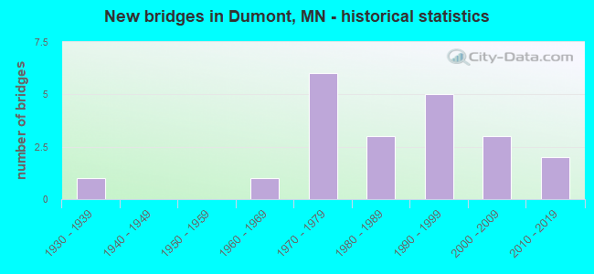
- New bridges - historical statistics
- 11930-1939
- 11960-1969
- 61970-1979
- 31980-1989
- 51990-1999
- 32000-2009
- 22010-2019

- Bridge Condition - Deck
- 75.0%Good
- 25.0%Satisfactory

- Bridge Condition - Superstructure
- 75.0%Good
- 25.0%Satisfactory

- Bridge Condition - Substructure
- 50.0%Very good
- 25.0%Good
- 25.0%Poor

- Bridge Condition - Channel
- 61.9%Very good
- 38.1%Good

- Bridge Condition - Culverts
- 82.4%Good
- 11.8%Satisfactory
- 5.9%Fair
Find on map >> Show street view
Structure Number: 6337, Location: 3.7 MI S OF DUMONT (Lat: 45.664219, Lng: -96.426544), Route carried "on" structure: US 75, Year Built: 1939, Status: Open, Structure Length: 0.80m (2.62ft), Average Daily Traffic: 1,051 (year 2019), Truck Traffic: 10%, Average Future Daily Traffic: 940 (year 2039), Design Load: H 15, Features Intersected: MUSTINKA RIVER
Minimum Vertical Clearance: 30+ m (98+ ft), Kilometerpoint: 0.000, Lanes on structure: 2, Base Highway Network: Yes, Owner: State Highway Agency, Approaching Roadway Width: 12.2m (40.0ft), Material/Design: Concrete, Design/Construction: Culvert, Number Of Spans In Main Unit: 2, Length of Maximum Span: 3.8m (12.5ft)
Condition: Channel: Very good, Culverts: Satisfactory, Operating Rating: 39.2 metric tons, Method Used To Determine Operating Rating: Assigned ratings based on Allowable Stress Design (ASD) reported in metric tons, Inventory Rating: 29.4 metric tons, Method Used To Determine Inventory Rating: Assigned ratings based on Allowable Stress Design (ASD) reported in metric tons, Structural Evaluation: Equal to present minimum criteria, Waterway Adequacy: Equal to present desirable criteria, Approach Roadway Alignment: Equal to present desirable criteria, Length Of Structure Improvement: 0.40m (1.31ft), Designated Inspection Frequency: Every 24 months, Inspection Date: August 2020, Bridge Improvement Cost: $76,000,000, Roadway Improvement Cost: $6,000,000, Total Project Cost: $97,000,000
Find on map >> Show street view
Structure Number: 78516, Location: 1.2 MI E OF JCT CSAH 11 (Lat: 45.744519, Lng: -96.403572), Route carried "on" structure: County highway 70, Year Built: 2004, Status: Open, Structure Length: 2.38m (7.81ft), Average Daily Traffic: 45 (year 2012), Average Future Daily Traffic: 45 (year 2039), Design Load: HL 93, Features Intersected: TWELVE MILE CREEK
Minimum Vertical Clearance: 30+ m (98+ ft), Kilometerpoint: 0.000, Lanes on structure: 2, Owner: County Highway Agency, Approaching Roadway Width: 7.3m (24.0ft), Skew: 1 degrees, Material/Design: Concrete continuous, Design/Construction: Slab, Number Of Spans In Main Unit: 3, Length of Maximum Span: 8.8m (28.9ft), Curb-To-Curb Width: 8.5m (27.9ft), Out-to-Out Width: 9.5m (31.2ft)
Condition: Deck: Good, Superstructure: Good, Substructure: Very good, Channel: Very good, Operating Rating: 72.0 metric tons, Method Used To Determine Operating Rating: Load Factor (LF), Inventory Rating: 43.1 metric tons, Method Used To Determine Inventory Rating: Load Factor (LF), Structural Evaluation: Better than present minimum criteria, Deck Geometry: Better than present minimum criteria, Waterway Adequacy: Superior to present desirable criteria, Approach Roadway Alignment: Equal to present desirable criteria, Length Of Structure Improvement: 0.88m (2.89ft), Designated Inspection Frequency: Every 24 months, Inspection Date: September 2021, Bridge Improvement Cost: $242,000,000, Roadway Improvement Cost: $1,000, Total Project Cost: $1,000, Deck Structure Type: Concrete Cast-file-Place, Wearing Surface/Protective System: Wearing Surface: Monolithic Concrete, Deck Protection: Epoxy Coated Reinforcing
Find on map >> Show street view
Structure Number: 78519, Location: 0.4 MI N OF JCT CSAH 6 (Lat: 45.722325, Lng: -96.357597), Route carried "on" structure: County highway 13, Year Built: 2007, Status: Open, Structure Length: 2.33m (7.64ft), Average Daily Traffic: 20 (year 2012), Average Future Daily Traffic: 20 (year 2039), Design Load: HL 93, Features Intersected: TWELVE MILE CREEK
Minimum Vertical Clearance: 30+ m (98+ ft), Kilometerpoint: 0.000, Lanes on structure: 2, Owner: County Highway Agency, Approaching Roadway Width: 9.8m (32.2ft), Skew: 3 degrees, Material/Design: Concrete continuous, Design/Construction: Slab, Number Of Spans In Main Unit: 3, Length of Maximum Span: 8.6m (28.2ft), Curb-To-Curb Width: 9.8m (32.2ft), Out-to-Out Width: 10.8m (35.4ft)
Condition: Deck: Good, Superstructure: Good, Substructure: Good, Channel: Good, Operating Rating: 71.5 metric tons, Method Used To Determine Operating Rating: Load Factor (LF), Inventory Rating: 42.8 metric tons, Method Used To Determine Inventory Rating: Load Factor (LF), Structural Evaluation: Better than present minimum criteria, Deck Geometry: Equal to present desirable criteria, Waterway Adequacy: Superior to present desirable criteria, Approach Roadway Alignment: Equal to present desirable criteria, Designated Inspection Frequency: Every 24 months, Inspection Date: September 2021, Deck Structure Type: Concrete Cast-file-Place, Wearing Surface/Protective System: Deck Protection: Epoxy Coated Reinforcing
Find on map >> Show street view
Structure Number: 78531, Location: 0.3 MI E OF JCT TH75 (Lat: 45.715681, Lng: -96.422081), Route carried "on" structure: County highway 6, Year Built: 2014, Status: Open, Structure Length: 2.29m (7.51ft), Average Daily Traffic: 275 (year 2016), Average Future Daily Traffic: 275 (year 2039), Design Load: HL 93, Features Intersected: TWELVE MILE CREEK
Minimum Vertical Clearance: 30+ m (98+ ft), Kilometerpoint: 0.000, Lanes on structure: 2, Owner: County Highway Agency, Approaching Roadway Width: 11.0m (36.1ft), Material/Design: Concrete continuous, Design/Construction: Slab, Number Of Spans In Main Unit: 3, Length of Maximum Span: 8.4m (27.6ft), Curb-To-Curb Width: 11.0m (36.1ft), Out-to-Out Width: 12.0m (39.4ft)
Condition: Deck: Good, Superstructure: Good, Substructure: Very good, Channel: Very good, Operating Rating: 46.3 metric tons, Method Used To Determine Operating Rating: Load and Resistance Factor Rating (LRFR) rating reported by rating factor(RF) method using HL-93 loadings, Inventory Rating: 35.6 metric tons, Method Used To Determine Inventory Rating: Load and Resistance Factor Rating (LRFR) rating reported by rating factor(RF) method using HL-93 loadings, Structural Evaluation: Better than present minimum criteria, Deck Geometry: Equal to present desirable criteria, Waterway Adequacy: Superior to present desirable criteria, Approach Roadway Alignment: Equal to present desirable criteria, Designated Inspection Frequency: Every 24 months, Inspection Date: September 2021, Deck Structure Type: Concrete Cast-file-Place, Wearing Surface/Protective System: Wearing Surface: Monolithic Concrete, Deck Protection: Epoxy Coated Reinforcing
Find on map >> Show street view
Structure Number: 78J03, Location: 0.3 MI E OF JCT TH 75 (Lat: 45.686686, Lng: -96.421569), Route carried "on" structure: County highway 62, Year Built: 1999, Status: Open, Structure Length: 0.91m (2.99ft), Average Daily Traffic: 25 (year 2008), Average Future Daily Traffic: 25 (year 2039), Design Load: HS 25 or greater, Features Intersected: W BR TWELVE MILE CREEK
Minimum Vertical Clearance: 30+ m (98+ ft), Kilometerpoint: 0.000, Lanes on structure: 2, Owner: County Highway Agency, Approaching Roadway Width: 8.5m (27.9ft), Material/Design: Concrete, Design/Construction: Culvert, Number Of Spans In Main Unit: 2, Length of Maximum Span: 3.7m (12.1ft)
Condition: Channel: Very good, Culverts: Good, Operating Rating: 68.6 metric tons, Method Used To Determine Operating Rating: Assigned rating based on Load Factor Design (LFD) reported in metric tons, Inventory Rating: 40.8 metric tons, Method Used To Determine Inventory Rating: Assigned rating based on Load Factor Design (LFD) reported in metric tons, Structural Evaluation: Better than present minimum criteria, Waterway Adequacy: Better than present minimum criteria, Approach Roadway Alignment: Equal to present desirable criteria, Designated Inspection Frequency: Every 48 months, Inspection Date: October 2021
Find on map >> Show street view
Structure Number: 78J04, Location: 1.1 MI W OF JCT CSAH 13 (Lat: 45.773342, Lng: -96.382181), Route carried "on" structure: County highway 72, Year Built: 1996, Status: Open, Structure Length: 1.40m (4.59ft), Average Daily Traffic: 25 (year 2016), Average Future Daily Traffic: 25 (year 2039), Design Load: HS 25 or greater, Features Intersected: W BR TWELVE MILE CREEK
Minimum Vertical Clearance: 30+ m (98+ ft), Kilometerpoint: 0.000, Lanes on structure: 2, Owner: County Highway Agency, Approaching Roadway Width: 8.5m (27.9ft), Material/Design: Concrete, Design/Construction: Culvert, Number Of Spans In Main Unit: 3, Length of Maximum Span: 3.7m (12.1ft)
Condition: Channel: Good, Culverts: Good, Operating Rating: 58.8 metric tons, Method Used To Determine Operating Rating: Assigned rating based on Load Factor Design (LFD) reported in metric tons, Inventory Rating: 39.2 metric tons, Method Used To Determine Inventory Rating: Assigned rating based on Load Factor Design (LFD) reported in metric tons, Structural Evaluation: Better than present minimum criteria, Waterway Adequacy: Better than present minimum criteria, Approach Roadway Alignment: Equal to present desirable criteria, Designated Inspection Frequency: Every 48 months, Inspection Date: September 2021
Find on map >> Show street view
Structure Number: 78J07, Location: 0.5 mi S of jct CR 62 (Lat: 45.679558, Lng: -96.385903), Route carried "on" structure: County highway 71, Year Built: 2002, Status: Open, Structure Length: 0.78m (2.56ft), Average Daily Traffic: 50 (year 2012), Average Future Daily Traffic: 50 (year 2039), Design Load: HS 25 or greater, Features Intersected: W Fk of W Br 12mile Crk
Minimum Vertical Clearance: 30+ m (98+ ft), Kilometerpoint: 0.000, Lanes on structure: 2, Owner: County Highway Agency, Approaching Roadway Width: 9.1m (29.9ft), Material/Design: Concrete, Design/Construction: Culvert, Number Of Spans In Main Unit: 2, Length of Maximum Span: 3.0m (9.8ft)
Condition: Channel: Very good, Culverts: Good, Operating Rating: 58.8 metric tons, Method Used To Determine Operating Rating: Assigned rating based on Load Factor Design (LFD) reported in metric tons, Inventory Rating: 39.2 metric tons, Method Used To Determine Inventory Rating: Assigned rating based on Load Factor Design (LFD) reported in metric tons, Structural Evaluation: Better than present minimum criteria, Waterway Adequacy: Better than present minimum criteria, Approach Roadway Alignment: Equal to present desirable criteria, Designated Inspection Frequency: Every 48 months, Inspection Date: October 2021
Find on map >> Show street view
Structure Number: 78J27, Location: 0.4 MI W OF JCT CR71 (Lat: 45.686628, Lng: -96.393792), Route carried "on" structure: County highway 62, Year Built: 2013, Status: Open, Structure Length: 0.79m (2.59ft), Average Daily Traffic: 49 (year 2013), Average Future Daily Traffic: 49 (year 2033), Design Load: HL 93, Features Intersected: STREAM
Minimum Vertical Clearance: 30+ m (98+ ft), Kilometerpoint: 0.000, Lanes on structure: 2, Owner: County Highway Agency, Approaching Roadway Width: 8.5m (27.9ft), Material/Design: Concrete, Design/Construction: Culvert, Number Of Spans In Main Unit: 2, Length of Maximum Span: 3.7m (12.1ft)
Condition: Channel: Very good, Culverts: Good, Operating Rating: 58.8 metric tons, Method Used To Determine Operating Rating: Assigned ratings based on Load and Resistance Factor Design (LRFD) reported in metric tons, Inventory Rating: 39.2 metric tons, Method Used To Determine Inventory Rating: Assigned ratings based on Load and Resistance Factor Design (LRFD) reported in metric tons, Structural Evaluation: Better than present minimum criteria, Waterway Adequacy: Better than present minimum criteria, Approach Roadway Alignment: Equal to present desirable criteria, Designated Inspection Frequency: Every 48 months, Inspection Date: October 2021
Find on map >> Show street view
Structure Number: 91337, Location: 0.1 MI N OF JCT CR 70 (Lat: 45.745861, Lng: -96.357972), Route carried "on" structure: County highway 13, Year Built: 1975, Status: Open, Structure Length: 1.62m (5.31ft), Average Daily Traffic: 20 (year 2012), Average Future Daily Traffic: 20 (year 2039), Design Load: HS 20, Features Intersected: TWELVE MILE CREEK
Minimum Vertical Clearance: 30+ m (98+ ft), Kilometerpoint: 0.000, Lanes on structure: 2, Owner: County Highway Agency, Approaching Roadway Width: 8.5m (27.9ft), Material/Design: Concrete, Design/Construction: Culvert, Number Of Spans In Main Unit: 3, Length of Maximum Span: 4.3m (14.1ft)
Condition: Channel: Very good, Culverts: Good, Operating Rating: 53.9 metric tons, Method Used To Determine Operating Rating: Assigned ratings based on Allowable Stress Design (ASD) reported in metric tons, Inventory Rating: 35.9 metric tons, Method Used To Determine Inventory Rating: Assigned ratings based on Allowable Stress Design (ASD) reported in metric tons, Structural Evaluation: Better than present minimum criteria, Waterway Adequacy: Better than present minimum criteria, Approach Roadway Alignment: Equal to present desirable criteria, Designated Inspection Frequency: Every 24 months, Inspection Date: September 2021
Find on map >> Show street view
Structure Number: 93256, Location: 1.2 MI N OF JCT CSAH 6 (Lat: 45.733178, Lng: -96.357772), Route carried "on" structure: County highway 13, Year Built: 1977, Status: Open, Structure Length: 1.62m (5.31ft), Average Daily Traffic: 20 (year 2012), Average Future Daily Traffic: 20 (year 2039), Design Load: HS 20, Features Intersected: TWELVE MILE CREEK
Minimum Vertical Clearance: 30+ m (98+ ft), Kilometerpoint: 0.000, Lanes on structure: 2, Owner: County Highway Agency, Approaching Roadway Width: 7.6m (24.9ft), Material/Design: Concrete, Design/Construction: Culvert, Number Of Spans In Main Unit: 3, Length of Maximum Span: 4.3m (14.1ft)
Condition: Channel: Good, Culverts: Good, Operating Rating: 53.9 metric tons, Method Used To Determine Operating Rating: Assigned ratings based on Allowable Stress Design (ASD) reported in metric tons, Inventory Rating: 35.9 metric tons, Method Used To Determine Inventory Rating: Assigned ratings based on Allowable Stress Design (ASD) reported in metric tons, Structural Evaluation: Better than present minimum criteria, Waterway Adequacy: Better than present minimum criteria, Approach Roadway Alignment: Equal to present desirable criteria, Designated Inspection Frequency: Every 48 months, Inspection Date: September 2021
Find on map >> Show street view
Structure Number: 96754, Location: 1.2 MI N OF JCT CSAH 6 (Lat: 45.732781, Lng: -96.489639), Route carried "on" structure: County highway 9, Year Built: 1991, Status: Open, Structure Length: 1.62m (5.31ft), Average Daily Traffic: 105 (year 2016), Average Future Daily Traffic: 105 (year 2039), Design Load: HS 20, Features Intersected: STREAM
Minimum Vertical Clearance: 30+ m (98+ ft), Kilometerpoint: 0.000, Lanes on structure: 2, Owner: County Highway Agency, Approaching Roadway Width: 10.4m (34.1ft), Skew: 3 degrees, Material/Design: Concrete, Design/Construction: Culvert, Number Of Spans In Main Unit: 3, Length of Maximum Span: 4.2m (13.8ft)
Condition: Channel: Good, Culverts: Satisfactory, Operating Rating: 58.8 metric tons, Method Used To Determine Operating Rating: Assigned rating based on Load Factor Design (LFD) reported in metric tons, Inventory Rating: 39.2 metric tons, Method Used To Determine Inventory Rating: Assigned rating based on Load Factor Design (LFD) reported in metric tons, Structural Evaluation: Equal to present minimum criteria, Waterway Adequacy: Superior to present desirable criteria, Approach Roadway Alignment: Equal to present desirable criteria, Designated Inspection Frequency: Every 48 months, Inspection Date: October 2021
Find on map >> Show street view
Structure Number: 97119, Location: 0.9 MI E OF JCT TH 75 (Lat: 45.730117, Lng: -96.414367), Route carried "on" structure: County highway 49, Year Built: 1992, Status: Open, Structure Length: 0.78m (2.56ft), Average Daily Traffic: 16 (year 1990), Average Future Daily Traffic: 16 (year 2029), Design Load: HS 25 or greater, Features Intersected: W BR TWELVE MILE CREEK
Minimum Vertical Clearance: 30+ m (98+ ft), Kilometerpoint: 0.000, Lanes on structure: 2, Owner: County Highway Agency, Approaching Roadway Width: 6.7m (22.0ft), Material/Design: Concrete, Design/Construction: Culvert, Number Of Spans In Main Unit: 2, Length of Maximum Span: 3.0m (9.8ft)
Condition: Channel: Good, Culverts: Good, Operating Rating: 58.8 metric tons, Method Used To Determine Operating Rating: Assigned rating based on Load Factor Design (LFD) reported in metric tons, Inventory Rating: 39.2 metric tons, Method Used To Determine Inventory Rating: Assigned rating based on Load Factor Design (LFD) reported in metric tons, Structural Evaluation: Better than present minimum criteria, Waterway Adequacy: Better than present minimum criteria, Approach Roadway Alignment: Equal to present desirable criteria, Designated Inspection Frequency: Every 48 months, Inspection Date: September 2021
Find on map >> Show street view
Structure Number: 97383, Location: 0.1 MI E OF JCT TH 75 (Lat: 45.701225, Lng: -96.424422), Route carried "on" structure: County highway 85, Year Built: 1992, Status: Open, Structure Length: 1.42m (4.66ft), Average Daily Traffic: 10 (year 1990), Average Future Daily Traffic: 10 (year 2029), Design Load: HS 25 or greater, Features Intersected: W BR TWELVE MILE CREEK
Minimum Vertical Clearance: 30+ m (98+ ft), Kilometerpoint: 0.000, Lanes on structure: 2, Owner: County Highway Agency, Approaching Roadway Width: 7.3m (24.0ft), Material/Design: Concrete, Design/Construction: Culvert, Number Of Spans In Main Unit: 3, Length of Maximum Span: 3.7m (12.1ft)
Condition: Channel: Very good, Culverts: Good, Operating Rating: 58.8 metric tons, Method Used To Determine Operating Rating: Assigned rating based on Load Factor Design (LFD) reported in metric tons, Inventory Rating: 39.2 metric tons, Method Used To Determine Inventory Rating: Assigned rating based on Load Factor Design (LFD) reported in metric tons, Structural Evaluation: Better than present minimum criteria, Waterway Adequacy: Better than present minimum criteria, Approach Roadway Alignment: Equal to present desirable criteria, Designated Inspection Frequency: Every 48 months, Inspection Date: October 2021
Find on map >> Show street view
Structure Number: L8966, Location: 0.6 MI W OF JCT TH 75 (Lat: 45.657842, Lng: -96.437828), Route carried "on" structure: County highway 22, Year Built: 1981, Status: Open, Structure Length: 1.02m (3.35ft), Average Daily Traffic: 26 (year 1986), Average Future Daily Traffic: 26 (year 2029), Design Load: HS 20, Features Intersected: W BR TWELVE MILE CREEK
Minimum Vertical Clearance: 30+ m (98+ ft), Kilometerpoint: 0.000, Lanes on structure: 2, Owner: County Highway Agency, Approaching Roadway Width: 7.3m (24.0ft), Material/Design: Concrete, Design/Construction: Culvert, Number Of Spans In Main Unit: 2, Length of Maximum Span: 3.9m (12.8ft)
Condition: Channel: Good, Culverts: Good, Operating Rating: 53.9 metric tons, Method Used To Determine Operating Rating: Assigned ratings based on Allowable Stress Design (ASD) reported in metric tons, Inventory Rating: 35.9 metric tons, Method Used To Determine Inventory Rating: Assigned ratings based on Allowable Stress Design (ASD) reported in metric tons, Structural Evaluation: Better than present minimum criteria, Waterway Adequacy: Better than present minimum criteria, Approach Roadway Alignment: Equal to present desirable criteria, Designated Inspection Frequency: Every 48 months, Inspection Date: October 2021
Find on map >> Show street view
Structure Number: L9132, Location: 0.2 MI W OF JCT CSAH9 (Lat: 45.730433, Lng: -96.492347), Route carried "on" structure: County highway 49, Year Built: 1969, Status: Open, Structure Length: 0.67m (2.20ft), Average Daily Traffic: 10 (year 1986), Average Future Daily Traffic: 10 (year 2029), Features Intersected: STREAM
Minimum Vertical Clearance: 30+ m (98+ ft), Kilometerpoint: 0.000, Lanes on structure: 2, Owner: County Highway Agency, Approaching Roadway Width: 6.4m (21.0ft), Material/Design: Wood or Timber, Design/Construction: Slab, Number Of Spans In Main Unit: 1, Length of Maximum Span: 6.1m (20.0ft), Curb-To-Curb Width: 6.2m (20.3ft), Out-to-Out Width: 6.5m (21.3ft)
Condition: Deck: Satisfactory, Superstructure: Satisfactory, Substructure: Poor, Channel: Good, Operating Rating: 45.7 metric tons, Method Used To Determine Operating Rating: Allowable Stress (AS), Inventory Rating: 32.7 metric tons, Method Used To Determine Inventory Rating: Allowable Stress (AS), Structural Evaluation: Meets minimum limits, Deck Geometry: Somewhat better than minimum adequacy, Waterway Adequacy: Equal to present desirable criteria, Approach Roadway Alignment: Equal to present desirable criteria, Length Of Structure Improvement: 1.10m (3.61ft), Designated Inspection Frequency: Every 12 months, Inspection Date: October 2021, Bridge Improvement Cost: $131,000,000, Roadway Improvement Cost: $14,000,000, Total Project Cost: $145,000,000 ( Estimate for 2019), Deck Structure Type: Wood or Timber, Wearing Surface/Protective System: Wearing Surface: Gravel
Find on map >> Show street view
Structure Number: L97, Location: 0.1 MI E OF JCT TH 75 (Lat: 45.672250, Lng: -96.425606), Route carried "on" structure: County highway 25, Year Built: 1977, Status: Open, Structure Length: 1.12m (3.67ft), Average Daily Traffic: 6 (year 1986), Average Future Daily Traffic: 6 (year 2029), Design Load: HS 20, Features Intersected: W BR TWELVE MILE CREEK
Minimum Vertical Clearance: 30+ m (98+ ft), Kilometerpoint: 0.000, Lanes on structure: 2, Owner: County Highway Agency, Approaching Roadway Width: 7.6m (24.9ft), Material/Design: Concrete, Design/Construction: Culvert, Number Of Spans In Main Unit: 3, Length of Maximum Span: 3.1m (10.2ft)
Condition: Channel: Very good, Culverts: Good, Operating Rating: 53.9 metric tons, Method Used To Determine Operating Rating: Assigned ratings based on Allowable Stress Design (ASD) reported in metric tons, Inventory Rating: 35.9 metric tons, Method Used To Determine Inventory Rating: Assigned ratings based on Allowable Stress Design (ASD) reported in metric tons, Structural Evaluation: Better than present minimum criteria, Waterway Adequacy: Better than present minimum criteria, Approach Roadway Alignment: Equal to present desirable criteria, Designated Inspection Frequency: Every 24 months, Inspection Date: October 2021
Find on map >> Show street view
Structure Number: L978, Location: 0.4 MI W OF JCT CSAH 13 (Lat: 45.759103, Lng: -96.366119), Route carried "on" structure: County highway 76, Year Built: 1978, Status: Open, Structure Length: 1.47m (4.82ft), Average Daily Traffic: 4 (year 1986), Average Future Daily Traffic: 4 (year 2029), Design Load: HS 20, Features Intersected: TWELVE MILE CREEK
Minimum Vertical Clearance: 30+ m (98+ ft), Kilometerpoint: 0.000, Lanes on structure: 2, Owner: County Highway Agency, Approaching Roadway Width: 7.3m (24.0ft), Material/Design: Concrete, Design/Construction: Culvert, Number Of Spans In Main Unit: 3, Length of Maximum Span: 4.3m (14.1ft)
Condition: Channel: Good, Culverts: Fair, Operating Rating: 53.9 metric tons, Method Used To Determine Operating Rating: Assigned ratings based on Allowable Stress Design (ASD) reported in metric tons, Inventory Rating: 35.9 metric tons, Method Used To Determine Inventory Rating: Assigned ratings based on Allowable Stress Design (ASD) reported in metric tons, Structural Evaluation: Somewhat better than minimum adequacy, Waterway Adequacy: Better than present minimum criteria, Approach Roadway Alignment: Equal to present desirable criteria, Length Of Structure Improvement: 0.64m (2.10ft), Designated Inspection Frequency: Every 24 months, Inspection Date: September 2021, Bridge Improvement Cost: $142,000,000, Total Project Cost: $104,000,000
Find on map >> Show street view
Structure Number: L9781, Location: 0.1 MI W OF JCT CSAH 13 (Lat: 45.730664, Lng: -96.359108), Route carried "on" structure: County highway 49, Year Built: 1978, Status: Open, Structure Length: 1.47m (4.82ft), Average Daily Traffic: 4 (year 1986), Average Future Daily Traffic: 4 (year 2029), Design Load: HS 20, Features Intersected: TWELVE MILE CREEK
Minimum Vertical Clearance: 30+ m (98+ ft), Kilometerpoint: 0.000, Lanes on structure: 2, Owner: County Highway Agency, Approaching Roadway Width: 7.0m (23.0ft), Material/Design: Concrete, Design/Construction: Culvert, Number Of Spans In Main Unit: 3, Length of Maximum Span: 4.3m (14.1ft)
Condition: Channel: Very good, Culverts: Good, Operating Rating: 53.9 metric tons, Method Used To Determine Operating Rating: Assigned ratings based on Allowable Stress Design (ASD) reported in metric tons, Inventory Rating: 35.9 metric tons, Method Used To Determine Inventory Rating: Assigned ratings based on Allowable Stress Design (ASD) reported in metric tons, Structural Evaluation: Better than present minimum criteria, Waterway Adequacy: Better than present minimum criteria, Approach Roadway Alignment: Equal to present desirable criteria, Designated Inspection Frequency: Every 48 months, Inspection Date: September 2021
Find on map >> Show street view
Structure Number: L9835, Location: 1.4 MI W OF JCT CSAH 13 (Lat: 45.758942, Lng: -96.387725), Route carried "on" structure: County highway 76, Year Built: 1978, Status: Open, Structure Length: 1.47m (4.82ft), Average Daily Traffic: 10 (year 1986), Average Future Daily Traffic: 10 (year 2029), Design Load: HS 20, Features Intersected: W BR TWELVE MILE CREEK
Minimum Vertical Clearance: 30+ m (98+ ft), Kilometerpoint: 0.000, Lanes on structure: 2, Owner: County Highway Agency, Approaching Roadway Width: 7.3m (24.0ft), Material/Design: Concrete, Design/Construction: Culvert, Number Of Spans In Main Unit: 3, Length of Maximum Span: 4.3m (14.1ft)
Condition: Channel: Very good, Culverts: Good, Operating Rating: 53.9 metric tons, Method Used To Determine Operating Rating: Assigned ratings based on Allowable Stress Design (ASD) reported in metric tons, Inventory Rating: 35.9 metric tons, Method Used To Determine Inventory Rating: Assigned ratings based on Allowable Stress Design (ASD) reported in metric tons, Structural Evaluation: Better than present minimum criteria, Waterway Adequacy: Better than present minimum criteria, Approach Roadway Alignment: Equal to present desirable criteria, Designated Inspection Frequency: Every 24 months, Inspection Date: September 2021
Find on map >> Show street view
Structure Number: R0001, Location: 0.5 MI S OF JCT CR 72 (Lat: 45.766839, Lng: -96.386147), Route carried "on" structure: County highway 82, Year Built: 1980, Status: Open, Structure Length: 1.62m (5.31ft), Average Daily Traffic: 16 (year 1986), Average Future Daily Traffic: 16 (year 2029), Design Load: HS 20, Features Intersected: W BR TWELVE MILE CREEK
Minimum Vertical Clearance: 30+ m (98+ ft), Kilometerpoint: 0.000, Lanes on structure: 2, Owner: County Highway Agency, Approaching Roadway Width: 7.3m (24.0ft), Material/Design: Concrete, Design/Construction: Culvert, Number Of Spans In Main Unit: 3, Length of Maximum Span: 4.3m (14.1ft)
Condition: Channel: Very good, Culverts: Good, Operating Rating: 53.9 metric tons, Method Used To Determine Operating Rating: Assigned ratings based on Allowable Stress Design (ASD) reported in metric tons, Inventory Rating: 35.9 metric tons, Method Used To Determine Inventory Rating: Assigned ratings based on Allowable Stress Design (ASD) reported in metric tons, Structural Evaluation: Better than present minimum criteria, Waterway Adequacy: Better than present minimum criteria, Approach Roadway Alignment: Equal to present desirable criteria, Designated Inspection Frequency: Every 24 months, Inspection Date: September 2021
Find on map >> Show street view
Structure Number: R0046, Location: 0.8 MI N OF JCT CR 62 (Lat: 45.697094, Lng: -96.406686), Route carried "on" structure: County highway 70, Year Built: 1983, Status: Open, Structure Length: 1.04m (3.41ft), Average Daily Traffic: 18 (year 1986), Average Future Daily Traffic: 18 (year 2029), Design Load: HS 20, Features Intersected: STREAM
Minimum Vertical Clearance: 30+ m (98+ ft), Kilometerpoint: 0.000, Lanes on structure: 2, Owner: County Highway Agency, Approaching Roadway Width: 7.3m (24.0ft), Skew: 3 degrees, Material/Design: Concrete, Design/Construction: Culvert, Number Of Spans In Main Unit: 2, Length of Maximum Span: 4.5m (14.8ft)
Condition: Channel: Very good, Culverts: Good, Operating Rating: 53.9 metric tons, Method Used To Determine Operating Rating: Assigned ratings based on Allowable Stress Design (ASD) reported in metric tons, Inventory Rating: 35.9 metric tons, Method Used To Determine Inventory Rating: Assigned ratings based on Allowable Stress Design (ASD) reported in metric tons, Structural Evaluation: Better than present minimum criteria, Waterway Adequacy: Equal to present desirable criteria, Approach Roadway Alignment: Equal to present desirable criteria, Designated Inspection Frequency: Every 24 months, Inspection Date: October 2021