Bridge Statistics for Dunbar, West Virginia (WV)
Condition, Traffic, Stress, Structural Evaluation, Project Costs
- National Bridge Inventory (NBI) Statistics
- 11Number of bridges
- 354ft / 108mTotal length
- $625,000Total costs
- 335,455Total average daily traffic
- 63,718Total average daily truck traffic
- National Bridge Inventory (NBI) Registered Bridges for Dunbar
- No street view available for this location
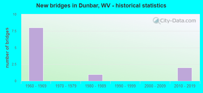
- New bridges - historical statistics
- 81960-1969
- 11980-1989
- 22010-2019

- Reconstructed bridges - Historical Statistics
- 11990-1999
- 12000-2009


- Bridge Condition - Deck
- 40.0%Good
- 40.0%Satisfactory
- 20.0%Fair

- Bridge Condition - Superstructure
- 40.0%Good
- 60.0%Satisfactory

- Bridge Condition - Substructure
- 60.0%Good
- 40.0%Satisfactory

- Bridge Condition - Channel
- 33.3%Excellent
- 33.3%Good
- 33.3%Satisfactory
Find on map >> Show street view
Structure Number: 20A008, Location: 0.05 MI N OF WV 62 (Lat: 38.382539, Lng: -81.713461), Route carried "on" structure: County highway 56, Year Built: 1988, Status: Open, Structure Length: 0.84m (2.76ft), Average Daily Traffic: 2,300 (year 2018), Truck Traffic: 5%, Average Future Daily Traffic: 2,806 (year 2038), Design Load: HS 20, Features Intersected: LANDERS CREEK, Facility Carried by Structure: COUNTY ROUTE 5/6
Minimum Vertical Clearance: 30+ m (98+ ft), Kilometerpoint: 0.080, Lanes on structure: 2, Owner: State Highway Agency, Approaching Roadway Width: 4.9m (16.1ft), Skew: 3 degrees, Material/Design: Prestressed concrete, Design/Construction: Slab, Number Of Spans In Main Unit: 1, Length of Maximum Span: 7.9m (25.9ft), Curb-To-Curb Width: 5.9m (19.4ft), Out-to-Out Width: 6.1m (20.0ft)
Condition: Deck: Satisfactory, Superstructure: Satisfactory, Substructure: Good, Channel: Satisfactory, Operating Rating: 83.4 metric tons, Method Used To Determine Operating Rating: Load Factor (LF), Inventory Rating: 49.9 metric tons, Method Used To Determine Inventory Rating: Load Factor (LF), Structural Evaluation: Equal to present minimum criteria, Deck Geometry: High priority of replacement, Waterway Adequacy: Equal to present minimum criteria, Approach Roadway Alignment: Equal to present desirable criteria, Length Of Structure Improvement: 0.84m (2.76ft), Designated Inspection Frequency: Every 24 months, Inspection Date: September 2020, Bridge Improvement Cost: $125,000, Roadway Improvement Cost: $25,000, Total Project Cost: $150,000 ( Estimate for 2020), Deck Structure Type: Other, Wearing Surface/Protective System: Wearing Surface: Bituminous
Find on map >> Show street view
Structure Number: 20A382, Location: 1.62 MI E OF WV 25 (Lat: 38.373369, Lng: -81.750361), Route carried "on" structure: Interstate 64, Year Built: 1966, Status: Open, Structure Length: 0.85m (2.79ft), Average Daily Traffic: 56,000 (year 2020), Truck Traffic: 17%, Average Future Daily Traffic: 87,360 (year 2040), Design Load: HS 20+Mod, Features Intersected: CR25/18
Minimum Vertical Clearance: 30+ m (98+ ft), Kilometerpoint: 83.042, Lanes on structure: 4, Lanes under structure: 2, Base Highway Network: Yes, Owner: State Highway Agency, Approaching Roadway Width: 33.2m (108.9ft), Skew: 30 degrees, Material/Design: Concrete, Design/Construction: Culvert, Number Of Spans In Main Unit: 1, Length of Maximum Span: 8.5m (27.9ft)
Condition: Culverts: Fair, Operating Rating: 63.5 metric tons, Method Used To Determine Operating Rating: Field evaluation and documented engineering judgment, Inventory Rating: 29.0 metric tons, Method Used To Determine Inventory Rating: Field evaluation and documented engineering judgment, Structural Evaluation: Somewhat better than minimum adequacy, Underclear: High priority of corrective action, Approach Roadway Alignment: Equal to present desirable criteria, Length Of Structure Improvement: 0.85m (2.79ft), Designated Inspection Frequency: Every 24 months, Inspection Date: June 2021, Bridge Improvement Cost: $150,000, Roadway Improvement Cost: $25,000, Total Project Cost: $175,000 ( Estimate for 2019)
Find on map >> Show street view
Structure Number: 20A783, Location: 1.00 MILE EAST OF WV 25 (Lat: 38.377269, Lng: -81.755069), Route carried "on" structure: Interstate 6400, Year Built: 1966, Status: Open, Structure Length: 7.23m (23.72ft), Average Daily Traffic: 68,700 (year 2018), Truck Traffic: 17%, Average Future Daily Traffic: 83,814 (year 2038), Design Load: HS 25 or greater, Features Intersected: CR 25/3, Facility Carried by Structure: I-64 EBL &WBL
Minimum Vertical Clearance: 30+ m (98+ ft), Kilometerpoint: 82.044, Lanes on structure: 6, Lanes under structure: 2, Base Highway Network: Yes, Owner: State Highway Agency, Approaching Roadway Width: 33.5m (109.9ft), Skew: 30 degrees, Material/Design: Steel continuous, Design/Construction: Stringer/Multi-beam, Number Of Spans In Main Unit: 1, Number Of Approach Spans: 2, Length of Maximum Span: 31.4m (103.0ft), Curb-To-Curb Width: 33.5m (109.9ft), Out-to-Out Width: 34.9m (114.5ft)
Condition: Deck: Fair, Superstructure: Good, Substructure: Satisfactory, Channel: Good, Operating Rating: 53.5 metric tons, Method Used To Determine Operating Rating: Load and Resistance Factor (LRFR), Inventory Rating: 41.7 metric tons, Method Used To Determine Inventory Rating: Load and Resistance Factor (LRFR), Structural Evaluation: Equal to present minimum criteria, Deck Geometry: Superior to present desirable criteria, Underclear: Superior to present desirable criteria, Waterway Adequacy: Superior to present desirable criteria, Approach Roadway Alignment: Equal to present desirable criteria, Length Of Structure Improvement: 7.23m (23.72ft), Designated Inspection Frequency: Every 24 months, Inspection Date: March 2021, Bridge Improvement Cost: $250,000, Roadway Improvement Cost: $50,000, Total Project Cost: $300,000 ( Estimate for 2021), Deck Structure Type: Concrete Cast-file-Place, Wearing Surface/Protective System: Wearing Surface: Monolithic Concrete, Deck Protection: Epoxy Coated Reinforcing
Find on map >> Show street view
Structure Number: 20A785, Location: 1.84 MILE E. OF WV 25 (Lat: 38.368581, Lng: -81.744561), Route carried "on" structure: Interstate 64, Year Built: 1966, Year Reconstructed: 2000, Status: Open, Structure Length: 3.12m (10.24ft), Average Daily Traffic: 56,000 (year 2020), Truck Traffic: 21%, Average Future Daily Traffic: 68,320 (year 2040), Design Load: HS 25 or greater, Features Intersected: CR 25/5 VALLEY DRIVE
Minimum Vertical Clearance: 30+ m (98+ ft), Kilometerpoint: 83.396, Lanes on structure: 6, Lanes under structure: 2, Base Highway Network: Yes, Owner: State Highway Agency, Approaching Roadway Width: 16.8m (55.1ft), Skew: 10 degrees, Material/Design: Steel continuous, Design/Construction: Stringer/Multi-beam, Number Of Spans In Main Unit: 1, Number Of Approach Spans: 2, Length of Maximum Span: 11.6m (38.1ft), Curb-To-Curb Width: 33.5m (109.9ft), Out-to-Out Width: 34.9m (114.5ft)
Condition: Deck: Satisfactory, Superstructure: Satisfactory, Substructure: Satisfactory, Operating Rating: 61.7 metric tons, Method Used To Determine Operating Rating: Load Factor (LF), Inventory Rating: 37.2 metric tons, Method Used To Determine Inventory Rating: Load Factor (LF), Structural Evaluation: Equal to present minimum criteria, Deck Geometry: Superior to present desirable criteria, Underclear: Meets minimum limits, Approach Roadway Alignment: Equal to present desirable criteria, Designated Inspection Frequency: Every 24 months, Inspection Date: May 2021, Deck Structure Type: Concrete Cast-file-Place, Wearing Surface/Protective System: Wearing Surface: Monolithic Concrete, Deck Protection: Epoxy Coated Reinforcing
Find on map >> Show street view
Structure Number: 20A803, Location: 2.40 MILE E OF WV 25 (Lat: 38.362650, Lng: -81.737389), Route carried "on" structure: Interstate 6400, Year Built: 1966, Year Reconstructed: 2002, Status: Open, Structure Length: 5.20m (17.06ft), Average Daily Traffic: 65,100 (year 2019), Truck Traffic: 21%, Average Future Daily Traffic: 91,791 (year 2039), Design Load: HL 93, Features Intersected: CR 25/25 10TH ST.DUNBAR, Facility Carried by Structure: I-64
Minimum Vertical Clearance: 30+ m (98+ ft), Kilometerpoint: 84.297, Lanes on structure: 6, Lanes under structure: 3, Base Highway Network: Yes, Owner: State Highway Agency, Approaching Roadway Width: 19.2m (63.0ft), Skew: 33 degrees, Material/Design: Steel continuous, Design/Construction: Stringer/Multi-beam, Number Of Spans In Main Unit: 1, Number Of Approach Spans: 2, Length of Maximum Span: 27.0m (88.6ft), Curb-To-Curb Width: 39.2m (128.6ft), Out-to-Out Width: 39.7m (130.2ft)
Condition: Deck: Good, Superstructure: Good, Substructure: Good, Operating Rating: 38.1 metric tons, Method Used To Determine Operating Rating: Load and Resistance Factor (LRFR), Inventory Rating: 29.0 metric tons, Method Used To Determine Inventory Rating: Load and Resistance Factor (LRFR), Structural Evaluation: Better than present minimum criteria, Deck Geometry: Superior to present desirable criteria, Underclear: High priority of corrective action, Approach Roadway Alignment: Equal to present desirable criteria, Designated Inspection Frequency: Every 24 months, Inspection Date: December 2020, Deck Structure Type: Concrete Cast-file-Place, Wearing Surface/Protective System: Wearing Surface: Monolithic Concrete, Deck Protection: Epoxy Coated Reinforcing
Find on map >> Show street view
Structure Number: 20A842, Location: 0.75 Mi E of I-64 Exit 53 (Lat: 38.361039, Lng: -81.719361), Route carried "on" structure: Interstate 640, Year Built: 2010, Status: Open, Structure Length: 90.69m (297.54ft), Average Daily Traffic: 78,553 (year 2017), Truck Traffic: 21%, Average Future Daily Traffic: 47,275 (year 2038), Design Load: HL 93, Features Intersected: WV25,US60,KANAWHA RV,CSX, Facility Carried by Structure: I-64 EB
Minimum Vertical Clearance: 5.18m (16.99ft), Kilometerpoint: 85.327, Lanes on structure: 4, Lanes under structure: 10, Base Highway Network: Yes, Owner: State Highway Agency, Approaching Roadway Width: 19.5m (64.0ft), Skew: 9 degrees, Material/Design: Prestressed concrete continuous, Design/Construction: Segmental Box Girder, Number Of Spans In Main Unit: 8, Length of Maximum Span: 231.6m (759.8ft), Curb-To-Curb Width: 19.5m (64.0ft), Out-to-Out Width: 20.4m (66.9ft)
Condition: Deck: Good, Superstructure: Satisfactory, Substructure: Good, Channel: Excellent, Operating Rating: 48.1 metric tons, Method Used To Determine Operating Rating: Load and Resistance Factor (LRFR), Inventory Rating: 37.2 metric tons, Method Used To Determine Inventory Rating: Load and Resistance Factor (LRFR), Structural Evaluation: Equal to present minimum criteria, Deck Geometry: Somewhat better than minimum adequacy, Underclear: Superior to present desirable criteria, Waterway Adequacy: Superior to present desirable criteria, Approach Roadway Alignment: Superior to present desirable criteria, Designated Inspection Frequency: Every 24 months, Inspection Date: May 2021, Deck Structure Type: Concrete Cast-file-Place, Wearing Surface/Protective System: Wearing Surface: Latex Concrete, Membrane: Built-up, Deck Protection: Epoxy Coated Reinforcing
Find on map >> Show street view
Structure Number: 20A382, Location: 1.62 MI E OF WV 25 (Lat: 38.222000, Lng: -81.451000), Route carried "under" structure: County highway 2518, Year Built: 1966, Structure Length: 0. m, Average Daily Traffic: 500 (year 0013), Truck Traffic: 8%, Features Intersected: CR25/18, Facility Carried by Structure: I-64 EBL & WBL.
Minimum Vertical Clearance: 4.34m (14.24ft), Kilometerpoint: 0.451, Lanes on structure: 4, Lanes under structure: 2, Length of Maximum Span: 8.5m (27.9ft)
Find on map >> Show street view
Structure Number: 20A783, Location: 1.00 MILE EAST OF WV 25 (Lat: 38.377200, Lng: -81.755000), Route carried "under" structure: County highway 2503, Year Built: 1966, Structure Length: 0. m, Average Daily Traffic: 10 (year 0007), Features Intersected: CR 25/3, Facility Carried by Structure: I-64 EBL &WBL
Minimum Vertical Clearance: 8.56m (28.08ft), Kilometerpoint: 0.048, Lanes on structure: 6, Lanes under structure: 2, Length of Maximum Span: 31.4m (103.0ft)
Find on map >> Show street view
Structure Number: 20A785, Location: 1.84 MILE E. OF WV 25 (Lat: 38.368581, Lng: -81.744561), Route carried "under" structure: County highway 2505, Year Built: 1966, Structure Length: 0. m, Average Daily Traffic: 794 (year 0017), Truck Traffic: 8%, Features Intersected: CR 25/5 VALLEY DRIVE, Facility Carried by Structure: I-64 EBL'S & WBL'S
Minimum Vertical Clearance: 4.39m (14.40ft), Kilometerpoint: 0.016, Lanes on structure: 6, Lanes under structure: 2, Length of Maximum Span: 11.6m (38.1ft)
Find on map >> Show street view
Structure Number: 20A803, Location: 2.40 MILE E OF WV 25 (Lat: 38.362000, Lng: -81.737000), Route carried "under" structure: County highway 2525, Year Built: 1966, Structure Length: 0. m, Average Daily Traffic: 7,498 (year 0015), Truck Traffic: 5%, Features Intersected: CR 25/25 10TH ST.DUNBAR, Facility Carried by Structure: I-64
Minimum Vertical Clearance: 4.85m (15.91ft), Kilometerpoint: 0.161, Lanes on structure: 6, Lanes under structure: 3, Length of Maximum Span: 27.0m (88.6ft)
Find on map >> Show street view
Structure Number: 20A842, Location: 0.75 Mi E of I-64 Exit 53 (Lat: 38.361039, Lng: -81.719361), Route carried "under" structure: State highway 25, Year Built: 2010, Structure Length: 0. m, Features Intersected: WV25,US60,KANAWHA RV,CSX, Facility Carried by Structure: I-64 EB
Minimum Vertical Clearance: 21.69m (71.16ft), Kilometerpoint: 15.015, Lanes on structure: 4, Lanes under structure: 2, Length of Maximum Span: 231.6m (759.8ft)