Bridge Statistics for East Berlin, Pennsylvania (PA)
Condition, Traffic, Stress, Structural Evaluation, Project Costs
- National Bridge Inventory (NBI) Statistics
- 17Number of bridges
- 151ft / 45.9mTotal length
- $732,000Total costs
- 34,906Total average daily traffic
- 3,081Total average daily truck traffic
- 45,573Total future (year 2006) average daily traffic
- National Bridge Inventory (NBI) Registered Bridges for East Berlin
- No street view available for this location
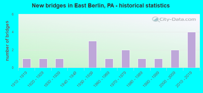
- New bridges - historical statistics
- 11910-1919
- 11920-1929
- 11930-1939
- 31950-1959
- 11960-1969
- 21970-1979
- 11980-1989
- 11990-1999
- 22000-2009
- 42010-2019

- Reconstructed bridges - Historical Statistics
- 11970-1979
- 01980-1989
- 01990-1999
- 12000-2009
- 12010-2019


- Bridge Condition - Deck
- 9.1%Very good
- 54.5%Good
- 27.3%Satisfactory
- 9.1%Poor

- Bridge Condition - Superstructure
- 15.4%Very good
- 30.8%Good
- 7.7%Satisfactory
- 15.4%Fair
- 30.8%Poor

- Bridge Condition - Substructure
- 7.7%Very good
- 30.8%Good
- 30.8%Satisfactory
- 30.8%Fair

- Bridge Condition - Channel
- 11.8%Very good
- 23.5%Good
- 23.5%Satisfactory
- 41.2%Fair

- Bridge Condition - Culverts
- 50.0%Very good
- 25.0%Good
- 25.0%Fair
Find on map >> Show street view
Structure Number: 157, Location: EAST BERLIN BORO (Lat: 39.940883, Lng: -76.990628), Route carried "on" structure: State highway 234, Year Built: 1993, Status: Open, Structure Length: 6.86m (22.51ft), Average Daily Traffic: 7,512 (year 2020), Truck Traffic: 7%, Average Future Daily Traffic: 10,435 (year 2032), Design Load: HS 25 or greater, Features Intersected: CONEWAGO CREEK
Minimum Vertical Clearance: 30+ m (98+ ft), Kilometerpoint: 42.236, Lanes on structure: 2, Base Highway Network: Yes, Owner: State Highway Agency, Approaching Roadway Width: 10.4m (34.1ft), Material/Design: Prestressed concrete, Design/Construction: Box Beam or Girders - Single/Spread, Number Of Spans In Main Unit: 3, Length of Maximum Span: 22.3m (73.2ft), Curb or Sidewalk Widths: Left: 0.2m (0.7ft), Right: 0.2m (0.7ft), Curb-To-Curb Width: 10.4m (34.1ft), Out-to-Out Width: 11.4m (37.4ft)
Condition: Deck: Good, Superstructure: Good, Substructure: Good, Channel: Satisfactory, Inventory Rating: 46.3 metric tons, Method Used To Determine Inventory Rating: Load Factor (LF), Structural Evaluation: Better than present minimum criteria, Deck Geometry: Meets minimum limits, Waterway Adequacy: Superior to present desirable criteria, Approach Roadway Alignment: Equal to present desirable criteria, Length Of Structure Improvement: 7.90m (25.92ft), Designated Inspection Frequency: Every 48 months, Inspection Date: June 2019, Deck Structure Type: Concrete Cast-file-Place, Wearing Surface/Protective System: Wearing Surface: Monolithic Concrete, Deck Protection: Epoxy Coated Reinforcing
Find on map >> Show street view
Structure Number: 432, Location: 1 SE BERLIN/BEAVER CREEK (Lat: 39.917417, Lng: -76.967331), Route carried "on" structure: City street , Year Built: 1954, Year Reconstructed: 1984, Status: Open, Structure Length: 1.62m (5.31ft), Average Daily Traffic: 75 (year 2009), Truck Traffic: 3%, Average Future Daily Traffic: 105 (year 2030), Features Intersected: BEAVER CREEK, Facility Carried by Structure: JACOBS MILL ROAD
Minimum Vertical Clearance: 30+ m (98+ ft), Kilometerpoint: 0.000, Lanes on structure: 1, Owner: County Highway Agency, Approaching Roadway Width: 5.5m (18.0ft), Material/Design: Prestressed concrete, Design/Construction: Box Beam or Girders - Multiple, Number Of Spans In Main Unit: 1, Length of Maximum Span: 15.5m (50.9ft), Curb or Sidewalk Widths: Left: 0.2m (0.7ft), Right: 0.2m (0.7ft), Curb-To-Curb Width: 5.1m (16.7ft), Out-to-Out Width: 5.5m (18.0ft)
Condition: Deck: Satisfactory, Superstructure: Fair, Substructure: Fair, Channel: Fair, Operating Rating: 93.4 metric tons, Method Used To Determine Operating Rating: Load Factor (LF), Inventory Rating: 50.8 metric tons, Method Used To Determine Inventory Rating: Load Factor (LF), Structural Evaluation: Somewhat better than minimum adequacy, Deck Geometry: High priority of corrective action, Waterway Adequacy: Equal to present minimum criteria, Approach Roadway Alignment: Somewhat better than minimum adequacy, Length Of Structure Improvement: 1.60m (5.25ft), Designated Inspection Frequency: Every 24 months, Inspection Date: August 2021, Bridge Improvement Cost: $3,000, Roadway Improvement Cost: $12,000, Total Project Cost: $44,000, Deck Structure Type: Concrete Cast-file-Place, Wearing Surface/Protective System: Wearing Surface: Monolithic Concrete
Find on map >> Show street view
Structure Number: 466, Location: 2 SW E.BERLIN/MARKLE RUN (Lat: 39.930664, Lng: -77.016425), Route carried "on" structure: City street , Year Built: 1970, Status: Open, Structure Length: 1.52m (4.99ft), Average Daily Traffic: 100 (year 2009), Truck Traffic: 5%, Average Future Daily Traffic: 140 (year 2030), Design Load: HS 20, Features Intersected: MARKLE RUN, Facility Carried by Structure: MARKLE RUN ROAD
Minimum Vertical Clearance: 30+ m (98+ ft), Kilometerpoint: 0.000, Lanes on structure: 2, Owner: County Highway Agency, Approaching Roadway Width: 6.7m (22.0ft), Skew: 3 degrees, Material/Design: Concrete, Design/Construction: Slab, Number Of Spans In Main Unit: 2, Length of Maximum Span: 7.3m (24.0ft), Curb or Sidewalk Widths: Left: 0.2m (0.7ft), Right: 0.2m (0.7ft), Curb-To-Curb Width: 8.5m (27.9ft), Out-to-Out Width: 9.8m (32.2ft)
Condition: Deck: Good, Superstructure: Satisfactory, Substructure: Satisfactory, Channel: Fair, Operating Rating: 59.9 metric tons, Method Used To Determine Operating Rating: Load Factor (LF), Inventory Rating: 36.3 metric tons, Method Used To Determine Inventory Rating: Load Factor (LF), Structural Evaluation: Equal to present minimum criteria, Deck Geometry: Better than present minimum criteria, Waterway Adequacy: Better than present minimum criteria, Approach Roadway Alignment: Equal to present desirable criteria, Length Of Structure Improvement: 1.50m (4.92ft), Designated Inspection Frequency: Every 24 months, Inspection Date: August 2021, Wearing Surface/Protective System: Wearing Surface: Monolithic Concrete
Find on map >> Show street view
Structure Number: 37948, Location: 2 MILE W. FARMERS (Lat: 39.914672, Lng: -76.959539), Route carried "on" structure: State highway , Year Built: 1938, Year Reconstructed: 2015, Status: Open, Structure Length: 0.70m (2.30ft), Average Daily Traffic: 1,542 (year 2022), Truck Traffic: 4%, Average Future Daily Traffic: 1,633 (year 2032), Design Load: HS 20, Features Intersected: TRIB TO BEAVER CREEK, Facility Carried by Structure: SR 4002
Minimum Vertical Clearance: 30+ m (98+ ft), Kilometerpoint: 3.344, Lanes on structure: 2, Owner: State Highway Agency, Approaching Roadway Width: 6.1m (20.0ft), Skew: 1 degrees, Material/Design: Concrete, Design/Construction: Slab, Number Of Spans In Main Unit: 1, Length of Maximum Span: 6.7m (22.0ft), Curb-To-Curb Width: 6.7m (22.0ft), Out-to-Out Width: 7.3m (24.0ft)
Condition: Deck: Very good, Superstructure: Very good, Substructure: Fair, Channel: Satisfactory, Operating Rating: 77.1 metric tons, Method Used To Determine Operating Rating: Load Factor (LF), Inventory Rating: 46.3 metric tons, Method Used To Determine Inventory Rating: Load Factor (LF), Structural Evaluation: Somewhat better than minimum adequacy, Deck Geometry: High priority of corrective action, Waterway Adequacy: Equal to present minimum criteria, Approach Roadway Alignment: Equal to present desirable criteria, Length Of Structure Improvement: 1.30m (4.27ft), Designated Inspection Frequency: Every 24 months, Inspection Date: September 2021, Deck Structure Type: Concrete Cast-file-Place, Wearing Surface/Protective System: Wearing Surface: Monolithic Concrete, Membrane: Epoxy, Deck Protection: Epoxy Coated Reinforcing
Find on map >> Show street view
Structure Number: 37966, Location: 4.5 MI W DAVIDSBURG (Lat: 39.992417, Lng: -76.960347), Route carried "on" structure: State highway , Year Built: 1966, Year Reconstructed: 2011, Status: Open, Structure Length: 1.31m (4.30ft), Average Daily Traffic: 1,714 (year 2022), Truck Traffic: 8%, Average Future Daily Traffic: 1,931 (year 2032), Design Load: H 20, Features Intersected: RED RUN, Facility Carried by Structure: SR 4008
Minimum Vertical Clearance: 30+ m (98+ ft), Kilometerpoint: 2.589, Lanes on structure: 2, Owner: State Highway Agency, Approaching Roadway Width: 7.9m (25.9ft), Skew: 3 degrees, Material/Design: Prestressed concrete, Design/Construction: Box Beam or Girders - Single/Spread, Number Of Spans In Main Unit: 1, Length of Maximum Span: 12.8m (42.0ft), Curb-To-Curb Width: 10.1m (33.1ft), Out-to-Out Width: 11.1m (36.4ft)
Condition: Deck: Good, Superstructure: Good, Substructure: Good, Channel: Satisfactory, Inventory Rating: 43.5 metric tons, Method Used To Determine Inventory Rating: Load Factor (LF), Structural Evaluation: Better than present minimum criteria, Deck Geometry: Somewhat better than minimum adequacy, Waterway Adequacy: Better than present minimum criteria, Approach Roadway Alignment: Equal to present desirable criteria, Length Of Structure Improvement: 2.00m (6.56ft), Designated Inspection Frequency: Every 48 months, Inspection Date: September 2019, Bridge Improvement Cost: $14,000, Roadway Improvement Cost: $41,000, Total Project Cost: $188,000, Deck Structure Type: Concrete Cast-file-Place, Wearing Surface/Protective System: Wearing Surface: Monolithic Concrete, Deck Protection: Epoxy Coated Reinforcing
Find on map >> Show street view
Structure Number: 38096, Location: 0.5 MI NE OF SALEM RUN RD (Lat: 39.975847, Lng: -76.930111), Route carried "on" structure: City street , Year Built: 1920, Status: Open, Structure Length: 1.28m (4.20ft), Average Daily Traffic: 250 (year 2012), Truck Traffic: 10%, Average Future Daily Traffic: 350 (year 2032), Features Intersected: TRIB. CONEWAGO CREEK, Facility Carried by Structure: PINE HILL ROAD
Minimum Vertical Clearance: 30+ m (98+ ft), Kilometerpoint: 0.000, Lanes on structure: 2, Owner: Town or Township Highway Agency, Approaching Roadway Width: 6.7m (22.0ft), Material/Design: Masonry, Design/Construction: Arch - Deck, Number Of Spans In Main Unit: 2, Length of Maximum Span: 5.2m (17.1ft), Curb or Sidewalk Widths: Left: 0.1m (0.3ft), Right: 0.1m (0.3ft), Curb-To-Curb Width: 7.1m (23.3ft), Out-to-Out Width: 8.2m (26.9ft)
Condition: Superstructure: Poor, Substructure: Satisfactory, Channel: Fair, Operating Rating: 49.0 metric tons, Method Used To Determine Operating Rating: Field evaluation and documented engineering judgment, Inventory Rating: 32.7 metric tons, Method Used To Determine Inventory Rating: Field evaluation and documented engineering judgment, Structural Evaluation: Meets minimum limits, Deck Geometry: Meets minimum limits, Waterway Adequacy: Equal to present minimum criteria, Approach Roadway Alignment: Equal to present desirable criteria, Length Of Structure Improvement: 1.90m (6.23ft), Designated Inspection Frequency: Every 24 months, Other Special Inspection Frequency: Every 12 months, Inspection Date: April 2021, Other Special Inspection Date: April 2021, Bridge Improvement Cost: $8,000, Roadway Improvement Cost: $22,000, Total Project Cost: $103,000, Wearing Surface/Protective System: Wearing Surface: Bituminous
Find on map >> Show street view
Structure Number: 38201, Location: .6SE.BERLIN/BEAV.ADAMS 42 (Lat: 39.921281, Lng: -76.968614), Route carried "on" structure: City street , Year Built: 1915, Status: Open, Structure Length: 1.49m (4.89ft), Average Daily Traffic: 298 (year 2011), Truck Traffic: 5%, Average Future Daily Traffic: 350 (year 2032), Features Intersected: BEAVER CREEK, Facility Carried by Structure: BEAVER CR RD; ADAM
Minimum Vertical Clearance: 30+ m (98+ ft), Kilometerpoint: 0.000, Lanes on structure: 1, Owner: County Highway Agency, Approaching Roadway Width: 4.0m (13.1ft), Material/Design: Concrete, Design/Construction: Arch - Deck, Number Of Spans In Main Unit: 1, Length of Maximum Span: 13.7m (44.9ft), Curb-To-Curb Width: 4.3m (14.1ft), Out-to-Out Width: 5.3m (17.4ft)
Condition: Superstructure: Fair, Substructure: Fair, Channel: Fair, Operating Rating: 49.0 metric tons, Method Used To Determine Operating Rating: Field evaluation and documented engineering judgment, Inventory Rating: 32.7 metric tons, Method Used To Determine Inventory Rating: Field evaluation and documented engineering judgment, Structural Evaluation: Somewhat better than minimum adequacy, Deck Geometry: High priority of replacement, Waterway Adequacy: Equal to present minimum criteria, Approach Roadway Alignment: Equal to present desirable criteria, Length Of Structure Improvement: 1.50m (4.92ft), Designated Inspection Frequency: Every 24 months, Inspection Date: June 2021, Bridge Improvement Cost: $8,000, Roadway Improvement Cost: $26,000, Total Project Cost: $102,000, Wearing Surface/Protective System: Wearing Surface: Bituminous
Find on map >> Show street view
Structure Number: 38202, Location: 1S E.BERLIN/YORK ADAMS (Lat: 39.919497, Lng: -76.966975), Route carried "on" structure: City street , Year Built: 1972, Status: Posted for load, Structure Length: 1.77m (5.81ft), Average Daily Traffic: 250 (year 2019), Truck Traffic: 5%, Average Future Daily Traffic: 350 (year 2039), Design Load: HS 20, Features Intersected: BEAVER CREEK, Facility Carried by Structure: BEAVER CREEK ROAD
Minimum Vertical Clearance: 30+ m (98+ ft), Kilometerpoint: 0.000, Lanes on structure: 2, Owner: Town or Township Highway Agency, Approaching Roadway Width: 7.3m (24.0ft), Skew: 1 degrees, Material/Design: Prestressed concrete, Design/Construction: Box Beam or Girders - Multiple, Number Of Spans In Main Unit: 1, Length of Maximum Span: 16.8m (55.1ft), Curb or Sidewalk Widths: Left: 0.5m (1.6ft), Right: 0.5m (1.6ft), Curb-To-Curb Width: 8.5m (27.9ft), Out-to-Out Width: 10.2m (33.5ft)
Condition: Deck: Poor, Superstructure: Poor, Substructure: Satisfactory, Channel: Good, Operating Rating: 16.3 metric tons, Method Used To Determine Operating Rating: Load Factor (LF), Inventory Rating: 2.7 metric tons, Method Used To Determine Inventory Rating: Load Factor (LF), Structural Evaluation: High priority of corrective action, Deck Geometry: Equal to present minimum criteria, Waterway Adequacy: Better than present minimum criteria, Approach Roadway Alignment: Equal to present desirable criteria, Bridge Posting: Required (Relationship of Operating Rating to Maximum Legal Load: > 39.9% below), Length Of Structure Improvement: 2.50m (8.20ft), Designated Inspection Frequency: Every 24 months, Other Special Inspection Frequency: Every 6 months, Inspection Date: June 2021, Other Special Inspection Date: June 2021, Bridge Improvement Cost: $6,000, Roadway Improvement Cost: $10,000, Total Project Cost: $135,000, Deck Structure Type: Other, Wearing Surface/Protective System: Wearing Surface: Bituminous
Find on map >> Show street view
Structure Number: 38203, Location: /8 SE E.BERLIN/PARADISE R (Lat: 39.918617, Lng: -76.965233), Route carried "on" structure: City street , Year Built: 1954, Status: Open, Structure Length: 1.28m (4.20ft), Average Daily Traffic: 194 (year 2012), Truck Traffic: 10%, Average Future Daily Traffic: 175 (year 2032), Design Load: HS 20, Features Intersected: PARADISE RUN, Facility Carried by Structure: JACOBS MILL ROAD
Minimum Vertical Clearance: 30+ m (98+ ft), Kilometerpoint: 0.000, Lanes on structure: 1, Owner: County Highway Agency, Approaching Roadway Width: 4.6m (15.1ft), Material/Design: Prestressed concrete, Design/Construction: Box Beam or Girders - Multiple, Number Of Spans In Main Unit: 1, Length of Maximum Span: 12.5m (41.0ft), Curb-To-Curb Width: 5.1m (16.7ft), Out-to-Out Width: 5.6m (18.4ft)
Condition: Deck: Satisfactory, Superstructure: Poor, Substructure: Fair, Channel: Fair, Operating Rating: 51.7 metric tons, Method Used To Determine Operating Rating: Load Factor (LF), Inventory Rating: 27.2 metric tons, Method Used To Determine Inventory Rating: Load Factor (LF), Structural Evaluation: Meets minimum limits, Deck Geometry: High priority of replacement, Waterway Adequacy: Better than present minimum criteria, Approach Roadway Alignment: Better than present minimum criteria, Length Of Structure Improvement: 2.00m (6.56ft), Designated Inspection Frequency: Every 24 months, Inspection Date: June 2021, Bridge Improvement Cost: $3,000, Roadway Improvement Cost: $8,000, Total Project Cost: $37,000, Deck Structure Type: Concrete Cast-file-Place, Wearing Surface/Protective System: Wearing Surface: Monolithic Concrete
Find on map >> Show street view
Structure Number: 38246, Location: 1.3NE E.BERLIN/EISENHARTS (Lat: 39.947256, Lng: -76.961453), Route carried "on" structure: City street , Year Built: 1958, Status: Closed, Structure Length: 1.49m (4.89ft), Average Daily Traffic: 250 (year 2003), Truck Traffic: 5%, Average Future Daily Traffic: 342 (year 2006), Design Load: HS 20, Features Intersected: EISENHART'S MILL RACE, Facility Carried by Structure: LAKE ROAD
Minimum Vertical Clearance: 30+ m (98+ ft), Kilometerpoint: 0.000, Lanes on structure: 2, Owner: County Highway Agency, Approaching Roadway Width: 5.8m (19.0ft), Material/Design: Prestressed concrete, Design/Construction: Box Beam or Girders - Multiple, Number Of Spans In Main Unit: 1, Length of Maximum Span: 14.3m (46.9ft), Curb-To-Curb Width: 5.9m (19.4ft), Out-to-Out Width: 6.5m (21.3ft)
Condition: Deck: Satisfactory, Superstructure: Poor, Substructure: Satisfactory, Channel: Good, Operating Rating: 55.3 metric tons, Method Used To Determine Operating Rating: Load Factor (LF), Inventory Rating: 32.7 metric tons, Method Used To Determine Inventory Rating: Load Factor (LF), Structural Evaluation: Meets minimum limits, Deck Geometry: High priority of corrective action, Waterway Adequacy: Better than present minimum criteria, Approach Roadway Alignment: Equal to present desirable criteria, Length Of Structure Improvement: 2.20m (7.22ft), Designated Inspection Frequency: Every 24 months, Inspection Date: June 2021, Bridge Improvement Cost: $9,000, Roadway Improvement Cost: $27,000, Total Project Cost: $123,000, Deck Structure Type: Concrete Cast-file-Place, Wearing Surface/Protective System: Wearing Surface: Integral Concrete
Find on map >> Show street view
Structure Number: 45575, Location: East Berlin (Lat: 39.941839, Lng: -76.976000), Route carried "on" structure: State highway 194, Year Built: 2009, Status: Open, Structure Length: 6.58m (21.59ft), Average Daily Traffic: 3,857 (year 2022), Truck Traffic: 11%, Average Future Daily Traffic: 5,154 (year 2032), Design Load: HL 93, Features Intersected: Conewago Creek
Minimum Vertical Clearance: 30+ m (98+ ft), Kilometerpoint: 24.971, Lanes on structure: 2, Base Highway Network: Yes, Owner: State Highway Agency, Approaching Roadway Width: 11.6m (38.1ft), Skew: 2 degrees, Material/Design: Prestressed concrete, Design/Construction: Box Beam or Girders - Single/Spread, Number Of Spans In Main Unit: 3, Length of Maximum Span: 21.9m (71.9ft), Curb or Sidewalk Widths: Left: 1.5m (4.9ft), Right: 1.5m (4.9ft), Curb-To-Curb Width: 11.6m (38.1ft), Out-to-Out Width: 15.2m (49.9ft)
Condition: Deck: Good, Superstructure: Good, Substructure: Good, Channel: Very good, Operating Rating: 59.6 metric tons, Method Used To Determine Operating Rating: Assigned ratings based on Load and Resistance Factor Design (LRFD) reported by rating factor (RF) using HL93 loadings, Inventory Rating: 36.0 metric tons, Method Used To Determine Inventory Rating: Assigned ratings based on Load and Resistance Factor Design (LRFD) reported by rating factor (RF) using HL93 loadings, Structural Evaluation: Better than present minimum criteria, Deck Geometry: Somewhat better than minimum adequacy, Waterway Adequacy: Superior to present desirable criteria, Approach Roadway Alignment: Equal to present desirable criteria, Designated Inspection Frequency: Every 24 months, Inspection Date: June 2021, Deck Structure Type: Concrete Cast-file-Place, Wearing Surface/Protective System: Wearing Surface: Monolithic Concrete, Deck Protection: Epoxy Coated Reinforcing
Find on map >> Show street view
Structure Number: 45592, Location: 1.5 MI.W. OF BIG MOUNT (Lat: 39.964503, Lng: -76.955469), Route carried "on" structure: State highway , Year Built: 2009, Status: Open, Structure Length: 13.35m (43.80ft), Average Daily Traffic: 553 (year 2021), Truck Traffic: 12%, Average Future Daily Traffic: 654 (year 2032), Design Load: HL 93, Features Intersected: Conewago Creek, Facility Carried by Structure: Big Mountain Rd.
Minimum Vertical Clearance: 30+ m (98+ ft), Kilometerpoint: 7.467, Lanes on structure: 2, Owner: State Highway Agency, Approaching Roadway Width: 6.7m (22.0ft), Skew: 2 degrees, Material/Design: Prestressed concrete continuous, Design/Construction: Stringer/Multi-beam, Number Of Spans In Main Unit: 4, Length of Maximum Span: 34.7m (113.8ft), Curb or Sidewalk Widths: Left: 0.2m (0.7ft), Right: 0.2m (0.7ft), Curb-To-Curb Width: 9.1m (29.9ft), Out-to-Out Width: 10.2m (33.5ft)
Condition: Deck: Good, Superstructure: Good, Substructure: Good, Channel: Very good, Operating Rating: 61.2 metric tons, Method Used To Determine Operating Rating: Assigned ratings based on Load and Resistance Factor Design (LRFD) reported by rating factor (RF) using HL93 loadings, Inventory Rating: 37.9 metric tons, Method Used To Determine Inventory Rating: Assigned ratings based on Load and Resistance Factor Design (LRFD) reported by rating factor (RF) using HL93 loadings, Structural Evaluation: Better than present minimum criteria, Deck Geometry: Equal to present minimum criteria, Waterway Adequacy: Superior to present desirable criteria, Approach Roadway Alignment: Somewhat better than minimum adequacy, Designated Inspection Frequency: Every 24 months, Inspection Date: September 2021, Deck Structure Type: Concrete Cast-file-Place, Wearing Surface/Protective System: Wearing Surface: Monolithic Concrete, Deck Protection: Epoxy Coated Reinforcing
Find on map >> Show street view
Structure Number: 45818, Location: East Berlin Boro (Lat: 39.934989, Lng: -76.971922), Route carried "on" structure: State highway 234, Year Built: 2010, Status: Open, Structure Length: 3.41m (11.19ft), Average Daily Traffic: 7,605 (year 2021), Truck Traffic: 8%, Average Future Daily Traffic: 10,381 (year 2032), Design Load: HL 93, Features Intersected: Beaver Creek, Facility Carried by Structure: East Berlin Rd
Minimum Vertical Clearance: 30+ m (98+ ft), Kilometerpoint: 43.959, Lanes on structure: 3, Base Highway Network: Yes, Owner: State Highway Agency, Approaching Roadway Width: 12.2m (40.0ft), Skew: 1 degrees, Material/Design: Prestressed concrete, Design/Construction: Box Beam or Girders - Single/Spread, Number Of Spans In Main Unit: 2, Length of Maximum Span: 16.8m (55.1ft), Curb or Sidewalk Widths: Left: 0.0m, Right: 1.6m (5.2ft), Curb-To-Curb Width: 14.0m (45.9ft), Out-to-Out Width: 16.4m (53.8ft)
Condition: Deck: Good, Superstructure: Very good, Substructure: Very good, Channel: Good, Operating Rating: 60.8 metric tons, Method Used To Determine Operating Rating: Load and Resistance Factor (LRFR), Inventory Rating: 44.5 metric tons, Method Used To Determine Inventory Rating: Load and Resistance Factor (LRFR), Structural Evaluation: Equal to present desirable criteria, Deck Geometry: Somewhat better than minimum adequacy, Waterway Adequacy: Superior to present desirable criteria, Approach Roadway Alignment: Equal to present desirable criteria, Designated Inspection Frequency: Every 24 months, Inspection Date: June 2021, Deck Structure Type: Concrete Cast-file-Place, Wearing Surface/Protective System: Wearing Surface: Monolithic Concrete, Deck Protection: Epoxy Coated Reinforcing
Find on map >> Show street view
Structure Number: 47406, Location: 1 MI.S.W. OF BIG MOUNT (Lat: 39.948142, Lng: -76.946178), Route carried "on" structure: State highway , Year Built: 2012, Status: Open, Structure Length: 0.76m (2.49ft), Average Daily Traffic: 2,942 (year 2022), Truck Traffic: 11%, Average Future Daily Traffic: 3,355 (year 2032), Design Load: HL 93, Features Intersected: TRIB OF CONEWAGO CREEK, Facility Carried by Structure: SR 4002
Minimum Vertical Clearance: 30+ m (98+ ft), Kilometerpoint: 7.543, Lanes on structure: 2, Owner: State Highway Agency, Approaching Roadway Width: 6.7m (22.0ft), Material/Design: Concrete, Design/Construction: Culvert, Number Of Spans In Main Unit: 2, Length of Maximum Span: 3.4m (11.2ft)
Condition: Channel: Satisfactory, Culverts: Good, Operating Rating: 60.6 metric tons, Method Used To Determine Operating Rating: Assigned ratings based on Load and Resistance Factor Design (LRFD) reported by rating factor (RF) using HL93 loadings, Inventory Rating: 37.9 metric tons, Method Used To Determine Inventory Rating: Assigned ratings based on Load and Resistance Factor Design (LRFD) reported by rating factor (RF) using HL93 loadings, Structural Evaluation: Better than present minimum criteria, Waterway Adequacy: Equal to present desirable criteria, Approach Roadway Alignment: Equal to present desirable criteria, Designated Inspection Frequency: Every 48 months, Inspection Date: September 2019
Find on map >> Show street view
Structure Number: 47599, Location: 0.4 MI.N. ADAMS CO.LINE (Lat: 39.948764, Lng: -76.968411), Route carried "on" structure: State highway 194, Year Built: 2012, Status: Open, Structure Length: 0.67m (2.20ft), Average Daily Traffic: 3,857 (year 2022), Truck Traffic: 11%, Average Future Daily Traffic: 5,275 (year 2032), Design Load: HL 93, Features Intersected: REYNOLDS RUN
Minimum Vertical Clearance: 30.45m (99.90ft), Kilometerpoint: 7.158, Lanes on structure: 2, Base Highway Network: Yes, Owner: State Highway Agency, Approaching Roadway Width: 6.7m (22.0ft), Material/Design: Concrete, Design/Construction: Culvert, Number Of Spans In Main Unit: 1, Length of Maximum Span: 6.1m (20.0ft), Curb-To-Curb Width: 9.8m (32.2ft), Out-to-Out Width: 10.8m (35.4ft)
Condition: Channel: Good, Culverts: Very good, Operating Rating: 60.8 metric tons, Method Used To Determine Operating Rating: Load and Resistance Factor (LRFR), Inventory Rating: 46.3 metric tons, Method Used To Determine Inventory Rating: Load and Resistance Factor (LRFR), Structural Evaluation: Equal to present desirable criteria, Deck Geometry: Meets minimum limits, Waterway Adequacy: Better than present minimum criteria, Approach Roadway Alignment: Equal to present desirable criteria, Designated Inspection Frequency: Every 48 months, Inspection Date: November 2019
Find on map >> Show street view
Structure Number: 47601, Location: 3.0 MI.N. OF EAST BERLIN (Lat: 39.982283, Lng: -76.978539), Route carried "on" structure: State highway 194, Year Built: 2012, Status: Open, Structure Length: 1.01m (3.31ft), Average Daily Traffic: 3,857 (year 2022), Truck Traffic: 11%, Average Future Daily Traffic: 4,873 (year 2032), Design Load: HS 25 or greater, Features Intersected: RED RUN
Minimum Vertical Clearance: 30+ m (98+ ft), Kilometerpoint: 11.170, Lanes on structure: 2, Base Highway Network: Yes, Owner: State Highway Agency, Approaching Roadway Width: 6.7m (22.0ft), Material/Design: Concrete, Design/Construction: Culvert, Number Of Spans In Main Unit: 1, Length of Maximum Span: 9.8m (32.2ft)
Condition: Channel: Fair, Culverts: Very good, Operating Rating: 78.9 metric tons, Method Used To Determine Operating Rating: Load Factor (LF), Inventory Rating: 60.8 metric tons, Method Used To Determine Inventory Rating: Load Factor (LF), Structural Evaluation: Equal to present desirable criteria, Waterway Adequacy: Better than present minimum criteria, Approach Roadway Alignment: Equal to present desirable criteria, Designated Inspection Frequency: Every 48 months, Inspection Date: October 2019
Find on map >> Show street view
Structure Number: 56639, Location: 2.75 MI N OF EAST BERLIN (Lat: 39.976711, Lng: -76.990956), Route carried "on" structure: City street , Year Built: 1983, Status: Open, Structure Length: 0.76m (2.49ft), Average Daily Traffic: 50 (year 2019), Average Future Daily Traffic: 70 (year 2039), Design Load: HS 20, Features Intersected: RED RUN, Facility Carried by Structure: T-800 ROLAND RD
Minimum Vertical Clearance: 30+ m (98+ ft), Kilometerpoint: 0.000, Lanes on structure: 2, Owner: Town or Township Highway Agency, Approaching Roadway Width: 4.6m (15.1ft), Material/Design: Steel, Design/Construction: Culvert, Number Of Spans In Main Unit: 2, Length of Maximum Span: 3.0m (9.8ft)
Condition: Channel: Fair, Culverts: Fair, Operating Rating: 49.0 metric tons, Method Used To Determine Operating Rating: Field evaluation and documented engineering judgment, Inventory Rating: 32.7 metric tons, Method Used To Determine Inventory Rating: Field evaluation and documented engineering judgment, Structural Evaluation: Somewhat better than minimum adequacy, Waterway Adequacy: Equal to present desirable criteria, Approach Roadway Alignment: Equal to present desirable criteria, Designated Inspection Frequency: Every 24 months, Inspection Date: March 2021