Bridge Statistics for East Rochester, Ohio (OH)
Condition, Traffic, Stress, Structural Evaluation, Project Costs
- National Bridge Inventory (NBI) Statistics
- 14Number of bridges
- 49ft / 14.7mTotal length
- $30,000Total costs
- 11,417Total average daily traffic
- 1,284Total average daily truck traffic
- 15,847Total future (year 2035) average daily traffic
- National Bridge Inventory (NBI) Registered Bridges for East Rochester
- No street view available for this location
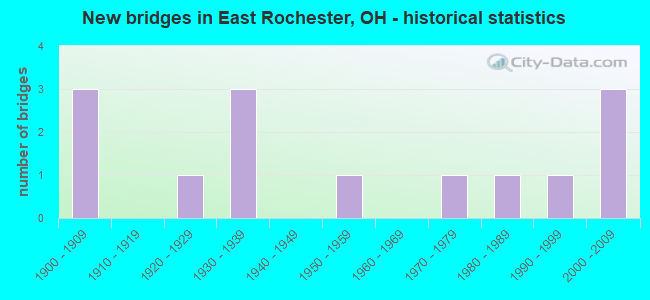
- New bridges - historical statistics
- 31900-1909
- 11920-1929
- 31930-1939
- 11950-1959
- 11970-1979
- 11980-1989
- 11990-1999
- 32000-2009

- Reconstructed bridges - Historical Statistics
- 31980-1989
- 01990-1999
- 32000-2009
- 12010-2019


- Bridge Condition - Deck
- 7.1%Excellent
- 42.9%Very good
- 42.9%Good
- 7.1%Satisfactory

- Bridge Condition - Superstructure
- 7.1%Excellent
- 57.1%Very good
- 21.4%Good
- 14.3%Satisfactory

- Bridge Condition - Substructure
- 7.1%Excellent
- 57.1%Very good
- 21.4%Good
- 7.1%Satisfactory
- 7.1%Fair

- Bridge Condition - Channel
- 50.0%Very good
- 28.6%Good
- 7.1%Satisfactory
- 7.1%Fair
- 7.1%Poor
Find on map >> Show street view
Structure Number: 1000195, Location: 3.0 MI.S.OF COLUMBIANA CO (Lat: 40.701450, Lng: -81.009969), Route carried "on" structure: State highway 9, Year Built: 2003, Status: Open, Structure Length: 0.80m (2.62ft), Average Daily Traffic: 1,697 (year 2015), Truck Traffic: 19%, Average Future Daily Traffic: 2,355 (year 2035), Design Load: HS 25 or greater, Features Intersected: MUDDY FORK CREEK
Minimum Vertical Clearance: 30+ m (98+ ft), Kilometerpoint: 40.314, Lanes on structure: 2, Base Highway Network: Yes, Owner: State Highway Agency, Approaching Roadway Width: 9.8m (32.2ft), Material/Design: Concrete, Design/Construction: Slab, Number Of Spans In Main Unit: 1, Length of Maximum Span: 7.6m (24.9ft), Curb-To-Curb Width: 9.8m (32.2ft), Out-to-Out Width: 9.8m (32.2ft)
Condition: Deck: Very good, Superstructure: Very good, Substructure: Excellent, Channel: Good, Operating Rating: 42.1 metric tons, Method Used To Determine Operating Rating: Load Factor (LF) rating reported by rating factor (RF) method using MS18 loading, Inventory Rating: 32.4 metric tons, Method Used To Determine Inventory Rating: Load Factor (LF) rating reported by rating factor (RF) method using MS18 loading, Structural Evaluation: Equal to present desirable criteria, Deck Geometry: Somewhat better than minimum adequacy, Waterway Adequacy: Equal to present minimum criteria, Approach Roadway Alignment: Equal to present desirable criteria, Designated Inspection Frequency: Every 24 months, Inspection Date: June 2021, Deck Structure Type: Concrete Cast-file-Place, Wearing Surface/Protective System: Wearing Surface: Monolithic Concrete, Deck Protection: Epoxy Coated Reinforcing
Find on map >> Show street view
Structure Number: 103224, Location: 700 FT SOUTH OF STRT 9 (Lat: 40.705731, Lng: -81.003189), Route carried "on" structure: County highway T0411, Year Built: 1976, Status: Open, Structure Length: 0.91m (2.99ft), Average Daily Traffic: 209 (year 2015), Truck Traffic: 7%, Average Future Daily Traffic: 290 (year 2035), Design Load: H 15, Features Intersected: MUDDY FR COXMANSION BN11, Facility Carried by Structure: AGUSTA TWP 411
Minimum Vertical Clearance: 30+ m (98+ ft), Kilometerpoint: 0.000, Lanes on structure: 2, Owner: County Highway Agency, Approaching Roadway Width: 6.1m (20.0ft), Material/Design: Steel, Design/Construction: Stringer/Multi-beam, Number Of Spans In Main Unit: 1, Length of Maximum Span: 8.5m (27.9ft), Curb-To-Curb Width: 7.3m (24.0ft), Out-to-Out Width: 7.3m (24.0ft)
Condition: Deck: Good, Superstructure: Good, Substructure: Fair, Channel: Good, Operating Rating: 45.4 metric tons, Method Used To Determine Operating Rating: Allowable Stress (AS) rating reported by rating factor (RF) method using MS18 loading, Inventory Rating: 42.1 metric tons, Method Used To Determine Inventory Rating: Allowable Stress (AS) rating reported by rating factor (RF) method using MS18 loading, Structural Evaluation: Somewhat better than minimum adequacy, Deck Geometry: Somewhat better than minimum adequacy, Waterway Adequacy: Equal to present desirable criteria, Approach Roadway Alignment: Equal to present desirable criteria, Designated Inspection Frequency: Every 12 months, Inspection Date: April 2021, Deck Structure Type: Corrugated Steel, Wearing Surface/Protective System: Wearing Surface: Bituminous
Find on map >> Show street view
Structure Number: 1033174, Location: 1000 FT SOUTH OF CR 43 (Lat: 40.702850, Lng: -81.043319), Route carried "on" structure: County highway C0030, Year Built: 2004, Status: Open, Structure Length: 1.22m (4.00ft), Average Daily Traffic: 122 (year 2015), Truck Traffic: 7%, Average Future Daily Traffic: 169 (year 2035), Design Load: HS 20+Mod, Features Intersected: MUDDY FORK LUCAS, Facility Carried by Structure: COUNTY ROAD 30
Minimum Vertical Clearance: 30+ m (98+ ft), Kilometerpoint: 15.562, Lanes on structure: 2, Owner: County Highway Agency, Approaching Roadway Width: 6.1m (20.0ft), Material/Design: Steel, Design/Construction: Stringer/Multi-beam, Number Of Spans In Main Unit: 1, Length of Maximum Span: 11.9m (39.0ft), Curb-To-Curb Width: 7.3m (24.0ft), Out-to-Out Width: 7.9m (25.9ft)
Condition: Deck: Good, Superstructure: Good, Substructure: Good, Channel: Good, Operating Rating: 64.8 metric tons, Method Used To Determine Operating Rating: Load Factor (LF) rating reported by rating factor (RF) method using MS18 loading, Inventory Rating: 38.9 metric tons, Method Used To Determine Inventory Rating: Load Factor (LF) rating reported by rating factor (RF) method using MS18 loading, Structural Evaluation: Better than present minimum criteria, Deck Geometry: Somewhat better than minimum adequacy, Waterway Adequacy: Equal to present desirable criteria, Approach Roadway Alignment: Equal to present desirable criteria, Designated Inspection Frequency: Every 24 months, Inspection Date: April 2021, Deck Structure Type: Corrugated Steel, Wearing Surface/Protective System: Wearing Surface: Bituminous
Find on map >> Show street view
Structure Number: 103319, Location: 0.1 MI S OF JCT CR 43 (Lat: 40.699739, Lng: -81.021961), Route carried "on" structure: County highway C0010, Year Built: 2005, Status: Open, Structure Length: 1.01m (3.31ft), Average Daily Traffic: 405 (year 2015), Truck Traffic: 8%, Average Future Daily Traffic: 562 (year 2035), Design Load: HS 20+Mod, Features Intersected: MUDDY FORK - HAWK BN101, Facility Carried by Structure: COUNTY ROAD 10
Minimum Vertical Clearance: 30+ m (98+ ft), Kilometerpoint: 16.818, Lanes on structure: 2, Owner: County Highway Agency, Approaching Roadway Width: 5.5m (18.0ft), Material/Design: Steel, Design/Construction: Stringer/Multi-beam, Number Of Spans In Main Unit: 1, Length of Maximum Span: 9.8m (32.2ft), Curb-To-Curb Width: 7.3m (24.0ft), Out-to-Out Width: 7.9m (25.9ft)
Condition: Deck: Good, Superstructure: Very good, Substructure: Very good, Channel: Poor, Operating Rating: 58.3 metric tons, Method Used To Determine Operating Rating: Allowable Stress (AS) rating reported by rating factor (RF) method using MS18 loading, Inventory Rating: 38.9 metric tons, Method Used To Determine Inventory Rating: Allowable Stress (AS) rating reported by rating factor (RF) method using MS18 loading, Structural Evaluation: Equal to present desirable criteria, Deck Geometry: Meets minimum limits, Waterway Adequacy: Equal to present desirable criteria, Approach Roadway Alignment: Equal to present desirable criteria, Designated Inspection Frequency: Every 24 months, Inspection Date: April 2021, Deck Structure Type: Corrugated Steel, Wearing Surface/Protective System: Wearing Surface: Bituminous
Find on map >> Show street view
Structure Number: 1501542, Location: .12 MI E OF CONRAIL RR (Lat: 40.748219, Lng: -81.043669), Route carried "on" structure: US 30, Year Built: 1983, Status: Open, Structure Length: 1.52m (4.99ft), Average Daily Traffic: 5,659 (year 2018), Truck Traffic: 12%, Average Future Daily Traffic: 7,855 (year 2038), Design Load: HS 20+Mod, Features Intersected: SANDY CREEK
Minimum Vertical Clearance: 30+ m (98+ ft), Kilometerpoint: 3.991, Lanes on structure: 2, Base Highway Network: Yes, Owner: State Highway Agency, Approaching Roadway Width: 12.2m (40.0ft), Skew: 1 degrees, Material/Design: Prestressed concrete, Design/Construction: Box Beam or Girders - Multiple, Number Of Spans In Main Unit: 1, Length of Maximum Span: 14.9m (48.9ft), Curb-To-Curb Width: 12.2m (40.0ft), Out-to-Out Width: 12.3m (40.4ft)
Condition: Deck: Satisfactory, Superstructure: Satisfactory, Substructure: Satisfactory, Channel: Fair, Operating Rating: 42.1 metric tons, Method Used To Determine Operating Rating: Load Factor (LF) rating reported by rating factor (RF) method using MS18 loading, Inventory Rating: 32.4 metric tons, Method Used To Determine Inventory Rating: Load Factor (LF) rating reported by rating factor (RF) method using MS18 loading, Structural Evaluation: Equal to present minimum criteria, Deck Geometry: Somewhat better than minimum adequacy, Waterway Adequacy: Better than present minimum criteria, Approach Roadway Alignment: Better than present minimum criteria, Designated Inspection Frequency: Every 12 months, Inspection Date: May 2021, Deck Structure Type: Concrete Cast-file-Place, Wearing Surface/Protective System: Wearing Surface: Bituminous, Membrane: Built-up
Find on map >> Show street view
Structure Number: 1531417, Location: 0.0 MI N T816 (Lat: 40.757489, Lng: -81.030481), Route carried "on" structure: County highway C0402, Year Built: 1921, Status: Open, Structure Length: 1.22m (4.00ft), Average Daily Traffic: 495 (year 2015), Truck Traffic: 7%, Average Future Daily Traffic: 687 (year 2035), Design Load: HS 20, Features Intersected: NO NAME STREAM, Facility Carried by Structure: ROCHESTER RD 402
Minimum Vertical Clearance: 30+ m (98+ ft), Kilometerpoint: 0.917, Lanes on structure: 2, Owner: County Highway Agency, Approaching Roadway Width: 7.3m (24.0ft), Skew: 3 degrees, Material/Design: Concrete, Design/Construction: Tee Beam, Number Of Spans In Main Unit: 1, Length of Maximum Span: 11.0m (36.1ft), Curb-To-Curb Width: 6.1m (20.0ft), Out-to-Out Width: 6.9m (22.6ft)
Condition: Deck: Good, Superstructure: Satisfactory, Substructure: Good, Channel: Satisfactory, Operating Rating: 38.9 metric tons, Method Used To Determine Operating Rating: Load Factor (LF) rating reported by rating factor (RF) method using MS18 loading, Inventory Rating: 22.7 metric tons, Method Used To Determine Inventory Rating: Load Factor (LF) rating reported by rating factor (RF) method using MS18 loading, Structural Evaluation: Equal to present minimum criteria, Deck Geometry: High priority of corrective action, Waterway Adequacy: Equal to present desirable criteria, Approach Roadway Alignment: Better than present minimum criteria, Designated Inspection Frequency: Every 12 months, Inspection Date: July 2021, Deck Structure Type: Concrete Cast-file-Place, Wearing Surface/Protective System: Wearing Surface: Bituminous
Find on map >> Show street view
Structure Number: 1535595, Location: 0.0 MI E T810 (Lat: 40.780650, Lng: -81.070561), Route carried "on" structure: County highway T0703, Year Built: 1900, Year Reconstructed: 1987, Status: Open, Structure Length: 1.16m (3.81ft), Average Daily Traffic: 221 (year 2015), Truck Traffic: 8%, Average Future Daily Traffic: 307 (year 2035), Design Load: HS 20, Features Intersected: NO NAME, Facility Carried by Structure: BAYARD RD 703
Minimum Vertical Clearance: 30+ m (98+ ft), Kilometerpoint: 2.945, Lanes on structure: 2, Owner: County Highway Agency, Approaching Roadway Width: 5.5m (18.0ft), Material/Design: Steel, Design/Construction: Stringer/Multi-beam, Number Of Spans In Main Unit: 1, Length of Maximum Span: 11.3m (37.1ft), Curb-To-Curb Width: 7.3m (24.0ft), Out-to-Out Width: 7.5m (24.6ft)
Condition: Deck: Very good, Superstructure: Very good, Substructure: Very good, Channel: Very good, Operating Rating: 61.6 metric tons, Method Used To Determine Operating Rating: Load Factor (LF) rating reported by rating factor (RF) method using MS18 loading, Inventory Rating: 38.9 metric tons, Method Used To Determine Inventory Rating: Load Factor (LF) rating reported by rating factor (RF) method using MS18 loading, Structural Evaluation: Equal to present desirable criteria, Deck Geometry: Somewhat better than minimum adequacy, Waterway Adequacy: Equal to present desirable criteria, Approach Roadway Alignment: Equal to present desirable criteria, Designated Inspection Frequency: Every 24 months, Inspection Date: July 2021, Deck Structure Type: Open Grating
Find on map >> Show street view
Structure Number: 1535706, Location: 0.0 MI S SR30 (Lat: 40.741381, Lng: -81.006650), Route carried "on" structure: County highway T0709, Year Built: 1900, Year Reconstructed: 2000, Status: Open, Structure Length: 0.98m (3.22ft), Average Daily Traffic: 324 (year 2015), Truck Traffic: 7%, Average Future Daily Traffic: 450 (year 2035), Design Load: HS 20, Features Intersected: SANDY CREEK, Facility Carried by Structure: LIPPINCOTT RD 709
Minimum Vertical Clearance: 30+ m (98+ ft), Kilometerpoint: 1.175, Lanes on structure: 2, Owner: County Highway Agency, Approaching Roadway Width: 6.7m (22.0ft), Material/Design: Steel, Design/Construction: Stringer/Multi-beam, Number Of Spans In Main Unit: 1, Length of Maximum Span: 9.4m (30.8ft), Curb-To-Curb Width: 5.5m (18.0ft), Out-to-Out Width: 5.5m (18.0ft)
Condition: Deck: Very good, Superstructure: Very good, Substructure: Very good, Channel: Good, Operating Rating: 51.8 metric tons, Method Used To Determine Operating Rating: Allowable Stress (AS) rating reported by rating factor (RF) method using MS18 loading, Inventory Rating: 32.4 metric tons, Method Used To Determine Inventory Rating: Allowable Stress (AS) rating reported by rating factor (RF) method using MS18 loading, Structural Evaluation: Equal to present desirable criteria, Waterway Adequacy: Equal to present desirable criteria, Approach Roadway Alignment: Better than present minimum criteria, Designated Inspection Frequency: Every 24 months, Inspection Date: July 2021, Deck Structure Type: Open Grating, Wearing Surface/Protective System: Wearing Surface: Bituminous
Find on map >> Show street view
Structure Number: 1535803, Location: 0.0 MI S SR30 (Lat: 40.745169, Lng: -81.034611), Route carried "on" structure: County highway T0723, Year Built: 1933, Year Reconstructed: 2010, Status: Open, Structure Length: 1.31m (4.30ft), Average Daily Traffic: 324 (year 2015), Truck Traffic: 7%, Average Future Daily Traffic: 450 (year 2035), Design Load: HS 20, Features Intersected: SANDY CREEK, Facility Carried by Structure: AUGUSTA RD 723
Minimum Vertical Clearance: 30+ m (98+ ft), Kilometerpoint: 0.933, Lanes on structure: 2, Owner: County Highway Agency, Approaching Roadway Width: 8.2m (26.9ft), Material/Design: Steel, Design/Construction: Stringer/Multi-beam, Number Of Spans In Main Unit: 1, Length of Maximum Span: 12.5m (41.0ft), Curb-To-Curb Width: 7.3m (24.0ft), Out-to-Out Width: 7.3m (24.0ft)
Condition: Deck: Good, Superstructure: Very good, Substructure: Very good, Channel: Very good, Operating Rating: 64.8 metric tons, Method Used To Determine Operating Rating: Load Factor (LF) rating reported by rating factor (RF) method using MS18 loading, Inventory Rating: 38.9 metric tons, Method Used To Determine Inventory Rating: Load Factor (LF) rating reported by rating factor (RF) method using MS18 loading, Structural Evaluation: Equal to present desirable criteria, Deck Geometry: Somewhat better than minimum adequacy, Waterway Adequacy: Equal to present desirable criteria, Approach Roadway Alignment: Equal to present desirable criteria, Designated Inspection Frequency: Every 24 months, Inspection Date: July 2021, Deck Structure Type: Corrugated Steel, Wearing Surface/Protective System: Wearing Surface: Bituminous
Find on map >> Show street view
Structure Number: 1536745, Location: 0.2 MI W C402 (Lat: 40.752131, Lng: -81.038419), Route carried "on" structure: County highway T0817, Year Built: 1930, Year Reconstructed: 1991, Status: Open, Structure Length: 0.88m (2.89ft), Average Daily Traffic: 324 (year 2015), Truck Traffic: 7%, Average Future Daily Traffic: 450 (year 2035), Design Load: HS 20, Features Intersected: NO NAME, Facility Carried by Structure: SANDY CREEK 817
Minimum Vertical Clearance: 30+ m (98+ ft), Kilometerpoint: 4.748, Lanes on structure: 2, Owner: County Highway Agency, Approaching Roadway Width: 6.7m (22.0ft), Material/Design: Prestressed concrete, Design/Construction: Box Beam or Girders - Multiple, Number Of Spans In Main Unit: 1, Length of Maximum Span: 8.2m (26.9ft), Curb-To-Curb Width: 6.1m (20.0ft), Out-to-Out Width: 6.1m (20.0ft)
Condition: Deck: Very good, Superstructure: Very good, Substructure: Good, Channel: Very good, Operating Rating: 48.6 metric tons, Method Used To Determine Operating Rating: Load and Resistance Factor Rating (LRFR) rating reported by rating factor(RF) method using HL-93 loadings, Inventory Rating: 38.9 metric tons, Method Used To Determine Inventory Rating: Load and Resistance Factor Rating (LRFR) rating reported by rating factor(RF) method using HL-93 loadings, Structural Evaluation: Better than present minimum criteria, Deck Geometry: Meets minimum limits, Waterway Adequacy: Equal to present desirable criteria, Approach Roadway Alignment: Equal to present desirable criteria, Designated Inspection Frequency: Every 24 months, Inspection Date: July 2021, Deck Structure Type: Other, Wearing Surface/Protective System: Wearing Surface: Bituminous
Find on map >> Show street view
Structure Number: 1536753, Location: 0.2 MI E T703 (Lat: 40.776450, Lng: -81.067331), Route carried "on" structure: County highway T0820, Year Built: 1930, Year Reconstructed: 1989, Status: Open, Structure Length: 1.22m (4.00ft), Average Daily Traffic: 209 (year 2015), Truck Traffic: 7%, Average Future Daily Traffic: 290 (year 2035), Design Load: HS 20, Features Intersected: SANDY CREEK, Facility Carried by Structure: SANDY SPRING 820
Minimum Vertical Clearance: 30+ m (98+ ft), Kilometerpoint: 4.522, Lanes on structure: 2, Owner: County Highway Agency, Approaching Roadway Width: 5.5m (18.0ft), Material/Design: Prestressed concrete, Design/Construction: Box Beam or Girders - Multiple, Number Of Spans In Main Unit: 1, Length of Maximum Span: 11.3m (37.1ft), Curb-To-Curb Width: 6.1m (20.0ft), Out-to-Out Width: 6.1m (20.0ft)
Condition: Deck: Very good, Superstructure: Very good, Substructure: Very good, Channel: Very good, Operating Rating: 68.0 metric tons, Method Used To Determine Operating Rating: Load Factor (LF) rating reported by rating factor (RF) method using MS18 loading, Inventory Rating: 38.9 metric tons, Method Used To Determine Inventory Rating: Load Factor (LF) rating reported by rating factor (RF) method using MS18 loading, Structural Evaluation: Equal to present desirable criteria, Deck Geometry: Meets minimum limits, Waterway Adequacy: Equal to present desirable criteria, Approach Roadway Alignment: Equal to present desirable criteria, Length Of Structure Improvement: 1.10m (3.61ft), Designated Inspection Frequency: Every 24 months, Inspection Date: July 2021, Roadway Improvement Cost: $3,000, Total Project Cost: $30,000, Deck Structure Type: Other, Wearing Surface/Protective System: Wearing Surface: Bituminous
Find on map >> Show street view
Structure Number: 1536796, Location: 0.2 MI E T703 (Lat: 40.767689, Lng: -81.068019), Route carried "on" structure: County highway T0825, Year Built: 1900, Year Reconstructed: 2008, Status: Open, Structure Length: 0.94m (3.08ft), Average Daily Traffic: 209 (year 2015), Truck Traffic: 7%, Average Future Daily Traffic: 290 (year 2035), Design Load: HS 20, Features Intersected: SANDY CREEK, Facility Carried by Structure: RINKER RD 825
Minimum Vertical Clearance: 30+ m (98+ ft), Kilometerpoint: 3.557, Lanes on structure: 2, Owner: County Highway Agency, Approaching Roadway Width: 6.1m (20.0ft), Material/Design: Steel, Design/Construction: Stringer/Multi-beam, Number Of Spans In Main Unit: 1, Length of Maximum Span: 8.8m (28.9ft), Curb-To-Curb Width: 5.5m (18.0ft), Out-to-Out Width: 5.5m (18.0ft)
Condition: Deck: Excellent, Superstructure: Excellent, Substructure: Very good, Channel: Very good, Operating Rating: 81.0 metric tons, Method Used To Determine Operating Rating: Load Factor (LF) rating reported by rating factor (RF) method using MS18 loading, Inventory Rating: 48.6 metric tons, Method Used To Determine Inventory Rating: Load Factor (LF) rating reported by rating factor (RF) method using MS18 loading, Structural Evaluation: Equal to present desirable criteria, Deck Geometry: High priority of corrective action, Waterway Adequacy: Equal to present desirable criteria, Approach Roadway Alignment: Equal to present desirable criteria, Designated Inspection Frequency: Every 24 months, Inspection Date: July 2021, Deck Structure Type: Open Grating
Find on map >> Show street view
Structure Number: 1537989, Location: 0.1 MI S C402 (Lat: 40.764661, Lng: -81.020931), Route carried "on" structure: County highway T0981, Year Built: 1950, Year Reconstructed: 2013, Status: Open, Structure Length: 0.82m (2.69ft), Average Daily Traffic: 895 (year 2015), Truck Traffic: 7%, Average Future Daily Traffic: 1,242 (year 2035), Design Load: HS 20, Features Intersected: CONSER RUN, Facility Carried by Structure: WALTERS RD 981
Minimum Vertical Clearance: 30+ m (98+ ft), Kilometerpoint: 4.957, Lanes on structure: 2, Owner: County Highway Agency, Approaching Roadway Width: 6.4m (21.0ft), Material/Design: Steel, Design/Construction: Stringer/Multi-beam, Number Of Spans In Main Unit: 1, Length of Maximum Span: 7.6m (24.9ft), Curb-To-Curb Width: 5.5m (18.0ft), Out-to-Out Width: 5.5m (18.0ft)
Condition: Deck: Very good, Superstructure: Very good, Substructure: Very good, Channel: Very good, Operating Rating: 64.8 metric tons, Method Used To Determine Operating Rating: Load Factor (LF) rating reported by rating factor (RF) method using MS18 loading, Inventory Rating: 38.9 metric tons, Method Used To Determine Inventory Rating: Load Factor (LF) rating reported by rating factor (RF) method using MS18 loading, Structural Evaluation: Equal to present desirable criteria, Waterway Adequacy: Better than present minimum criteria, Approach Roadway Alignment: Equal to present desirable criteria, Designated Inspection Frequency: Every 24 months, Inspection Date: July 2021, Deck Structure Type: Open Grating
Find on map >> Show street view
Structure Number: 1538551, Location: 0.0 MI S SR 30 (Lat: 40.741181, Lng: -80.999981), Route carried "on" structure: County highway T0713, Year Built: 1993, Status: Open, Structure Length: 0.70m (2.30ft), Average Daily Traffic: 324 (year 2015), Truck Traffic: 7%, Average Future Daily Traffic: 450 (year 2035), Design Load: HS 20, Features Intersected: SANDY CREEK, Facility Carried by Structure: LYNCHBURG RD 713
Minimum Vertical Clearance: 30+ m (98+ ft), Kilometerpoint: 1.465, Lanes on structure: 2, Owner: County Highway Agency, Approaching Roadway Width: 9.8m (32.2ft), Material/Design: Concrete, Design/Construction: Frame, Number Of Spans In Main Unit: 1, Length of Maximum Span: 6.7m (22.0ft), Curb-To-Curb Width: 9.8m (32.2ft), Out-to-Out Width: 9.8m (32.2ft)
Condition: Deck: Good, Superstructure: Good, Substructure: Very good, Channel: Very good, Operating Rating: 48.6 metric tons, Method Used To Determine Operating Rating: Load Factor (LF) rating reported by rating factor (RF) method using MS18 loading, Inventory Rating: 29.2 metric tons, Method Used To Determine Inventory Rating: Load Factor (LF) rating reported by rating factor (RF) method using MS18 loading, Structural Evaluation: Better than present minimum criteria, Deck Geometry: Better than present minimum criteria, Waterway Adequacy: Equal to present desirable criteria, Approach Roadway Alignment: Equal to present desirable criteria, Designated Inspection Frequency: Every 24 months, Inspection Date: July 2021, Deck Structure Type: Concrete Cast-file-Place, Wearing Surface/Protective System: Wearing Surface: Bituminous, Membrane: Preformed Fabric