Bridge Statistics for Eden, New York (NY)
Condition, Traffic, Stress, Structural Evaluation, Project Costs
- National Bridge Inventory (NBI) Statistics
- 13Number of bridges
- 318ft / 96.7mTotal length
- $77,356,000Total costs
- 45,067Total average daily traffic
- 6,927Total average daily truck traffic
- National Bridge Inventory (NBI) Registered Bridges for Eden
- No street view available for this location
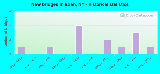
- New bridges - historical statistics
- 11910-1919
- 11930-1939
- 41950-1959
- 21970-1979
- 11980-1989
- 31990-1999
- 12000-2009

- Reconstructed bridges - Historical Statistics
- 11980-1989
- 01990-1999
- 22000-2009


- Bridge Condition - Deck
- 25.0%Very good
- 37.5%Good
- 37.5%Fair

- Bridge Condition - Superstructure
- 50.0%Very good
- 12.5%Good
- 25.0%Satisfactory
- 12.5%Critical

- Bridge Condition - Substructure
- 25.0%Very good
- 62.5%Good
- 12.5%Fair

- Bridge Condition - Channel
- 33.3%Very good
- 44.4%Good
- 22.2%Satisfactory
Find on map >> Show street view
Structure Number: 10282, Location: 1.3 MI SW INT RTS 62 + 75 (Lat: 42.678289, Lng: -78.873553), Route carried "on" structure: US 62, Year Built: 1991, Status: Open, Structure Length: 33.99m (111.52ft), Average Daily Traffic: 7,542 (year 2019), Truck Traffic: 6%, Average Future Daily Traffic: 7,577 (year 2040), Design Load: HS 20, Features Intersected: MILL ROAD, EIGHTEEN MILE
Minimum Vertical Clearance: 30+ m (98+ ft), Kilometerpoint: 26.259, Lanes on structure: 2, Lanes under structure: 2, Base Highway Network: Yes, Owner: State Highway Agency, Approaching Roadway Width: 12.2m (40.0ft), Material/Design: Steel continuous, Design/Construction: Stringer/Multi-beam, Number Of Spans In Main Unit: 7, Length of Maximum Span: 57.9m (190.0ft), Curb-To-Curb Width: 12.2m (40.0ft), Out-to-Out Width: 13.0m (42.7ft)
Condition: Deck: Very good, Superstructure: Very good, Substructure: Very good, Channel: Very good, Operating Rating: 67.1 metric tons, Method Used To Determine Operating Rating: Load Factor (LF), Inventory Rating: 36.3 metric tons, Method Used To Determine Inventory Rating: Load Factor (LF), Structural Evaluation: Equal to present desirable criteria, Deck Geometry: Somewhat better than minimum adequacy, Underclear: Superior to present desirable criteria, Waterway Adequacy: Somewhat better than minimum adequacy, Approach Roadway Alignment: Equal to present desirable criteria, Length Of Structure Improvement: 33.98m (111.48ft), Designated Inspection Frequency: Every 24 months, Inspection Date: April 2021, Bridge Improvement Cost: $14,883,000, Roadway Improvement Cost: $8,716,000, Total Project Cost: $23,599,000 ( Estimate for 2021), Deck Structure Type: Concrete Cast-file-Place, Wearing Surface/Protective System: Wearing Surface: Integral Concrete, Deck Protection: Epoxy Coated Reinforcing
Find on map >> Show street view
Structure Number: 102989, Location: 3 MI N JCT SH 75 & SH 249 (Lat: 42.630375, Lng: -78.844267), Route carried "on" structure: State highway 75, Year Built: 1979, Status: Open, Structure Length: 3.26m (10.70ft), Average Daily Traffic: 1,528 (year 2020), Truck Traffic: 7%, Average Future Daily Traffic: 1,543 (year 2040), Design Load: HS 20, Features Intersected: S B 18 MILE CREEK
Minimum Vertical Clearance: 30+ m (98+ ft), Kilometerpoint: 15.720, Lanes on structure: 2, Base Highway Network: Yes, Owner: State Highway Agency, Approaching Roadway Width: 12.8m (42.0ft), Skew: 1 degrees, Material/Design: Prestressed concrete, Design/Construction: Box Beam or Girders - Multiple, Number Of Spans In Main Unit: 1, Length of Maximum Span: 32.0m (105.0ft), Curb-To-Curb Width: 13.5m (44.3ft), Out-to-Out Width: 14.4m (47.2ft)
Condition: Deck: Good, Superstructure: Good, Substructure: Good, Channel: Good, Operating Rating: 71.6 metric tons, Method Used To Determine Operating Rating: Load and Resistance Factor Rating (LRFR) rating reported by rating factor(RF) method using HL-93 loadings, Inventory Rating: 22.0 metric tons, Method Used To Determine Inventory Rating: Load and Resistance Factor Rating (LRFR) rating reported by rating factor(RF) method using HL-93 loadings, Structural Evaluation: Somewhat better than minimum adequacy, Deck Geometry: Superior to present desirable criteria, Waterway Adequacy: Equal to present minimum criteria, Approach Roadway Alignment: Equal to present desirable criteria, Length Of Structure Improvement: 3.26m (10.70ft), Designated Inspection Frequency: Every 24 months, Inspection Date: September 2021, Bridge Improvement Cost: $1,493,000, Roadway Improvement Cost: $874,000, Total Project Cost: $2,368,000 ( Estimate for 2021), Wearing Surface/Protective System: Wearing Surface: Bituminous, Membrane: Other
Find on map >> Show street view
Structure Number: 226081, Location: 1.8 MI. SW OF EDEN (Lat: 42.639644, Lng: -78.926733), Route carried "on" structure: Other road , Year Built: 1972, Status: Open, Structure Length: 0.64m (2.10ft), Average Daily Traffic: 371 (year 2017), Truck Traffic: 7%, Average Future Daily Traffic: 519 (year 2037), Features Intersected: RYTHUS CREEK, Facility Carried by Structure: NEW JERUSALEM RD.
Minimum Vertical Clearance: 30+ m (98+ ft), Kilometerpoint: 1.223, Lanes on structure: 2, Owner: Town or Township Highway Agency, Approaching Roadway Width: 6.1m (20.0ft), Skew: 5 degrees, Material/Design: Steel, Design/Construction: Culvert, Number Of Spans In Main Unit: 2, Length of Maximum Span: 3.0m (9.8ft)
Condition: Channel: Satisfactory, Culverts: Fair, Operating Rating: 73.8 metric tons, Method Used To Determine Operating Rating: Field evaluation and documented engineering judgment, Inventory Rating: 19.6 metric tons, Method Used To Determine Inventory Rating: Field evaluation and documented engineering judgment, Structural Evaluation: Somewhat better than minimum adequacy, Waterway Adequacy: Better than present minimum criteria, Approach Roadway Alignment: Equal to present desirable criteria, Length Of Structure Improvement: 0.64m (2.10ft), Designated Inspection Frequency: Every 24 months, Inspection Date: April 2020, Bridge Improvement Cost: $108,000, Roadway Improvement Cost: $63,000, Total Project Cost: $171,000 ( Estimate for 2021), Wearing Surface/Protective System: Wearing Surface: Bituminous
Find on map >> Show street view
Structure Number: 332762, Location: 3.4 MI NW OF NEW OREGON (Lat: 42.624906, Lng: -78.838042), Route carried "on" structure: County highway , Year Built: 1994, Status: Open, Structure Length: 2.56m (8.40ft), Average Daily Traffic: 338 (year 2017), Truck Traffic: 5%, Average Future Daily Traffic: 473 (year 2037), Design Load: HS 25 or greater, Features Intersected: S BR 18 MILE CRK, Facility Carried by Structure: NEW OREGON ROAD
Minimum Vertical Clearance: 30+ m (98+ ft), Kilometerpoint: 13.773, Lanes on structure: 2, Owner: County Highway Agency, Approaching Roadway Width: 6.1m (20.0ft), Material/Design: Steel, Design/Construction: Stringer/Multi-beam, Number Of Spans In Main Unit: 1, Length of Maximum Span: 24.3m (79.7ft), Curb-To-Curb Width: 8.5m (27.9ft), Out-to-Out Width: 9.1m (29.9ft)
Condition: Deck: Good, Superstructure: Very good, Substructure: Very good, Channel: Satisfactory, Operating Rating: 59.3 metric tons, Method Used To Determine Operating Rating: Load and Resistance Factor Rating (LRFR) rating reported by rating factor(RF) method using HL-93 loadings, Inventory Rating: 46.0 metric tons, Method Used To Determine Inventory Rating: Load and Resistance Factor Rating (LRFR) rating reported by rating factor(RF) method using HL-93 loadings, Structural Evaluation: Equal to present desirable criteria, Deck Geometry: Equal to present minimum criteria, Waterway Adequacy: Equal to present desirable criteria, Approach Roadway Alignment: Better than present minimum criteria, Length Of Structure Improvement: 2.56m (8.40ft), Designated Inspection Frequency: Every 24 months, Inspection Date: April 2020, Bridge Improvement Cost: $1,273,000, Roadway Improvement Cost: $746,000, Total Project Cost: $2,019,000 ( Estimate for 2021), Deck Structure Type: Concrete Cast-file-Place, Wearing Surface/Protective System: Wearing Surface: Integral Concrete
Find on map >> Show street view
Structure Number: 332776, Location: .4 MI NW OF EDEN VALLEY (Lat: 42.680392, Lng: -78.878675), Route carried "on" structure: County highway , Year Built: 1988, Status: Open, Structure Length: 4.21m (13.81ft), Average Daily Traffic: 554 (year 2020), Truck Traffic: 3%, Average Future Daily Traffic: 776 (year 2040), Design Load: HS 20, Features Intersected: S B 18 MILE CREEK, Facility Carried by Structure: BLEY ROAD
Minimum Vertical Clearance: 30+ m (98+ ft), Kilometerpoint: 0.805, Lanes on structure: 2, Owner: County Highway Agency, Approaching Roadway Width: 8.5m (27.9ft), Material/Design: Steel, Design/Construction: Stringer/Multi-beam, Number Of Spans In Main Unit: 1, Length of Maximum Span: 40.5m (132.9ft), Curb-To-Curb Width: 8.5m (27.9ft), Out-to-Out Width: 9.1m (29.9ft)
Condition: Deck: Good, Superstructure: Very good, Substructure: Good, Channel: Very good, Inventory Rating: 32.7 metric tons, Method Used To Determine Inventory Rating: Field evaluation and documented engineering judgment, Structural Evaluation: Better than present minimum criteria, Deck Geometry: Somewhat better than minimum adequacy, Waterway Adequacy: Superior to present desirable criteria, Approach Roadway Alignment: Equal to present desirable criteria, Length Of Structure Improvement: 4.20m (13.78ft), Designated Inspection Frequency: Every 24 months, Inspection Date: November 2020, Bridge Improvement Cost: $1,847,000, Roadway Improvement Cost: $1,082,000, Total Project Cost: $2,928,000 ( Estimate for 2021), Deck Structure Type: Concrete Cast-file-Place, Wearing Surface/Protective System: Wearing Surface: Integral Concrete, Deck Protection: Epoxy Coated Reinforcing
Find on map >> Show street view
Structure Number: 332781, Location: 2.5 MI SE OF EDEN VALLEY (Lat: 42.643711, Lng: -78.853994), Route carried "on" structure: County highway , Year Built: 2002, Status: Open, Structure Length: 9.39m (30.81ft), Average Daily Traffic: 1,216 (year 2020), Truck Traffic: 8%, Average Future Daily Traffic: 1,504 (year 2040), Design Load: HS 25 or greater, Features Intersected: EIGHTEEN MILE CRK, Facility Carried by Structure: E CHURCH STREET
Minimum Vertical Clearance: 30+ m (98+ ft), Kilometerpoint: 3.894, Lanes on structure: 2, Owner: County Highway Agency, Approaching Roadway Width: 10.1m (33.1ft), Material/Design: Steel continuous, Design/Construction: Stringer/Multi-beam, Number Of Spans In Main Unit: 3, Length of Maximum Span: 42.0m (137.8ft), Curb-To-Curb Width: 10.2m (33.5ft), Out-to-Out Width: 11.2m (36.7ft)
Condition: Deck: Very good, Superstructure: Very good, Substructure: Good, Channel: Very good, Operating Rating: 45.7 metric tons, Method Used To Determine Operating Rating: Load and Resistance Factor Rating (LRFR) rating reported by rating factor(RF) method using HL-93 loadings, Inventory Rating: 35.3 metric tons, Method Used To Determine Inventory Rating: Load and Resistance Factor Rating (LRFR) rating reported by rating factor(RF) method using HL-93 loadings, Structural Evaluation: Better than present minimum criteria, Deck Geometry: Somewhat better than minimum adequacy, Waterway Adequacy: Equal to present minimum criteria, Approach Roadway Alignment: Meets minimum limits, Length Of Structure Improvement: 9.38m (30.77ft), Designated Inspection Frequency: Every 24 months, Inspection Date: July 2020, Bridge Improvement Cost: $3,861,000, Roadway Improvement Cost: $2,261,000, Total Project Cost: $6,122,000 ( Estimate for 2021), Deck Structure Type: Concrete Cast-file-Place, Wearing Surface/Protective System: Wearing Surface: Integral Concrete, Deck Protection: Galvanized Reinforcing
Find on map >> Show street view
Structure Number: 332789, Location: 2.9 MI NW OF NEW OREGON (Lat: 42.619561, Lng: -78.831278), Route carried "on" structure: Other road , Year Built: 1911, Year Reconstructed: 1988, Status: Closed, Structure Length: 3.20m (10.50ft), Average Daily Traffic: 335 (year 2017), Truck Traffic: 4%, Average Future Daily Traffic: 469 (year 2037), Design Load: H 15, Features Intersected: S BR 18 MILE CRK, Facility Carried by Structure: CLARKSBURG ROAD
Minimum Vertical Clearance: 4.88m (16.01ft), Kilometerpoint: 1.287, Lanes on structure: 1, Owner: County Highway Agency, Approaching Roadway Width: 3.7m (12.1ft), Material/Design: Steel, Design/Construction: Truss - Thru, Number Of Spans In Main Unit: 1, Length of Maximum Span: 31.3m (102.7ft), Curb-To-Curb Width: 4.4m (14.4ft), Out-to-Out Width: 5.0m (16.4ft)
Condition: Deck: Fair, Superstructure: Critical, Substructure: Fair, Channel: Good, Waterway Adequacy: Somewhat better than minimum adequacy, Approach Roadway Alignment: Meets minimum limits, Bridge Posting: Required (Relationship of Operating Rating to Maximum Legal Load: > 39.9% below), Length Of Structure Improvement: 3.20m (10.50ft), Designated Inspection Frequency: Every 12 months, Critical Feature Inspection Frequency: Every 12 months, Inspection Date: November 2021, Critical Feature Inspection Date: November 2021, Bridge Improvement Cost: $1,346,000, Roadway Improvement Cost: $788,000, Total Project Cost: $2,133,000 ( Estimate for 2021), Deck Structure Type: Wood or Timber, Wearing Surface/Protective System: Wearing Surface: Bituminous, Membrane: Other
Find on map >> Show street view
Structure Number: 5512411, Location: 2.7 MI. NE OF INT.57A (Lat: 42.692431, Lng: -78.932214), Route carried "on" structure: Interstate 90, Year Built: 1957, Year Reconstructed: 2012, Status: Open, Structure Length: 19.39m (63.62ft), Average Daily Traffic: 14,697 (year 2014), Truck Traffic: 22%, Design Load: HS 20+Mod, Features Intersected: EIGHTEEN MILE CREEK, SHA
Minimum Vertical Clearance: 30+ m (98+ ft), Kilometerpoint: 711.387, Lanes on structure: 2, Lanes under structure: 2, Base Highway Network: Yes, Toll: On Interstate toll segment, Owner: State Toll Authority, Approaching Roadway Width: 11.6m (38.1ft), Material/Design: Steel, Design/Construction: Girder and Floorbeam System, Number Of Spans In Main Unit: 5, Length of Maximum Span: 45.7m (149.9ft), Curb-To-Curb Width: 15.0m (49.2ft), Out-to-Out Width: 17.1m (56.1ft)
Condition: Deck: Fair, Superstructure: Satisfactory, Substructure: Good, Channel: Good, Operating Rating: 59.9 metric tons, Method Used To Determine Operating Rating: Load Factor (LF), Inventory Rating: 32.7 metric tons, Method Used To Determine Inventory Rating: Load Factor (LF), Structural Evaluation: Equal to present minimum criteria, Deck Geometry: Superior to present desirable criteria, Underclear: Meets minimum limits, Waterway Adequacy: Superior to present desirable criteria, Approach Roadway Alignment: Equal to present desirable criteria, Length Of Structure Improvement: 19.38m (63.58ft), Designated Inspection Frequency: Every 24 months, Critical Feature Inspection Frequency: Every 24 months, Inspection Date: September 2020, Critical Feature Inspection Date: September 2020, Bridge Improvement Cost: $11,825,000, Roadway Improvement Cost: $6,925,000, Total Project Cost: $18,749,000 ( Estimate for 2021), Deck Structure Type: Concrete Cast-file-Place, Wearing Surface/Protective System: Wearing Surface: Monolithic Concrete
Find on map >> Show street view
Structure Number: 5512412, Location: 2.7 MI. NE OF INT.57A (Lat: 42.692200, Lng: -78.931856), Route carried "on" structure: Interstate 90, Year Built: 1957, Year Reconstructed: 2012, Status: Open, Structure Length: 20.06m (65.81ft), Average Daily Traffic: 8,734 (year 2017), Truck Traffic: 34%, Average Future Daily Traffic: 9,788 (year 2040), Design Load: HS 20+Mod, Features Intersected: EIGHTEEN MILE CREEK, SHA
Minimum Vertical Clearance: 30+ m (98+ ft), Kilometerpoint: 19.759, Lanes on structure: 2, Lanes under structure: 2, Base Highway Network: Yes, Toll: On Interstate toll segment, Owner: State Toll Authority, Approaching Roadway Width: 11.6m (38.1ft), Material/Design: Steel, Design/Construction: Girder and Floorbeam System, Number Of Spans In Main Unit: 5, Length of Maximum Span: 45.7m (149.9ft), Curb-To-Curb Width: 14.9m (48.9ft), Out-to-Out Width: 17.1m (56.1ft)
Condition: Deck: Fair, Superstructure: Satisfactory, Substructure: Good, Channel: Good, Operating Rating: 59.9 metric tons, Method Used To Determine Operating Rating: Load Factor (LF), Inventory Rating: 32.7 metric tons, Method Used To Determine Inventory Rating: Load Factor (LF), Structural Evaluation: Equal to present minimum criteria, Deck Geometry: Superior to present desirable criteria, Underclear: High priority of corrective action, Waterway Adequacy: Superior to present desirable criteria, Approach Roadway Alignment: Equal to present desirable criteria, Length Of Structure Improvement: 20.05m (65.78ft), Designated Inspection Frequency: Every 24 months, Critical Feature Inspection Frequency: Every 24 months, Inspection Date: September 2020, Critical Feature Inspection Date: September 2020, Bridge Improvement Cost: $12,151,000, Roadway Improvement Cost: $7,116,000, Total Project Cost: $19,267,000 ( Estimate for 2021), Deck Structure Type: Concrete Cast-file-Place, Wearing Surface/Protective System: Wearing Surface: Monolithic Concrete
Find on map >> Show street view
Structure Number: 10282, Location: 1.3 MI SW INT RTS 62 + 75 (Lat: 42.678289, Lng: -78.873553), Route carried "under" structure: Other road , Year Built: 1991, Structure Length: 0. m, Features Intersected: MILL ROAD, EIGHTEEN MILE, Facility Carried by Structure: RTE 62
Minimum Vertical Clearance: 17.78m (58.33ft), Kilometerpoint: 0.000, Lanes on structure: 2, Lanes under structure: 2, Material/Design: Steel continuous, Design/Construction: Stringer/Multi-beam, Length of Maximum Span: 57.9m (190.0ft)
Find on map >> Show street view
Structure Number: 5512411, Location: 2.7 MI. NE OF INT.57A (Lat: 42.692431, Lng: -78.932214), Route carried "under" structure: County highway , Year Built: 1957, Structure Length: 0. m, Average Daily Traffic: 1,745 (year 2014), Features Intersected: EIGHTEEN MILE CREEK, SHA, Facility Carried by Structure: RTE I90
Minimum Vertical Clearance: 6.20m (20.34ft), Kilometerpoint: 0.000, Lanes on structure: 2, Lanes under structure: 2, Material/Design: Steel, Design/Construction: Girder and Floorbeam System, Length of Maximum Span: 45.7m (149.9ft)
Find on map >> Show street view
Structure Number: 5512412, Location: 2.7 MI. NE OF INT.57A (Lat: 42.692200, Lng: -78.931856), Route carried "under" structure: County highway , Year Built: 1957, Structure Length: 0. m, Average Daily Traffic: 1,745 (year 2014), Features Intersected: EIGHTEEN MILE CREEK, SHA, Facility Carried by Structure: RTE I90
Minimum Vertical Clearance: 4.37m (14.34ft), Kilometerpoint: 0.000, Lanes on structure: 2, Lanes under structure: 2, Material/Design: Steel, Design/Construction: Girder and Floorbeam System, Length of Maximum Span: 45.7m (149.9ft)
Find on map >> Show street view
Structure Number: 702819, Location: 3 MI N JCT US 62 & SH 249 (Lat: 42.633814, Lng: -78.918081), Route carried "under" structure: US 62, Year Built: 1936, Structure Length: 0. m, Average Daily Traffic: 6,262 (year 1999), Features Intersected: RTE 62, Facility Carried by Structure: BUFFALO SOUTHERN
Minimum Vertical Clearance: 4.26m (13.98ft), Kilometerpoint: 20.289, Lanes under structure: 2, Material/Design: Steel, Design/Construction: Girder and Floorbeam System, Length of Maximum Span: 30.7m (100.7ft)