Bridge Statistics for Edgerton, Kansas (KS)
Condition, Traffic, Stress, Structural Evaluation, Project Costs
- National Bridge Inventory (NBI) Statistics
- 41Number of bridges
- 541ft / 165mTotal length
- $337,000Total costs
- 131,016Total average daily traffic
- 25,482Total average daily truck traffic
- National Bridge Inventory (NBI) Registered Bridges for Edgerton
- No street view available for this location
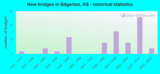
- New bridges - historical statistics
- 11910-1919
- 21930-1939
- 11940-1949
- 61950-1959
- 41980-1989
- 81990-1999
- 42000-2009
- 132010-2019
- 22020-2022

- Reconstructed bridges - Historical Statistics
- 11970-1979
- 31980-1989


- Bridge Condition - Deck
- 32.0%Very good
- 52.0%Good
- 16.0%Satisfactory

- Bridge Condition - Superstructure
- 44.0%Very good
- 32.0%Good
- 20.0%Satisfactory
- 4.0%Fair

- Bridge Condition - Substructure
- 36.0%Very good
- 56.0%Good
- 4.0%Satisfactory
- 4.0%Fair

- Bridge Condition - Channel
- 25.8%Very good
- 41.9%Good
- 29.0%Satisfactory
- 3.2%Fair

- Bridge Condition - Culverts
- 16.7%Very good
- 58.3%Good
- 25.0%Satisfactory
Find on map >> Show street view
Structure Number: 46008, Location: 1.0 E OF EDGERTON (Lat: 38.767658, Lng: -94.982719), Route carried "on" structure: County highway 347, Year Built: 2009, Status: Open, Structure Length: 4.95m (16.24ft), Average Daily Traffic: 1,959 (year 2016), Truck Traffic: 6%, Average Future Daily Traffic: 2,400 (year 2041), Design Load: HL 93, Features Intersected: BIG BULL CREEK, Facility Carried by Structure: 199TH ST. E.0-2.0
Minimum Vertical Clearance: 30.47m (99.97ft), Kilometerpoint: 0.000, Lanes on structure: 2, Owner: County Highway Agency, Approaching Roadway Width: 10.3m (33.8ft), Material/Design: Concrete continuous, Design/Construction: Slab, Number Of Spans In Main Unit: 3, Length of Maximum Span: 19.5m (64.0ft), Curb-To-Curb Width: 10.4m (34.1ft), Out-to-Out Width: 11.0m (36.1ft)
Condition: Deck: Very good, Superstructure: Very good, Substructure: Very good, Channel: Very good, Operating Rating: 44.5 metric tons, Method Used To Determine Operating Rating: Load and Resistance Factor (LRFR), Inventory Rating: 34.3 metric tons, Method Used To Determine Inventory Rating: Load and Resistance Factor (LRFR), Structural Evaluation: Equal to present desirable criteria, Deck Geometry: Equal to present minimum criteria, Waterway Adequacy: Equal to present desirable criteria, Approach Roadway Alignment: Equal to present desirable criteria, Designated Inspection Frequency: Every 24 months, Inspection Date: March 2021, Deck Structure Type: Concrete Cast-file-Place, Wearing Surface/Protective System: Deck Protection: Epoxy Coated Reinforcing
Find on map >> Show street view
Structure Number: 46019, Location: E. EDGERTON (Lat: 38.764858, Lng: -95.003614), Route carried "on" structure: City street 348, Year Built: 1986, Status: Open, Structure Length: 3.41m (11.19ft), Average Daily Traffic: 1,251 (year 2016), Truck Traffic: 6%, Average Future Daily Traffic: 1,500 (year 2041), Design Load: HS 20, Features Intersected: TRIB. TO BIG BULL CREEK, Facility Carried by Structure: NELSON RD C.9-1.8
Minimum Vertical Clearance: 30.47m (99.97ft), Kilometerpoint: 0.000, Lanes on structure: 2, Owner: City or Municipal Highway Agency, Approaching Roadway Width: 7.3m (24.0ft), Material/Design: Concrete continuous, Design/Construction: Slab, Number Of Spans In Main Unit: 3, Length of Maximum Span: 13.4m (44.0ft), Curb-To-Curb Width: 9.1m (29.9ft), Out-to-Out Width: 9.8m (32.2ft)
Condition: Deck: Good, Superstructure: Good, Substructure: Good, Channel: Good, Operating Rating: 62.3 metric tons, Method Used To Determine Operating Rating: Load Factor (LF), Inventory Rating: 37.3 metric tons, Method Used To Determine Inventory Rating: Load Factor (LF), Structural Evaluation: Better than present minimum criteria, Deck Geometry: Somewhat better than minimum adequacy, Waterway Adequacy: Equal to present desirable criteria, Approach Roadway Alignment: Better than present minimum criteria, Designated Inspection Frequency: Every 24 months, Inspection Date: March 2021, Deck Structure Type: Concrete Cast-file-Place, Wearing Surface/Protective System: Wearing Surface: Epoxy Overlay
Find on map >> Show street view
Structure Number: 46043, Location: 0.25N OF EDGERTON (Lat: 38.769672, Lng: -95.019231), Route carried "on" structure: County highway 348, Year Built: 1994, Status: Open, Structure Length: 1.31m (4.30ft), Average Daily Traffic: 869 (year 2016), Truck Traffic: 6%, Average Future Daily Traffic: 1,050 (year 2041), Design Load: HS 20, Features Intersected: MARTIN CREEK, Facility Carried by Structure: EDGERTON C.0-2.15
Minimum Vertical Clearance: 30.47m (99.97ft), Kilometerpoint: 0.000, Lanes on structure: 2, Owner: County Highway Agency, Approaching Roadway Width: 7.3m (24.0ft), Material/Design: Concrete, Design/Construction: Culvert, Number Of Spans In Main Unit: 3, Length of Maximum Span: 4.3m (14.1ft), Curb-To-Curb Width: 9.8m (32.2ft), Out-to-Out Width: 10.4m (34.1ft)
Condition: Channel: Satisfactory, Culverts: Satisfactory, Operating Rating: 91.4 metric tons, Method Used To Determine Operating Rating: Load Factor (LF), Inventory Rating: 54.7 metric tons, Method Used To Determine Inventory Rating: Load Factor (LF), Structural Evaluation: Equal to present minimum criteria, Deck Geometry: Equal to present minimum criteria, Waterway Adequacy: Better than present minimum criteria, Approach Roadway Alignment: Equal to present desirable criteria, Designated Inspection Frequency: Every 24 months, Inspection Date: March 2021
Find on map >> Show street view
Structure Number: 46044, Location: 0.3N OF EDGERTON (Lat: 38.771172, Lng: -95.019206), Route carried "on" structure: County highway 348, Year Built: 1994, Status: Open, Structure Length: 1.36m (4.46ft), Average Daily Traffic: 869 (year 2016), Truck Traffic: 6%, Average Future Daily Traffic: 1,050 (year 2041), Design Load: HS 20, Features Intersected: MARTIN CREEK TRIB., Facility Carried by Structure: EDGERTON C.0-2.30
Minimum Vertical Clearance: 30.47m (99.97ft), Kilometerpoint: 0.000, Lanes on structure: 2, Owner: County Highway Agency, Approaching Roadway Width: 7.3m (24.0ft), Skew: 3 degrees, Material/Design: Concrete, Design/Construction: Culvert, Number Of Spans In Main Unit: 3, Length of Maximum Span: 4.2m (13.8ft)
Condition: Channel: Satisfactory, Culverts: Satisfactory, Operating Rating: 91.5 metric tons, Method Used To Determine Operating Rating: Load Factor (LF), Inventory Rating: 54.8 metric tons, Method Used To Determine Inventory Rating: Load Factor (LF), Structural Evaluation: Equal to present minimum criteria, Waterway Adequacy: Better than present minimum criteria, Approach Roadway Alignment: Equal to present desirable criteria, Designated Inspection Frequency: Every 24 months, Inspection Date: March 2021
Find on map >> Show street view
Structure Number: 6102, Location: 2.0W 1.7S OF ANTIOCH (Lat: 38.700114, Lng: -94.982478), Route carried "on" structure: County highway 348, Year Built: 1980, Status: Open, Structure Length: 6.68m (21.92ft), Average Daily Traffic: 384 (year 2011), Truck Traffic: 10%, Average Future Daily Traffic: 1,571 (year 2041), Design Load: HS 20, Features Intersected: ROCK CREEK, Facility Carried by Structure: Spoon Creek Rd
Minimum Vertical Clearance: 30.47m (99.97ft), Kilometerpoint: 2.609, Lanes on structure: 2, Owner: County Highway Agency, Approaching Roadway Width: 10.9m (35.8ft), Material/Design: Concrete continuous, Design/Construction: Slab, Number Of Spans In Main Unit: 5, Length of Maximum Span: 14.6m (47.9ft), Curb-To-Curb Width: 10.9m (35.8ft), Out-to-Out Width: 11.6m (38.1ft)
Condition: Deck: Satisfactory, Superstructure: Satisfactory, Substructure: Good, Channel: Very good, Operating Rating: 66.2 metric tons, Method Used To Determine Operating Rating: Allowable Stress (AS), Inventory Rating: 39.9 metric tons, Method Used To Determine Inventory Rating: Allowable Stress (AS), Structural Evaluation: Equal to present minimum criteria, Deck Geometry: Better than present minimum criteria, Waterway Adequacy: Equal to present desirable criteria, Approach Roadway Alignment: Equal to present desirable criteria, Designated Inspection Frequency: Every 24 months, Underwater Inspection Frequency: Every 60 months, Inspection Date: June 2021, Underwater Inspection Date: September 2021, Deck Structure Type: Concrete Cast-file-Place
Find on map >> Show street view
Structure Number: 61021, Location: 11.2N 6.6W OF PAOLA (Lat: 38.734581, Lng: -95.000861), Route carried "on" structure: County highway 348, Year Built: 1997, Status: Open, Structure Length: 0.77m (2.53ft), Average Daily Traffic: 540 (year 2011), Truck Traffic: 10%, Average Future Daily Traffic: 2,700 (year 2041), Design Load: HS 20, Features Intersected: BIG BULL CREEK, Facility Carried by Structure: Sunflower Rd
Minimum Vertical Clearance: 30.47m (99.97ft), Kilometerpoint: 8.098, Lanes on structure: 2, Owner: County Highway Agency, Approaching Roadway Width: 7.5m (24.6ft), Material/Design: Concrete, Design/Construction: Culvert, Number Of Spans In Main Unit: 3, Length of Maximum Span: 2.4m (7.9ft)
Condition: Channel: Good, Culverts: Good, Operating Rating: 71.8 metric tons, Method Used To Determine Operating Rating: Load Factor (LF), Inventory Rating: 43.0 metric tons, Method Used To Determine Inventory Rating: Load Factor (LF), Structural Evaluation: Better than present minimum criteria, Waterway Adequacy: Equal to present minimum criteria, Approach Roadway Alignment: Equal to present desirable criteria, Designated Inspection Frequency: Every 24 months, Inspection Date: June 2021, Wearing Surface/Protective System: Wearing Surface: Bituminous
Find on map >> Show street view
Structure Number: 61052, Location: 1.0S 1.3W OF ANTIOCH (Lat: 38.711411, Lng: -94.968858), Route carried "on" structure: County highway 1030, Year Built: 1980, Status: Open, Structure Length: 7.59m (24.90ft), Average Daily Traffic: 220 (year 2011), Truck Traffic: 10%, Average Future Daily Traffic: 783 (year 2041), Design Load: HS 20, Features Intersected: BIG BULL CREEK, Facility Carried by Structure: 231st Street
Minimum Vertical Clearance: 30.47m (99.97ft), Kilometerpoint: 1.191, Lanes on structure: 2, Owner: County Highway Agency, Approaching Roadway Width: 11.0m (36.1ft), Material/Design: Concrete continuous, Design/Construction: Slab, Number Of Spans In Main Unit: 5, Length of Maximum Span: 15.8m (51.8ft), Curb-To-Curb Width: 10.9m (35.8ft), Out-to-Out Width: 11.6m (38.1ft)
Condition: Deck: Satisfactory, Superstructure: Satisfactory, Substructure: Good, Channel: Very good, Operating Rating: 56.5 metric tons, Method Used To Determine Operating Rating: Load Factor (LF), Inventory Rating: 33.6 metric tons, Method Used To Determine Inventory Rating: Load Factor (LF), Structural Evaluation: Equal to present minimum criteria, Deck Geometry: Better than present minimum criteria, Waterway Adequacy: Better than present minimum criteria, Approach Roadway Alignment: Equal to present desirable criteria, Designated Inspection Frequency: Every 24 months, Underwater Inspection Frequency: Every 60 months, Inspection Date: June 2021, Underwater Inspection Date: September 2021, Deck Structure Type: Concrete Cast-file-Place
Find on map >> Show street view
Structure Number: 610522, Location: 2.0S 6.5W OF SPRING HILL (Lat: 38.709356, Lng: -94.936583), Route carried "on" structure: County highway 1030, Year Built: 1980, Status: Open, Structure Length: 1.16m (3.81ft), Average Daily Traffic: 193 (year 2011), Truck Traffic: 10%, Average Future Daily Traffic: 713 (year 2041), Features Intersected: SMITH BR. OF BULL CREEK, Facility Carried by Structure: 231st Street
Minimum Vertical Clearance: 30.47m (99.97ft), Kilometerpoint: 4.041, Lanes on structure: 2, Owner: County Highway Agency, Approaching Roadway Width: 7.3m (24.0ft), Material/Design: Concrete, Design/Construction: Culvert, Number Of Spans In Main Unit: 3, Length of Maximum Span: 3.7m (12.1ft), Curb-To-Curb Width: 9.1m (29.9ft), Out-to-Out Width: 10.1m (33.1ft)
Condition: Channel: Satisfactory, Culverts: Good, Operating Rating: 45.4 metric tons, Method Used To Determine Operating Rating: Allowable Stress (AS), Inventory Rating: 28.1 metric tons, Method Used To Determine Inventory Rating: Allowable Stress (AS), Structural Evaluation: Better than present minimum criteria, Deck Geometry: Equal to present minimum criteria, Waterway Adequacy: Better than present minimum criteria, Approach Roadway Alignment: Equal to present desirable criteria, Designated Inspection Frequency: Every 24 months, Inspection Date: June 2021, Wearing Surface/Protective System: Wearing Surface: Bituminous
Find on map >> Show street view
Structure Number: 46106750468, Location: .48 mi. W of Edgerton Rd. (Lat: 38.782222, Lng: -95.028081), Route carried "on" structure: County highway , Year Built: 2009, Status: Open, Structure Length: 0.75m (2.46ft), Average Daily Traffic: 41 (year 2016), Truck Traffic: 5%, Average Future Daily Traffic: 50 (year 2041), Design Load: HS 20, Features Intersected: Martin Creek Trib, Facility Carried by Structure: 191st St. B.52-3.0
Minimum Vertical Clearance: 30.47m (99.97ft), Kilometerpoint: 0.000, Lanes on structure: 2, Owner: County Highway Agency, Approaching Roadway Width: 7.3m (24.0ft), Material/Design: Concrete, Design/Construction: Culvert, Number Of Spans In Main Unit: 2, Length of Maximum Span: 3.9m (12.8ft), Curb-To-Curb Width: 7.3m (24.0ft), Out-to-Out Width: 11.1m (36.4ft)
Condition: Channel: Satisfactory, Culverts: Good, Operating Rating: 84.3 metric tons, Method Used To Determine Operating Rating: Load Factor (LF), Inventory Rating: 50.4 metric tons, Method Used To Determine Inventory Rating: Load Factor (LF), Structural Evaluation: Better than present minimum criteria, Deck Geometry: Equal to present minimum criteria, Waterway Adequacy: Better than present minimum criteria, Approach Roadway Alignment: Equal to present desirable criteria, Designated Inspection Frequency: Every 24 months, Inspection Date: March 2021
Find on map >> Show street view
Structure Number: 461069004725, Location: .5 mi. N of 215th St. (Lat: 38.746214, Lng: -95.019119), Route carried "on" structure: County highway , Year Built: 2010, Status: Open, Structure Length: 2.27m (7.45ft), Average Daily Traffic: 39 (year 2016), Truck Traffic: 5%, Average Future Daily Traffic: 50 (year 2041), Design Load: HS 20, Features Intersected: Martin Creek Trib, Facility Carried by Structure: Edgerton C.0-0.53
Minimum Vertical Clearance: 30.47m (99.97ft), Kilometerpoint: 0.000, Lanes on structure: 2, Owner: County Highway Agency, Approaching Roadway Width: 7.3m (24.0ft), Material/Design: Concrete, Design/Construction: Culvert, Number Of Spans In Main Unit: 4, Length of Maximum Span: 5.7m (18.7ft), Curb-To-Curb Width: 9.8m (32.2ft), Out-to-Out Width: 12.3m (40.4ft)
Condition: Channel: Satisfactory, Culverts: Good, Operating Rating: 65.8 metric tons, Method Used To Determine Operating Rating: Load Factor (LF), Inventory Rating: 39.5 metric tons, Method Used To Determine Inventory Rating: Load Factor (LF), Structural Evaluation: Better than present minimum criteria, Deck Geometry: Equal to present desirable criteria, Waterway Adequacy: Equal to present desirable criteria, Approach Roadway Alignment: Equal to present minimum criteria, Designated Inspection Frequency: Every 24 months, Inspection Date: March 2021
Find on map >> Show street view
Structure Number: 46106940472, Location: 2.4E OF DOUGLAS CO. LINE (Lat: 38.753128, Lng: -95.012811), Route carried "on" structure: County highway , Year Built: 1999, Status: Open, Structure Length: 2.62m (8.60ft), Average Daily Traffic: 988 (year 2016), Truck Traffic: 6%, Average Future Daily Traffic: 1,200 (year 2041), Design Load: HS 20, Features Intersected: TRIB TO MARTIN CREEK, Facility Carried by Structure: 207TH ST. C.4-1.0
Minimum Vertical Clearance: 30.47m (99.97ft), Kilometerpoint: 0.000, Lanes on structure: 2, Owner: County Highway Agency, Approaching Roadway Width: 7.3m (24.0ft), Skew: 3 degrees, Material/Design: Steel, Design/Construction: Stringer/Multi-beam, Number Of Spans In Main Unit: 1, Length of Maximum Span: 25.3m (83.0ft), Curb-To-Curb Width: 9.8m (32.2ft), Out-to-Out Width: 10.4m (34.1ft)
Condition: Deck: Good, Superstructure: Very good, Substructure: Good, Channel: Very good, Operating Rating: 42.9 metric tons, Method Used To Determine Operating Rating: Load Factor (LF), Inventory Rating: 25.7 metric tons, Method Used To Determine Inventory Rating: Load Factor (LF), Structural Evaluation: Equal to present minimum criteria, Deck Geometry: Equal to present minimum criteria, Waterway Adequacy: Equal to present desirable criteria, Approach Roadway Alignment: Equal to present desirable criteria, Designated Inspection Frequency: Every 24 months, Inspection Date: March 2021, Deck Structure Type: Concrete Cast-file-Place, Wearing Surface/Protective System: Wearing Surface: Epoxy Overlay
Find on map >> Show street view
Structure Number: 46107140466, Location: 2mi N, .4mi E of Edgerton (Lat: 38.796758, Lng: -94.994347), Route carried "on" structure: County highway , Year Built: 2011, Status: Open, Structure Length: 1.12m (3.67ft), Average Daily Traffic: 77 (year 2016), Truck Traffic: 5%, Average Future Daily Traffic: 100 (year 2041), Design Load: HS 20, Features Intersected: Bull Creek Tributary, Facility Carried by Structure: 183rd St. D.4-4.0
Minimum Vertical Clearance: 30.47m (99.97ft), Kilometerpoint: 0.000, Lanes on structure: 2, Owner: County Highway Agency, Approaching Roadway Width: 6.0m (19.7ft), Material/Design: Concrete, Design/Construction: Culvert, Number Of Spans In Main Unit: 2, Length of Maximum Span: 5.5m (18.0ft)
Condition: Channel: Good, Culverts: Good, Operating Rating: 62.0 metric tons, Method Used To Determine Operating Rating: Load Factor (LF), Inventory Rating: 37.2 metric tons, Method Used To Determine Inventory Rating: Load Factor (LF), Structural Evaluation: Better than present minimum criteria, Waterway Adequacy: Equal to present desirable criteria, Approach Roadway Alignment: Equal to present desirable criteria, Designated Inspection Frequency: Every 24 months, Inspection Date: March 2021
Find on map >> Show street view
Structure Number: 46107190468, Location: 3.1W OF I-35 (Lat: 38.782158, Lng: -94.984481), Route carried "on" structure: County highway , Year Built: 1990, Status: Open, Structure Length: 1.11m (3.64ft), Average Daily Traffic: 71 (year 2016), Truck Traffic: 6%, Average Future Daily Traffic: 100 (year 2041), Design Load: HS 20, Features Intersected: BIG BULL CREEK, Facility Carried by Structure: 191ST ST. D.9-3.0
Minimum Vertical Clearance: 30.47m (99.97ft), Kilometerpoint: 0.000, Lanes on structure: 2, Owner: County Highway Agency, Approaching Roadway Width: 7.3m (24.0ft), Skew: 3 degrees, Material/Design: Concrete, Design/Construction: Slab, Number Of Spans In Main Unit: 1, Length of Maximum Span: 10.1m (33.1ft), Curb-To-Curb Width: 8.5m (27.9ft), Out-to-Out Width: 9.1m (29.9ft)
Condition: Deck: Very good, Superstructure: Very good, Substructure: Satisfactory, Channel: Satisfactory, Operating Rating: 94.2 metric tons, Method Used To Determine Operating Rating: Load Factor (LF), Inventory Rating: 56.3 metric tons, Method Used To Determine Inventory Rating: Load Factor (LF), Structural Evaluation: Equal to present minimum criteria, Deck Geometry: Better than present minimum criteria, Waterway Adequacy: Better than present minimum criteria, Approach Roadway Alignment: Equal to present desirable criteria, Designated Inspection Frequency: Every 24 months, Inspection Date: March 2021, Deck Structure Type: Concrete Cast-file-Place
Find on map >> Show street view
Structure Number: 46107310466, Location: 2.0N 1.1E OF EDGERTON (Lat: 38.796758, Lng: -94.981922), Route carried "on" structure: County highway , Year Built: 1940, Status: Open, Structure Length: 0.67m (2.20ft), Average Daily Traffic: 77 (year 2016), Truck Traffic: 6%, Average Future Daily Traffic: 100 (year 2041), Features Intersected: BIG BULL CREEK, Facility Carried by Structure: 183RD ST. E.1-4.0
Minimum Vertical Clearance: 30.47m (99.97ft), Kilometerpoint: 0.000, Lanes on structure: 2, Owner: County Highway Agency, Approaching Roadway Width: 6.8m (22.3ft), Material/Design: Steel, Design/Construction: Stringer/Multi-beam, Number Of Spans In Main Unit: 1, Length of Maximum Span: 6.4m (21.0ft), Curb or Sidewalk Widths: Left: 0.4m (1.3ft), Right: 0.4m (1.3ft), Curb-To-Curb Width: 6.1m (20.0ft), Out-to-Out Width: 6.9m (22.6ft)
Condition: Deck: Satisfactory, Superstructure: Satisfactory, Substructure: Good, Channel: Good, Operating Rating: 51.3 metric tons, Method Used To Determine Operating Rating: Load Factor (LF), Inventory Rating: 30.8 metric tons, Method Used To Determine Inventory Rating: Load Factor (LF), Structural Evaluation: Equal to present minimum criteria, Deck Geometry: Somewhat better than minimum adequacy, Waterway Adequacy: Better than present minimum criteria, Approach Roadway Alignment: Equal to present desirable criteria, Designated Inspection Frequency: Every 24 months, Inspection Date: March 2021, Deck Structure Type: Concrete Cast-file-Place, Wearing Surface/Protective System: Wearing Surface: Gravel
Find on map >> Show street view
Structure Number: 46107680468, Location: 0.1 MI WEST OF WAVERLY RD (Lat: 38.782122, Lng: -94.948078), Route carried "on" structure: City street 22131, Year Built: 2012, Status: Open, Structure Length: 1.01m (3.31ft), Average Daily Traffic: 2,500 (year 2017), Truck Traffic: 25%, Average Future Daily Traffic: 3,000 (year 2041), Design Load: HS 20, Features Intersected: TRIB TO BULL CREEK, Facility Carried by Structure: 191ST ST. F.87-3.0
Minimum Vertical Clearance: 30.47m (99.97ft), Kilometerpoint: 0.000, Lanes on structure: 2, Owner: City or Municipal Highway Agency, Approaching Roadway Width: 11.8m (38.7ft), Skew: 3 degrees, Material/Design: Concrete, Design/Construction: Culvert, Number Of Spans In Main Unit: 2, Length of Maximum Span: 4.9m (16.1ft)
Condition: Channel: Good, Culverts: Good, Operating Rating: 90.5 metric tons, Method Used To Determine Operating Rating: Load Factor (LF), Inventory Rating: 68.2 metric tons, Method Used To Determine Inventory Rating: Load Factor (LF), Structural Evaluation: Better than present minimum criteria, Waterway Adequacy: Equal to present desirable criteria, Approach Roadway Alignment: Equal to present desirable criteria, Designated Inspection Frequency: Every 24 months, Inspection Date: March 2021, Wearing Surface/Protective System: Wearing Surface: Integral Concrete
Find on map >> Show street view
Structure Number: 461077004702, Location: 0.2S 3.0E OF EDGERTON (Lat: 38.764728, Lng: -94.945878), Route carried "on" structure: County highway , Year Built: 1990, Status: Open, Structure Length: 3.12m (10.24ft), Average Daily Traffic: 118 (year 2016), Truck Traffic: 6%, Average Future Daily Traffic: 150 (year 2041), Design Load: HS 20, Features Intersected: BIG BULL CREEK TRIB., Facility Carried by Structure: WAVERLY G.0-1.8
Minimum Vertical Clearance: 30.47m (99.97ft), Kilometerpoint: 0.000, Lanes on structure: 2, Owner: County Highway Agency, Approaching Roadway Width: 7.3m (24.0ft), Material/Design: Concrete continuous, Design/Construction: Slab, Number Of Spans In Main Unit: 3, Length of Maximum Span: 12.2m (40.0ft), Curb-To-Curb Width: 8.5m (27.9ft), Out-to-Out Width: 9.1m (29.9ft)
Condition: Deck: Good, Superstructure: Very good, Substructure: Very good, Channel: Very good, Operating Rating: 64.3 metric tons, Method Used To Determine Operating Rating: Load Factor (LF), Inventory Rating: 38.6 metric tons, Method Used To Determine Inventory Rating: Load Factor (LF), Structural Evaluation: Equal to present desirable criteria, Deck Geometry: Equal to present minimum criteria, Waterway Adequacy: Better than present minimum criteria, Approach Roadway Alignment: Equal to present desirable criteria, Designated Inspection Frequency: Every 24 months, Inspection Date: March 2021, Deck Structure Type: Concrete Cast-file-Place
Find on map >> Show street view
Structure Number: 6110712048, Location: 6.9W 8.0N OF PAOLA (Lat: 38.694897, Lng: -95.001003), Route carried "on" structure: County highway , Year Built: 1915, Status: Posted for load, Structure Length: 0.85m (2.79ft), Average Daily Traffic: 48 (year 2011), Average Future Daily Traffic: 45 (year 2041), Features Intersected: TRIB. TO ROCK CREEK, Facility Carried by Structure: 239th Street
Minimum Vertical Clearance: 30.47m (99.97ft), Kilometerpoint: 0.000, Lanes on structure: 1, Owner: County Highway Agency, Approaching Roadway Width: 5.2m (17.1ft), Material/Design: Steel, Design/Construction: Stringer/Multi-beam, Number Of Spans In Main Unit: 1, Length of Maximum Span: 7.8m (25.6ft), Curb-To-Curb Width: 4.7m (15.4ft), Out-to-Out Width: 4.9m (16.1ft)
Condition: Deck: Good, Superstructure: Fair, Substructure: Fair, Channel: Satisfactory, Operating Rating: 9.1 metric tons, Method Used To Determine Operating Rating: Load Factor (LF), Inventory Rating: 5.4 metric tons, Method Used To Determine Inventory Rating: Load Factor (LF), Structural Evaluation: High priority of replacement, Deck Geometry: Better than present minimum criteria, Waterway Adequacy: Equal to present desirable criteria, Approach Roadway Alignment: High priority of corrective action, Bridge Posting: Required (Relationship of Operating Rating to Maximum Legal Load: > 39.9% below), Length Of Structure Improvement: 1.22m (4.00ft), Designated Inspection Frequency: Every 24 months, Inspection Date: June 2021, Bridge Improvement Cost: $200,000, Roadway Improvement Cost: $95,000, Total Project Cost: $300,000, Deck Structure Type: Corrugated Steel, Wearing Surface/Protective System: Wearing Surface: Gravel
Find on map >> Show street view
Structure Number: 611073004743, Location: 9.0W 0.2S of Spring Hill (Lat: 38.735711, Lng: -94.982778), Route carried "on" structure: County highway , Year Built: 2013, Status: Open, Structure Length: 1.19m (3.90ft), Average Daily Traffic: 72 (year 2011), Truck Traffic: 2%, Average Future Daily Traffic: 643 (year 2041), Design Load: HS 20+Mod, Features Intersected: Trib. to Big Bull Creek, Facility Carried by Structure: Spoon Crk Road
Minimum Vertical Clearance: 30.47m (99.97ft), Kilometerpoint: 0.000, Lanes on structure: 2, Owner: County Highway Agency, Approaching Roadway Width: 7.2m (23.6ft), Skew: 1 degrees, Material/Design: Concrete, Design/Construction: Culvert, Number Of Spans In Main Unit: 3, Length of Maximum Span: 3.9m (12.8ft), Curb-To-Curb Width: 8.2m (26.9ft), Out-to-Out Width: 14.1m (46.3ft)
Condition: Channel: Very good, Culverts: Very good, Operating Rating: 38.1 metric tons, Method Used To Determine Operating Rating: Load Factor (LF), Inventory Rating: 34.5 metric tons, Method Used To Determine Inventory Rating: Load Factor (LF), Structural Evaluation: Equal to present desirable criteria, Deck Geometry: Equal to present minimum criteria, Waterway Adequacy: Equal to present desirable criteria, Approach Roadway Alignment: Equal to present desirable criteria, Designated Inspection Frequency: Every 24 months, Inspection Date: June 2021, Wearing Surface/Protective System: Wearing Surface: Gravel
Find on map >> Show street view
Structure Number: 6110731048, Location: 2.4W 2.0S OF ANTIOCH (Lat: 38.694803, Lng: -94.991225), Route carried "on" structure: County highway , Year Built: 1930, Year Reconstructed: 1983, Status: Open, Structure Length: 0.84m (2.76ft), Average Daily Traffic: 142 (year 2011), Average Future Daily Traffic: 283 (year 2041), Design Load: HS 20, Features Intersected: TRIB. TO ROCK CREEK, Facility Carried by Structure: 239th Street
Minimum Vertical Clearance: 30.47m (99.97ft), Kilometerpoint: 0.000, Lanes on structure: 2, Owner: County Highway Agency, Approaching Roadway Width: 6.0m (19.7ft), Material/Design: Steel, Design/Construction: Stringer/Multi-beam, Number Of Spans In Main Unit: 2, Length of Maximum Span: 3.5m (11.5ft), Curb-To-Curb Width: 5.3m (17.4ft), Out-to-Out Width: 5.5m (18.0ft)
Condition: Deck: Good, Superstructure: Satisfactory, Substructure: Good, Channel: Fair, Operating Rating: 90.6 metric tons, Method Used To Determine Operating Rating: Load Factor (LF), Inventory Rating: 55.7 metric tons, Method Used To Determine Inventory Rating: Load Factor (LF), Structural Evaluation: Equal to present minimum criteria, Deck Geometry: High priority of replacement, Waterway Adequacy: Equal to present minimum criteria, Approach Roadway Alignment: Equal to present minimum criteria, Length Of Structure Improvement: 0.79m (2.59ft), Designated Inspection Frequency: Every 24 months, Inspection Date: June 2021, Bridge Improvement Cost: $24,000, Roadway Improvement Cost: $2,000, Total Project Cost: $37,000, Deck Structure Type: Corrugated Steel, Wearing Surface/Protective System: Wearing Surface: Gravel
Find on map >> Show street view
Structure Number: 611075304743, Location: 1.2N 0.8W OF ANTIOCH (Lat: 38.735292, Lng: -94.959142), Route carried "on" structure: County highway 738, Year Built: 2019, Status: Open, Structure Length: 1.26m (4.13ft), Average Daily Traffic: 20 (year 2012), Average Future Daily Traffic: 63 (year 2041), Design Load: HL 93, Features Intersected: TRIB. TO BIG BULL CREEK, Facility Carried by Structure: 217th Street
Minimum Vertical Clearance: 30.47m (99.97ft), Kilometerpoint: 0.000, Lanes on structure: 2, Owner: County Highway Agency, Approaching Roadway Width: 7.3m (24.0ft), Material/Design: Steel, Design/Construction: Stringer/Multi-beam, Number Of Spans In Main Unit: 1, Length of Maximum Span: 12.2m (40.0ft), Curb-To-Curb Width: 7.2m (23.6ft), Out-to-Out Width: 7.3m (24.0ft)
Condition: Deck: Very good, Superstructure: Good, Substructure: Very good, Channel: Good, Operating Rating: 48.3 metric tons, Method Used To Determine Operating Rating: No rating analysis performed, Inventory Rating: 20.3 metric tons, Method Used To Determine Inventory Rating: No rating analysis performed, Structural Evaluation: Somewhat better than minimum adequacy, Deck Geometry: Somewhat better than minimum adequacy, Waterway Adequacy: Better than present minimum criteria, Approach Roadway Alignment: Equal to present minimum criteria, Designated Inspection Frequency: Every 24 months, Inspection Date: June 2021, Deck Structure Type: Corrugated Steel, Wearing Surface/Protective System: Wearing Surface: Gravel
Find on map >> Show street view
Structure Number: 507500460000001, Location: 0.5N 2.0E OF EDGERTON (Lat: 38.774919, Lng: -94.963750), Route carried "on" structure: City street 22543, Year Built: 2011, Status: Open, Structure Length: 9.22m (30.25ft), Average Daily Traffic: 3,600 (year 2013), Truck Traffic: 24%, Average Future Daily Traffic: 14,700 (year 2041), Design Load: HL 93, Features Intersected: TRIB. TO BULL CREEK, Facility Carried by Structure: HOMESTEAD LN (SB)
Minimum Vertical Clearance: 30.47m (99.97ft), Kilometerpoint: 0.000, Lanes on structure: 2, Owner: City or Municipal Highway Agency, Approaching Roadway Width: 8.5m (27.9ft), Skew: 1 degrees, Material/Design: Steel continuous, Design/Construction: Stringer/Multi-beam, Number Of Spans In Main Unit: 3, Length of Maximum Span: 42.7m (140.1ft), Curb or Sidewalk Widths: Left: 0.3m (1.0ft), Right: 3.7m (12.1ft), Curb-To-Curb Width: 8.5m (27.9ft), Out-to-Out Width: 12.5m (41.0ft)
Condition: Deck: Good, Superstructure: Very good, Substructure: Very good, Channel: Good, Operating Rating: 52.3 metric tons, Method Used To Determine Operating Rating: Load and Resistance Factor (LRFR), Inventory Rating: 40.4 metric tons, Method Used To Determine Inventory Rating: Load and Resistance Factor (LRFR), Structural Evaluation: Equal to present desirable criteria, Deck Geometry: Meets minimum limits, Waterway Adequacy: Equal to present desirable criteria, Approach Roadway Alignment: Equal to present desirable criteria, Designated Inspection Frequency: Every 24 months, Inspection Date: March 2021, Deck Structure Type: Concrete Cast-file-Place, Wearing Surface/Protective System: Wearing Surface: Epoxy Overlay, Deck Protection: Epoxy Coated Reinforcing
Find on map >> Show street view
Structure Number: 507500460000002, Location: 0.5N 2.0E OF EDGERTON (Lat: 38.774969, Lng: -94.963561), Route carried "on" structure: City street 22542, Year Built: 2011, Status: Open, Structure Length: 9.22m (30.25ft), Average Daily Traffic: 3,600 (year 2013), Truck Traffic: 24%, Average Future Daily Traffic: 14,700 (year 2041), Design Load: HL 93, Features Intersected: TRIB. TO BULL CREEK, Facility Carried by Structure: HOMESTEAD LN (NB)
Minimum Vertical Clearance: 30.47m (99.97ft), Kilometerpoint: 0.000, Lanes on structure: 2, Owner: City or Municipal Highway Agency, Approaching Roadway Width: 8.5m (27.9ft), Skew: 1 degrees, Material/Design: Steel continuous, Design/Construction: Stringer/Multi-beam, Number Of Spans In Main Unit: 3, Length of Maximum Span: 42.7m (140.1ft), Curb or Sidewalk Widths: Left: 0.3m (1.0ft), Right: 2.1m (6.9ft), Curb-To-Curb Width: 8.5m (27.9ft), Out-to-Out Width: 11.0m (36.1ft)
Condition: Deck: Good, Superstructure: Very good, Substructure: Very good, Channel: Good, Operating Rating: 59.5 metric tons, Method Used To Determine Operating Rating: Load and Resistance Factor (LRFR), Inventory Rating: 45.9 metric tons, Method Used To Determine Inventory Rating: Load and Resistance Factor (LRFR), Structural Evaluation: Equal to present desirable criteria, Deck Geometry: Meets minimum limits, Waterway Adequacy: Equal to present desirable criteria, Approach Roadway Alignment: Equal to present desirable criteria, Designated Inspection Frequency: Every 24 months, Inspection Date: March 2021, Deck Structure Type: Concrete Cast-file-Place, Wearing Surface/Protective System: Wearing Surface: Epoxy Overlay, Deck Protection: Epoxy Coated Reinforcing
Find on map >> Show street view
Structure Number: 507500460000003, Location: 1.2 MI S JCT US-56 (Lat: 38.784719, Lng: -94.945831), Route carried "on" structure: City street 21984, Year Built: 2015, Status: Open, Structure Length: 1.87m (6.14ft), Average Daily Traffic: 2,400 (year 2015), Truck Traffic: 14%, Average Future Daily Traffic: 10,400 (year 2041), Design Load: HL 93, Features Intersected: BIG BULL TRIBUTARY E, Facility Carried by Structure: WAVERLY RD
Minimum Vertical Clearance: 30.47m (99.97ft), Kilometerpoint: 0.000, Lanes on structure: 2, Owner: City or Municipal Highway Agency, Approaching Roadway Width: 12.4m (40.7ft), Skew: 3 degrees, Material/Design: Concrete, Design/Construction: Culvert, Number Of Spans In Main Unit: 3, Length of Maximum Span: 5.6m (18.4ft)
Condition: Channel: Very good, Culverts: Very good, Inventory Rating: 10.9 metric tons, Method Used To Determine Inventory Rating: Load and Resistance Factor (LRFR), Structural Evaluation: High priority of corrective action, Waterway Adequacy: Equal to present desirable criteria, Approach Roadway Alignment: Equal to present desirable criteria, Designated Inspection Frequency: Every 24 months, Inspection Date: March 2021, Wearing Surface/Protective System: Wearing Surface: Integral Concrete
Find on map >> Show street view
Structure Number: 507500460000004, Location: 0.6 MI S JCT US-56 (Lat: 38.798331, Lng: -94.945831), Route carried "on" structure: City street 21858, Year Built: 2016, Status: Open, Structure Length: 22.06m (72.38ft), Average Daily Traffic: 400 (year 2016), Truck Traffic: 10%, Average Future Daily Traffic: 4,500 (year 2041), Design Load: HL 93, Features Intersected: BNSF RR & BULL CRK TRIB, Facility Carried by Structure: WAVERLY RD
Minimum Vertical Clearance: 30.47m (99.97ft), Kilometerpoint: 0.000, Lanes on structure: 2, Owner: City or Municipal Highway Agency, Approaching Roadway Width: 12.4m (40.7ft), Skew: 3 degrees, Material/Design: Prestressed concrete, Design/Construction: Stringer/Multi-beam, Number Of Spans In Main Unit: 6, Length of Maximum Span: 43.1m (141.4ft), Curb or Sidewalk Widths: Left: 3.0m (9.8ft), Right: 0.0m, Curb-To-Curb Width: 12.5m (41.0ft), Out-to-Out Width: 16.6m (54.5ft)
Condition: Deck: Very good, Superstructure: Very good, Substructure: Very good, Channel: Very good, Operating Rating: 69.0 metric tons, Method Used To Determine Operating Rating: Load and Resistance Factor (LRFR), Inventory Rating: 40.9 metric tons, Method Used To Determine Inventory Rating: Load and Resistance Factor (LRFR), Structural Evaluation: Equal to present desirable criteria, Deck Geometry: Superior to present desirable criteria, Underclear: Superior to present desirable criteria, Waterway Adequacy: Equal to present desirable criteria, Approach Roadway Alignment: Equal to present desirable criteria, Designated Inspection Frequency: Every 24 months, Inspection Date: March 2021, Deck Structure Type: Concrete Cast-file-Place, Wearing Surface/Protective System: Wearing Surface: Epoxy Overlay, Deck Protection: Epoxy Coated Reinforcing
Find on map >> Show street view
Structure Number: 999903300231041, Location: .8 MI S U-56/K-33 JCT (Lat: 38.755278, Lng: -95.074722), Route carried "on" structure: State highway 33, Year Built: 2004, Status: Open, Structure Length: 0.63m (2.07ft), Average Daily Traffic: 1,430 (year 2020), Truck Traffic: 9%, Average Future Daily Traffic: 1,852 (year 2041), Design Load: HS 25 or greater, Features Intersected: WALNUT CREEK DRAINAGE
Minimum Vertical Clearance: 30.47m (99.97ft), Kilometerpoint: 1.865, Lanes on structure: 2, Owner: State Highway Agency, Approaching Roadway Width: 12.2m (40.0ft), Material/Design: Concrete, Design/Construction: Culvert, Number Of Spans In Main Unit: 2, Length of Maximum Span: 3.1m (10.2ft), Curb-To-Curb Width: 12.2m (40.0ft), Out-to-Out Width: 18.3m (60.0ft)
Condition: Channel: Good, Culverts: Good, Operating Rating: 89.8 metric tons, Method Used To Determine Operating Rating: Load Factor (LF), Inventory Rating: 56.9 metric tons, Method Used To Determine Inventory Rating: Load Factor (LF), Structural Evaluation: Better than present minimum criteria, Deck Geometry: Better than present minimum criteria, Waterway Adequacy: Better than present minimum criteria, Approach Roadway Alignment: Meets minimum limits, Length Of Structure Improvement: 2.07m (6.79ft), Designated Inspection Frequency: Every 24 months, Inspection Date: March 2020, Deck Structure Type: Concrete Cast-file-Place, Wearing Surface/Protective System: Wearing Surface: Bituminous, Deck Protection: Epoxy Coated Reinforcing
Find on map >> Show street view
Structure Number: 999903500460021, Location: 2.07 MI NE MI COLN, SB (Lat: 38.750833, Lng: -94.982778), Route carried "on" structure: Interstate 35, Year Built: 1959, Status: Open, Structure Length: 3.88m (12.73ft), Average Daily Traffic: 11,098 (year 2020), Truck Traffic: 25%, Average Future Daily Traffic: 18,544 (year 2041), Design Load: HS 20+Mod, Features Intersected: SPOON CREEK RD
Minimum Vertical Clearance: 30.47m (99.97ft), Kilometerpoint: 3.335, Lanes on structure: 2, Lanes under structure: 2, Base Highway Network: Yes, Owner: State Highway Agency, Approaching Roadway Width: 12.2m (40.0ft), Skew: 2 degrees, Material/Design: Concrete continuous, Design/Construction: Slab, Number Of Spans In Main Unit: 3, Length of Maximum Span: 15.2m (49.9ft), Curb-To-Curb Width: 12.0m (39.4ft), Out-to-Out Width: 12.8m (42.0ft)
Condition: Deck: Very good, Superstructure: Good, Substructure: Good, Operating Rating: 60.8 metric tons, Method Used To Determine Operating Rating: Load Factor (LF), Inventory Rating: 36.3 metric tons, Method Used To Determine Inventory Rating: Load Factor (LF), Structural Evaluation: Better than present minimum criteria, Deck Geometry: Equal to present minimum criteria, Underclear: Meets minimum limits, Approach Roadway Alignment: Equal to present desirable criteria, Length Of Structure Improvement: 12.72m (41.73ft), Designated Inspection Frequency: Every 24 months, Inspection Date: May 2020, Deck Structure Type: Concrete Cast-file-Place, Wearing Surface/Protective System: Wearing Surface: Low Slump Concrete
Find on map >> Show street view
Structure Number: 999903500460031, Location: 2.06 MI NE MI COLN, NB (Lat: 38.750556, Lng: -94.982778), Route carried "on" structure: Interstate 35, Year Built: 1959, Year Reconstructed: 1988, Status: Open, Structure Length: 3.88m (12.73ft), Average Daily Traffic: 11,098 (year 2020), Truck Traffic: 25%, Average Future Daily Traffic: 18,544 (year 2041), Design Load: HS 20+Mod, Features Intersected: SPOON CREEK RD
Minimum Vertical Clearance: 30.47m (99.97ft), Kilometerpoint: 3.286, Lanes on structure: 2, Lanes under structure: 2, Base Highway Network: Yes, Owner: State Highway Agency, Approaching Roadway Width: 12.2m (40.0ft), Skew: 2 degrees, Material/Design: Concrete continuous, Design/Construction: Slab, Number Of Spans In Main Unit: 3, Length of Maximum Span: 15.2m (49.9ft), Curb-To-Curb Width: 12.0m (39.4ft), Out-to-Out Width: 12.8m (42.0ft)
Condition: Deck: Very good, Superstructure: Good, Substructure: Good, Operating Rating: 60.8 metric tons, Method Used To Determine Operating Rating: Load Factor (LF), Inventory Rating: 36.3 metric tons, Method Used To Determine Inventory Rating: Load Factor (LF), Structural Evaluation: Better than present minimum criteria, Deck Geometry: Equal to present minimum criteria, Underclear: Meets minimum limits, Approach Roadway Alignment: Equal to present desirable criteria, Length Of Structure Improvement: 12.72m (41.73ft), Designated Inspection Frequency: Every 24 months, Inspection Date: May 2020, Deck Structure Type: Concrete Cast-file-Place, Wearing Surface/Protective System: Wearing Surface: Low Slump Concrete
Find on map >> Show street view
Structure Number: 999903500460041, Location: 2.46 MI NE MI COLN, WL (Lat: 38.753333, Lng: -94.976389), Route carried "on" structure: Interstate 35, Year Built: 1959, Year Reconstructed: 1988, Status: Open, Structure Length: 10.15m (33.30ft), Average Daily Traffic: 11,098 (year 2020), Truck Traffic: 25%, Average Future Daily Traffic: 18,544 (year 2041), Design Load: HS 20+Mod, Features Intersected: BULL CREEK
Minimum Vertical Clearance: 30.47m (99.97ft), Kilometerpoint: 3.957, Lanes on structure: 2, Base Highway Network: Yes, Owner: State Highway Agency, Approaching Roadway Width: 12.2m (40.0ft), Material/Design: Concrete continuous, Design/Construction: Tee Beam, Number Of Spans In Main Unit: 4, Length of Maximum Span: 33.5m (109.9ft), Curb-To-Curb Width: 12.5m (41.0ft), Out-to-Out Width: 13.3m (43.6ft)
Condition: Deck: Good, Superstructure: Satisfactory, Substructure: Good, Channel: Good, Operating Rating: 66.1 metric tons, Method Used To Determine Operating Rating: Load Factor (LF), Inventory Rating: 39.6 metric tons, Method Used To Determine Inventory Rating: Load Factor (LF), Structural Evaluation: Equal to present minimum criteria, Deck Geometry: Better than present minimum criteria, Waterway Adequacy: Equal to present desirable criteria, Approach Roadway Alignment: Equal to present desirable criteria, Length Of Structure Improvement: 33.30m (109.25ft), Designated Inspection Frequency: Every 24 months, Inspection Date: May 2020, Deck Structure Type: Concrete Cast-file-Place, Wearing Surface/Protective System: Wearing Surface: Low Slump Concrete
Find on map >> Show street view
Structure Number: 999903500460051, Location: 2.45 MI NE MI COLN, EL (Lat: 38.753056, Lng: -94.976111), Route carried "on" structure: Interstate 35, Year Built: 1959, Year Reconstructed: 1988, Status: Open, Structure Length: 9.85m (32.32ft), Average Daily Traffic: 11,098 (year 2020), Truck Traffic: 25%, Average Future Daily Traffic: 18,544 (year 2041), Design Load: HS 20+Mod, Features Intersected: BULL CREEK
Minimum Vertical Clearance: 30.47m (99.97ft), Kilometerpoint: 3.924, Lanes on structure: 2, Base Highway Network: Yes, Owner: State Highway Agency, Approaching Roadway Width: 12.2m (40.0ft), Material/Design: Concrete continuous, Design/Construction: Tee Beam, Number Of Spans In Main Unit: 4, Length of Maximum Span: 33.5m (109.9ft), Curb-To-Curb Width: 12.5m (41.0ft), Out-to-Out Width: 13.3m (43.6ft)
Condition: Deck: Good, Superstructure: Good, Substructure: Good, Channel: Good, Operating Rating: 72.7 metric tons, Method Used To Determine Operating Rating: Load Factor (LF), Inventory Rating: 27.2 metric tons, Method Used To Determine Inventory Rating: Load Factor (LF), Structural Evaluation: Equal to present minimum criteria, Deck Geometry: Better than present minimum criteria, Waterway Adequacy: Equal to present desirable criteria, Approach Roadway Alignment: Equal to present desirable criteria, Length Of Structure Improvement: 32.30m (105.97ft), Designated Inspection Frequency: Every 24 months, Inspection Date: May 2020, Deck Structure Type: Concrete Cast-file-Place, Wearing Surface/Protective System: Wearing Surface: Low Slump Concrete
Find on map >> Show street view
Structure Number: 999903500464161, Location: 3.22 MI NE MI COLN (Lat: 38.759167, Lng: -94.964167), Route carried "on" structure: City street 2001, Year Built: 2012, Status: Open, Structure Length: 12.65m (41.50ft), Average Daily Traffic: 43 (year 2020), Truck Traffic: 5%, Average Future Daily Traffic: 19,132 (year 2041), Design Load: HL 93, Features Intersected: I35 HWY, Facility Carried by Structure: NB HOMESTEAD LN
Minimum Vertical Clearance: 30.47m (99.97ft), Kilometerpoint: 0.795, Lanes on structure: 2, Lanes under structure: 4, Owner: State Highway Agency, Approaching Roadway Width: 12.2m (40.0ft), Skew: 3 degrees, Material/Design: Steel continuous, Design/Construction: Stringer/Multi-beam, Number Of Spans In Main Unit: 4, Length of Maximum Span: 38.1m (125.0ft), Curb-To-Curb Width: 12.2m (40.0ft), Out-to-Out Width: 13.0m (42.7ft)
Condition: Deck: Very good, Superstructure: Very good, Substructure: Very good, Operating Rating: 59.3 metric tons, Method Used To Determine Operating Rating: Load and Resistance Factor Rating (LRFR) rating reported by rating factor(RF) method using HL-93 loadings, Inventory Rating: 46.0 metric tons, Method Used To Determine Inventory Rating: Load and Resistance Factor Rating (LRFR) rating reported by rating factor(RF) method using HL-93 loadings, Structural Evaluation: Equal to present desirable criteria, Deck Geometry: Better than present minimum criteria, Underclear: Better than present minimum criteria, Approach Roadway Alignment: Better than present minimum criteria, Length Of Structure Improvement: 41.51m (136.19ft), Designated Inspection Frequency: Every 24 months, Inspection Date: May 2020, Wearing Surface/Protective System: Wearing Surface: Epoxy Overlay, Deck Protection: Epoxy Coated Reinforcing
Find on map >> Show street view
Structure Number: 999903500464171, Location: 3.23 MI NE MI COLN (Lat: 38.759167, Lng: -94.963889), Route carried "on" structure: City street 2001, Year Built: 2012, Status: Open, Structure Length: 12.65m (41.50ft), Average Daily Traffic: 43 (year 2020), Truck Traffic: 5%, Average Future Daily Traffic: 28,906 (year 2041), Design Load: HL 93, Features Intersected: I35 HWY, Facility Carried by Structure: SB HOMESTEAD LN
Minimum Vertical Clearance: 30.47m (99.97ft), Kilometerpoint: 0.811, Lanes on structure: 3, Lanes under structure: 4, Owner: State Highway Agency, Approaching Roadway Width: 16.2m (53.1ft), Skew: 3 degrees, Material/Design: Steel continuous, Design/Construction: Stringer/Multi-beam, Number Of Spans In Main Unit: 4, Length of Maximum Span: 38.1m (125.0ft), Curb-To-Curb Width: 16.2m (53.1ft), Out-to-Out Width: 16.9m (55.4ft)
Condition: Deck: Good, Superstructure: Very good, Substructure: Very good, Operating Rating: 61.6 metric tons, Method Used To Determine Operating Rating: Load and Resistance Factor Rating (LRFR) rating reported by rating factor(RF) method using HL-93 loadings, Inventory Rating: 47.6 metric tons, Method Used To Determine Inventory Rating: Load and Resistance Factor Rating (LRFR) rating reported by rating factor(RF) method using HL-93 loadings, Structural Evaluation: Equal to present desirable criteria, Deck Geometry: Better than present minimum criteria, Underclear: Better than present minimum criteria, Approach Roadway Alignment: Equal to present desirable criteria, Length Of Structure Improvement: 41.51m (136.19ft), Designated Inspection Frequency: Every 24 months, Inspection Date: May 2020, Wearing Surface/Protective System: Wearing Surface: Epoxy Overlay, Deck Protection: Epoxy Coated Reinforcing
Find on map >> Show street view
Structure Number: 999903500464231, Location: 1.03 MI NE MI COLN (Lat: 38.746389, Lng: -95.000833), Route carried "on" structure: County highway 348, Year Built: 2020, Status: Open, Structure Length: 7.32m (24.02ft), Average Daily Traffic: 1,862 (year 2020), Truck Traffic: 5%, Average Future Daily Traffic: 19,132 (year 2041), Design Load: HL 93, Features Intersected: I35 HWY WL-EL, Facility Carried by Structure: SUNFLOWER ROAD
Minimum Vertical Clearance: 30.47m (99.97ft), Kilometerpoint: 0.882, Lanes on structure: 2, Lanes under structure: 4, Owner: State Highway Agency, Approaching Roadway Width: 7.3m (24.0ft), Skew: 1 degrees, Material/Design: Prestressed concrete continuous, Design/Construction: Stringer/Multi-beam, Number Of Spans In Main Unit: 2, Length of Maximum Span: 36.1m (118.4ft), Curb-To-Curb Width: 17.7m (58.1ft), Out-to-Out Width: 18.5m (60.7ft)
Condition: Deck: Very good, Superstructure: Good, Substructure: Good, Operating Rating: 57.0 metric tons, Method Used To Determine Operating Rating: Load and Resistance Factor Rating (LRFR) rating reported by rating factor(RF) method using HL-93 loadings, Inventory Rating: 44.1 metric tons, Method Used To Determine Inventory Rating: Load and Resistance Factor Rating (LRFR) rating reported by rating factor(RF) method using HL-93 loadings, Structural Evaluation: Better than present minimum criteria, Deck Geometry: Superior to present desirable criteria, Underclear: Better than present minimum criteria, Approach Roadway Alignment: Meets minimum limits, Length Of Structure Improvement: 24.02m (78.81ft), Designated Inspection Frequency: Every 24 months, Inspection Date: May 2020, Wearing Surface/Protective System: Wearing Surface: Monolithic Concrete, Deck Protection: Epoxy Coated Reinforcing
Find on map >> Show street view
Structure Number: 999903500610041, Location: 2.65 MI E FRANKLIN COLN (Lat: 38.736667, Lng: -95.019444), Route carried "on" structure: ServiceCounty highway 350, Year Built: 1958, Status: Open, Structure Length: 8.44m (27.69ft), Average Daily Traffic: 76 (year 2020), Average Future Daily Traffic: 18,676 (year 2041), Design Load: HS 20, Features Intersected: I35 HWY, Facility Carried by Structure: LOCAL ROAD
Minimum Vertical Clearance: 30.47m (99.97ft), Kilometerpoint: 0.208, Lanes on structure: 2, Lanes under structure: 4, Owner: State Highway Agency, Approaching Roadway Width: 7.3m (24.0ft), Material/Design: Concrete continuous, Design/Construction: Box Beam or Girders - Multiple, Number Of Spans In Main Unit: 4, Length of Maximum Span: 24.1m (79.1ft), Curb-To-Curb Width: 7.3m (24.0ft), Out-to-Out Width: 8.5m (27.9ft)
Condition: Deck: Satisfactory, Superstructure: Good, Substructure: Good, Operating Rating: 65.3 metric tons, Method Used To Determine Operating Rating: Load Factor (LF), Inventory Rating: 39.0 metric tons, Method Used To Determine Inventory Rating: Load Factor (LF), Structural Evaluation: Better than present minimum criteria, Deck Geometry: Equal to present minimum criteria, Underclear: Somewhat better than minimum adequacy, Approach Roadway Alignment: Somewhat better than minimum adequacy, Length Of Structure Improvement: 27.70m (90.88ft), Designated Inspection Frequency: Every 24 months, Inspection Date: March 2020, Deck Structure Type: Concrete Cast-file-Place, Wearing Surface/Protective System: Wearing Surface: Monolithic Concrete
Find on map >> Show street view
Structure Number: 999905600460801, Location: 0.92 MI E DOUGLAS CO LINE (Lat: 38.767500, Lng: -95.039167), Route carried "on" structure: US 56, Year Built: 1932, Status: Open, Structure Length: 0.63m (2.07ft), Average Daily Traffic: 5,035 (year 2020), Truck Traffic: 5%, Average Future Daily Traffic: 7,482 (year 2041), Design Load: H 15, Features Intersected: MARTIN CREEK
Minimum Vertical Clearance: 30.47m (99.97ft), Kilometerpoint: 1.484, Lanes on structure: 2, Base Highway Network: Yes, Owner: State Highway Agency, Approaching Roadway Width: 7.3m (24.0ft), Material/Design: Concrete, Design/Construction: Culvert, Number Of Spans In Main Unit: 2, Length of Maximum Span: 3.0m (9.8ft), Curb-To-Curb Width: 9.8m (32.2ft), Out-to-Out Width: 10.5m (34.4ft)
Condition: Channel: Satisfactory, Culverts: Satisfactory, Operating Rating: 31.0 metric tons, Method Used To Determine Operating Rating: Load Factor (LF), Inventory Rating: 18.6 metric tons, Method Used To Determine Inventory Rating: Load Factor (LF), Structural Evaluation: Meets minimum limits, Deck Geometry: Meets minimum limits, Waterway Adequacy: Somewhat better than minimum adequacy, Approach Roadway Alignment: Somewhat better than minimum adequacy, Length Of Structure Improvement: 2.08m (6.82ft), Designated Inspection Frequency: Every 24 months, Inspection Date: May 2020, Deck Structure Type: Concrete Cast-file-Place, Wearing Surface/Protective System: Wearing Surface: Bituminous
Find on map >> Show street view
Structure Number: 999905600462961, Location: 2.76 MI E DOUGLAS COLN (Lat: 38.767778, Lng: -95.005278), Route carried "on" structure: US 56, Year Built: 1994, Status: Open, Structure Length: 3.43m (11.25ft), Average Daily Traffic: 4,040 (year 2020), Truck Traffic: 5%, Average Future Daily Traffic: 6,003 (year 2041), Design Load: HS 20, Features Intersected: MARTIN CREEK
Minimum Vertical Clearance: 30.47m (99.97ft), Kilometerpoint: 4.439, Lanes on structure: 2, Base Highway Network: Yes, Owner: State Highway Agency, Approaching Roadway Width: 9.1m (29.9ft), Material/Design: Concrete continuous, Design/Construction: Slab, Number Of Spans In Main Unit: 3, Length of Maximum Span: 13.4m (44.0ft), Curb-To-Curb Width: 12.2m (40.0ft), Out-to-Out Width: 13.4m (44.0ft)
Condition: Deck: Good, Superstructure: Very good, Substructure: Very good, Channel: Good, Operating Rating: 75.3 metric tons, Method Used To Determine Operating Rating: Load Factor (LF), Inventory Rating: 45.4 metric tons, Method Used To Determine Inventory Rating: Load Factor (LF), Structural Evaluation: Equal to present desirable criteria, Deck Geometry: Equal to present minimum criteria, Waterway Adequacy: Equal to present desirable criteria, Approach Roadway Alignment: High priority of replacement, Length Of Structure Improvement: 11.25m (36.91ft), Designated Inspection Frequency: Every 24 months, Inspection Date: May 2020, Wearing Surface/Protective System: Wearing Surface: Monolithic Concrete, Deck Protection: Epoxy Coated Reinforcing
Find on map >> Show street view
Structure Number: 999905600462971, Location: 4.24 MI E DOUGLAS COLN (Lat: 38.780833, Lng: -94.983611), Route carried "on" structure: US 56, Year Built: 1994, Status: Open, Structure Length: 3.43m (11.25ft), Average Daily Traffic: 4,040 (year 2020), Truck Traffic: 5%, Average Future Daily Traffic: 6,003 (year 2041), Design Load: HS 20, Features Intersected: BULL CREEK
Minimum Vertical Clearance: 30.47m (99.97ft), Kilometerpoint: 6.817, Lanes on structure: 2, Base Highway Network: Yes, Owner: State Highway Agency, Approaching Roadway Width: 9.1m (29.9ft), Material/Design: Concrete continuous, Design/Construction: Slab, Number Of Spans In Main Unit: 3, Length of Maximum Span: 13.4m (44.0ft), Curb-To-Curb Width: 12.2m (40.0ft), Out-to-Out Width: 13.4m (44.0ft)
Condition: Deck: Good, Superstructure: Good, Substructure: Good, Channel: Good, Operating Rating: 75.3 metric tons, Method Used To Determine Operating Rating: Load Factor (LF), Inventory Rating: 45.4 metric tons, Method Used To Determine Inventory Rating: Load Factor (LF), Structural Evaluation: Better than present minimum criteria, Deck Geometry: Equal to present minimum criteria, Waterway Adequacy: Better than present minimum criteria, Approach Roadway Alignment: Somewhat better than minimum adequacy, Length Of Structure Improvement: 11.25m (36.91ft), Designated Inspection Frequency: Every 24 months, Inspection Date: May 2020, Wearing Surface/Protective System: Wearing Surface: Monolithic Concrete, Deck Protection: Epoxy Coated Reinforcing
Find on map >> Show street view
Structure Number: 999905600463331, Location: 1.74 MI E DOUGLAS CO LINE (Lat: 38.767500, Lng: -95.023889), Route carried "on" structure: US 56, Year Built: 2007, Status: Open, Structure Length: 1.94m (6.36ft), Average Daily Traffic: 5,035 (year 2020), Truck Traffic: 5%, Average Future Daily Traffic: 7,482 (year 2041), Design Load: HL 93, Features Intersected: MARTIN CREEK
Minimum Vertical Clearance: 30.47m (99.97ft), Kilometerpoint: 2.805, Lanes on structure: 2, Base Highway Network: Yes, Owner: State Highway Agency, Approaching Roadway Width: 13.4m (44.0ft), Skew: 1 degrees, Material/Design: Prestressed concrete, Design/Construction: Tee Beam, Number Of Spans In Main Unit: 1, Length of Maximum Span: 18.3m (60.0ft), Curb-To-Curb Width: 13.4m (44.0ft), Out-to-Out Width: 14.0m (45.9ft)
Condition: Deck: Good, Superstructure: Very good, Substructure: Good, Channel: Satisfactory, Operating Rating: 77.1 metric tons, Method Used To Determine Operating Rating: Load and Resistance Factor Rating (LRFR) rating reported by rating factor(RF) method using HL-93 loadings, Inventory Rating: 59.0 metric tons, Method Used To Determine Inventory Rating: Load and Resistance Factor Rating (LRFR) rating reported by rating factor(RF) method using HL-93 loadings, Structural Evaluation: Better than present minimum criteria, Deck Geometry: Equal to present minimum criteria, Waterway Adequacy: Equal to present minimum criteria, Approach Roadway Alignment: Better than present minimum criteria, Length Of Structure Improvement: 6.36m (20.87ft), Designated Inspection Frequency: Every 24 months, Inspection Date: May 2020, Wearing Surface/Protective System: Wearing Surface: Monolithic Concrete, Deck Protection: Epoxy Coated Reinforcing
Find on map >> Show street view
Structure Number: 999903500464161, Location: 3.22 MI NE MI COLN (Lat: 38.759167, Lng: -94.964167), Route carried "under" structure: Interstate 35, Year Built: 2012, Structure Length: 0. m, Average Daily Traffic: 11,098 (year 2020), Truck Traffic: 25%, Features Intersected: I35 HWY, Facility Carried by Structure: NB HOMESTEAD LN
Minimum Vertical Clearance: 5.13m (16.83ft), Kilometerpoint: 5.203, Lanes on structure: 2, Lanes under structure: 4, Material/Design: Steel continuous, Design/Construction: Stringer/Multi-beam, Length of Maximum Span: 38.1m (125.0ft)
Find on map >> Show street view
Structure Number: 999903500464171, Location: 3.23 MI NE MI COLN (Lat: 38.759167, Lng: -94.963889), Route carried "under" structure: Interstate 35, Year Built: 2012, Structure Length: 0. m, Average Daily Traffic: 11,098 (year 2020), Truck Traffic: 25%, Features Intersected: I35 HWY, Facility Carried by Structure: SB HOMESTEAD LN
Minimum Vertical Clearance: 5.39m (17.68ft), Kilometerpoint: 5.242, Lanes on structure: 3, Lanes under structure: 4, Material/Design: Steel continuous, Design/Construction: Stringer/Multi-beam, Length of Maximum Span: 38.1m (125.0ft)
Find on map >> Show street view
Structure Number: 999903500464231, Location: 1.03 MI NE MI COLN (Lat: 38.746389, Lng: -95.000833), Route carried "under" structure: Interstate 35, Year Built: 2020, Structure Length: 0. m, Average Daily Traffic: 11,173 (year 2020), Truck Traffic: 20%, Features Intersected: I35 HWY WL-EL, Facility Carried by Structure: SUNFLOWER ROAD
Minimum Vertical Clearance: 5.39m (17.68ft), Kilometerpoint: 1.690, Lanes under structure: 4, Material/Design: Prestressed concrete continuous, Design/Construction: Stringer/Multi-beam, Length of Maximum Span: 36.1m (118.4ft)
Find on map >> Show street view
Structure Number: 999903500610041, Location: 2.65 MI E FRANKLIN COLN (Lat: 38.736667, Lng: -95.019444), Route carried "under" structure: Interstate 35, Year Built: 1958, Structure Length: 0. m, Average Daily Traffic: 11,173 (year 2020), Truck Traffic: 20%, Features Intersected: I35 HWY, Facility Carried by Structure: LOCAL ROAD
Minimum Vertical Clearance: 4.99m (16.37ft), Kilometerpoint: 4.258, Lanes on structure: 2, Lanes under structure: 4, Material/Design: Concrete continuous, Design/Construction: Box Beam or Girders - Multiple, Length of Maximum Span: 24.1m (79.1ft)