Bridge Statistics for Edroy, Texas (TX)
Condition, Traffic, Stress, Structural Evaluation, Project Costs
- National Bridge Inventory (NBI) Statistics
- 19Number of bridges
- 233ft / 70.8mTotal length
- $68,000Total costs
- 132,884Total average daily traffic
- 26,208Total average daily truck traffic
- National Bridge Inventory (NBI) Registered Bridges for Edroy
- No street view available for this location
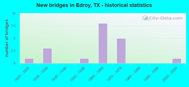
- New bridges - historical statistics
- 11920-1929
- 31930-1939
- 11950-1959
- 81960-1969
- 51970-1979
- 12000-2009


- Bridge Condition - Deck
- 42.9%Good
- 57.1%Satisfactory

- Bridge Condition - Superstructure
- 71.4%Good
- 28.6%Satisfactory

- Bridge Condition - Substructure
- 42.9%Good
- 28.6%Satisfactory
- 14.3%Fair
- 14.3%Poor

- Bridge Condition - Channel
- 14.3%Very good
- 57.1%Good
- 28.6%Satisfactory

- Bridge Condition - Culverts
- 66.7%Good
- 33.3%Satisfactory
Find on map >> Show street view
Structure Number: 162050007405038, Location: 0.1 MI W OF IH 37 (Lat: 27.972947, Lng: -97.672175), Route carried "on" structure: State highway 234, Year Built: 1937, Status: Open, Structure Length: 4.75m (15.58ft), Average Daily Traffic: 830 (year 2020), Truck Traffic: 19%, Average Future Daily Traffic: 950 (year 2033), Design Load: H 15, Features Intersected: IH 37 WFR
Minimum Vertical Clearance: 30+ m (98+ ft), Kilometerpoint: 0.950, Lanes on structure: 2, Lanes under structure: 2, Owner: State Highway Agency, Approaching Roadway Width: 7.3m (24.0ft), Skew: 3 degrees, Material/Design: Steel, Design/Construction: Stringer/Multi-beam, Number Of Spans In Main Unit: 3, Length of Maximum Span: 15.9m (52.2ft), Curb-To-Curb Width: 7.3m (24.0ft), Out-to-Out Width: 8.3m (27.2ft)
Condition: Deck: Satisfactory, Superstructure: Satisfactory, Substructure: Fair, Operating Rating: 41.7 metric tons, Method Used To Determine Operating Rating: Load Factor (LF), Inventory Rating: 25.4 metric tons, Method Used To Determine Inventory Rating: Load Factor (LF), Structural Evaluation: Somewhat better than minimum adequacy, Deck Geometry: Meets minimum limits, Underclear: High priority of corrective action, Approach Roadway Alignment: Equal to present desirable criteria, Length Of Structure Improvement: 4.75m (15.58ft), Designated Inspection Frequency: Every 24 months, Inspection Date: March 2020, Bridge Improvement Cost: $7,000, Roadway Improvement Cost: $2,000, Total Project Cost: $9,000, Deck Structure Type: Concrete Cast-file-Place, Wearing Surface/Protective System: Wearing Surface: Bituminous
Find on map >> Show street view
Structure Number: 16205000740504, Location: 0.1 MI NW OF SH 234 (Lat: 27.974186, Lng: -97.672961), Route carried "on" structure: ServiceInterstate 37, Year Built: 1937, Status: Open, Structure Length: 0.70m (2.30ft), Average Daily Traffic: 70 (year 2013), Truck Traffic: 22%, Average Future Daily Traffic: 100 (year 2033), Features Intersected: DRAIN
Minimum Vertical Clearance: 30+ m (98+ ft), Kilometerpoint: 10.020, Lanes on structure: 2, Owner: State Highway Agency, Approaching Roadway Width: 7.6m (24.9ft), Material/Design: Concrete, Design/Construction: Culvert, Number Of Spans In Main Unit: 4, Length of Maximum Span: 1.5m (4.9ft)
Condition: Channel: Good, Culverts: Satisfactory, Operating Rating: 32.7 metric tons, Method Used To Determine Operating Rating: Field evaluation and documented engineering judgment, Inventory Rating: 24.5 metric tons, Method Used To Determine Inventory Rating: Field evaluation and documented engineering judgment, Structural Evaluation: Equal to present minimum criteria, Waterway Adequacy: Equal to present minimum criteria, Approach Roadway Alignment: Equal to present desirable criteria, Length Of Structure Improvement: 0.67m (2.20ft), Designated Inspection Frequency: Every 24 months, Inspection Date: March 2020, Bridge Improvement Cost: $14,000, Roadway Improvement Cost: $4,000, Total Project Cost: $18,000
Find on map >> Show street view
Structure Number: 162050007405108, Location: 0.5 MI NW OF SH 234 (Lat: 27.979086, Lng: -97.675872), Route carried "on" structure: State highway 796, Year Built: 1969, Status: Open, Structure Length: 10.67m (35.01ft), Average Daily Traffic: 260 (year 2013), Truck Traffic: 1%, Average Future Daily Traffic: 360 (year 2033), Design Load: H 20, Features Intersected: IH 37
Minimum Vertical Clearance: 30+ m (98+ ft), Kilometerpoint: 13.573, Lanes on structure: 2, Lanes under structure: 4, Owner: State Highway Agency, Approaching Roadway Width: 7.3m (24.0ft), Skew: 3 degrees, Material/Design: Prestressed concrete, Design/Construction: Stringer/Multi-beam, Number Of Spans In Main Unit: 4, Length of Maximum Span: 30.5m (100.1ft), Curb-To-Curb Width: 10.0m (32.8ft), Out-to-Out Width: 10.8m (35.4ft)
Condition: Deck: Satisfactory, Superstructure: Good, Substructure: Satisfactory, Operating Rating: 62.6 metric tons, Method Used To Determine Operating Rating: Load Factor (LF), Inventory Rating: 23.6 metric tons, Method Used To Determine Inventory Rating: Load Factor (LF), Structural Evaluation: Equal to present minimum criteria, Deck Geometry: Better than present minimum criteria, Underclear: Meets minimum limits, Approach Roadway Alignment: Equal to present desirable criteria, Designated Inspection Frequency: Every 24 months, Inspection Date: March 2020, Deck Structure Type: Concrete Cast-file-Place
Find on map >> Show street view
Structure Number: 162050007405109, Location: 5.4 MI NW OF US 77 (Lat: 27.972792, Lng: -97.671150), Route carried "on" structure: Interstate 37, Year Built: 1969, Status: Open, Structure Length: 10.36m (33.99ft), Average Daily Traffic: 12,548 (year 2019), Truck Traffic: 20%, Average Future Daily Traffic: 18,460 (year 2033), Design Load: HS 20, Features Intersected: SH 234 & UPRR
Minimum Vertical Clearance: 30+ m (98+ ft), Kilometerpoint: 9.757, Lanes on structure: 3, Lanes under structure: 2, Base Highway Network: Yes, Owner: State Highway Agency, Approaching Roadway Width: 11.6m (38.1ft), Skew: 3 degrees, Material/Design: Prestressed concrete, Design/Construction: Stringer/Multi-beam, Number Of Spans In Main Unit: 2, Number Of Approach Spans: 3, Length of Maximum Span: 24.4m (80.1ft), Curb-To-Curb Width: 12.4m (40.7ft), Out-to-Out Width: 12.9m (42.3ft)
Condition: Deck: Good, Superstructure: Good, Substructure: Good, Operating Rating: 68.0 metric tons, Method Used To Determine Operating Rating: Load Factor (LF), Inventory Rating: 27.2 metric tons, Method Used To Determine Inventory Rating: Load Factor (LF), Structural Evaluation: Equal to present minimum criteria, Deck Geometry: Meets minimum limits, Underclear: Somewhat better than minimum adequacy, Approach Roadway Alignment: Equal to present desirable criteria, Designated Inspection Frequency: Every 24 months, Inspection Date: March 2020, Deck Structure Type: Concrete Cast-file-Place, Wearing Surface/Protective System: Wearing Surface: Bituminous
Find on map >> Show street view
Structure Number: 16205000740511, Location: 5.4 MI NW OF US 77 (Lat: 27.972811, Lng: -97.671303), Route carried "on" structure: Interstate 37, Year Built: 1969, Status: Open, Structure Length: 10.36m (33.99ft), Average Daily Traffic: 14,274 (year 2019), Truck Traffic: 20%, Average Future Daily Traffic: 18,460 (year 2033), Design Load: HS 20, Features Intersected: SH 234 & UPRR
Minimum Vertical Clearance: 30+ m (98+ ft), Kilometerpoint: 9.782, Lanes on structure: 2, Lanes under structure: 2, Base Highway Network: Yes, Owner: State Highway Agency, Approaching Roadway Width: 11.6m (38.1ft), Skew: 3 degrees, Material/Design: Prestressed concrete, Design/Construction: Stringer/Multi-beam, Number Of Spans In Main Unit: 2, Number Of Approach Spans: 3, Length of Maximum Span: 24.4m (80.1ft), Curb-To-Curb Width: 12.4m (40.7ft), Out-to-Out Width: 12.9m (42.3ft)
Condition: Deck: Good, Superstructure: Good, Substructure: Good, Operating Rating: 68.0 metric tons, Method Used To Determine Operating Rating: Load Factor (LF), Inventory Rating: 27.2 metric tons, Method Used To Determine Inventory Rating: Load Factor (LF), Structural Evaluation: Equal to present minimum criteria, Deck Geometry: Better than present minimum criteria, Underclear: Somewhat better than minimum adequacy, Approach Roadway Alignment: Equal to present desirable criteria, Designated Inspection Frequency: Every 24 months, Inspection Date: March 2020, Deck Structure Type: Concrete Cast-file-Place, Wearing Surface/Protective System: Wearing Surface: Bituminous
Find on map >> Show street view
Structure Number: 162050007405111, Location: 3.4 MI NW OF US 77 (Lat: 27.947936, Lng: -97.656150), Route carried "on" structure: County highway 1726, Year Built: 1969, Status: Open, Structure Length: 12.19m (39.99ft), Average Daily Traffic: 200 (year 2011), Average Future Daily Traffic: 300 (year 2031), Design Load: H 15, Features Intersected: IH 37
Minimum Vertical Clearance: 30+ m (98+ ft), Kilometerpoint: 0.483, Lanes on structure: 2, Lanes under structure: 8, Owner: State Highway Agency, Approaching Roadway Width: 7.3m (24.0ft), Material/Design: Prestressed concrete, Design/Construction: Stringer/Multi-beam, Number Of Spans In Main Unit: 4, Number Of Approach Spans: 2, Length of Maximum Span: 24.4m (80.1ft), Curb-To-Curb Width: 7.9m (25.9ft), Out-to-Out Width: 8.6m (28.2ft)
Condition: Deck: Good, Superstructure: Good, Substructure: Good, Operating Rating: 55.3 metric tons, Method Used To Determine Operating Rating: Load Factor (LF), Inventory Rating: 19.0 metric tons, Method Used To Determine Inventory Rating: Load Factor (LF), Structural Evaluation: Somewhat better than minimum adequacy, Deck Geometry: Somewhat better than minimum adequacy, Underclear: Equal to present minimum criteria, Approach Roadway Alignment: Equal to present minimum criteria, Length Of Structure Improvement: 12.19m (39.99ft), Designated Inspection Frequency: Every 24 months, Inspection Date: March 2020, Deck Structure Type: Concrete Cast-file-Place
Find on map >> Show street view
Structure Number: 162050007405113, Location: 1.2 MI N OF FM 796 (Lat: 27.991003, Lng: -97.691389), Route carried "on" structure: Interstate 37, Year Built: 1970, Status: Open, Structure Length: 1.28m (4.20ft), Average Daily Traffic: 25,741 (year 2019), Truck Traffic: 20%, Average Future Daily Traffic: 32,690 (year 2033), Design Load: HS 20, Features Intersected: DRAW
Minimum Vertical Clearance: 30+ m (98+ ft), Kilometerpoint: 12.675, Lanes on structure: 6, Owner: State Highway Agency, Approaching Roadway Width: 30.8m (101.0ft), Skew: 20 degrees, Material/Design: Concrete, Design/Construction: Culvert, Number Of Spans In Main Unit: 5, Length of Maximum Span: 2.4m (7.9ft)
Condition: Channel: Satisfactory, Culverts: Good, Operating Rating: 39.9 metric tons, Method Used To Determine Operating Rating: Load Factor (LF), Inventory Rating: 23.6 metric tons, Method Used To Determine Inventory Rating: Load Factor (LF), Structural Evaluation: Somewhat better than minimum adequacy, Waterway Adequacy: Equal to present minimum criteria, Approach Roadway Alignment: Equal to present desirable criteria, Length Of Structure Improvement: 1.28m (4.20ft), Designated Inspection Frequency: Every 24 months, Inspection Date: March 2020, Bridge Improvement Cost: $32,000, Roadway Improvement Cost: $8,000, Total Project Cost: $40,000
Find on map >> Show street view
Structure Number: 162050007405114, Location: 1.2 MI N OF FM 796 (Lat: 27.990486, Lng: -97.691917), Route carried "on" structure: ServiceInterstate 37, Year Built: 1970, Status: Open, Structure Length: 1.49m (4.89ft), Average Daily Traffic: 60 (year 2013), Average Future Daily Traffic: 80 (year 2033), Design Load: HS 20, Features Intersected: DRAW
Minimum Vertical Clearance: 30+ m (98+ ft), Kilometerpoint: 12.675, Lanes on structure: 2, Owner: State Highway Agency, Approaching Roadway Width: 6.7m (22.0ft), Skew: 3 degrees, Material/Design: Concrete, Design/Construction: Culvert, Number Of Spans In Main Unit: 5, Length of Maximum Span: 2.4m (7.9ft)
Condition: Channel: Good, Culverts: Good, Operating Rating: 39.9 metric tons, Method Used To Determine Operating Rating: Load Factor (LF), Inventory Rating: 23.6 metric tons, Method Used To Determine Inventory Rating: Load Factor (LF), Structural Evaluation: Equal to present minimum criteria, Waterway Adequacy: Better than present minimum criteria, Approach Roadway Alignment: Equal to present desirable criteria, Designated Inspection Frequency: Every 24 months, Inspection Date: March 2020
Find on map >> Show street view
Structure Number: 162050007405115, Location: 2.25 MI N OF FM 796 (Lat: 28.000744, Lng: -97.704092), Route carried "on" structure: ServiceInterstate 37, Year Built: 1970, Status: Open, Structure Length: 0.70m (2.30ft), Average Daily Traffic: 19 (year 2011), Average Future Daily Traffic: 70 (year 2031), Design Load: HS 20, Features Intersected: DRAIN
Minimum Vertical Clearance: 30+ m (98+ ft), Kilometerpoint: 14.410, Lanes on structure: 2, Owner: State Highway Agency, Approaching Roadway Width: 6.1m (20.0ft), Skew: 4 degrees, Material/Design: Concrete, Design/Construction: Culvert, Number Of Spans In Main Unit: 3, Length of Maximum Span: 1.5m (4.9ft), Curb-To-Curb Width: 6.1m (20.0ft), Out-to-Out Width: 12.9m (42.3ft)
Condition: Channel: Very good, Culverts: Good, Operating Rating: 39.9 metric tons, Method Used To Determine Operating Rating: Load Factor (LF), Inventory Rating: 23.6 metric tons, Method Used To Determine Inventory Rating: Load Factor (LF), Structural Evaluation: Equal to present minimum criteria, Deck Geometry: Somewhat better than minimum adequacy, Waterway Adequacy: Meets minimum limits, Approach Roadway Alignment: Equal to present desirable criteria, Length Of Structure Improvement: 0.70m (2.30ft), Designated Inspection Frequency: Every 24 months, Inspection Date: March 2020, Bridge Improvement Cost: $1,000, Total Project Cost: $1,000, Deck Structure Type: Concrete Cast-file-Place, Wearing Surface/Protective System: Wearing Surface: Bituminous
Find on map >> Show street view
Structure Number: 162050007405116, Location: 2.4 MI N OF FM 796 (Lat: 28.002369, Lng: -97.705317), Route carried "on" structure: County highway 21, Year Built: 1970, Status: Open, Structure Length: 13.56m (44.49ft), Average Daily Traffic: 200 (year 2011), Average Future Daily Traffic: 500 (year 2031), Design Load: HS 20, Features Intersected: IH 37
Minimum Vertical Clearance: 30+ m (98+ ft), Kilometerpoint: 0.805, Lanes on structure: 2, Lanes under structure: 8, Owner: State Highway Agency, Approaching Roadway Width: 8.5m (27.9ft), Material/Design: Prestressed concrete, Design/Construction: Stringer/Multi-beam, Number Of Spans In Main Unit: 4, Number Of Approach Spans: 2, Length of Maximum Span: 29.0m (95.1ft), Curb-To-Curb Width: 10.4m (34.1ft), Out-to-Out Width: 11.0m (36.1ft)
Condition: Deck: Satisfactory, Superstructure: Good, Substructure: Satisfactory, Operating Rating: 68.0 metric tons, Method Used To Determine Operating Rating: Load Factor (LF), Inventory Rating: 28.1 metric tons, Method Used To Determine Inventory Rating: Load Factor (LF), Structural Evaluation: Equal to present minimum criteria, Deck Geometry: Better than present minimum criteria, Underclear: Somewhat better than minimum adequacy, Approach Roadway Alignment: Equal to present desirable criteria, Designated Inspection Frequency: Every 24 months, Inspection Date: March 2020, Deck Structure Type: Concrete Cast-file-Place
Find on map >> Show street view
Structure Number: 162050202601001, Location: 1.65 MI N OF IH 37 (Lat: 28.002967, Lng: -97.673342), Route carried "on" structure: State highway 796, Year Built: 1955, Status: Open, Structure Length: 1.52m (4.99ft), Average Daily Traffic: 292 (year 2020), Truck Traffic: 1%, Average Future Daily Traffic: 360 (year 2033), Design Load: H 15, Features Intersected: DRAW
Minimum Vertical Clearance: 30+ m (98+ ft), Kilometerpoint: 10.969, Lanes on structure: 2, Owner: State Highway Agency, Approaching Roadway Width: 6.7m (22.0ft), Material/Design: Concrete, Design/Construction: Slab, Number Of Spans In Main Unit: 2, Length of Maximum Span: 7.6m (24.9ft), Curb-To-Curb Width: 7.1m (23.3ft), Out-to-Out Width: 7.7m (25.3ft)
Condition: Deck: Satisfactory, Superstructure: Satisfactory, Substructure: Poor, Channel: Satisfactory, Operating Rating: 51.7 metric tons, Method Used To Determine Operating Rating: Load Factor (LF), Inventory Rating: 27.2 metric tons, Method Used To Determine Inventory Rating: Load Factor (LF), Structural Evaluation: Meets minimum limits, Deck Geometry: Meets minimum limits, Waterway Adequacy: Better than present minimum criteria, Approach Roadway Alignment: Equal to present desirable criteria, Designated Inspection Frequency: Every 24 months, Inspection Date: March 2020, Deck Structure Type: Concrete Cast-file-Place
Find on map >> Show street view
Structure Number: 162050AA0178001, Location: 0.70 MI W OF SH 234 (Lat: 27.975500, Lng: -97.687656), Route carried "on" structure: County highway 1168, Year Built: 1925, Status: Open, Structure Length: 1.37m (4.49ft), Average Daily Traffic: 300 (year 2015), Average Future Daily Traffic: 400 (year 2035), Features Intersected: HONDO CREEK
Minimum Vertical Clearance: 30+ m (98+ ft), Kilometerpoint: 1.046, Lanes on structure: 2, Owner: County Highway Agency, Approaching Roadway Width: 6.1m (20.0ft), Material/Design: Concrete, Design/Construction: Culvert, Number Of Spans In Main Unit: 4, Length of Maximum Span: 3.4m (11.2ft), Curb-To-Curb Width: 7.4m (24.3ft), Out-to-Out Width: 7.8m (25.6ft)
Condition: Channel: Good, Culverts: Satisfactory, Operating Rating: 39.9 metric tons, Method Used To Determine Operating Rating: Load Factor (LF), Inventory Rating: 23.6 metric tons, Method Used To Determine Inventory Rating: Load Factor (LF), Structural Evaluation: Equal to present minimum criteria, Deck Geometry: Somewhat better than minimum adequacy, Waterway Adequacy: Better than present minimum criteria, Approach Roadway Alignment: Equal to present desirable criteria, Designated Inspection Frequency: Every 24 months, Inspection Date: June 2021, Deck Structure Type: Concrete Cast-file-Place, Wearing Surface/Protective System: Wearing Surface: Bituminous
Find on map >> Show street view
Structure Number: 162050AA0214001, Location: 1.4 MI W OF IH 37 (Lat: 27.951164, Lng: -97.677186), Route carried "on" structure: County highway 1726, Year Built: 2002, Status: Open, Structure Length: 1.83m (6.00ft), Average Daily Traffic: 410 (year 2015), Average Future Daily Traffic: 500 (year 2035), Design Load: HS 20, Features Intersected: HONDO CREEK
Minimum Vertical Clearance: 30+ m (98+ ft), Kilometerpoint: 2.012, Lanes on structure: 2, Owner: County Highway Agency, Approaching Roadway Width: 6.1m (20.0ft), Material/Design: Concrete, Design/Construction: Culvert, Number Of Spans In Main Unit: 5, Length of Maximum Span: 3.0m (9.8ft), Curb-To-Curb Width: 9.1m (29.9ft), Out-to-Out Width: 9.8m (32.2ft)
Condition: Channel: Good, Culverts: Good, Operating Rating: 54.4 metric tons, Method Used To Determine Operating Rating: Assigned rating based on Load Factor Design (LFD) reported in metric tons, Inventory Rating: 32.7 metric tons, Method Used To Determine Inventory Rating: Assigned rating based on Load Factor Design (LFD) reported in metric tons, Structural Evaluation: Better than present minimum criteria, Deck Geometry: Equal to present minimum criteria, Waterway Adequacy: Better than present minimum criteria, Approach Roadway Alignment: Equal to present desirable criteria, Length Of Structure Improvement: 1.80m (5.91ft), Designated Inspection Frequency: Every 24 months, Inspection Date: June 2021, Deck Structure Type: Concrete Precast Panels, Wearing Surface/Protective System: Wearing Surface: Bituminous
Find on map >> Show street view
Structure Number: 162050007405038, Location: 0.1 MI W OF IH 37 (Lat: 27.972947, Lng: -97.672175), Route carried "under" structure: ServiceInterstate 37, Year Built: 1937, Structure Length: 0. m, Average Daily Traffic: 70 (year 2013), Truck Traffic: 22%, Features Intersected: IH 37 WFR, Facility Carried by Structure: SH 234
Minimum Vertical Clearance: 4.22m (13.85ft), Kilometerpoint: 9.814, Lanes on structure: 2, Lanes under structure: 2, Material/Design: Steel, Design/Construction: Stringer/Multi-beam, Length of Maximum Span: 15.9m (52.2ft)
Find on map >> Show street view
Structure Number: 162050007405108, Location: 0.5 MI NW OF SH 234 (Lat: 27.979086, Lng: -97.675872), Route carried "under" structure: Interstate 37, Year Built: 1969, Structure Length: 0. m, Average Daily Traffic: 26,370 (year 2013), Truck Traffic: 20%, Features Intersected: IH 37, Facility Carried by Structure: FM 796
Minimum Vertical Clearance: 5.33m (17.49ft), Kilometerpoint: 10.680, Lanes on structure: 2, Lanes under structure: 4, Material/Design: Prestressed concrete, Design/Construction: Stringer/Multi-beam, Length of Maximum Span: 30.5m (100.1ft)
Find on map >> Show street view
Structure Number: 162050007405109, Location: 5.4 MI NW OF US 77 (Lat: 27.972792, Lng: -97.671150), Route carried "under" structure: State highway 234, Year Built: 1969, Structure Length: 0. m, Average Daily Traffic: 680 (year 2013), Truck Traffic: 19%, Features Intersected: SH 234 & UPRR, Facility Carried by Structure: IH 37 NB
Minimum Vertical Clearance: 6.81m (22.34ft), Kilometerpoint: 1.053, Lanes on structure: 3, Lanes under structure: 2, Material/Design: Prestressed concrete, Design/Construction: Stringer/Multi-beam, Length of Maximum Span: 24.4m (80.1ft)
Find on map >> Show street view
Structure Number: 16205000740511, Location: 5.4 MI NW OF US 77 (Lat: 27.972811, Lng: -97.671303), Route carried "under" structure: State highway 234, Year Built: 1969, Structure Length: 0. m, Average Daily Traffic: 840 (year 2013), Truck Traffic: 19%, Features Intersected: SH 234 & UPRR, Facility Carried by Structure: IH 37 SB
Minimum Vertical Clearance: 6.78m (22.24ft), Kilometerpoint: 1.093, Lanes on structure: 2, Lanes under structure: 3, Material/Design: Prestressed concrete, Design/Construction: Stringer/Multi-beam, Length of Maximum Span: 24.4m (80.1ft)
Find on map >> Show street view
Structure Number: 162050007405111, Location: 3.4 MI NW OF US 77 (Lat: 27.947936, Lng: -97.656150), Route carried "under" structure: Interstate 37, Year Built: 1969, Structure Length: 0. m, Average Daily Traffic: 26,370 (year 2013), Truck Traffic: 20%, Features Intersected: IH 37, Facility Carried by Structure: CR 1726-COOPER RD
Minimum Vertical Clearance: 5.31m (17.42ft), Kilometerpoint: 6.795, Lanes under structure: 8, Material/Design: Prestressed concrete, Design/Construction: Stringer/Multi-beam, Length of Maximum Span: 24.4m (80.1ft)
Find on map >> Show street view
Structure Number: 162050007405116, Location: 2.4 MI N OF FM 796 (Lat: 28.002369, Lng: -97.705317), Route carried "under" structure: Interstate 37, Year Built: 1970, Structure Length: 0. m, Average Daily Traffic: 23,350 (year 2013), Truck Traffic: 20%, Features Intersected: IH 37, Facility Carried by Structure: CR 21
Minimum Vertical Clearance: 5.69m (18.67ft), Kilometerpoint: 14.548, Lanes on structure: 2, Lanes under structure: 8, Material/Design: Prestressed concrete, Design/Construction: Stringer/Multi-beam, Length of Maximum Span: 29.0m (95.1ft)