Bridge Statistics for Eldred, Illinois (IL)
Condition, Traffic, Stress, Structural Evaluation, Project Costs
- National Bridge Inventory (NBI) Statistics
- 13Number of bridges
- 66ft / 20.0mTotal length
- $154,000Total costs
- 4,350Total average daily traffic
- 717Total average daily truck traffic
- 4,660Total future (year 2032) average daily traffic
- National Bridge Inventory (NBI) Registered Bridges for Eldred
- No street view available for this location
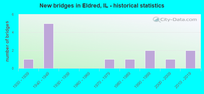
- New bridges - historical statistics
- 11930-1939
- 51940-1949
- 11970-1979
- 11980-1989
- 21990-1999
- 12000-2009
- 22010-2019
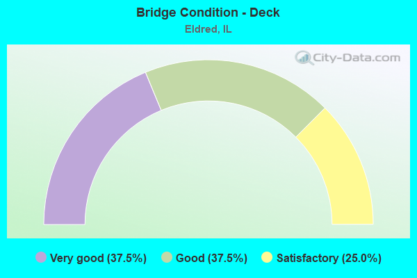
- Bridge Condition - Deck
- 37.5%Very good
- 37.5%Good
- 25.0%Satisfactory
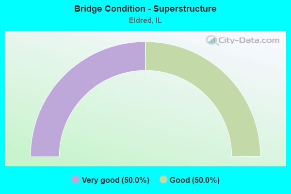
- Bridge Condition - Superstructure
- 50.0%Very good
- 50.0%Good
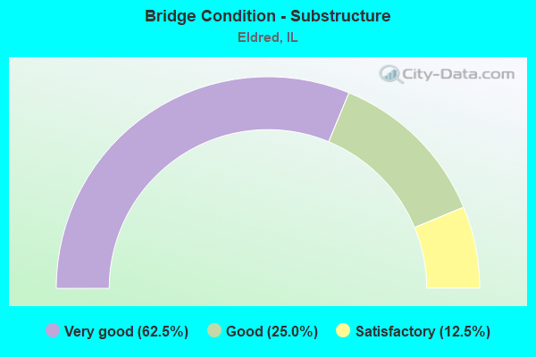
- Bridge Condition - Substructure
- 62.5%Very good
- 25.0%Good
- 12.5%Satisfactory
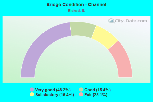
- Bridge Condition - Channel
- 46.2%Very good
- 15.4%Good
- 15.4%Satisfactory
- 23.1%Fair
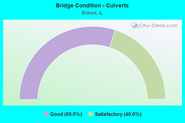
- Bridge Condition - Culverts
- 60.0%Good
- 40.0%Satisfactory
Find on map >> Show street view
Structure Number: 310012, Location: 0.2 M S JCT 108 (Lat: 39.283978, Lng: -90.551617), Route carried "on" structure: County highway , Year Built: 1946, Year Reconstructed: 1992, Status: Open, Structure Length: 3.00m (9.84ft), Average Daily Traffic: 675 (year 2017), Truck Traffic: 16%, Average Future Daily Traffic: 650 (year 2032), Design Load: HS 20, Features Intersected: HURRICANE CREEK, Facility Carried by Structure: Hillview Eldred Rd
Minimum Vertical Clearance: 30+ m (98+ ft), Kilometerpoint: 27.374, Lanes on structure: 2, Owner: State Highway Agency, Approaching Roadway Width: 10.1m (33.1ft), Skew: 2 degrees, Material/Design: Steel continuous, Design/Construction: Stringer/Multi-beam, Number Of Spans In Main Unit: 3, Length of Maximum Span: 11.2m (36.7ft), Curb-To-Curb Width: 9.8m (32.2ft), Out-to-Out Width: 10.7m (35.1ft)
Condition: Deck: Satisfactory, Superstructure: Good, Substructure: Good, Channel: Very good, Operating Rating: 63.2 metric tons, Method Used To Determine Operating Rating: Load Factor (LF) rating reported by rating factor (RF) method using MS18 loading, Inventory Rating: 37.9 metric tons, Method Used To Determine Inventory Rating: Load Factor (LF) rating reported by rating factor (RF) method using MS18 loading, Structural Evaluation: Better than present minimum criteria, Deck Geometry: Equal to present minimum criteria, Waterway Adequacy: Better than present minimum criteria, Approach Roadway Alignment: Equal to present desirable criteria, Designated Inspection Frequency: Every 24 months, Inspection Date: December 2021, Deck Structure Type: Concrete Cast-file-Place, Wearing Surface/Protective System: Deck Protection: Epoxy Coated Reinforcing
Find on map >> Show street view
Structure Number: 310038, Location: 1.1 MI W FAS 739 (Lat: 39.292739, Lng: -90.568997), Route carried "on" structure: State highway 108, Year Built: 1999, Status: Open, Structure Length: 2.58m (8.46ft), Average Daily Traffic: 450 (year 2021), Truck Traffic: 16%, Average Future Daily Traffic: 600 (year 2032), Design Load: HS 20, Features Intersected: HURRICANE CREEK
Minimum Vertical Clearance: 30+ m (98+ ft), Kilometerpoint: 3.444, Lanes on structure: 2, Base Highway Network: Yes, Owner: State Highway Agency, Approaching Roadway Width: 7.2m (23.6ft), Material/Design: Steel, Design/Construction: Stringer/Multi-beam, Number Of Spans In Main Unit: 1, Length of Maximum Span: 25.0m (82.0ft), Curb-To-Curb Width: 9.6m (31.5ft), Out-to-Out Width: 10.6m (34.8ft)
Condition: Deck: Very good, Superstructure: Very good, Substructure: Very good, Channel: Very good, Operating Rating: 69.3 metric tons, Method Used To Determine Operating Rating: Load Factor (LF) rating reported by rating factor (RF) method using MS18 loading, Inventory Rating: 41.8 metric tons, Method Used To Determine Inventory Rating: Load Factor (LF) rating reported by rating factor (RF) method using MS18 loading, Structural Evaluation: Equal to present desirable criteria, Deck Geometry: Equal to present minimum criteria, Waterway Adequacy: Better than present minimum criteria, Approach Roadway Alignment: Equal to present desirable criteria, Designated Inspection Frequency: Every 48 months, Inspection Date: June 2020, Deck Structure Type: Concrete Cast-file-Place, Wearing Surface/Protective System: Deck Protection: Epoxy Coated Reinforcing
Find on map >> Show street view
Structure Number: 310041, Location: 2.2 M S JCT 108 (Lat: 39.256514, Lng: -90.555161), Route carried "on" structure: County highway , Year Built: 2011, Status: Open, Structure Length: 2.56m (8.40ft), Average Daily Traffic: 575 (year 2017), Truck Traffic: 19%, Average Future Daily Traffic: 650 (year 2032), Design Load: HS 20, Features Intersected: COLE CREEK, Facility Carried by Structure: Hillview Eldred Ro
Minimum Vertical Clearance: 30+ m (98+ ft), Kilometerpoint: 30.641, Lanes on structure: 2, Owner: State Highway Agency, Approaching Roadway Width: 6.7m (22.0ft), Material/Design: Steel continuous, Design/Construction: Stringer/Multi-beam, Number Of Spans In Main Unit: 1, Length of Maximum Span: 24.8m (81.4ft), Curb-To-Curb Width: 8.5m (27.9ft), Out-to-Out Width: 9.5m (31.2ft)
Condition: Deck: Satisfactory, Superstructure: Very good, Substructure: Very good, Channel: Very good, Operating Rating: 74.5 metric tons, Method Used To Determine Operating Rating: Load and Resistance Factor Rating (LRFR) rating reported by rating factor(RF) method using HL-93 loadings, Inventory Rating: 57.3 metric tons, Method Used To Determine Inventory Rating: Load and Resistance Factor Rating (LRFR) rating reported by rating factor(RF) method using HL-93 loadings, Structural Evaluation: Equal to present desirable criteria, Deck Geometry: Somewhat better than minimum adequacy, Waterway Adequacy: Equal to present desirable criteria, Approach Roadway Alignment: Equal to present desirable criteria, Designated Inspection Frequency: Every 48 months, Inspection Date: December 2021, Deck Structure Type: Concrete Cast-file-Place, Wearing Surface/Protective System: Deck Protection: Epoxy Coated Reinforcing
Find on map >> Show street view
Structure Number: 312001, Location: 2.5 N ELDRED (Lat: 39.322386, Lng: -90.550933), Route carried "on" structure: County highway , Year Built: 1939, Status: Posted for load, Structure Length: 0.82m (2.69ft), Average Daily Traffic: 425 (year 2017), Truck Traffic: 16%, Average Future Daily Traffic: 400 (year 2032), Features Intersected: CREEK, Facility Carried by Structure: Hillview Eldred Ro
Minimum Vertical Clearance: 30+ m (98+ ft), Kilometerpoint: 23.270, Lanes on structure: 2, Owner: State Highway Agency, Approaching Roadway Width: 6.7m (22.0ft), Material/Design: Concrete continuous, Design/Construction: Culvert, Number Of Spans In Main Unit: 2, Length of Maximum Span: 3.7m (12.1ft)
Condition: Channel: Fair, Culverts: Good, Operating Rating: 27.5 metric tons, Method Used To Determine Operating Rating: Load Factor (LF) rating reported by rating factor (RF) method using MS18 loading, Inventory Rating: 16.5 metric tons, Method Used To Determine Inventory Rating: Load Factor (LF) rating reported by rating factor (RF) method using MS18 loading, Structural Evaluation: Somewhat better than minimum adequacy, Waterway Adequacy: Equal to present minimum criteria, Approach Roadway Alignment: Equal to present desirable criteria, Bridge Posting: Required (Relationship of Operating Rating to Maximum Legal Load: 30.0 - 39.9% below), Length Of Structure Improvement: 0.82m (2.69ft), Designated Inspection Frequency: Every 12 months, Inspection Date: December 2021, Bridge Improvement Cost: $70,000, Roadway Improvement Cost: $7,000, Total Project Cost: $77,000
Find on map >> Show street view
Structure Number: 312002, Location: 3.5 S ELDRED (Lat: 39.233986, Lng: -90.555147), Route carried "on" structure: County highway , Year Built: 1946, Status: Posted for load, Structure Length: 0.77m (2.53ft), Average Daily Traffic: 550 (year 2017), Truck Traffic: 16%, Average Future Daily Traffic: 550 (year 2032), Design Load: H 15, Features Intersected: Dayton Hollow Creek, Facility Carried by Structure: Hillview/Eldred Ro
Minimum Vertical Clearance: 30+ m (98+ ft), Kilometerpoint: 33.168, Lanes on structure: 2, Owner: State Highway Agency, Approaching Roadway Width: 6.7m (22.0ft), Skew: 1 degrees, Material/Design: Concrete continuous, Design/Construction: Culvert, Number Of Spans In Main Unit: 2, Length of Maximum Span: 3.4m (11.2ft)
Condition: Channel: Satisfactory, Culverts: Satisfactory, Operating Rating: 35.3 metric tons, Method Used To Determine Operating Rating: Load Factor (LF) rating reported by rating factor (RF) method using MS18 loading, Inventory Rating: 21.1 metric tons, Method Used To Determine Inventory Rating: Load Factor (LF) rating reported by rating factor (RF) method using MS18 loading, Structural Evaluation: Somewhat better than minimum adequacy, Waterway Adequacy: Equal to present desirable criteria, Approach Roadway Alignment: Equal to present desirable criteria, Bridge Posting: Required (Relationship of Operating Rating to Maximum Legal Load: 20.0 - 29.9% below), Designated Inspection Frequency: Every 12 months, Inspection Date: December 2021
Find on map >> Show street view
Structure Number: 312008, Location: 0.51 N OF ELDRED (Lat: 39.296189, Lng: -90.549228), Route carried "on" structure: County highway , Year Built: 1940, Status: Posted for load, Structure Length: 0.69m (2.26ft), Average Daily Traffic: 425 (year 2017), Truck Traffic: 16%, Average Future Daily Traffic: 400 (year 2032), Features Intersected: Shaffer Hollow Creek, Facility Carried by Structure: Hillview Eldred Ro
Minimum Vertical Clearance: 30+ m (98+ ft), Kilometerpoint: 26.167, Lanes on structure: 2, Owner: State Highway Agency, Approaching Roadway Width: 6.7m (22.0ft), Material/Design: Concrete continuous, Design/Construction: Culvert, Number Of Spans In Main Unit: 2, Length of Maximum Span: 3.0m (9.8ft)
Condition: Channel: Good, Culverts: Good, Operating Rating: 32.1 metric tons, Method Used To Determine Operating Rating: Load Factor (LF) rating reported by rating factor (RF) method using MS18 loading, Inventory Rating: 19.1 metric tons, Method Used To Determine Inventory Rating: Load Factor (LF) rating reported by rating factor (RF) method using MS18 loading, Structural Evaluation: Somewhat better than minimum adequacy, Waterway Adequacy: Equal to present minimum criteria, Approach Roadway Alignment: Equal to present minimum criteria, Bridge Posting: Required (Relationship of Operating Rating to Maximum Legal Load: > 39.9% below), Length Of Structure Improvement: 0.67m (2.20ft), Designated Inspection Frequency: Every 12 months, Inspection Date: December 2021, Bridge Improvement Cost: $70,000, Roadway Improvement Cost: $7,000, Total Project Cost: $77,000
Find on map >> Show street view
Structure Number: 312009, Location: 1.08 S OF ELDRED (Lat: 39.270144, Lng: -90.554325), Route carried "on" structure: County highway , Year Built: 1940, Status: Open, Structure Length: 0.92m (3.02ft), Average Daily Traffic: 675 (year 2017), Truck Traffic: 16%, Average Future Daily Traffic: 700 (year 2032), Design Load: H 15, Features Intersected: Bushnell Hollow, Facility Carried by Structure: Hillview Eldred Ro
Minimum Vertical Clearance: 30+ m (98+ ft), Kilometerpoint: 29.112, Lanes on structure: 2, Owner: State Highway Agency, Approaching Roadway Width: 6.9m (22.6ft), Skew: 4 degrees, Material/Design: Concrete continuous, Design/Construction: Culvert, Number Of Spans In Main Unit: 2, Length of Maximum Span: 4.1m (13.5ft)
Condition: Channel: Good, Culverts: Satisfactory, Operating Rating: 61.6 metric tons, Method Used To Determine Operating Rating: Load Factor (LF) rating reported by rating factor (RF) method using MS18 loading, Inventory Rating: 36.9 metric tons, Method Used To Determine Inventory Rating: Load Factor (LF) rating reported by rating factor (RF) method using MS18 loading, Structural Evaluation: Equal to present minimum criteria, Waterway Adequacy: Equal to present minimum criteria, Approach Roadway Alignment: Equal to present desirable criteria, Designated Inspection Frequency: Every 24 months, Inspection Date: December 2021
Find on map >> Show street view
Structure Number: 31201, Location: 2.7 M N OF ELDRED (Lat: 39.327275, Lng: -90.550725), Route carried "on" structure: County highway , Year Built: 1940, Status: Open, Structure Length: 0.71m (2.33ft), Average Daily Traffic: 425 (year 2017), Truck Traffic: 16%, Average Future Daily Traffic: 400 (year 2032), Features Intersected: Robley Hollow, Facility Carried by Structure: Hillview Eldred Ro
Minimum Vertical Clearance: 30+ m (98+ ft), Kilometerpoint: 22.691, Lanes on structure: 2, Owner: State Highway Agency, Approaching Roadway Width: 6.9m (22.6ft), Skew: 1 degrees, Material/Design: Concrete continuous, Design/Construction: Culvert, Number Of Spans In Main Unit: 2, Length of Maximum Span: 3.2m (10.5ft)
Condition: Channel: Fair, Culverts: Good, Operating Rating: 60.6 metric tons, Method Used To Determine Operating Rating: Load Factor (LF) rating reported by rating factor (RF) method using MS18 loading, Inventory Rating: 36.3 metric tons, Method Used To Determine Inventory Rating: Load Factor (LF) rating reported by rating factor (RF) method using MS18 loading, Structural Evaluation: Better than present minimum criteria, Waterway Adequacy: Equal to present minimum criteria, Approach Roadway Alignment: Equal to present desirable criteria, Designated Inspection Frequency: Every 24 months, Inspection Date: December 2021
Find on map >> Show street view
Structure Number: 315023, Location: 2.7 M N ELDRED (Lat: 39.326931, Lng: -90.548100), Route carried "on" structure: County highway , Year Built: 1978, Status: Open, Structure Length: 0.85m (2.79ft), Average Daily Traffic: 25 (year 2017), Truck Traffic: 20%, Average Future Daily Traffic: 75 (year 2032), Features Intersected: STREAM, Facility Carried by Structure: TR 203
Minimum Vertical Clearance: 30+ m (98+ ft), Kilometerpoint: 0.241, Lanes on structure: 2, Owner: Town or Township Highway Agency, Approaching Roadway Width: 6.7m (22.0ft), Material/Design: Concrete, Design/Construction: Channel Beam, Number Of Spans In Main Unit: 1, Length of Maximum Span: 7.9m (25.9ft), Curb-To-Curb Width: 8.0m (26.2ft), Out-to-Out Width: 8.1m (26.6ft)
Condition: Deck: Good, Superstructure: Good, Substructure: Satisfactory, Channel: Satisfactory, Operating Rating: 80.7 metric tons, Method Used To Determine Operating Rating: Load Factor (LF) rating reported by rating factor (RF) method using MS18 loading, Inventory Rating: 48.3 metric tons, Method Used To Determine Inventory Rating: Load Factor (LF) rating reported by rating factor (RF) method using MS18 loading, Structural Evaluation: Equal to present minimum criteria, Deck Geometry: Equal to present minimum criteria, Waterway Adequacy: Better than present minimum criteria, Approach Roadway Alignment: Better than present minimum criteria, Designated Inspection Frequency: Every 24 months, Inspection Date: March 2021, Deck Structure Type: Concrete Precast Panels
Find on map >> Show street view
Structure Number: 315043, Location: 3.7 MI SW ELDRED (Lat: 39.233206, Lng: -90.571286), Route carried "on" structure: County highway , Year Built: 1981, Status: Open, Structure Length: 1.72m (5.64ft), Average Daily Traffic: 50 (year 2017), Truck Traffic: 16%, Average Future Daily Traffic: 10 (year 2032), Design Load: HS 20, Features Intersected: DRAINAGE DITCH, Facility Carried by Structure: TR-275
Minimum Vertical Clearance: 30+ m (98+ ft), Kilometerpoint: 0.692, Lanes on structure: 2, Owner: Town or Township Highway Agency, Approaching Roadway Width: 6.7m (22.0ft), Skew: 1 degrees, Material/Design: Prestressed concrete, Design/Construction: Box Beam or Girders - Multiple, Number Of Spans In Main Unit: 1, Length of Maximum Span: 16.4m (53.8ft), Curb-To-Curb Width: 8.2m (26.9ft), Out-to-Out Width: 8.2m (26.9ft)
Condition: Deck: Good, Superstructure: Good, Substructure: Good, Channel: Fair, Operating Rating: 60.6 metric tons, Method Used To Determine Operating Rating: Load Factor (LF) rating reported by rating factor (RF) method using MS18 loading, Inventory Rating: 36.3 metric tons, Method Used To Determine Inventory Rating: Load Factor (LF) rating reported by rating factor (RF) method using MS18 loading, Structural Evaluation: Better than present minimum criteria, Deck Geometry: Equal to present minimum criteria, Waterway Adequacy: Better than present minimum criteria, Approach Roadway Alignment: Better than present minimum criteria, Designated Inspection Frequency: Every 48 months, Inspection Date: April 2018, Deck Structure Type: Concrete Precast Panels
Find on map >> Show street view
Structure Number: 315104, Location: 1/2MI EAST ELDRED RD (Lat: 39.327728, Lng: -90.541789), Route carried "on" structure: County highway , Year Built: 1999, Status: Open, Structure Length: 1.71m (5.61ft), Average Daily Traffic: 25 (year 2017), Truck Traffic: 20%, Average Future Daily Traffic: 75 (year 2032), Design Load: HS 20, Features Intersected: UNNAMED CREEK, Facility Carried by Structure: TR 203
Minimum Vertical Clearance: 30+ m (98+ ft), Kilometerpoint: 0.805, Lanes on structure: 2, Owner: Town or Township Highway Agency, Approaching Roadway Width: 7.3m (24.0ft), Skew: 1 degrees, Material/Design: Prestressed concrete, Design/Construction: Box Beam or Girders - Multiple, Number Of Spans In Main Unit: 1, Length of Maximum Span: 16.3m (53.5ft), Curb-To-Curb Width: 7.3m (24.0ft), Out-to-Out Width: 7.3m (24.0ft)
Condition: Deck: Very good, Superstructure: Very good, Substructure: Very good, Channel: Very good, Operating Rating: 44.1 metric tons, Method Used To Determine Operating Rating: Assigned rating based on Load Factor Design (LFD) reported by rating factor (RF) using MS18 loading, Inventory Rating: 32.4 metric tons, Method Used To Determine Inventory Rating: Assigned rating based on Load Factor Design (LFD) reported by rating factor (RF) using MS18 loading, Structural Evaluation: Equal to present desirable criteria, Deck Geometry: Equal to present minimum criteria, Waterway Adequacy: Equal to present desirable criteria, Approach Roadway Alignment: Equal to present desirable criteria, Designated Inspection Frequency: Every 48 months, Inspection Date: April 2019, Deck Structure Type: Concrete Precast Panels
Find on map >> Show street view
Structure Number: 315239, Location: 2.4MI SW ELDRED (Lat: 39.259200, Lng: -90.576761), Route carried "on" structure: County highway , Year Built: 2007, Status: Open, Structure Length: 1.87m (6.14ft), Average Daily Traffic: 25 (year 2017), Truck Traffic: 20%, Average Future Daily Traffic: 75 (year 2032), Design Load: HS 20, Features Intersected: STREAM, Facility Carried by Structure: TR 257
Minimum Vertical Clearance: 30+ m (98+ ft), Kilometerpoint: 1.915, Lanes on structure: 2, Owner: Town or Township Highway Agency, Approaching Roadway Width: 5.5m (18.0ft), Skew: 1 degrees, Material/Design: Prestressed concrete, Design/Construction: Box Beam or Girders - Multiple, Number Of Spans In Main Unit: 1, Length of Maximum Span: 18.0m (59.1ft), Curb-To-Curb Width: 7.3m (24.0ft), Out-to-Out Width: 7.3m (24.0ft)
Condition: Deck: Very good, Superstructure: Very good, Substructure: Very good, Channel: Very good, Operating Rating: 44.1 metric tons, Method Used To Determine Operating Rating: Assigned rating based on Load Factor Design (LFD) reported by rating factor (RF) using MS18 loading, Inventory Rating: 32.4 metric tons, Method Used To Determine Inventory Rating: Assigned rating based on Load Factor Design (LFD) reported by rating factor (RF) using MS18 loading, Structural Evaluation: Equal to present desirable criteria, Deck Geometry: Equal to present minimum criteria, Waterway Adequacy: Equal to present desirable criteria, Approach Roadway Alignment: Equal to present desirable criteria, Designated Inspection Frequency: Every 48 months, Inspection Date: March 2021, Deck Structure Type: Concrete Precast Panels
Find on map >> Show street view
Structure Number: 315253, Location: 2.8 MI E of Eldred (Lat: 39.327064, Lng: -90.545331), Route carried "on" structure: County highway , Year Built: 2011, Status: Open, Structure Length: 1.78m (5.84ft), Average Daily Traffic: 25 (year 2017), Truck Traffic: 20%, Average Future Daily Traffic: 75 (year 2032), Design Load: HS 25 or greater, Features Intersected: Stream, Facility Carried by Structure: TR 203
Minimum Vertical Clearance: 30+ m (98+ ft), Kilometerpoint: 0.483, Lanes on structure: 2, Owner: Town or Township Highway Agency, Approaching Roadway Width: 5.5m (18.0ft), Skew: 3 degrees, Material/Design: Prestressed concrete, Design/Construction: Box Beam or Girders - Multiple, Number Of Spans In Main Unit: 1, Length of Maximum Span: 17.8m (58.4ft), Curb-To-Curb Width: 7.3m (24.0ft), Out-to-Out Width: 7.3m (24.0ft)
Condition: Deck: Good, Superstructure: Good, Substructure: Very good, Channel: Very good, Operating Rating: 44.1 metric tons, Method Used To Determine Operating Rating: Assigned rating based on Load Factor Design (LFD) reported by rating factor (RF) using MS18 loading, Inventory Rating: 32.4 metric tons, Method Used To Determine Inventory Rating: Assigned rating based on Load Factor Design (LFD) reported by rating factor (RF) using MS18 loading, Structural Evaluation: Better than present minimum criteria, Deck Geometry: Equal to present minimum criteria, Waterway Adequacy: Equal to present desirable criteria, Approach Roadway Alignment: Equal to present desirable criteria, Designated Inspection Frequency: Every 48 months, Inspection Date: September 2020, Deck Structure Type: Concrete Precast Panels