Bridge Statistics for Elma, New York (NY)
Condition, Traffic, Stress, Structural Evaluation, Project Costs
- National Bridge Inventory (NBI) Statistics
- 44Number of bridges
- 417ft / 127mTotal length
- $91,638,000Total costs
- 268,687Total average daily traffic
- 10,650Total average daily truck traffic
- National Bridge Inventory (NBI) Registered Bridges for Elma
- No street view available for this location
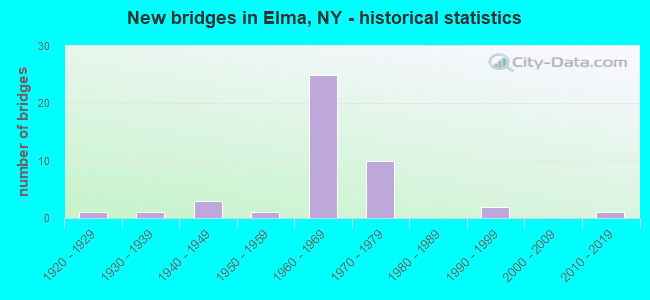
- New bridges - historical statistics
- 11920-1929
- 11930-1939
- 31940-1949
- 11950-1959
- 251960-1969
- 101970-1979
- 21990-1999
- 12010-2019
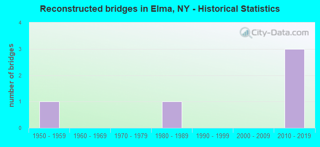
- Reconstructed bridges - Historical Statistics
- 11950-1959
- 01960-1969
- 01970-1979
- 11980-1989
- 01990-1999
- 02000-2009
- 32010-2019
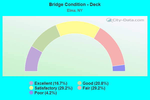
- Bridge Condition - Deck
- 16.7%Excellent
- 20.8%Good
- 29.2%Satisfactory
- 29.2%Fair
- 4.2%Poor
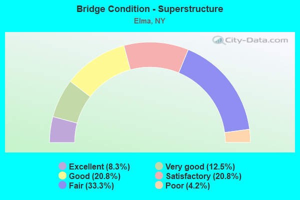
- Bridge Condition - Superstructure
- 8.3%Excellent
- 12.5%Very good
- 20.8%Good
- 20.8%Satisfactory
- 33.3%Fair
- 4.2%Poor
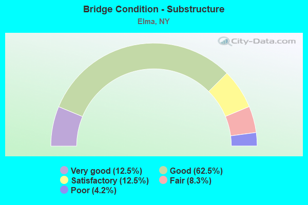
- Bridge Condition - Substructure
- 12.5%Very good
- 62.5%Good
- 12.5%Satisfactory
- 8.3%Fair
- 4.2%Poor
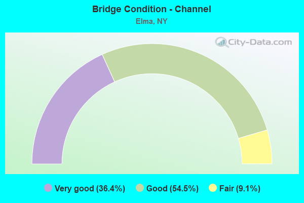
- Bridge Condition - Channel
- 36.4%Very good
- 54.5%Good
- 9.1%Fair
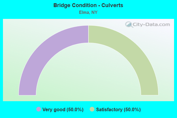
- Bridge Condition - Culverts
- 50.0%Very good
- 50.0%Satisfactory
Find on map >> Show street view
Structure Number: 10465, Location: 1.8 MI W JCT SH354& SH358 (Lat: 42.856106, Lng: -78.590625), Route carried "on" structure: State highway 354, Year Built: 1947, Year Reconstructed: 1993, Status: Open, Structure Length: 2.07m (6.79ft), Average Daily Traffic: 4,439 (year 2018), Truck Traffic: 6%, Average Future Daily Traffic: 5,492 (year 2040), Design Load: HS 20, Features Intersected: LITTLE BUFFALO CR
Minimum Vertical Clearance: 30+ m (98+ ft), Kilometerpoint: 24.232, Lanes on structure: 2, Base Highway Network: Yes, Owner: State Highway Agency, Approaching Roadway Width: 12.8m (42.0ft), Skew: 1 degrees, Material/Design: Steel, Design/Construction: Stringer/Multi-beam, Number Of Spans In Main Unit: 1, Length of Maximum Span: 20.1m (65.9ft), Curb-To-Curb Width: 11.4m (37.4ft), Out-to-Out Width: 12.0m (39.4ft)
Condition: Deck: Satisfactory, Superstructure: Satisfactory, Substructure: Poor, Channel: Good, Operating Rating: 90.7 metric tons, Method Used To Determine Operating Rating: Load Factor (LF), Inventory Rating: 53.5 metric tons, Method Used To Determine Inventory Rating: Load Factor (LF), Structural Evaluation: Meets minimum limits, Deck Geometry: Somewhat better than minimum adequacy, Waterway Adequacy: Meets minimum limits, Approach Roadway Alignment: Equal to present desirable criteria, Length Of Structure Improvement: 2.07m (6.79ft), Designated Inspection Frequency: Every 24 months, Inspection Date: October 2021, Bridge Improvement Cost: $1,480,000, Roadway Improvement Cost: $866,000, Total Project Cost: $2,346,000 ( Estimate for 2021), Deck Structure Type: Concrete Cast-file-Place, Wearing Surface/Protective System: Wearing Surface: Integral Concrete, Deck Protection: Epoxy Coated Reinforcing
Find on map >> Show street view
Structure Number: 1047531, Location: 0.5 MI SE JCT RT 400 +422 (Lat: 42.798794, Lng: -78.636542), Route carried "on" structure: State highway 400, Year Built: 1968, Status: Open, Structure Length: 4.15m (13.62ft), Average Daily Traffic: 7,775 (year 2018), Truck Traffic: 9%, Average Future Daily Traffic: 9,009 (year 2040), Design Load: HS 20, Features Intersected: BOWEN RD CR 361
Minimum Vertical Clearance: 30+ m (98+ ft), Kilometerpoint: 12.759, Lanes on structure: 2, Lanes under structure: 2, Base Highway Network: Yes, Owner: State Highway Agency, Approaching Roadway Width: 8.5m (27.9ft), Skew: 4 degrees, Material/Design: Steel, Design/Construction: Stringer/Multi-beam, Number Of Spans In Main Unit: 3, Length of Maximum Span: 16.7m (54.8ft), Curb or Sidewalk Widths: Left: 0.5m (1.6ft), Right: 0.5m (1.6ft), Curb-To-Curb Width: 8.5m (27.9ft), Out-to-Out Width: 10.1m (33.1ft)
Condition: Deck: Fair, Superstructure: Good, Substructure: Good, Operating Rating: 89.8 metric tons, Method Used To Determine Operating Rating: Load Factor (LF), Inventory Rating: 53.5 metric tons, Method Used To Determine Inventory Rating: Load Factor (LF), Structural Evaluation: Better than present minimum criteria, Deck Geometry: High priority of replacement, Underclear: Meets minimum limits, Approach Roadway Alignment: Equal to present minimum criteria, Length Of Structure Improvement: 4.14m (13.58ft), Designated Inspection Frequency: Every 24 months, Inspection Date: August 2021, Bridge Improvement Cost: $1,660,000, Roadway Improvement Cost: $972,000, Total Project Cost: $2,633,000 ( Estimate for 2021), Deck Structure Type: Concrete Cast-file-Place, Wearing Surface/Protective System: Wearing Surface: Monolithic Concrete
Find on map >> Show street view
Structure Number: 1047532, Location: 0.5 MI SE JCT RT 400 +422 (Lat: 42.799361, Lng: -78.636542), Route carried "on" structure: State highway 400, Year Built: 1968, Status: Open, Structure Length: 4.21m (13.81ft), Average Daily Traffic: 7,775 (year 2018), Truck Traffic: 9%, Average Future Daily Traffic: 9,009 (year 2040), Design Load: HS 20, Features Intersected: BOWEN RD CR 361
Minimum Vertical Clearance: 30+ m (98+ ft), Kilometerpoint: 12.759, Lanes on structure: 2, Lanes under structure: 2, Base Highway Network: Yes, Owner: State Highway Agency, Approaching Roadway Width: 8.5m (27.9ft), Skew: 4 degrees, Material/Design: Steel, Design/Construction: Stringer/Multi-beam, Number Of Spans In Main Unit: 3, Length of Maximum Span: 17.0m (55.8ft), Curb or Sidewalk Widths: Left: 0.5m (1.6ft), Right: 0.5m (1.6ft), Curb-To-Curb Width: 8.5m (27.9ft), Out-to-Out Width: 10.1m (33.1ft)
Condition: Deck: Fair, Superstructure: Good, Substructure: Good, Operating Rating: 87.1 metric tons, Method Used To Determine Operating Rating: Load Factor (LF), Inventory Rating: 51.7 metric tons, Method Used To Determine Inventory Rating: Load Factor (LF), Structural Evaluation: Better than present minimum criteria, Deck Geometry: High priority of replacement, Underclear: Meets minimum limits, Approach Roadway Alignment: Equal to present minimum criteria, Length Of Structure Improvement: 4.20m (13.78ft), Designated Inspection Frequency: Every 24 months, Inspection Date: August 2021, Bridge Improvement Cost: $1,685,000, Roadway Improvement Cost: $987,000, Total Project Cost: $2,671,000 ( Estimate for 2021), Deck Structure Type: Concrete Cast-file-Place, Wearing Surface/Protective System: Wearing Surface: Monolithic Concrete
Find on map >> Show street view
Structure Number: 104759, Location: 1.9 MI N JCT SH400 &US20A (Lat: 42.793025, Lng: -78.599903), Route carried "on" structure: County highway , Year Built: 1971, Status: Open, Structure Length: 6.04m (19.82ft), Average Daily Traffic: 1,060 (year 2020), Truck Traffic: 4%, Average Future Daily Traffic: 1,311 (year 2040), Design Load: HS 20, Features Intersected: RTE 400, 400 400 5301105, Facility Carried by Structure: WEST BLOOD ROAD
Minimum Vertical Clearance: 30+ m (98+ ft), Kilometerpoint: 4.376, Lanes on structure: 2, Lanes under structure: 4, Owner: State Highway Agency, Approaching Roadway Width: 10.1m (33.1ft), Skew: 3 degrees, Material/Design: Steel continuous, Design/Construction: Stringer/Multi-beam, Number Of Spans In Main Unit: 2, Length of Maximum Span: 29.2m (95.8ft), Curb-To-Curb Width: 10.1m (33.1ft), Out-to-Out Width: 11.0m (36.1ft)
Condition: Deck: Satisfactory, Superstructure: Very good, Substructure: Good, Operating Rating: 30.1 metric tons, Method Used To Determine Operating Rating: Load and Resistance Factor Rating (LRFR) rating reported by rating factor(RF) method using HL-93 loadings, Inventory Rating: 23.3 metric tons, Method Used To Determine Inventory Rating: Load and Resistance Factor Rating (LRFR) rating reported by rating factor(RF) method using HL-93 loadings, Structural Evaluation: Equal to present minimum criteria, Deck Geometry: Somewhat better than minimum adequacy, Underclear: High priority of corrective action, Approach Roadway Alignment: Equal to present minimum criteria, Length Of Structure Improvement: 6.03m (19.78ft), Designated Inspection Frequency: Every 24 months, Inspection Date: May 2021, Bridge Improvement Cost: $2,733,000, Roadway Improvement Cost: $1,600,000, Total Project Cost: $4,333,000 ( Estimate for 2021), Deck Structure Type: Concrete Cast-file-Place, Wearing Surface/Protective System: Wearing Surface: Bituminous, Membrane: Other
Find on map >> Show street view
Structure Number: 10476, Location: 1.3 MI N JCT SH400 &US20A (Lat: 42.796450, Lng: -78.605906), Route carried "on" structure: County highway , Year Built: 1971, Status: Open, Structure Length: 8.05m (26.41ft), Average Daily Traffic: 2,416 (year 2020), Truck Traffic: 5%, Average Future Daily Traffic: 2,551 (year 2040), Design Load: HS 20, Features Intersected: 400 400 53011063, RTE 40, Facility Carried by Structure: COUNTY ROAD 336
Minimum Vertical Clearance: 30+ m (98+ ft), Kilometerpoint: 2.832, Lanes on structure: 2, Lanes under structure: 8, Owner: State Highway Agency, Approaching Roadway Width: 12.2m (40.0ft), Skew: 2 degrees, Material/Design: Steel continuous, Design/Construction: Stringer/Multi-beam, Number Of Spans In Main Unit: 2, Length of Maximum Span: 39.3m (128.9ft), Curb-To-Curb Width: 11.9m (39.0ft), Out-to-Out Width: 12.8m (42.0ft)
Condition: Deck: Fair, Superstructure: Good, Substructure: Good, Operating Rating: 24.6 metric tons, Method Used To Determine Operating Rating: Load and Resistance Factor Rating (LRFR) rating reported by rating factor(RF) method using HL-93 loadings, Inventory Rating: 18.8 metric tons, Method Used To Determine Inventory Rating: Load and Resistance Factor Rating (LRFR) rating reported by rating factor(RF) method using HL-93 loadings, Structural Evaluation: Somewhat better than minimum adequacy, Deck Geometry: Somewhat better than minimum adequacy, Underclear: High priority of corrective action, Approach Roadway Alignment: Equal to present minimum criteria, Length Of Structure Improvement: 8.04m (26.38ft), Designated Inspection Frequency: Every 24 months, Inspection Date: October 2020, Bridge Improvement Cost: $4,383,000, Roadway Improvement Cost: $2,566,000, Total Project Cost: $6,949,000 ( Estimate for 2021), Deck Structure Type: Concrete Cast-file-Place, Wearing Surface/Protective System: Wearing Surface: Bituminous
Find on map >> Show street view
Structure Number: 1047611, Location: 1.5 MI E JCT SH400 &CR242 (Lat: 42.796494, Lng: -78.616856), Route carried "on" structure: State highway 400, Year Built: 1971, Status: Open, Structure Length: 4.69m (15.39ft), Average Daily Traffic: 5,594 (year 2018), Truck Traffic: 10%, Average Future Daily Traffic: 6,482 (year 2040), Design Load: HS 20, Features Intersected: B&P RR
Minimum Vertical Clearance: 30+ m (98+ ft), Kilometerpoint: 11.086, Lanes on structure: 2, Base Highway Network: Yes, Owner: State Highway Agency, Approaching Roadway Width: 12.2m (40.0ft), Material/Design: Steel, Design/Construction: Stringer/Multi-beam, Number Of Spans In Main Unit: 3, Length of Maximum Span: 18.2m (59.7ft), Curb-To-Curb Width: 12.2m (40.0ft), Out-to-Out Width: 13.1m (43.0ft)
Condition: Deck: Satisfactory, Superstructure: Fair, Substructure: Good, Operating Rating: 75.3 metric tons, Method Used To Determine Operating Rating: Load Factor (LF), Inventory Rating: 45.4 metric tons, Method Used To Determine Inventory Rating: Load Factor (LF), Structural Evaluation: Somewhat better than minimum adequacy, Deck Geometry: Better than present minimum criteria, Underclear: Equal to present minimum criteria, Approach Roadway Alignment: Equal to present desirable criteria, Length Of Structure Improvement: 4.69m (15.39ft), Designated Inspection Frequency: Every 24 months, Inspection Date: August 2021, Bridge Improvement Cost: $2,238,000, Roadway Improvement Cost: $1,311,000, Total Project Cost: $3,549,000 ( Estimate for 2021), Deck Structure Type: Concrete Cast-file-Place, Wearing Surface/Protective System: Wearing Surface: Monolithic Concrete
Find on map >> Show street view
Structure Number: 1047612, Location: 1.5 MI E JCT SH400 &CR242 (Lat: 42.797250, Lng: -78.616992), Route carried "on" structure: State highway 400, Year Built: 1971, Status: Open, Structure Length: 4.69m (15.39ft), Average Daily Traffic: 5,594 (year 2018), Truck Traffic: 10%, Average Future Daily Traffic: 6,482 (year 2040), Design Load: HS 20, Features Intersected: B&P RR
Minimum Vertical Clearance: 30+ m (98+ ft), Kilometerpoint: 11.086, Lanes on structure: 2, Base Highway Network: Yes, Owner: State Highway Agency, Approaching Roadway Width: 12.2m (40.0ft), Material/Design: Steel, Design/Construction: Stringer/Multi-beam, Number Of Spans In Main Unit: 3, Length of Maximum Span: 18.2m (59.7ft), Curb-To-Curb Width: 12.2m (40.0ft), Out-to-Out Width: 13.1m (43.0ft)
Condition: Deck: Good, Superstructure: Satisfactory, Substructure: Good, Operating Rating: 75.3 metric tons, Method Used To Determine Operating Rating: Load Factor (LF), Inventory Rating: 45.4 metric tons, Method Used To Determine Inventory Rating: Load Factor (LF), Structural Evaluation: Equal to present minimum criteria, Deck Geometry: Better than present minimum criteria, Underclear: Equal to present minimum criteria, Approach Roadway Alignment: Equal to present desirable criteria, Length Of Structure Improvement: 4.69m (15.39ft), Designated Inspection Frequency: Every 24 months, Inspection Date: August 2021, Bridge Improvement Cost: $2,238,000, Roadway Improvement Cost: $1,311,000, Total Project Cost: $3,549,000 ( Estimate for 2021), Deck Structure Type: Concrete Cast-file-Place, Wearing Surface/Protective System: Wearing Surface: Monolithic Concrete
Find on map >> Show street view
Structure Number: 1047621, Location: 1.2 MI E JCT SH400 &SH242 (Lat: 42.796497, Lng: -78.621439), Route carried "on" structure: State highway 400, Year Built: 1968, Status: Open, Structure Length: 3.84m (12.60ft), Average Daily Traffic: 5,594 (year 2018), Truck Traffic: 10%, Average Future Daily Traffic: 6,482 (year 2040), Design Load: HS 20, Features Intersected: MAPLE ST CR 241
Minimum Vertical Clearance: 30+ m (98+ ft), Kilometerpoint: 11.456, Lanes on structure: 2, Lanes under structure: 2, Base Highway Network: Yes, Owner: State Highway Agency, Approaching Roadway Width: 8.5m (27.9ft), Material/Design: Steel, Design/Construction: Stringer/Multi-beam, Number Of Spans In Main Unit: 3, Length of Maximum Span: 14.0m (45.9ft), Curb or Sidewalk Widths: Left: 0.5m (1.6ft), Right: 0.5m (1.6ft), Curb-To-Curb Width: 8.5m (27.9ft), Out-to-Out Width: 10.1m (33.1ft)
Condition: Deck: Poor, Superstructure: Fair, Substructure: Good, Operating Rating: 88.0 metric tons, Method Used To Determine Operating Rating: Load Factor (LF), Inventory Rating: 52.6 metric tons, Method Used To Determine Inventory Rating: Load Factor (LF), Structural Evaluation: Somewhat better than minimum adequacy, Deck Geometry: High priority of replacement, Underclear: Meets minimum limits, Approach Roadway Alignment: Equal to present minimum criteria, Length Of Structure Improvement: 3.84m (12.60ft), Designated Inspection Frequency: Every 24 months, Inspection Date: April 2021, Bridge Improvement Cost: $1,449,000, Roadway Improvement Cost: $848,000, Total Project Cost: $2,297,000 ( Estimate for 2021), Deck Structure Type: Concrete Cast-file-Place, Wearing Surface/Protective System: Wearing Surface: Monolithic Concrete
Find on map >> Show street view
Structure Number: 1047622, Location: 1.2 MI E JCT SH400 &SH242 (Lat: 42.797275, Lng: -78.621422), Route carried "on" structure: State highway 400, Year Built: 1968, Year Reconstructed: 2015, Status: Open, Structure Length: 3.84m (12.60ft), Average Daily Traffic: 5,594 (year 2018), Truck Traffic: 10%, Average Future Daily Traffic: 6,482 (year 2040), Design Load: HS 20, Features Intersected: MAPLE ST CR 241
Minimum Vertical Clearance: 30+ m (98+ ft), Kilometerpoint: 11.456, Lanes on structure: 2, Lanes under structure: 2, Base Highway Network: Yes, Owner: State Highway Agency, Approaching Roadway Width: 11.6m (38.1ft), Material/Design: Steel, Design/Construction: Stringer/Multi-beam, Number Of Spans In Main Unit: 3, Length of Maximum Span: 14.0m (45.9ft), Curb or Sidewalk Widths: Left: 0.5m (1.6ft), Right: 0.5m (1.6ft), Curb-To-Curb Width: 11.6m (38.1ft), Out-to-Out Width: 13.2m (43.3ft)
Condition: Deck: Fair, Superstructure: Poor, Substructure: Good, Operating Rating: 81.6 metric tons, Method Used To Determine Operating Rating: Load Factor (LF), Inventory Rating: 49.0 metric tons, Method Used To Determine Inventory Rating: Load Factor (LF), Structural Evaluation: Meets minimum limits, Deck Geometry: Equal to present minimum criteria, Underclear: Meets minimum limits, Approach Roadway Alignment: Equal to present minimum criteria, Length Of Structure Improvement: 3.84m (12.60ft), Designated Inspection Frequency: Every 24 months, Inspection Date: April 2021, Bridge Improvement Cost: $1,885,000, Roadway Improvement Cost: $1,104,000, Total Project Cost: $2,989,000 ( Estimate for 2021), Deck Structure Type: Concrete Cast-file-Place, Wearing Surface/Protective System: Wearing Surface: Monolithic Concrete
Find on map >> Show street view
Structure Number: 104764, Location: 1.5 MI NW JCT SH400&SH422 (Lat: 42.819911, Lng: -78.664100), Route carried "on" structure: County highway , Year Built: 1968, Status: Open, Structure Length: 6.77m (22.21ft), Average Daily Traffic: 2,252 (year 2017), Truck Traffic: 2%, Average Future Daily Traffic: 2,786 (year 2040), Features Intersected: RTE 400, Facility Carried by Structure: RICE ROAD
Minimum Vertical Clearance: 30+ m (98+ ft), Kilometerpoint: 0.853, Lanes on structure: 2, Lanes under structure: 4, Owner: State Highway Agency, Approaching Roadway Width: 7.9m (25.9ft), Material/Design: Steel, Design/Construction: Stringer/Multi-beam, Number Of Spans In Main Unit: 4, Length of Maximum Span: 23.1m (75.8ft), Curb or Sidewalk Widths: Left: 0.5m (1.6ft), Right: 1.1m (3.6ft), Curb-To-Curb Width: 7.9m (25.9ft), Out-to-Out Width: 10.2m (33.5ft)
Condition: Deck: Fair, Superstructure: Fair, Substructure: Good, Operating Rating: 62.6 metric tons, Method Used To Determine Operating Rating: Load Factor (LF), Inventory Rating: 37.2 metric tons, Method Used To Determine Inventory Rating: Load Factor (LF), Structural Evaluation: Somewhat better than minimum adequacy, Deck Geometry: High priority of corrective action, Underclear: High priority of corrective action, Approach Roadway Alignment: Somewhat better than minimum adequacy, Length Of Structure Improvement: 6.76m (22.18ft), Designated Inspection Frequency: Every 24 months, Inspection Date: April 2021, Bridge Improvement Cost: $2,551,000, Roadway Improvement Cost: $1,494,000, Total Project Cost: $4,046,000 ( Estimate for 2021), Deck Structure Type: Concrete Cast-file-Place, Wearing Surface/Protective System: Wearing Surface: Bituminous, Membrane: Preformed Fabric
Find on map >> Show street view
Structure Number: 1047651, Location: 0.9 MI E JCT RTS 400 + 20 (Lat: 42.829461, Lng: -78.679856), Route carried "on" structure: State highway 400, Year Built: 1968, Status: Open, Structure Length: 3.51m (11.52ft), Average Daily Traffic: 9,170 (year 2018), Truck Traffic: 8%, Average Future Daily Traffic: 10,626 (year 2040), Design Load: HS 20, Features Intersected: POUND ROAD-CR 95
Minimum Vertical Clearance: 30+ m (98+ ft), Kilometerpoint: 17.796, Lanes on structure: 2, Lanes under structure: 2, Base Highway Network: Yes, Owner: State Highway Agency, Approaching Roadway Width: 8.5m (27.9ft), Skew: 2 degrees, Material/Design: Steel, Design/Construction: Stringer/Multi-beam, Number Of Spans In Main Unit: 3, Length of Maximum Span: 14.3m (46.9ft), Curb or Sidewalk Widths: Left: 0.5m (1.6ft), Right: 0.5m (1.6ft), Curb-To-Curb Width: 8.5m (27.9ft), Out-to-Out Width: 10.1m (33.1ft)
Condition: Deck: Fair, Superstructure: Fair, Substructure: Good, Operating Rating: 68.9 metric tons, Method Used To Determine Operating Rating: Load Factor (LF), Inventory Rating: 41.7 metric tons, Method Used To Determine Inventory Rating: Load Factor (LF), Structural Evaluation: Somewhat better than minimum adequacy, Deck Geometry: High priority of replacement, Underclear: Meets minimum limits, Approach Roadway Alignment: Equal to present minimum criteria, Length Of Structure Improvement: 3.50m (11.48ft), Designated Inspection Frequency: Every 24 months, Inspection Date: June 2021, Bridge Improvement Cost: $1,362,000, Roadway Improvement Cost: $798,000, Total Project Cost: $2,159,000 ( Estimate for 2021), Deck Structure Type: Concrete Cast-file-Place, Wearing Surface/Protective System: Wearing Surface: Monolithic Concrete
Find on map >> Show street view
Structure Number: 1047652, Location: 0.9 MI E JCT RTS 400 + 20 (Lat: 42.829928, Lng: -78.679856), Route carried "on" structure: State highway 400, Year Built: 1968, Status: Open, Structure Length: 3.44m (11.29ft), Average Daily Traffic: 9,170 (year 2018), Truck Traffic: 8%, Average Future Daily Traffic: 10,626 (year 2040), Design Load: HS 20, Features Intersected: POUND ROAD-CR 95
Minimum Vertical Clearance: 30+ m (98+ ft), Kilometerpoint: 17.796, Lanes on structure: 2, Lanes under structure: 2, Base Highway Network: Yes, Owner: State Highway Agency, Approaching Roadway Width: 8.5m (27.9ft), Skew: 2 degrees, Material/Design: Steel, Design/Construction: Stringer/Multi-beam, Number Of Spans In Main Unit: 3, Length of Maximum Span: 14.0m (45.9ft), Curb or Sidewalk Widths: Left: 0.5m (1.6ft), Right: 0.5m (1.6ft), Curb-To-Curb Width: 8.5m (27.9ft), Out-to-Out Width: 10.1m (33.1ft)
Condition: Deck: Satisfactory, Superstructure: Fair, Substructure: Fair, Operating Rating: 68.9 metric tons, Method Used To Determine Operating Rating: Load Factor (LF), Inventory Rating: 41.7 metric tons, Method Used To Determine Inventory Rating: Load Factor (LF), Structural Evaluation: Somewhat better than minimum adequacy, Deck Geometry: High priority of replacement, Underclear: Meets minimum limits, Approach Roadway Alignment: Equal to present minimum criteria, Length Of Structure Improvement: 3.44m (11.29ft), Designated Inspection Frequency: Every 24 months, Inspection Date: June 2021, Bridge Improvement Cost: $1,338,000, Roadway Improvement Cost: $784,000, Total Project Cost: $2,122,000 ( Estimate for 2021), Deck Structure Type: Concrete Cast-file-Place, Wearing Surface/Protective System: Wearing Surface: Monolithic Concrete
Find on map >> Show street view
Structure Number: 1047661, Location: JCT RTS 400 + 20 (Lat: 42.833992, Lng: -78.696856), Route carried "on" structure: State highway 400, Year Built: 1968, Status: Open, Structure Length: 6.16m (20.21ft), Average Daily Traffic: 11,370 (year 2018), Truck Traffic: 8%, Average Future Daily Traffic: 13,175 (year 2040), Design Load: HS 20+Mod, Features Intersected: RTE 20, RTE 78
Minimum Vertical Clearance: 30+ m (98+ ft), Kilometerpoint: 19.260, Lanes on structure: 3, Lanes under structure: 6, Base Highway Network: Yes, Owner: State Highway Agency, Approaching Roadway Width: 11.6m (38.1ft), Skew: 2 degrees, Material/Design: Steel continuous, Design/Construction: Stringer/Multi-beam, Number Of Spans In Main Unit: 3, Length of Maximum Span: 33.8m (110.9ft), Curb-To-Curb Width: 12.1m (39.7ft), Out-to-Out Width: 13.2m (43.3ft)
Condition: Deck: Fair, Superstructure: Satisfactory, Substructure: Very good, Operating Rating: 58.1 metric tons, Method Used To Determine Operating Rating: Load Factor (LF), Inventory Rating: 48.1 metric tons, Method Used To Determine Inventory Rating: Load Factor (LF), Structural Evaluation: Equal to present minimum criteria, Deck Geometry: High priority of corrective action, Underclear: High priority of corrective action, Approach Roadway Alignment: Better than present minimum criteria, Length Of Structure Improvement: 6.15m (20.18ft), Designated Inspection Frequency: Every 24 months, Inspection Date: May 2021, Bridge Improvement Cost: $2,956,000, Roadway Improvement Cost: $1,731,000, Total Project Cost: $4,687,000 ( Estimate for 2021), Deck Structure Type: Concrete Cast-file-Place, Wearing Surface/Protective System: Wearing Surface: Monolithic Concrete
Find on map >> Show street view
Structure Number: 1047662, Location: JCT RTS 400 + 20 (Lat: 42.834381, Lng: -78.696983), Route carried "on" structure: State highway 400, Year Built: 1968, Status: Open, Structure Length: 6.28m (20.60ft), Average Daily Traffic: 11,370 (year 2018), Truck Traffic: 8%, Average Future Daily Traffic: 13,175 (year 2040), Design Load: HS 20+Mod, Features Intersected: RTE 20, RTE 78
Minimum Vertical Clearance: 30+ m (98+ ft), Kilometerpoint: 19.260, Lanes on structure: 3, Lanes under structure: 12, Base Highway Network: Yes, Owner: State Highway Agency, Approaching Roadway Width: 11.6m (38.1ft), Skew: 2 degrees, Material/Design: Steel continuous, Design/Construction: Stringer/Multi-beam, Number Of Spans In Main Unit: 3, Length of Maximum Span: 33.8m (110.9ft), Curb-To-Curb Width: 12.1m (39.7ft), Out-to-Out Width: 13.2m (43.3ft)
Condition: Deck: Satisfactory, Superstructure: Satisfactory, Substructure: Good, Operating Rating: 63.5 metric tons, Method Used To Determine Operating Rating: Load Factor (LF), Inventory Rating: 46.3 metric tons, Method Used To Determine Inventory Rating: Load Factor (LF), Structural Evaluation: Equal to present minimum criteria, Deck Geometry: High priority of corrective action, Underclear: High priority of corrective action, Approach Roadway Alignment: Better than present minimum criteria, Length Of Structure Improvement: 6.27m (20.57ft), Designated Inspection Frequency: Every 24 months, Inspection Date: May 2021, Bridge Improvement Cost: $3,008,000, Roadway Improvement Cost: $1,761,000, Total Project Cost: $4,769,000 ( Estimate for 2021), Deck Structure Type: Concrete Cast-file-Place, Wearing Surface/Protective System: Wearing Surface: Monolithic Concrete
Find on map >> Show street view
Structure Number: 104831, Location: .1 MILE WEST OF EAST ELMA (Lat: 42.805044, Lng: -78.596147), Route carried "on" structure: County highway , Year Built: 2016, Status: Open, Structure Length: 5.30m (17.39ft), Average Daily Traffic: 3,955 (year 2020), Truck Traffic: 7%, Average Future Daily Traffic: 4,893 (year 2040), Design Load: HS 25 or greater, Features Intersected: BUFFALO CREEK, Facility Carried by Structure: JAMISON ROAD
Minimum Vertical Clearance: 30+ m (98+ ft), Kilometerpoint: 5.326, Lanes on structure: 2, Owner: County Highway Agency, Approaching Roadway Width: 8.5m (27.9ft), Skew: 1 degrees, Material/Design: Steel, Design/Construction: Stringer/Multi-beam, Number Of Spans In Main Unit: 1, Length of Maximum Span: 52.4m (171.9ft), Curb-To-Curb Width: 8.7m (28.5ft), Out-to-Out Width: 9.8m (32.2ft)
Condition: Deck: Excellent, Superstructure: Excellent, Substructure: Very good, Channel: Very good, Operating Rating: 48.3 metric tons, Method Used To Determine Operating Rating: Load and Resistance Factor Rating (LRFR) rating reported by rating factor(RF) method using HL-93 loadings, Inventory Rating: 37.3 metric tons, Method Used To Determine Inventory Rating: Load and Resistance Factor Rating (LRFR) rating reported by rating factor(RF) method using HL-93 loadings, Structural Evaluation: Equal to present desirable criteria, Deck Geometry: Meets minimum limits, Waterway Adequacy: Somewhat better than minimum adequacy, Approach Roadway Alignment: Equal to present desirable criteria, Length Of Structure Improvement: 5.30m (17.39ft), Designated Inspection Frequency: Every 24 months, Inspection Date: July 2020, Bridge Improvement Cost: $1,975,000, Roadway Improvement Cost: $1,156,000, Total Project Cost: $3,131,000 ( Estimate for 2021), Deck Structure Type: Concrete Cast-file-Place, Wearing Surface/Protective System: Wearing Surface: Integral Concrete, Deck Protection: Galvanized Reinforcing
Find on map >> Show street view
Structure Number: 1062871, Location: 2.4 MI W EAST ELMA (Lat: 42.805153, Lng: -78.641700), Route carried "on" structure: State highway 400, Year Built: 1968, Status: Open, Structure Length: 4.72m (15.49ft), Average Daily Traffic: 7,775 (year 2018), Truck Traffic: 9%, Average Future Daily Traffic: 9,009 (year 2040), Design Load: HS 20, Features Intersected: JAMISON RD CR574
Minimum Vertical Clearance: 30+ m (98+ ft), Kilometerpoint: 13.516, Lanes on structure: 2, Lanes under structure: 2, Base Highway Network: Yes, Owner: State Highway Agency, Approaching Roadway Width: 8.5m (27.9ft), Skew: 2 degrees, Material/Design: Steel, Design/Construction: Stringer/Multi-beam, Number Of Spans In Main Unit: 3, Length of Maximum Span: 20.4m (66.9ft), Curb or Sidewalk Widths: Left: 0.5m (1.6ft), Right: 0.5m (1.6ft), Curb-To-Curb Width: 8.5m (27.9ft), Out-to-Out Width: 10.1m (33.1ft)
Condition: Deck: Excellent, Superstructure: Good, Substructure: Satisfactory, Operating Rating: 80.7 metric tons, Method Used To Determine Operating Rating: Load Factor (LF), Inventory Rating: 48.1 metric tons, Method Used To Determine Inventory Rating: Load Factor (LF), Structural Evaluation: Equal to present minimum criteria, Deck Geometry: High priority of replacement, Underclear: Meets minimum limits, Approach Roadway Alignment: Better than present minimum criteria, Length Of Structure Improvement: 4.72m (15.49ft), Designated Inspection Frequency: Every 24 months, Inspection Date: June 2020, Bridge Improvement Cost: $1,753,000, Roadway Improvement Cost: $1,027,000, Total Project Cost: $2,780,000 ( Estimate for 2021), Deck Structure Type: Concrete Cast-file-Place, Wearing Surface/Protective System: Wearing Surface: Integral Concrete
Find on map >> Show street view
Structure Number: 1062872, Location: 2.4 MI W EAST ELMA (Lat: 42.805150, Lng: -78.641289), Route carried "on" structure: State highway 400, Year Built: 1968, Status: Open, Structure Length: 4.79m (15.72ft), Average Daily Traffic: 7,775 (year 2018), Truck Traffic: 9%, Average Future Daily Traffic: 9,009 (year 2040), Design Load: HS 20, Features Intersected: JAMISON RD CR574
Minimum Vertical Clearance: 30+ m (98+ ft), Kilometerpoint: 13.516, Lanes on structure: 2, Lanes under structure: 3, Base Highway Network: Yes, Owner: State Highway Agency, Approaching Roadway Width: 8.5m (27.9ft), Skew: 2 degrees, Material/Design: Steel, Design/Construction: Stringer/Multi-beam, Number Of Spans In Main Unit: 3, Length of Maximum Span: 20.4m (66.9ft), Curb or Sidewalk Widths: Left: 0.5m (1.6ft), Right: 0.5m (1.6ft), Curb-To-Curb Width: 8.5m (27.9ft), Out-to-Out Width: 10.1m (33.1ft)
Condition: Deck: Excellent, Superstructure: Satisfactory, Substructure: Very good, Operating Rating: 79.8 metric tons, Method Used To Determine Operating Rating: Load Factor (LF), Inventory Rating: 48.1 metric tons, Method Used To Determine Inventory Rating: Load Factor (LF), Structural Evaluation: Equal to present minimum criteria, Deck Geometry: High priority of replacement, Underclear: Meets minimum limits, Approach Roadway Alignment: Better than present minimum criteria, Length Of Structure Improvement: 4.78m (15.68ft), Designated Inspection Frequency: Every 24 months, Inspection Date: June 2020, Bridge Improvement Cost: $1,774,000, Roadway Improvement Cost: $1,039,000, Total Project Cost: $2,812,000 ( Estimate for 2021), Deck Structure Type: Concrete Cast-file-Place, Wearing Surface/Protective System: Wearing Surface: Integral Concrete
Find on map >> Show street view
Structure Number: 33271, Location: 1.1 MI E JCT SH78 & SH354 (Lat: 42.848536, Lng: -78.640758), Route carried "on" structure: County highway , Year Built: 1995, Status: Open, Structure Length: 3.78m (12.40ft), Average Daily Traffic: 5,818 (year 2017), Truck Traffic: 4%, Average Future Daily Traffic: 6,143 (year 2040), Design Load: HS 25 or greater, Features Intersected: BUFFALO CREEK, Facility Carried by Structure: BOWEN ROAD
Minimum Vertical Clearance: 30+ m (98+ ft), Kilometerpoint: 5.165, Lanes on structure: 2, Owner: County Highway Agency, Approaching Roadway Width: 10.4m (34.1ft), Material/Design: Steel, Design/Construction: Stringer/Multi-beam, Number Of Spans In Main Unit: 1, Length of Maximum Span: 36.5m (119.8ft), Curb-To-Curb Width: 10.4m (34.1ft), Out-to-Out Width: 11.0m (36.1ft)
Condition: Deck: Good, Superstructure: Very good, Substructure: Good, Channel: Very good, Operating Rating: 86.2 metric tons, Method Used To Determine Operating Rating: Load Factor (LF), Inventory Rating: 42.6 metric tons, Method Used To Determine Inventory Rating: Load Factor (LF), Structural Evaluation: Better than present minimum criteria, Deck Geometry: Meets minimum limits, Waterway Adequacy: Superior to present desirable criteria, Approach Roadway Alignment: Equal to present minimum criteria, Length Of Structure Improvement: 3.77m (12.37ft), Designated Inspection Frequency: Every 24 months, Inspection Date: May 2021, Bridge Improvement Cost: $2,130,000, Roadway Improvement Cost: $1,248,000, Total Project Cost: $3,378,000 ( Estimate for 2021), Deck Structure Type: Concrete Cast-file-Place, Wearing Surface/Protective System: Wearing Surface: Integral Concrete, Deck Protection: Epoxy Coated Reinforcing
Find on map >> Show street view
Structure Number: 332711, Location: 1.3 MI NE JCT SH354 &SH78 (Lat: 42.863564, Lng: -78.676181), Route carried "on" structure: County highway , Year Built: 1977, Status: Open, Structure Length: 0.76m (2.49ft), Average Daily Traffic: 5,849 (year 2020), Truck Traffic: 3%, Average Future Daily Traffic: 6,176 (year 2040), Features Intersected: SLATE BOTTOM CRK, Facility Carried by Structure: AURORA STREET
Minimum Vertical Clearance: 30+ m (98+ ft), Kilometerpoint: 0.531, Lanes on structure: 2, Owner: County Highway Agency, Approaching Roadway Width: 8.5m (27.9ft), Skew: 1 degrees, Material/Design: Concrete, Design/Construction: Culvert, Number Of Spans In Main Unit: 1, Length of Maximum Span: 7.0m (23.0ft), Curb-To-Curb Width: 12.2m (40.0ft), Out-to-Out Width: 13.1m (43.0ft)
Condition: Channel: Good, Culverts: Very good, Operating Rating: 28.8 metric tons, Method Used To Determine Operating Rating: Load and Resistance Factor Rating (LRFR) rating reported by rating factor(RF) method using HL-93 loadings, Inventory Rating: 22.4 metric tons, Method Used To Determine Inventory Rating: Load and Resistance Factor Rating (LRFR) rating reported by rating factor(RF) method using HL-93 loadings, Structural Evaluation: Somewhat better than minimum adequacy, Deck Geometry: Somewhat better than minimum adequacy, Waterway Adequacy: Equal to present minimum criteria, Approach Roadway Alignment: Equal to present desirable criteria, Length Of Structure Improvement: 0.76m (2.49ft), Designated Inspection Frequency: Every 24 months, Inspection Date: July 2020, Bridge Improvement Cost: $276,000, Roadway Improvement Cost: $162,000, Total Project Cost: $437,000 ( Estimate for 2021), Wearing Surface/Protective System: Wearing Surface: Bituminous
Find on map >> Show street view
Structure Number: 332724, Location: .4 MI E JCT SH78 & BUF CK (Lat: 42.857083, Lng: -78.692239), Route carried "on" structure: County highway , Year Built: 1953, Status: Posted for load-capacity, Structure Length: 4.51m (14.80ft), Average Daily Traffic: 3,494 (year 2017), Truck Traffic: 2%, Average Future Daily Traffic: 4,892 (year 2037), Design Load: H 20, Features Intersected: BUFFALO CREEK, Facility Carried by Structure: NORTH BLOSSOM RD
Minimum Vertical Clearance: 4.50m (14.76ft), Kilometerpoint: 2.011, Lanes on structure: 2, Owner: County Highway Agency, Approaching Roadway Width: 6.4m (21.0ft), Material/Design: Steel, Design/Construction: Truss - Thru, Number Of Spans In Main Unit: 1, Length of Maximum Span: 43.8m (143.7ft), Curb or Sidewalk Widths: Left: 0.0m, Right: 1.4m (4.6ft), Curb-To-Curb Width: 7.3m (24.0ft), Out-to-Out Width: 8.2m (26.9ft)
Condition: Deck: Satisfactory, Superstructure: Fair, Substructure: Fair, Channel: Good, Operating Rating: 23.0 metric tons, Method Used To Determine Operating Rating: Load and Resistance Factor Rating (LRFR) rating reported by rating factor(RF) method using HL-93 loadings, Inventory Rating: 17.8 metric tons, Method Used To Determine Inventory Rating: Load and Resistance Factor Rating (LRFR) rating reported by rating factor(RF) method using HL-93 loadings, Structural Evaluation: Meets minimum limits, Deck Geometry: High priority of replacement, Waterway Adequacy: Equal to present minimum criteria, Approach Roadway Alignment: Equal to present desirable criteria, Length Of Structure Improvement: 4.51m (14.80ft), Designated Inspection Frequency: Every 24 months, Critical Feature Inspection Frequency: Every 24 months, Inspection Date: August 2020, Critical Feature Inspection Date: August 2020, Bridge Improvement Cost: $3,067,000, Roadway Improvement Cost: $1,796,000, Total Project Cost: $4,863,000 ( Estimate for 2021), Deck Structure Type: Concrete Cast-file-Place, Wearing Surface/Protective System: Wearing Surface: Bituminous
Find on map >> Show street view
Structure Number: 332725, Location: 1.5 MI SE JCT SH78 &SH400 (Lat: 42.845217, Lng: -78.677006), Route carried "on" structure: County highway , Year Built: 1997, Status: Open, Structure Length: 4.08m (13.39ft), Average Daily Traffic: 669 (year 2017), Truck Traffic: 4%, Average Future Daily Traffic: 937 (year 2037), Design Load: HS 25 or greater, Features Intersected: BUFFALO CREEK, Facility Carried by Structure: WINSPEAR ROAD
Minimum Vertical Clearance: 30+ m (98+ ft), Kilometerpoint: 1.014, Lanes on structure: 2, Owner: County Highway Agency, Approaching Roadway Width: 8.5m (27.9ft), Material/Design: Steel, Design/Construction: Stringer/Multi-beam, Number Of Spans In Main Unit: 1, Length of Maximum Span: 39.6m (129.9ft), Curb-To-Curb Width: 8.5m (27.9ft), Out-to-Out Width: 9.1m (29.9ft)
Condition: Deck: Good, Superstructure: Good, Substructure: Good, Channel: Good, Inventory Rating: 66.2 metric tons, Method Used To Determine Inventory Rating: Load Factor (LF), Structural Evaluation: Better than present minimum criteria, Deck Geometry: Somewhat better than minimum adequacy, Waterway Adequacy: Superior to present desirable criteria, Approach Roadway Alignment: Equal to present minimum criteria, Length Of Structure Improvement: 4.08m (13.39ft), Designated Inspection Frequency: Every 24 months, Inspection Date: June 2021, Bridge Improvement Cost: $1,919,000, Roadway Improvement Cost: $1,124,000, Total Project Cost: $3,042,000 ( Estimate for 2021), Deck Structure Type: Concrete Cast-file-Place, Wearing Surface/Protective System: Wearing Surface: Integral Concrete, Deck Protection: Epoxy Coated Reinforcing
Find on map >> Show street view
Structure Number: 332726, Location: 2.4 MI N JCT SH422&BUF CK (Lat: 42.839522, Lng: -78.600575), Route carried "on" structure: County highway , Year Built: 1967, Year Reconstructed: 2017, Status: Open, Structure Length: 15.97m (52.40ft), Average Daily Traffic: 3,944 (year 2020), Truck Traffic: 4%, Average Future Daily Traffic: 5,522 (year 2040), Design Load: HS 20, Features Intersected: BUFFALO CREEK, Facility Carried by Structure: BULLIS ROAD
Minimum Vertical Clearance: 30+ m (98+ ft), Kilometerpoint: 7.804, Lanes on structure: 2, Owner: County Highway Agency, Approaching Roadway Width: 6.7m (22.0ft), Material/Design: Steel, Design/Construction: Stringer/Multi-beam, Number Of Spans In Main Unit: 4, Length of Maximum Span: 45.7m (149.9ft), Curb or Sidewalk Widths: Left: 0.4m (1.3ft), Right: 1.2m (3.9ft), Curb-To-Curb Width: 8.5m (27.9ft), Out-to-Out Width: 11.0m (36.1ft)
Condition: Deck: Good, Superstructure: Fair, Substructure: Satisfactory, Channel: Good, Operating Rating: 55.3 metric tons, Method Used To Determine Operating Rating: Load Factor (LF), Inventory Rating: 32.7 metric tons, Method Used To Determine Inventory Rating: Load Factor (LF), Structural Evaluation: Somewhat better than minimum adequacy, Deck Geometry: Meets minimum limits, Waterway Adequacy: Superior to present desirable criteria, Approach Roadway Alignment: Equal to present desirable criteria, Length Of Structure Improvement: 15.97m (52.40ft), Designated Inspection Frequency: Every 24 months, Inspection Date: July 2021, Bridge Improvement Cost: $7,119,000, Roadway Improvement Cost: $4,169,000, Total Project Cost: $11,288,000 ( Estimate for 2021), Deck Structure Type: Concrete Cast-file-Place, Wearing Surface/Protective System: Wearing Surface: Bituminous
Find on map >> Show street view
Structure Number: 332727, Location: .1 MI E JCT CR242 & CR330 (Lat: 42.839300, Lng: -78.635119), Route carried "on" structure: County highway , Year Built: 1970, Status: Open, Structure Length: 2.50m (8.20ft), Average Daily Traffic: 4,864 (year 2017), Truck Traffic: 4%, Average Future Daily Traffic: 6,018 (year 2040), Design Load: H 20, Features Intersected: POND BROOK, Facility Carried by Structure: BULLIS ROAD
Minimum Vertical Clearance: 30+ m (98+ ft), Kilometerpoint: 5.052, Lanes on structure: 2, Owner: County Highway Agency, Approaching Roadway Width: 11.0m (36.1ft), Material/Design: Steel, Design/Construction: Stringer/Multi-beam, Number Of Spans In Main Unit: 1, Length of Maximum Span: 24.3m (79.7ft), Curb or Sidewalk Widths: Left: 0.5m (1.6ft), Right: 0.5m (1.6ft), Curb-To-Curb Width: 11.0m (36.1ft), Out-to-Out Width: 13.1m (43.0ft)
Condition: Deck: Good, Superstructure: Fair, Substructure: Satisfactory, Channel: Very good, Operating Rating: 63.5 metric tons, Method Used To Determine Operating Rating: Load and Resistance Factor Rating (LRFR) rating reported by rating factor(RF) method using HL-93 loadings, Inventory Rating: 48.9 metric tons, Method Used To Determine Inventory Rating: Load and Resistance Factor Rating (LRFR) rating reported by rating factor(RF) method using HL-93 loadings, Structural Evaluation: Somewhat better than minimum adequacy, Deck Geometry: Somewhat better than minimum adequacy, Waterway Adequacy: Equal to present desirable criteria, Approach Roadway Alignment: Equal to present desirable criteria, Length Of Structure Improvement: 2.49m (8.17ft), Designated Inspection Frequency: Every 24 months, Inspection Date: April 2021, Bridge Improvement Cost: $1,465,000, Roadway Improvement Cost: $858,000, Total Project Cost: $2,323,000 ( Estimate for 2021), Deck Structure Type: Concrete Cast-file-Place, Wearing Surface/Protective System: Wearing Surface: Bituminous
Find on map >> Show street view
Structure Number: 332731, Location: 3.2 MI N JCT CR422&BUF CK (Lat: 42.850750, Lng: -78.606300), Route carried "on" structure: County highway , Year Built: 1948, Year Reconstructed: 2016, Status: Open, Structure Length: 6.71m (22.01ft), Average Daily Traffic: 3,110 (year 2017), Truck Traffic: 5%, Average Future Daily Traffic: 3,848 (year 2040), Design Load: HS 25 or greater, Features Intersected: BUFFALO CREEK, Facility Carried by Structure: GIRDLE ROAD
Minimum Vertical Clearance: 30+ m (98+ ft), Kilometerpoint: 8.415, Lanes on structure: 2, Owner: County Highway Agency, Approaching Roadway Width: 9.1m (29.9ft), Skew: 2 degrees, Material/Design: Steel, Design/Construction: Stringer/Multi-beam, Number Of Spans In Main Unit: 3, Length of Maximum Span: 24.7m (81.0ft), Curb-To-Curb Width: 9.1m (29.9ft), Out-to-Out Width: 10.1m (33.1ft)
Condition: Deck: Excellent, Superstructure: Excellent, Substructure: Good, Channel: Very good, Operating Rating: 90.7 metric tons, Method Used To Determine Operating Rating: Load Factor (LF), Inventory Rating: 53.5 metric tons, Method Used To Determine Inventory Rating: Load Factor (LF), Structural Evaluation: Better than present minimum criteria, Deck Geometry: Meets minimum limits, Waterway Adequacy: Somewhat better than minimum adequacy, Approach Roadway Alignment: Equal to present desirable criteria, Length Of Structure Improvement: 6.70m (21.98ft), Designated Inspection Frequency: Every 24 months, Inspection Date: October 2020, Bridge Improvement Cost: $2,685,000, Roadway Improvement Cost: $1,573,000, Total Project Cost: $4,258,000 ( Estimate for 2021), Deck Structure Type: Concrete Cast-file-Place, Wearing Surface/Protective System: Wearing Surface: Integral Concrete
Find on map >> Show street view
Structure Number: 332796, Location: 1.1 MI SE JCT SH78 &SH400 (Lat: 42.819583, Lng: -78.685653), Route carried "on" structure: Other road , Year Built: 1979, Status: Open, Structure Length: 5.03m (16.50ft), Average Daily Traffic: 1,513 (year 2017), Truck Traffic: 3%, Average Future Daily Traffic: 1,872 (year 2040), Design Load: HS 20, Features Intersected: CAZENOVIA CREEK, Facility Carried by Structure: NORTHRUP ROAD
Minimum Vertical Clearance: 30+ m (98+ ft), Kilometerpoint: 2.011, Lanes on structure: 2, Owner: County Highway Agency, Approaching Roadway Width: 10.7m (35.1ft), Material/Design: Steel continuous, Design/Construction: Stringer/Multi-beam, Number Of Spans In Main Unit: 2, Length of Maximum Span: 24.6m (80.7ft), Curb or Sidewalk Widths: Left: 0.9m (3.0ft), Right: 0.9m (3.0ft), Curb-To-Curb Width: 8.5m (27.9ft), Out-to-Out Width: 11.0m (36.1ft)
Condition: Deck: Satisfactory, Superstructure: Very good, Substructure: Good, Channel: Good, Operating Rating: 90.2 metric tons, Method Used To Determine Operating Rating: Field evaluation and documented engineering judgment, Inventory Rating: 32.7 metric tons, Method Used To Determine Inventory Rating: Field evaluation and documented engineering judgment, Structural Evaluation: Better than present minimum criteria, Deck Geometry: Somewhat better than minimum adequacy, Waterway Adequacy: Equal to present minimum criteria, Approach Roadway Alignment: Equal to present desirable criteria, Length Of Structure Improvement: 5.02m (16.47ft), Designated Inspection Frequency: Every 24 months, Critical Feature Inspection Frequency: Every 24 months, Inspection Date: August 2020, Critical Feature Inspection Date: August 2020, Bridge Improvement Cost: $2,512,000, Roadway Improvement Cost: $1,471,000, Total Project Cost: $3,984,000 ( Estimate for 2021), Deck Structure Type: Concrete Cast-file-Place, Wearing Surface/Protective System: Wearing Surface: Integral Concrete
Find on map >> Show street view
Structure Number: 332819, Location: 2.1 MI NE OF EAST AURORA (Lat: 42.793789, Lng: -78.587328), Route carried "on" structure: County highway , Year Built: 1937, Year Reconstructed: 1964, Status: Posted for load-capacity, Structure Length: 0.70m (2.30ft), Average Daily Traffic: 1,152 (year 2020), Truck Traffic: 4%, Average Future Daily Traffic: 1,163 (year 2040), Features Intersected: BR BUFFALO CREEK, Facility Carried by Structure: WEST BLOOD ROAD
Minimum Vertical Clearance: 30+ m (98+ ft), Kilometerpoint: 5.438, Lanes on structure: 2, Owner: County Highway Agency, Approaching Roadway Width: 7.9m (25.9ft), Material/Design: Concrete, Design/Construction: Culvert, Number Of Spans In Main Unit: 1, Length of Maximum Span: 6.1m (20.0ft)
Condition: Channel: Fair, Culverts: Satisfactory, Operating Rating: 74.1 metric tons, Method Used To Determine Operating Rating: Field evaluation and documented engineering judgment, Inventory Rating: 32.7 metric tons, Method Used To Determine Inventory Rating: Field evaluation and documented engineering judgment, Structural Evaluation: Equal to present minimum criteria, Waterway Adequacy: Somewhat better than minimum adequacy, Approach Roadway Alignment: Equal to present desirable criteria, Length Of Structure Improvement: 0.70m (2.30ft), Designated Inspection Frequency: Every 24 months, Inspection Date: July 2020, Bridge Improvement Cost: $154,000, Roadway Improvement Cost: $90,000, Total Project Cost: $243,000 ( Estimate for 2021), Wearing Surface/Protective System: Wearing Surface: Bituminous
Find on map >> Show street view
Structure Number: 1047531, Location: 0.5 MI SE JCT RT 400 +422 (Lat: 42.798794, Lng: -78.636542), Route carried "under" structure: County highway , Year Built: 1968, Structure Length: 0. m, Average Daily Traffic: 1,563 (year 2020), Truck Traffic: 4%, Features Intersected: BOWEN RD CR 361, Facility Carried by Structure: RTE 400
Minimum Vertical Clearance: 4.34m (14.24ft), Kilometerpoint: 10.796, Lanes on structure: 2, Lanes under structure: 2, Material/Design: Steel, Design/Construction: Stringer/Multi-beam, Length of Maximum Span: 16.7m (54.8ft)
Find on map >> Show street view
Structure Number: 1047532, Location: 0.5 MI SE JCT RT 400 +422 (Lat: 42.799361, Lng: -78.636542), Route carried "under" structure: County highway , Year Built: 1968, Structure Length: 0. m, Average Daily Traffic: 1,563 (year 2020), Truck Traffic: 4%, Features Intersected: BOWEN RD CR 361, Facility Carried by Structure: RTE 400
Minimum Vertical Clearance: 4.34m (14.24ft), Kilometerpoint: 10.169, Lanes on structure: 2, Lanes under structure: 2, Material/Design: Steel, Design/Construction: Stringer/Multi-beam, Length of Maximum Span: 17.0m (55.8ft)
Find on map >> Show street view
Structure Number: 104759, Location: 1.9 MI N JCT SH400 &US20A (Lat: 42.793025, Lng: -78.599903), Route carried "under" structure: State highway 400, Year Built: 1971, Structure Length: 0. m, Average Daily Traffic: 13,762 (year 2002), Features Intersected: RTE 400, 400 400 5301105, Facility Carried by Structure: WEST BLOOD ROAD
Minimum Vertical Clearance: 4.77m (15.65ft), Kilometerpoint: 9.734, Lanes on structure: 2, Lanes under structure: 2, Material/Design: Steel continuous, Design/Construction: Stringer/Multi-beam, Length of Maximum Span: 29.2m (95.8ft)
Find on map >> Show street view
Structure Number: 104759, Location: 1.9 MI N JCT SH400 &US20A (Lat: 42.793025, Lng: -78.599903), Route carried "under" structure: State highway , Year Built: 1971, Structure Length: 0. m, Average Daily Traffic: 100 (year 2021), Features Intersected: RTE 400, 400 400 5301105, Facility Carried by Structure: WEST BLOOD ROAD
Minimum Vertical Clearance: 4.72m (15.49ft), Kilometerpoint: 9.734, Lanes on structure: 2, Lanes under structure: 2, Material/Design: Steel continuous, Design/Construction: Stringer/Multi-beam, Length of Maximum Span: 29.2m (95.8ft)
Find on map >> Show street view
Structure Number: 10476, Location: 1.3 MI N JCT SH400 &US20A (Lat: 42.796450, Lng: -78.605906), Route carried "under" structure: State highway 400, Year Built: 1971, Structure Length: 0. m, Average Daily Traffic: 13,762 (year 2002), Features Intersected: 400 400 53011063, RTE 40, Facility Carried by Structure: COUNTY ROAD 336
Minimum Vertical Clearance: 4.85m (15.91ft), Kilometerpoint: 10.378, Lanes on structure: 2, Lanes under structure: 4, Material/Design: Steel continuous, Design/Construction: Stringer/Multi-beam, Length of Maximum Span: 39.3m (128.9ft)
Find on map >> Show street view
Structure Number: 1047621, Location: 1.2 MI E JCT SH400 &SH242 (Lat: 42.796497, Lng: -78.621439), Route carried "under" structure: County highway , Year Built: 1968, Structure Length: 0. m, Average Daily Traffic: 4,000 (year 2021), Features Intersected: MAPLE ST CR 241, Facility Carried by Structure: RTE 400
Minimum Vertical Clearance: 4.37m (14.34ft), Kilometerpoint: 0.000, Lanes on structure: 2, Lanes under structure: 2, Material/Design: Steel, Design/Construction: Stringer/Multi-beam, Length of Maximum Span: 14.0m (45.9ft)
Find on map >> Show street view
Structure Number: 1047622, Location: 1.2 MI E JCT SH400 &SH242 (Lat: 42.797275, Lng: -78.621422), Route carried "under" structure: County highway , Year Built: 1968, Structure Length: 0. m, Average Daily Traffic: 4,000 (year 2021), Features Intersected: MAPLE ST CR 241, Facility Carried by Structure: RTE 400
Minimum Vertical Clearance: 4.39m (14.40ft), Kilometerpoint: 0.000, Lanes on structure: 2, Lanes under structure: 2, Material/Design: Steel, Design/Construction: Stringer/Multi-beam, Length of Maximum Span: 14.0m (45.9ft)
Find on map >> Show street view
Structure Number: 104764, Location: 1.5 MI NW JCT SH400&SH422 (Lat: 42.819911, Lng: -78.664100), Route carried "under" structure: State highway 400, Year Built: 1968, Structure Length: 0. m, Average Daily Traffic: 24,723 (year 2002), Features Intersected: RTE 400, Facility Carried by Structure: RICE ROAD
Minimum Vertical Clearance: 4.47m (14.67ft), Kilometerpoint: 16.251, Lanes on structure: 2, Lanes under structure: 4, Material/Design: Steel, Design/Construction: Stringer/Multi-beam, Length of Maximum Span: 23.1m (75.8ft)
Find on map >> Show street view
Structure Number: 1047651, Location: 0.9 MI E JCT RTS 400 + 20 (Lat: 42.829461, Lng: -78.679856), Route carried "under" structure: County highway , Year Built: 1968, Structure Length: 0. m, Average Daily Traffic: 654 (year 2017), Truck Traffic: 5%, Features Intersected: POUND ROAD-CR 95, Facility Carried by Structure: RTE 400
Minimum Vertical Clearance: 4.27m (14.01ft), Kilometerpoint: 0.000, Lanes on structure: 2, Lanes under structure: 2, Material/Design: Steel, Design/Construction: Stringer/Multi-beam, Length of Maximum Span: 14.3m (46.9ft)
Find on map >> Show street view
Structure Number: 1047652, Location: 0.9 MI E JCT RTS 400 + 20 (Lat: 42.829928, Lng: -78.679856), Route carried "under" structure: County highway , Year Built: 1968, Structure Length: 0. m, Average Daily Traffic: 654 (year 2017), Truck Traffic: 5%, Features Intersected: POUND ROAD-CR 95, Facility Carried by Structure: RTE 400
Minimum Vertical Clearance: 4.32m (14.17ft), Kilometerpoint: 0.949, Lanes on structure: 2, Lanes under structure: 2, Material/Design: Steel, Design/Construction: Stringer/Multi-beam, Length of Maximum Span: 14.0m (45.9ft)
Find on map >> Show street view
Structure Number: 1047661, Location: JCT RTS 400 + 20 (Lat: 42.833992, Lng: -78.696856), Route carried "under" structure: US 20, Year Built: 1968, Structure Length: 0. m, Average Daily Traffic: 100 (year 2021), Features Intersected: RTE 20, RTE 78, Facility Carried by Structure: RTE 400
Minimum Vertical Clearance: 4.60m (15.09ft), Kilometerpoint: 0.000, Lanes on structure: 3, Lanes under structure: 3, Material/Design: Steel continuous, Design/Construction: Stringer/Multi-beam, Length of Maximum Span: 33.8m (110.9ft)
Find on map >> Show street view
Structure Number: 1047661, Location: JCT RTS 400 + 20 (Lat: 42.833992, Lng: -78.696856), Route carried "under" structure: State highway 78, Year Built: 1968, Structure Length: 0. m, Average Daily Traffic: 27,320 (year 1999), Features Intersected: RTE 20, RTE 78, Facility Carried by Structure: RTE 400
Minimum Vertical Clearance: 4.60m (15.09ft), Kilometerpoint: 25.680, Lanes on structure: 3, Lanes under structure: 3, Material/Design: Steel continuous, Design/Construction: Stringer/Multi-beam, Length of Maximum Span: 33.8m (110.9ft)
Find on map >> Show street view
Structure Number: 1047662, Location: JCT RTS 400 + 20 (Lat: 42.834381, Lng: -78.696983), Route carried "under" structure: US 20, Year Built: 1968, Structure Length: 0. m, Average Daily Traffic: 100 (year 2021), Features Intersected: RTE 20, RTE 78, Facility Carried by Structure: RTE 400
Minimum Vertical Clearance: 4.78m (15.68ft), Kilometerpoint: 0.000, Lanes on structure: 3, Lanes under structure: 6, Material/Design: Steel continuous, Design/Construction: Stringer/Multi-beam, Length of Maximum Span: 33.8m (110.9ft)
Find on map >> Show street view
Structure Number: 1047662, Location: JCT RTS 400 + 20 (Lat: 42.834381, Lng: -78.696983), Route carried "under" structure: State highway 78, Year Built: 1968, Structure Length: 0. m, Average Daily Traffic: 27,320 (year 1999), Features Intersected: RTE 20, RTE 78, Facility Carried by Structure: RTE 400
Minimum Vertical Clearance: 4.78m (15.68ft), Kilometerpoint: 25.712, Lanes on structure: 3, Lanes under structure: 6, Material/Design: Steel continuous, Design/Construction: Stringer/Multi-beam, Length of Maximum Span: 33.8m (110.9ft)
Find on map >> Show street view
Structure Number: 1062871, Location: 2.4 MI W EAST ELMA (Lat: 42.805153, Lng: -78.641700), Route carried "under" structure: County highway , Year Built: 1968, Structure Length: 0. m, Average Daily Traffic: 1,613 (year 2020), Truck Traffic: 7%, Features Intersected: JAMISON RD CR574, Facility Carried by Structure: RTE 400
Minimum Vertical Clearance: 4.50m (14.76ft), Kilometerpoint: 0.000, Lanes on structure: 2, Lanes under structure: 2, Material/Design: Steel, Design/Construction: Stringer/Multi-beam, Length of Maximum Span: 20.4m (66.9ft)
Find on map >> Show street view
Structure Number: 1062872, Location: 2.4 MI W EAST ELMA (Lat: 42.805150, Lng: -78.641289), Route carried "under" structure: County highway , Year Built: 1968, Structure Length: 0. m, Average Daily Traffic: 2,662 (year 2020), Truck Traffic: 7%, Features Intersected: JAMISON RD CR574, Facility Carried by Structure: RTE 400
Minimum Vertical Clearance: 4.50m (14.76ft), Kilometerpoint: 1.657, Lanes on structure: 2, Lanes under structure: 3, Material/Design: Steel, Design/Construction: Stringer/Multi-beam, Length of Maximum Span: 20.4m (66.9ft)
Find on map >> Show street view
Structure Number: 70483, Location: 1.4 MI W EAST ELMA (Lat: 42.804953, Lng: -78.620881), Route carried "under" structure: County highway , Year Built: 1941, Structure Length: 0. m, Average Daily Traffic: 1,100 (year 1965), Features Intersected: JAMISON RD CR574, Facility Carried by Structure: NORFOLK SOUTHERN
Minimum Vertical Clearance: 4.41m (14.47ft), Kilometerpoint: 3.331, Lanes under structure: 2, Material/Design: Steel, Design/Construction: Stringer/Multi-beam, Length of Maximum Span: 13.4m (44.0ft)
Find on map >> Show street view
Structure Number: 770849, Location: 1.6 MI N JCT RTS 400&422 (Lat: 42.828528, Lng: -78.636483), Route carried "under" structure: County highway , Year Built: 1929, Structure Length: 0. m, Average Daily Traffic: 4,600 (year 2021), Features Intersected: BOWEN ROAD-CR 242, Facility Carried by Structure: NORFOLK SOUTHERN
Minimum Vertical Clearance: 4.57m (14.99ft), Kilometerpoint: 2.671, Lanes under structure: 2, Material/Design: Steel, Design/Construction: Girder and Floorbeam System, Length of Maximum Span: 17.9m (58.7ft)