Bridge Statistics for Elnora, Indiana (IN)
Condition, Traffic, Stress, Structural Evaluation, Project Costs
- National Bridge Inventory (NBI) Statistics
- 31Number of bridges
- 367ft / 112mTotal length
- 128,625Total average daily traffic
- 29,519Total average daily truck traffic
- National Bridge Inventory (NBI) Registered Bridges for Elnora
- No street view available for this location
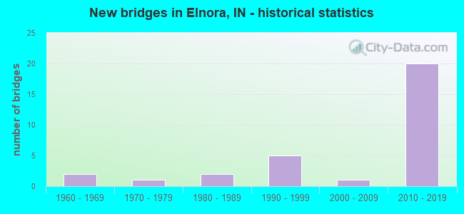
- New bridges - historical statistics
- 21960-1969
- 11970-1979
- 21980-1989
- 51990-1999
- 12000-2009
- 202010-2019


- Bridge Condition - Deck
- 73.9%Good
- 26.1%Satisfactory

- Bridge Condition - Superstructure
- 17.4%Very good
- 52.2%Good
- 21.7%Satisfactory
- 8.7%Fair

- Bridge Condition - Substructure
- 17.4%Very good
- 78.3%Good
- 4.3%Satisfactory

- Bridge Condition - Channel
- 35.0%Very good
- 35.0%Good
- 25.0%Satisfactory
- 5.0%Fair

- Bridge Condition - Culverts
- 50.0%Very good
- 50.0%Good
Find on map >> Show street view
Structure Number: 2068, Location: 01.69 N SR 58 (Lat: 38.889189, Lng: -87.069650), Route carried "on" structure: State highway 57, Year Built: 2004, Status: Open, Structure Length: 0.82m (2.69ft), Average Daily Traffic: 2,680 (year 2004), Truck Traffic: 10%, Average Future Daily Traffic: 3,711 (year 2032), Design Load: HS 20, Features Intersected: VERTREES DITCH
Minimum Vertical Clearance: 30+ m (98+ ft), Kilometerpoint: 44.370, Lanes on structure: 2, Owner: State Highway Agency, Approaching Roadway Width: 12.5m (41.0ft), Skew: 4 degrees, Material/Design: Concrete, Design/Construction: Culvert, Number Of Spans In Main Unit: 1, Length of Maximum Span: 7.8m (25.6ft)
Condition: Channel: Good, Culverts: Good, Operating Rating: 54.5 metric tons, Method Used To Determine Operating Rating: Field evaluation and documented engineering judgment, Inventory Rating: 32.7 metric tons, Method Used To Determine Inventory Rating: Field evaluation and documented engineering judgment, Structural Evaluation: Better than present minimum criteria, Waterway Adequacy: Equal to present desirable criteria, Approach Roadway Alignment: Equal to present desirable criteria, Designated Inspection Frequency: Every 24 months, Inspection Date: August 2021
Find on map >> Show street view
Structure Number: 2069, Location: 02.25 N SR 58 (Lat: 38.895931, Lng: -87.064139), Route carried "on" structure: State highway 57, Year Built: 1986, Status: Open, Structure Length: 3.44m (11.29ft), Average Daily Traffic: 1,336 (year 2018), Truck Traffic: 30%, Average Future Daily Traffic: 1,600 (year 2038), Design Load: HS 20, Features Intersected: WEAVER DITCH
Minimum Vertical Clearance: 30+ m (98+ ft), Kilometerpoint: 45.271, Lanes on structure: 2, Owner: State Highway Agency, Approaching Roadway Width: 8.5m (27.9ft), Skew: 3 degrees, Material/Design: Concrete continuous, Design/Construction: Slab, Number Of Spans In Main Unit: 3, Length of Maximum Span: 13.4m (44.0ft), Curb-To-Curb Width: 13.4m (44.0ft), Out-to-Out Width: 14.3m (46.9ft)
Condition: Deck: Good, Superstructure: Good, Substructure: Good, Channel: Very good, Operating Rating: 50.9 metric tons, Method Used To Determine Operating Rating: Load and Resistance Factor Rating (LRFR) rating reported by rating factor(RF) method using HL-93 loadings, Inventory Rating: 33.4 metric tons, Method Used To Determine Inventory Rating: Load and Resistance Factor Rating (LRFR) rating reported by rating factor(RF) method using HL-93 loadings, Structural Evaluation: Better than present minimum criteria, Deck Geometry: Equal to present desirable criteria, Waterway Adequacy: Superior to present desirable criteria, Approach Roadway Alignment: Equal to present desirable criteria, Designated Inspection Frequency: Every 24 months, Inspection Date: August 2021, Deck Structure Type: Concrete Cast-file-Place, Wearing Surface/Protective System: Wearing Surface: Epoxy Overlay, Deck Protection: Epoxy Coated Reinforcing
Find on map >> Show street view
Structure Number: 2086, Location: 01.73 W SR 57 (Lat: 38.876831, Lng: -87.122669), Route carried "on" structure: State highway 58, Year Built: 1996, Status: Open, Structure Length: 31.39m (102.99ft), Average Daily Traffic: 1,641 (year 2004), Truck Traffic: 10%, Average Future Daily Traffic: 2,723 (year 2032), Design Load: HS 20, Features Intersected: WHITE RIVER
Minimum Vertical Clearance: 30+ m (98+ ft), Kilometerpoint: 23.641, Lanes on structure: 2, Owner: State Highway Agency, Approaching Roadway Width: 12.2m (40.0ft), Skew: 3 degrees, Material/Design: Steel continuous, Design/Construction: Stringer/Multi-beam, Number Of Spans In Main Unit: 6, Length of Maximum Span: 56.1m (184.1ft), Curb-To-Curb Width: 11.4m (37.4ft), Out-to-Out Width: 12.3m (40.4ft)
Condition: Deck: Good, Superstructure: Good, Substructure: Good, Channel: Good, Operating Rating: 32.4 metric tons, Method Used To Determine Operating Rating: Load and Resistance Factor Rating (LRFR) rating reported by rating factor(RF) method using HL-93 loadings, Inventory Rating: 24.9 metric tons, Method Used To Determine Inventory Rating: Load and Resistance Factor Rating (LRFR) rating reported by rating factor(RF) method using HL-93 loadings, Structural Evaluation: Equal to present minimum criteria, Deck Geometry: Equal to present minimum criteria, Waterway Adequacy: Superior to present desirable criteria, Approach Roadway Alignment: Equal to present desirable criteria, Designated Inspection Frequency: Every 24 months, Underwater Inspection Frequency: Every 60 months, Inspection Date: June 2021, Underwater Inspection Date: September 2018, Deck Structure Type: Concrete Cast-file-Place, Wearing Surface/Protective System: Wearing Surface: Epoxy Overlay, Deck Protection: Epoxy Coated Reinforcing
Find on map >> Show street view
Structure Number: 79678, Location: 00.36 E JCT SR 358 (Lat: 38.846139, Lng: -87.081061), Route carried "on" structure: State highway 58, Year Built: 2014, Status: Open, Structure Length: 0.66m (2.17ft), Average Daily Traffic: 2,550 (year 2014), Truck Traffic: 11%, Average Future Daily Traffic: 2,730 (year 2034), Design Load: HL 93, Features Intersected: FINDLEY LATERAL
Minimum Vertical Clearance: 30+ m (98+ ft), Kilometerpoint: 0.579, Lanes on structure: 2, Owner: State Highway Agency, Approaching Roadway Width: 7.8m (25.6ft), Skew: 3 degrees, Material/Design: Concrete, Design/Construction: Culvert, Number Of Spans In Main Unit: 1, Length of Maximum Span: 6.6m (21.7ft), Curb-To-Curb Width: 10.6m (34.8ft), Out-to-Out Width: 10.6m (34.8ft)
Condition: Channel: Very good, Culverts: Very good, Operating Rating: 40.5 metric tons, Method Used To Determine Operating Rating: Load and Resistance Factor Rating (LRFR) rating reported by rating factor(RF) method using HL-93 loadings, Inventory Rating: 31.4 metric tons, Method Used To Determine Inventory Rating: Load and Resistance Factor Rating (LRFR) rating reported by rating factor(RF) method using HL-93 loadings, Structural Evaluation: Better than present minimum criteria, Deck Geometry: Somewhat better than minimum adequacy, Waterway Adequacy: Equal to present desirable criteria, Approach Roadway Alignment: Equal to present desirable criteria, Designated Inspection Frequency: Every 24 months, Inspection Date: Febuary 2021
Find on map >> Show street view
Structure Number: 80298, Location: 02.34 S SR 58 (Lat: 38.811650, Lng: -87.069989), Route carried "on" structure: Interstate 69, Year Built: 2011, Status: Open, Structure Length: 5.14m (16.86ft), Average Daily Traffic: 7,550 (year 2010), Truck Traffic: 23%, Average Future Daily Traffic: 10,723 (year 2030), Design Load: HL 93, Features Intersected: EPSOM LATERAL
Minimum Vertical Clearance: 30+ m (98+ ft), Kilometerpoint: 118.448, Lanes on structure: 2, Base Highway Network: Yes (, Subroute: 1), Owner: State Highway Agency, Approaching Roadway Width: 11.6m (38.1ft), Material/Design: Prestressed concrete continuous, Design/Construction: Tee Beam, Number Of Spans In Main Unit: 2, Length of Maximum Span: 24.8m (81.4ft), Curb-To-Curb Width: 12.3m (40.4ft), Out-to-Out Width: 13.2m (43.3ft)
Condition: Deck: Good, Superstructure: Good, Substructure: Good, Channel: Good, Operating Rating: 52.2 metric tons, Method Used To Determine Operating Rating: Load and Resistance Factor Rating (LRFR) rating reported by rating factor(RF) method using HL-93 loadings, Inventory Rating: 32.1 metric tons, Method Used To Determine Inventory Rating: Load and Resistance Factor Rating (LRFR) rating reported by rating factor(RF) method using HL-93 loadings, Structural Evaluation: Better than present minimum criteria, Deck Geometry: Better than present minimum criteria, Waterway Adequacy: Superior to present desirable criteria, Approach Roadway Alignment: Equal to present desirable criteria, Designated Inspection Frequency: Every 24 months, Inspection Date: January 2021, Deck Structure Type: Concrete Cast-file-Place, Wearing Surface/Protective System: Wearing Surface: Monolithic Concrete, Deck Protection: Epoxy Coated Reinforcing
Find on map >> Show street view
Structure Number: 803, Location: 02.34 S SR 58 (Lat: 38.811650, Lng: -87.070300), Route carried "on" structure: Interstate 69, Year Built: 2011, Status: Open, Structure Length: 5.14m (16.86ft), Average Daily Traffic: 7,550 (year 2010), Truck Traffic: 23%, Average Future Daily Traffic: 10,723 (year 2030), Design Load: HL 93, Features Intersected: EPSOM LATERAL
Minimum Vertical Clearance: 30+ m (98+ ft), Kilometerpoint: 118.448, Lanes on structure: 2, Base Highway Network: Yes (, Subroute: 1), Owner: State Highway Agency, Approaching Roadway Width: 11.6m (38.1ft), Material/Design: Prestressed concrete continuous, Design/Construction: Tee Beam, Number Of Spans In Main Unit: 2, Length of Maximum Span: 24.8m (81.4ft), Curb-To-Curb Width: 12.3m (40.4ft), Out-to-Out Width: 13.2m (43.3ft)
Condition: Deck: Good, Superstructure: Good, Substructure: Good, Channel: Very good, Operating Rating: 52.2 metric tons, Method Used To Determine Operating Rating: Load and Resistance Factor Rating (LRFR) rating reported by rating factor(RF) method using HL-93 loadings, Inventory Rating: 32.1 metric tons, Method Used To Determine Inventory Rating: Load and Resistance Factor Rating (LRFR) rating reported by rating factor(RF) method using HL-93 loadings, Structural Evaluation: Better than present minimum criteria, Deck Geometry: Better than present minimum criteria, Waterway Adequacy: Superior to present desirable criteria, Approach Roadway Alignment: Equal to present desirable criteria, Designated Inspection Frequency: Every 24 months, Inspection Date: January 2021, Deck Structure Type: Concrete Cast-file-Place, Wearing Surface/Protective System: Wearing Surface: Monolithic Concrete, Deck Protection: Epoxy Coated Reinforcing
Find on map >> Show street view
Structure Number: 80302, Location: 01.36 S SR 58 (Lat: 38.826011, Lng: -87.070100), Route carried "on" structure: Interstate 69, Year Built: 2011, Status: Open, Structure Length: 6.04m (19.82ft), Average Daily Traffic: 7,550 (year 2010), Truck Traffic: 23%, Average Future Daily Traffic: 10,723 (year 2030), Design Load: HL 93, Features Intersected: SMOTHERS CREEK
Minimum Vertical Clearance: 30+ m (98+ ft), Kilometerpoint: 120.025, Lanes on structure: 2, Base Highway Network: Yes (, Subroute: 1), Owner: State Highway Agency, Approaching Roadway Width: 11.6m (38.1ft), Skew: 4 degrees, Material/Design: Prestressed concrete continuous, Design/Construction: Tee Beam, Number Of Spans In Main Unit: 2, Length of Maximum Span: 30.9m (101.4ft), Curb-To-Curb Width: 12.3m (40.4ft), Out-to-Out Width: 13.2m (43.3ft)
Condition: Deck: Good, Superstructure: Very good, Substructure: Good, Channel: Very good, Operating Rating: 54.8 metric tons, Method Used To Determine Operating Rating: Load and Resistance Factor Rating (LRFR) rating reported by rating factor(RF) method using HL-93 loadings, Inventory Rating: 34.0 metric tons, Method Used To Determine Inventory Rating: Load and Resistance Factor Rating (LRFR) rating reported by rating factor(RF) method using HL-93 loadings, Structural Evaluation: Better than present minimum criteria, Deck Geometry: Better than present minimum criteria, Waterway Adequacy: Superior to present desirable criteria, Approach Roadway Alignment: Equal to present desirable criteria, Designated Inspection Frequency: Every 24 months, Inspection Date: January 2021, Deck Structure Type: Concrete Cast-file-Place, Wearing Surface/Protective System: Wearing Surface: Monolithic Concrete, Deck Protection: Epoxy Coated Reinforcing
Find on map >> Show street view
Structure Number: 80304, Location: 01.36 S SR 58 (Lat: 38.825781, Lng: -87.070389), Route carried "on" structure: Interstate 69, Year Built: 2011, Status: Open, Structure Length: 6.04m (19.82ft), Average Daily Traffic: 7,550 (year 2010), Truck Traffic: 23%, Average Future Daily Traffic: 10,723 (year 2030), Design Load: HL 93, Features Intersected: SMOTHERS CREEK
Minimum Vertical Clearance: 30+ m (98+ ft), Kilometerpoint: 120.025, Lanes on structure: 2, Base Highway Network: Yes (, Subroute: 1), Owner: State Highway Agency, Approaching Roadway Width: 11.6m (38.1ft), Skew: 4 degrees, Material/Design: Prestressed concrete continuous, Design/Construction: Tee Beam, Number Of Spans In Main Unit: 2, Length of Maximum Span: 30.9m (101.4ft), Curb-To-Curb Width: 12.3m (40.4ft), Out-to-Out Width: 13.2m (43.3ft)
Condition: Deck: Good, Superstructure: Very good, Substructure: Good, Channel: Very good, Operating Rating: 54.8 metric tons, Method Used To Determine Operating Rating: Load and Resistance Factor Rating (LRFR) rating reported by rating factor(RF) method using HL-93 loadings, Inventory Rating: 34.0 metric tons, Method Used To Determine Inventory Rating: Load and Resistance Factor Rating (LRFR) rating reported by rating factor(RF) method using HL-93 loadings, Structural Evaluation: Better than present minimum criteria, Deck Geometry: Better than present minimum criteria, Waterway Adequacy: Superior to present desirable criteria, Approach Roadway Alignment: Equal to present desirable criteria, Designated Inspection Frequency: Every 24 months, Inspection Date: January 2021, Deck Structure Type: Concrete Cast-file-Place, Wearing Surface/Protective System: Wearing Surface: Monolithic Concrete, Deck Protection: Epoxy Coated Reinforcing
Find on map >> Show street view
Structure Number: 80316, Location: 01.60 N SR 58 (Lat: 38.868269, Lng: -87.070350), Route carried "on" structure: Interstate 69, Year Built: 2011, Status: Open, Structure Length: 3.49m (11.45ft), Average Daily Traffic: 6,837 (year 2010), Truck Traffic: 25%, Average Future Daily Traffic: 9,605 (year 2030), Design Load: HL 93, Features Intersected: INDIANA RR CO
Minimum Vertical Clearance: 30+ m (98+ ft), Kilometerpoint: 124.740, Lanes on structure: 2, Base Highway Network: Yes (, Subroute: 1), Owner: State Highway Agency, Approaching Roadway Width: 11.6m (38.1ft), Skew: 4 degrees, Material/Design: Prestressed concrete, Design/Construction: Tee Beam, Number Of Spans In Main Unit: 1, Length of Maximum Span: 32.3m (106.0ft), Curb-To-Curb Width: 12.3m (40.4ft), Out-to-Out Width: 13.2m (43.3ft)
Condition: Deck: Good, Superstructure: Very good, Substructure: Very good, Operating Rating: 64.2 metric tons, Method Used To Determine Operating Rating: Load and Resistance Factor Rating (LRFR) rating reported by rating factor(RF) method using HL-93 loadings, Inventory Rating: 38.6 metric tons, Method Used To Determine Inventory Rating: Load and Resistance Factor Rating (LRFR) rating reported by rating factor(RF) method using HL-93 loadings, Structural Evaluation: Equal to present desirable criteria, Deck Geometry: Better than present minimum criteria, Underclear: Superior to present desirable criteria, Approach Roadway Alignment: Equal to present desirable criteria, Designated Inspection Frequency: Every 24 months, Inspection Date: Febuary 2021, Deck Structure Type: Concrete Cast-file-Place, Wearing Surface/Protective System: Wearing Surface: Monolithic Concrete, Deck Protection: Epoxy Coated Reinforcing
Find on map >> Show street view
Structure Number: 80318, Location: 01.60 N SR 58 (Lat: 38.868550, Lng: -87.070681), Route carried "on" structure: Interstate 69, Year Built: 2011, Status: Open, Structure Length: 3.49m (11.45ft), Average Daily Traffic: 6,837 (year 2010), Truck Traffic: 25%, Average Future Daily Traffic: 9,605 (year 2030), Design Load: HL 93, Features Intersected: INDIANA RR CO
Minimum Vertical Clearance: 30+ m (98+ ft), Kilometerpoint: 124.740, Lanes on structure: 2, Base Highway Network: Yes (, Subroute: 1), Owner: State Highway Agency, Approaching Roadway Width: 11.6m (38.1ft), Skew: 4 degrees, Material/Design: Prestressed concrete, Design/Construction: Tee Beam, Number Of Spans In Main Unit: 1, Length of Maximum Span: 32.3m (106.0ft), Curb-To-Curb Width: 12.3m (40.4ft), Out-to-Out Width: 13.2m (43.3ft)
Condition: Deck: Good, Superstructure: Good, Substructure: Good, Operating Rating: 64.2 metric tons, Method Used To Determine Operating Rating: Load and Resistance Factor Rating (LRFR) rating reported by rating factor(RF) method using HL-93 loadings, Inventory Rating: 38.6 metric tons, Method Used To Determine Inventory Rating: Load and Resistance Factor Rating (LRFR) rating reported by rating factor(RF) method using HL-93 loadings, Structural Evaluation: Better than present minimum criteria, Deck Geometry: Better than present minimum criteria, Underclear: Superior to present desirable criteria, Approach Roadway Alignment: Equal to present desirable criteria, Designated Inspection Frequency: Every 24 months, Inspection Date: Febuary 2021, Deck Structure Type: Concrete Cast-file-Place, Wearing Surface/Protective System: Wearing Surface: Monolithic Concrete, Deck Protection: Epoxy Coated Reinforcing
Find on map >> Show street view
Structure Number: 8032, Location: 02.04 N SR 58 (Lat: 38.874750, Lng: -87.070581), Route carried "on" structure: County highway , Year Built: 2012, Status: Open, Structure Length: 7.01m (23.00ft), Average Daily Traffic: 287 (year 2010), Truck Traffic: 8%, Average Future Daily Traffic: 310 (year 2030), Design Load: HL 93, Features Intersected: I-69 NB/SB, Facility Carried by Structure: CR 1500N
Minimum Vertical Clearance: 30+ m (98+ ft), Kilometerpoint: 125.448, Lanes on structure: 2, Lanes under structure: 4, Owner: State Highway Agency, Approaching Roadway Width: 8.3m (27.2ft), Material/Design: Prestressed concrete continuous, Design/Construction: Tee Beam, Number Of Spans In Main Unit: 2, Length of Maximum Span: 34.7m (113.8ft), Curb-To-Curb Width: 8.3m (27.2ft), Out-to-Out Width: 9.2m (30.2ft)
Condition: Deck: Good, Superstructure: Good, Substructure: Good, Operating Rating: 55.1 metric tons, Method Used To Determine Operating Rating: Load and Resistance Factor Rating (LRFR) rating reported by rating factor(RF) method using HL-93 loadings, Inventory Rating: 34.3 metric tons, Method Used To Determine Inventory Rating: Load and Resistance Factor Rating (LRFR) rating reported by rating factor(RF) method using HL-93 loadings, Structural Evaluation: Better than present minimum criteria, Deck Geometry: Somewhat better than minimum adequacy, Underclear: Equal to present minimum criteria, Approach Roadway Alignment: Equal to present desirable criteria, Designated Inspection Frequency: Every 24 months, Inspection Date: Febuary 2021, Deck Structure Type: Concrete Cast-file-Place, Wearing Surface/Protective System: Wearing Surface: Monolithic Concrete, Deck Protection: Epoxy Coated Reinforcing
Find on map >> Show street view
Structure Number: 80322, Location: 03.09 N SR 58 (Lat: 38.888531, Lng: -87.062581), Route carried "on" structure: Interstate 69, Year Built: 2011, Status: Open, Structure Length: 3.54m (11.61ft), Average Daily Traffic: 6,837 (year 2010), Truck Traffic: 25%, Average Future Daily Traffic: 9,605 (year 2030), Design Load: HL 93, Features Intersected: VERTREES DITCH
Minimum Vertical Clearance: 30+ m (98+ ft), Kilometerpoint: 127.203, Lanes on structure: 2, Base Highway Network: Yes (, Subroute: 1), Owner: State Highway Agency, Approaching Roadway Width: 12.3m (40.4ft), Material/Design: Prestressed concrete continuous, Design/Construction: Tee Beam, Number Of Spans In Main Unit: 1, Length of Maximum Span: 34.7m (113.8ft), Curb-To-Curb Width: 12.3m (40.4ft), Out-to-Out Width: 13.2m (43.3ft)
Condition: Deck: Good, Superstructure: Good, Substructure: Very good, Channel: Very good, Operating Rating: 53.8 metric tons, Method Used To Determine Operating Rating: Load and Resistance Factor Rating (LRFR) rating reported by rating factor(RF) method using HL-93 loadings, Inventory Rating: 32.4 metric tons, Method Used To Determine Inventory Rating: Load and Resistance Factor Rating (LRFR) rating reported by rating factor(RF) method using HL-93 loadings, Structural Evaluation: Better than present minimum criteria, Deck Geometry: Better than present minimum criteria, Waterway Adequacy: Superior to present desirable criteria, Approach Roadway Alignment: Equal to present desirable criteria, Designated Inspection Frequency: Every 24 months, Inspection Date: Febuary 2021, Deck Structure Type: Concrete Cast-file-Place, Wearing Surface/Protective System: Wearing Surface: Monolithic Concrete, Deck Protection: Epoxy Coated Reinforcing
Find on map >> Show street view
Structure Number: 80324, Location: 03.09 N SR 58 (Lat: 38.888681, Lng: -87.062831), Route carried "on" structure: Interstate 69, Year Built: 2011, Status: Open, Structure Length: 3.54m (11.61ft), Average Daily Traffic: 6,837 (year 2010), Truck Traffic: 25%, Average Future Daily Traffic: 9,605 (year 2030), Design Load: HL 93, Features Intersected: VERTREES DITCH
Minimum Vertical Clearance: 30+ m (98+ ft), Kilometerpoint: 127.203, Lanes on structure: 2, Base Highway Network: Yes (, Subroute: 1), Owner: State Highway Agency, Approaching Roadway Width: 12.3m (40.4ft), Material/Design: Prestressed concrete continuous, Design/Construction: Tee Beam, Number Of Spans In Main Unit: 1, Length of Maximum Span: 34.7m (113.8ft), Curb-To-Curb Width: 12.3m (40.4ft), Out-to-Out Width: 13.2m (43.3ft)
Condition: Deck: Good, Superstructure: Good, Substructure: Good, Channel: Good, Operating Rating: 53.8 metric tons, Method Used To Determine Operating Rating: Load and Resistance Factor Rating (LRFR) rating reported by rating factor(RF) method using HL-93 loadings, Inventory Rating: 32.4 metric tons, Method Used To Determine Inventory Rating: Load and Resistance Factor Rating (LRFR) rating reported by rating factor(RF) method using HL-93 loadings, Structural Evaluation: Better than present minimum criteria, Deck Geometry: Better than present minimum criteria, Waterway Adequacy: Superior to present desirable criteria, Approach Roadway Alignment: Equal to present desirable criteria, Designated Inspection Frequency: Every 24 months, Inspection Date: Febuary 2021, Deck Structure Type: Concrete Cast-file-Place, Wearing Surface/Protective System: Wearing Surface: Monolithic Concrete, Deck Protection: Epoxy Coated Reinforcing
Find on map >> Show street view
Structure Number: 80326, Location: 03.55 N SR 58 (Lat: 38.893311, Lng: -87.056561), Route carried "on" structure: Interstate 69, Year Built: 2012, Status: Open, Structure Length: 2.96m (9.71ft), Average Daily Traffic: 6,837 (year 2010), Truck Traffic: 25%, Average Future Daily Traffic: 9,605 (year 2030), Design Load: HL 93, Features Intersected: WEAVER DITCH
Minimum Vertical Clearance: 30+ m (98+ ft), Kilometerpoint: 127.943, Lanes on structure: 2, Base Highway Network: Yes (, Subroute: 1), Owner: State Highway Agency, Approaching Roadway Width: 12.3m (40.4ft), Skew: 1 degrees, Material/Design: Prestressed concrete continuous, Design/Construction: Tee Beam, Number Of Spans In Main Unit: 1, Length of Maximum Span: 29.0m (95.1ft), Curb-To-Curb Width: 12.3m (40.4ft), Out-to-Out Width: 13.2m (43.3ft)
Condition: Deck: Good, Superstructure: Good, Substructure: Good, Channel: Very good, Operating Rating: 54.8 metric tons, Method Used To Determine Operating Rating: Load and Resistance Factor Rating (LRFR) rating reported by rating factor(RF) method using HL-93 loadings, Inventory Rating: 33.4 metric tons, Method Used To Determine Inventory Rating: Load and Resistance Factor Rating (LRFR) rating reported by rating factor(RF) method using HL-93 loadings, Structural Evaluation: Better than present minimum criteria, Deck Geometry: Better than present minimum criteria, Waterway Adequacy: Superior to present desirable criteria, Approach Roadway Alignment: Equal to present desirable criteria, Designated Inspection Frequency: Every 24 months, Inspection Date: Febuary 2021, Deck Structure Type: Concrete Cast-file-Place, Wearing Surface/Protective System: Wearing Surface: Monolithic Concrete, Deck Protection: Epoxy Coated Reinforcing
Find on map >> Show street view
Structure Number: 80328, Location: 03.55 N SR 58 (Lat: 38.893450, Lng: -87.056831), Route carried "on" structure: Interstate 69, Year Built: 2012, Status: Open, Structure Length: 2.96m (9.71ft), Average Daily Traffic: 6,837 (year 2010), Truck Traffic: 25%, Average Future Daily Traffic: 9,605 (year 2030), Design Load: HL 93, Features Intersected: WEAVER DITCH
Minimum Vertical Clearance: 30+ m (98+ ft), Kilometerpoint: 127.943, Lanes on structure: 2, Base Highway Network: Yes (, Subroute: 1), Owner: State Highway Agency, Approaching Roadway Width: 12.3m (40.4ft), Skew: 1 degrees, Material/Design: Prestressed concrete continuous, Design/Construction: Tee Beam, Number Of Spans In Main Unit: 1, Length of Maximum Span: 29.0m (95.1ft), Curb-To-Curb Width: 12.3m (40.4ft), Out-to-Out Width: 13.2m (43.3ft)
Condition: Deck: Good, Superstructure: Good, Substructure: Good, Channel: Good, Operating Rating: 54.8 metric tons, Method Used To Determine Operating Rating: Load and Resistance Factor Rating (LRFR) rating reported by rating factor(RF) method using HL-93 loadings, Inventory Rating: 33.4 metric tons, Method Used To Determine Inventory Rating: Load and Resistance Factor Rating (LRFR) rating reported by rating factor(RF) method using HL-93 loadings, Structural Evaluation: Better than present minimum criteria, Deck Geometry: Better than present minimum criteria, Waterway Adequacy: Superior to present desirable criteria, Approach Roadway Alignment: Equal to present desirable criteria, Designated Inspection Frequency: Every 24 months, Inspection Date: Febuary 2021, Deck Structure Type: Concrete Cast-file-Place, Wearing Surface/Protective System: Wearing Surface: Monolithic Concrete, Deck Protection: Epoxy Coated Reinforcing
Find on map >> Show street view
Structure Number: 80348, Location: 01.40 S SR 58 (Lat: 38.831111, Lng: -87.070269), Route carried "on" structure: County highway 1200, Year Built: 2012, Status: Open, Structure Length: 6.88m (22.57ft), Average Daily Traffic: 100 (year 2010), Truck Traffic: 2%, Average Future Daily Traffic: 150 (year 2030), Design Load: HL 93, Features Intersected: I-69 NB/SB
Minimum Vertical Clearance: 30+ m (98+ ft), Kilometerpoint: 119.912, Lanes on structure: 2, Lanes under structure: 4, Owner: State Highway Agency, Approaching Roadway Width: 8.4m (27.6ft), Material/Design: Prestressed concrete continuous, Design/Construction: Tee Beam, Number Of Spans In Main Unit: 2, Length of Maximum Span: 34.1m (111.9ft), Curb-To-Curb Width: 8.4m (27.6ft), Out-to-Out Width: 9.3m (30.5ft)
Condition: Deck: Good, Superstructure: Good, Substructure: Good, Operating Rating: 48.0 metric tons, Method Used To Determine Operating Rating: Load and Resistance Factor Rating (LRFR) rating reported by rating factor(RF) method using HL-93 loadings, Inventory Rating: 36.9 metric tons, Method Used To Determine Inventory Rating: Load and Resistance Factor Rating (LRFR) rating reported by rating factor(RF) method using HL-93 loadings, Structural Evaluation: Better than present minimum criteria, Deck Geometry: Equal to present minimum criteria, Underclear: Equal to present minimum criteria, Approach Roadway Alignment: Equal to present desirable criteria, Designated Inspection Frequency: Every 24 months, Inspection Date: January 2021, Deck Structure Type: Concrete Cast-file-Place, Wearing Surface/Protective System: Wearing Surface: Monolithic Concrete, Deck Protection: Epoxy Coated Reinforcing
Find on map >> Show street view
Structure Number: 80376, Location: 00.94 W SR 258 (Lat: 38.845700, Lng: -87.070361), Route carried "on" structure: State highway 58, Year Built: 2011, Status: Open, Structure Length: 5.65m (18.54ft), Average Daily Traffic: 4,900 (year 2010), Truck Traffic: 14%, Average Future Daily Traffic: 5,965 (year 2030), Design Load: HL 93, Features Intersected: I-69 SB/NB
Minimum Vertical Clearance: 30+ m (98+ ft), Kilometerpoint: 7.725, Lanes on structure: 3, Lanes under structure: 4, Owner: State Highway Agency, Approaching Roadway Width: 12.2m (40.0ft), Material/Design: Prestressed concrete continuous, Design/Construction: Tee Beam, Number Of Spans In Main Unit: 2, Length of Maximum Span: 27.4m (89.9ft), Curb-To-Curb Width: 16.9m (55.4ft), Out-to-Out Width: 17.8m (58.4ft)
Condition: Deck: Good, Superstructure: Very good, Substructure: Very good, Operating Rating: 46.7 metric tons, Method Used To Determine Operating Rating: Load and Resistance Factor Rating (LRFR) rating reported by rating factor(RF) method using HL-93 loadings, Inventory Rating: 28.2 metric tons, Method Used To Determine Inventory Rating: Load and Resistance Factor Rating (LRFR) rating reported by rating factor(RF) method using HL-93 loadings, Structural Evaluation: Better than present minimum criteria, Deck Geometry: Superior to present desirable criteria, Underclear: Better than present minimum criteria, Approach Roadway Alignment: Equal to present desirable criteria, Designated Inspection Frequency: Every 24 months, Inspection Date: January 2021, Deck Structure Type: Concrete Cast-file-Place, Wearing Surface/Protective System: Wearing Surface: Monolithic Concrete, Deck Protection: Epoxy Coated Reinforcing
Find on map >> Show street view
Structure Number: 1400004, Location: 00.56 N of CR 1625 N (Lat: 38.901300, Lng: -87.073169), Route carried "on" structure: Alternate County highway 193, Year Built: 1978, Year Reconstructed: 2003, Status: Open, Structure Length: 1.13m (3.71ft), Average Daily Traffic: 135 (year 2013), Truck Traffic: 10%, Average Future Daily Traffic: 177 (year 2033), Design Load: HS 20, Features Intersected: WEAVER DITCH, Facility Carried by Structure: CR 500E
Minimum Vertical Clearance: 30+ m (98+ ft), Kilometerpoint: 0.000, Lanes on structure: 2, Owner: County Highway Agency, Approaching Roadway Width: 6.1m (20.0ft), Material/Design: Steel, Design/Construction: Stringer/Multi-beam, Number Of Spans In Main Unit: 1, Length of Maximum Span: 9.8m (32.2ft), Curb-To-Curb Width: 7.3m (24.0ft), Out-to-Out Width: 7.3m (24.0ft)
Condition: Deck: Good, Superstructure: Fair, Substructure: Good, Channel: Satisfactory, Operating Rating: 94.3 metric tons, Method Used To Determine Operating Rating: Load Factor (LF), Inventory Rating: 56.3 metric tons, Method Used To Determine Inventory Rating: Load Factor (LF), Structural Evaluation: Somewhat better than minimum adequacy, Deck Geometry: Somewhat better than minimum adequacy, Waterway Adequacy: Meets minimum limits, Approach Roadway Alignment: Equal to present desirable criteria, Designated Inspection Frequency: Every 24 months, Inspection Date: June 2021, Deck Structure Type: Open Grating
Find on map >> Show street view
Structure Number: 1400005, Location: 00.19 S of CR 1600 N (Lat: 38.886739, Lng: -87.073489), Route carried "on" structure: Alternate County highway 193, Year Built: 1996, Status: Posted for load, Structure Length: 1.21m (3.97ft), Average Daily Traffic: 87 (year 2013), Truck Traffic: 10%, Average Future Daily Traffic: 114 (year 2033), Design Load: HS 20, Features Intersected: VERTREES DITCH, Facility Carried by Structure: CR 500E
Minimum Vertical Clearance: 30+ m (98+ ft), Kilometerpoint: 0.000, Lanes on structure: 2, Owner: County Highway Agency, Approaching Roadway Width: 7.3m (24.0ft), Skew: 3 degrees, Material/Design: Concrete, Design/Construction: Channel Beam, Number Of Spans In Main Unit: 1, Length of Maximum Span: 11.0m (36.1ft), Curb-To-Curb Width: 7.9m (25.9ft), Out-to-Out Width: 8.1m (26.6ft)
Condition: Deck: Satisfactory, Superstructure: Satisfactory, Substructure: Good, Channel: Good, Operating Rating: 24.9 metric tons, Method Used To Determine Operating Rating: Load and Resistance Factor Rating (LRFR) rating reported by rating factor(RF) method using HL-93 loadings, Inventory Rating: 19.1 metric tons, Method Used To Determine Inventory Rating: Load and Resistance Factor Rating (LRFR) rating reported by rating factor(RF) method using HL-93 loadings, Structural Evaluation: Somewhat better than minimum adequacy, Deck Geometry: Equal to present minimum criteria, Waterway Adequacy: Better than present minimum criteria, Approach Roadway Alignment: High priority of corrective action, Bridge Posting: Required (Relationship of Operating Rating to Maximum Legal Load: 20.0 - 29.9% below), Designated Inspection Frequency: Every 24 months, Inspection Date: June 2021, Deck Structure Type: Concrete Precast Panels, Wearing Surface/Protective System: Wearing Surface: Bituminous
Find on map >> Show street view
Structure Number: 1400006, Location: 00.36 E of CR 600 E (Lat: 38.888419, Lng: -87.048089), Route carried "on" structure: County highway 76, Year Built: 1997, Status: Posted for load, Structure Length: 1.23m (4.04ft), Average Daily Traffic: 135 (year 2013), Truck Traffic: 10%, Average Future Daily Traffic: 177 (year 2033), Design Load: HS 20, Features Intersected: WEAVER DITCH, Facility Carried by Structure: CR 1600N
Minimum Vertical Clearance: 30+ m (98+ ft), Kilometerpoint: 0.000, Lanes on structure: 2, Owner: County Highway Agency, Approaching Roadway Width: 7.0m (23.0ft), Skew: 3 degrees, Material/Design: Concrete, Design/Construction: Channel Beam, Number Of Spans In Main Unit: 1, Length of Maximum Span: 9.4m (30.8ft), Curb-To-Curb Width: 7.9m (25.9ft), Out-to-Out Width: 8.1m (26.6ft)
Condition: Deck: Satisfactory, Superstructure: Satisfactory, Substructure: Good, Channel: Fair, Operating Rating: 27.5 metric tons, Method Used To Determine Operating Rating: Load and Resistance Factor Rating (LRFR) rating reported by rating factor(RF) method using HL-93 loadings, Inventory Rating: 21.4 metric tons, Method Used To Determine Inventory Rating: Load and Resistance Factor Rating (LRFR) rating reported by rating factor(RF) method using HL-93 loadings, Structural Evaluation: Equal to present minimum criteria, Deck Geometry: Somewhat better than minimum adequacy, Waterway Adequacy: Equal to present minimum criteria, Approach Roadway Alignment: Equal to present desirable criteria, Bridge Posting: Required (Relationship of Operating Rating to Maximum Legal Load: 10.0 - 19.9% below), Designated Inspection Frequency: Every 24 months, Inspection Date: June 2021, Deck Structure Type: Concrete Precast Panels, Wearing Surface/Protective System: Wearing Surface: Bituminous
Find on map >> Show street view
Structure Number: 1400014, Location: 00.21 E of CR 475 E (Lat: 38.816700, Lng: -87.074900), Route carried "on" structure: County highway 62, Year Built: 1996, Status: Posted for load, Structure Length: 2.47m (8.10ft), Average Daily Traffic: 97 (year 2013), Truck Traffic: 10%, Average Future Daily Traffic: 127 (year 2033), Design Load: HS 20, Features Intersected: SMOTHERS CREEK, Facility Carried by Structure: CR 1100N
Minimum Vertical Clearance: 30+ m (98+ ft), Kilometerpoint: 0.000, Lanes on structure: 2, Owner: County Highway Agency, Approaching Roadway Width: 6.1m (20.0ft), Material/Design: Concrete, Design/Construction: Channel Beam, Number Of Spans In Main Unit: 3, Length of Maximum Span: 8.2m (26.9ft), Curb-To-Curb Width: 7.9m (25.9ft), Out-to-Out Width: 8.1m (26.6ft)
Condition: Deck: Satisfactory, Superstructure: Satisfactory, Substructure: Satisfactory, Channel: Satisfactory, Operating Rating: 21.4 metric tons, Method Used To Determine Operating Rating: Load and Resistance Factor Rating (LRFR) rating reported by rating factor(RF) method using HL-93 loadings, Inventory Rating: 16.5 metric tons, Method Used To Determine Inventory Rating: Load and Resistance Factor Rating (LRFR) rating reported by rating factor(RF) method using HL-93 loadings, Structural Evaluation: Somewhat better than minimum adequacy, Deck Geometry: Equal to present minimum criteria, Waterway Adequacy: Better than present minimum criteria, Approach Roadway Alignment: Equal to present desirable criteria, Bridge Posting: Required (Relationship of Operating Rating to Maximum Legal Load: 20.0 - 29.9% below), Designated Inspection Frequency: Every 24 months, Inspection Date: June 2021, Deck Structure Type: Concrete Precast Panels, Wearing Surface/Protective System: Wearing Surface: Bituminous
Find on map >> Show street view
Structure Number: 1400019, Location: 00.03 S of CR 1200 N (Lat: 38.830161, Lng: -87.060350), Route carried "on" structure: Alternate County highway 175, Year Built: 1981, Status: Open, Structure Length: 3.05m (10.01ft), Average Daily Traffic: 68 (year 2013), Truck Traffic: 10%, Average Future Daily Traffic: 89 (year 2033), Design Load: HS 20, Features Intersected: SMOTHERS CREEK, Facility Carried by Structure: CR 575E
Minimum Vertical Clearance: 30+ m (98+ ft), Kilometerpoint: 0.000, Lanes on structure: 2, Owner: County Highway Agency, Approaching Roadway Width: 6.1m (20.0ft), Material/Design: Concrete continuous, Design/Construction: Slab, Number Of Spans In Main Unit: 3, Length of Maximum Span: 12.2m (40.0ft), Curb-To-Curb Width: 8.6m (28.2ft), Out-to-Out Width: 9.3m (30.5ft)
Condition: Deck: Good, Superstructure: Good, Substructure: Good, Channel: Satisfactory, Operating Rating: 56.1 metric tons, Method Used To Determine Operating Rating: Load and Resistance Factor Rating (LRFR) rating reported by rating factor(RF) method using HL-93 loadings, Inventory Rating: 43.1 metric tons, Method Used To Determine Inventory Rating: Load and Resistance Factor Rating (LRFR) rating reported by rating factor(RF) method using HL-93 loadings, Structural Evaluation: Better than present minimum criteria, Deck Geometry: Better than present minimum criteria, Waterway Adequacy: Somewhat better than minimum adequacy, Approach Roadway Alignment: Equal to present desirable criteria, Designated Inspection Frequency: Every 24 months, Inspection Date: June 2021, Deck Structure Type: Concrete Cast-file-Place, Wearing Surface/Protective System: Wearing Surface: Monolithic Concrete
Find on map >> Show street view
Structure Number: 1400045, Location: 00.80 N of CR 1000 N (Lat: 38.812369, Lng: -87.078869), Route carried "on" structure: County highway 43, Year Built: 1960, Status: Open, Structure Length: 1.59m (5.22ft), Average Daily Traffic: 387 (year 2013), Truck Traffic: 10%, Average Future Daily Traffic: 507 (year 2033), Design Load: H 20, Features Intersected: EPSOM LATERAL, Facility Carried by Structure: CR 475E
Minimum Vertical Clearance: 30+ m (98+ ft), Kilometerpoint: 0.000, Lanes on structure: 2, Owner: County Highway Agency, Approaching Roadway Width: 6.1m (20.0ft), Material/Design: Prestressed concrete, Design/Construction: Box Beam or Girders - Multiple, Number Of Spans In Main Unit: 1, Length of Maximum Span: 15.2m (49.9ft), Curb or Sidewalk Widths: Left: 0.2m (0.7ft), Right: 0.2m (0.7ft), Curb-To-Curb Width: 7.8m (25.6ft), Out-to-Out Width: 8.4m (27.6ft)
Condition: Deck: Satisfactory, Superstructure: Satisfactory, Substructure: Good, Channel: Good, Operating Rating: 45.7 metric tons, Method Used To Determine Operating Rating: Load and Resistance Factor Rating (LRFR) rating reported by rating factor(RF) method using HL-93 loadings, Inventory Rating: 35.3 metric tons, Method Used To Determine Inventory Rating: Load and Resistance Factor Rating (LRFR) rating reported by rating factor(RF) method using HL-93 loadings, Structural Evaluation: Equal to present minimum criteria, Deck Geometry: Somewhat better than minimum adequacy, Waterway Adequacy: Better than present minimum criteria, Approach Roadway Alignment: Equal to present desirable criteria, Designated Inspection Frequency: Every 24 months, Inspection Date: June 2021, Deck Structure Type: Concrete Precast Panels, Wearing Surface/Protective System: Wearing Surface: Bituminous
Find on map >> Show street view
Structure Number: 1400046, Location: 00.93 N of CR 1000 N (Lat: 38.814289, Lng: -87.078869), Route carried "on" structure: County highway 43, Year Built: 1960, Status: Open, Structure Length: 1.71m (5.61ft), Average Daily Traffic: 387 (year 2013), Truck Traffic: 15%, Average Future Daily Traffic: 507 (year 2033), Design Load: H 20, Features Intersected: SMOTHERS CREEK, Facility Carried by Structure: CR 475E
Minimum Vertical Clearance: 30+ m (98+ ft), Kilometerpoint: 0.000, Lanes on structure: 2, Owner: County Highway Agency, Approaching Roadway Width: 6.1m (20.0ft), Skew: 2 degrees, Material/Design: Prestressed concrete, Design/Construction: Box Beam or Girders - Multiple, Number Of Spans In Main Unit: 1, Length of Maximum Span: 16.4m (53.8ft), Curb or Sidewalk Widths: Left: 0.2m (0.7ft), Right: 0.2m (0.7ft), Curb-To-Curb Width: 7.7m (25.3ft), Out-to-Out Width: 8.3m (27.2ft)
Condition: Deck: Satisfactory, Superstructure: Fair, Substructure: Good, Channel: Satisfactory, Operating Rating: 34.0 metric tons, Method Used To Determine Operating Rating: Load and Resistance Factor Rating (LRFR) rating reported by rating factor(RF) method using HL-93 loadings, Inventory Rating: 26.2 metric tons, Method Used To Determine Inventory Rating: Load and Resistance Factor Rating (LRFR) rating reported by rating factor(RF) method using HL-93 loadings, Structural Evaluation: Somewhat better than minimum adequacy, Deck Geometry: Somewhat better than minimum adequacy, Waterway Adequacy: Better than present minimum criteria, Approach Roadway Alignment: Equal to present desirable criteria, Designated Inspection Frequency: Every 24 months, Inspection Date: June 2021, Deck Structure Type: Concrete Precast Panels, Wearing Surface/Protective System: Wearing Surface: Bituminous
Find on map >> Show street view
Structure Number: 1400182, Location: 00.31 N of CR 1600 N (Lat: 38.893219, Lng: -87.054772), Route carried "on" structure: County highway 195, Year Built: 1996, Status: Posted for load, Structure Length: 1.22m (4.00ft), Average Daily Traffic: 149 (year 2013), Truck Traffic: 10%, Average Future Daily Traffic: 196 (year 2033), Design Load: HS 20, Features Intersected: WEAVER DITCH, Facility Carried by Structure: CR 600E
Minimum Vertical Clearance: 30+ m (98+ ft), Kilometerpoint: 0.000, Lanes on structure: 2, Owner: County Highway Agency, Approaching Roadway Width: 7.3m (24.0ft), Material/Design: Concrete, Design/Construction: Channel Beam, Number Of Spans In Main Unit: 1, Length of Maximum Span: 11.0m (36.1ft), Curb-To-Curb Width: 7.9m (25.9ft), Out-to-Out Width: 8.1m (26.6ft)
Condition: Deck: Satisfactory, Superstructure: Satisfactory, Substructure: Very good, Channel: Satisfactory, Operating Rating: 26.9 metric tons, Method Used To Determine Operating Rating: Load and Resistance Factor Rating (LRFR) rating reported by rating factor(RF) method using HL-93 loadings, Inventory Rating: 20.7 metric tons, Method Used To Determine Inventory Rating: Load and Resistance Factor Rating (LRFR) rating reported by rating factor(RF) method using HL-93 loadings, Structural Evaluation: Equal to present minimum criteria, Deck Geometry: Somewhat better than minimum adequacy, Waterway Adequacy: Better than present minimum criteria, Approach Roadway Alignment: Equal to present desirable criteria, Bridge Posting: Required (Relationship of Operating Rating to Maximum Legal Load: 10.0 - 19.9% below), Designated Inspection Frequency: Every 24 months, Inspection Date: June 2021, Deck Structure Type: Concrete Precast Panels, Wearing Surface/Protective System: Wearing Surface: Bituminous
Find on map >> Show street view
Structure Number: 8032, Location: 02.04 N SR 58 (Lat: 38.874731, Lng: -87.070586), Route carried "under" structure: Interstate 69, Year Built: 2012, Structure Length: 0. m, Average Daily Traffic: 6,837 (year 2010), Truck Traffic: 25%, Features Intersected: I-69 SBL, Facility Carried by Structure: CR 1500N
Minimum Vertical Clearance: 5.03m (16.50ft), Kilometerpoint: 125.448, Lanes on structure: 2, Lanes under structure: 4, Material/Design: Prestressed concrete continuous, Design/Construction: Tee Beam, Length of Maximum Span: 34.7m (113.8ft)
Find on map >> Show street view
Structure Number: 8032, Location: 02.04 N SR 58 (Lat: 38.874731, Lng: -87.070586), Route carried "under" structure: Interstate 69, Year Built: 2012, Structure Length: 0. m, Average Daily Traffic: 6,837 (year 2010), Truck Traffic: 25%, Features Intersected: I-69 NBL, Facility Carried by Structure: CR 1500N
Minimum Vertical Clearance: 5.03m (16.50ft), Kilometerpoint: 125.448, Lanes on structure: 2, Lanes under structure: 4, Material/Design: Prestressed concrete continuous, Design/Construction: Tee Beam, Length of Maximum Span: 34.7m (113.8ft)
Find on map >> Show street view
Structure Number: 80348, Location: 01.40 S SR 58 (Lat: 38.831111, Lng: -87.070275), Route carried "under" structure: Interstate 69, Year Built: 2012, Structure Length: 0. m, Average Daily Traffic: 7,550 (year 2010), Truck Traffic: 25%, Features Intersected: I-69 SBL, Facility Carried by Structure: CR 1200N
Minimum Vertical Clearance: 5.03m (16.50ft), Kilometerpoint: 120.234, Lanes on structure: 2, Lanes under structure: 4, Material/Design: Prestressed concrete continuous, Design/Construction: Tee Beam, Length of Maximum Span: 34.1m (111.9ft)
Find on map >> Show street view
Structure Number: 80348, Location: 01.40 S SR 58 (Lat: 38.831111, Lng: -87.070275), Route carried "under" structure: Interstate 69, Year Built: 2012, Structure Length: 0. m, Average Daily Traffic: 7,550 (year 2010), Truck Traffic: 25%, Features Intersected: I-69 NBL, Facility Carried by Structure: CR 1200N
Minimum Vertical Clearance: 5.03m (16.50ft), Kilometerpoint: 120.234, Lanes on structure: 2, Lanes under structure: 4, Material/Design: Prestressed concrete continuous, Design/Construction: Tee Beam, Length of Maximum Span: 34.1m (111.9ft)
Find on map >> Show street view
Structure Number: 80376, Location: 00.94 W SR 258 (Lat: 38.845700, Lng: -87.070367), Route carried "under" structure: Interstate 69, Year Built: 2011, Structure Length: 0. m, Average Daily Traffic: 6,845 (year 2010), Truck Traffic: 23%, Features Intersected: I-69 NBL, Facility Carried by Structure: SR 58
Minimum Vertical Clearance: 5.39m (17.68ft), Kilometerpoint: 122.214, Lanes on structure: 3, Lanes under structure: 4, Material/Design: Prestressed concrete continuous, Design/Construction: Tee Beam, Length of Maximum Span: 27.4m (89.9ft)
Find on map >> Show street view
Structure Number: 80376, Location: 00.94 W SR 258 (Lat: 38.845700, Lng: -87.070367), Route carried "under" structure: Interstate 69, Year Built: 2011, Structure Length: 0. m, Average Daily Traffic: 6,845 (year 2010), Truck Traffic: 23%, Features Intersected: I-69 SBL, Facility Carried by Structure: SR 58
Minimum Vertical Clearance: 5.11m (16.77ft), Kilometerpoint: 122.214, Lanes on structure: 3, Lanes under structure: 4, Material/Design: Prestressed concrete continuous, Design/Construction: Tee Beam, Length of Maximum Span: 27.4m (89.9ft)