Bridge Statistics for Elrod, North Carolina (NC)
Condition, Traffic, Stress, Structural Evaluation, Project Costs
- National Bridge Inventory (NBI) Statistics
- 18Number of bridges
- 148ft / 45.2mTotal length
- 151,600Total average daily traffic
- 32,493Total average daily truck traffic
- National Bridge Inventory (NBI) Registered Bridges for Elrod
- No street view available for this location
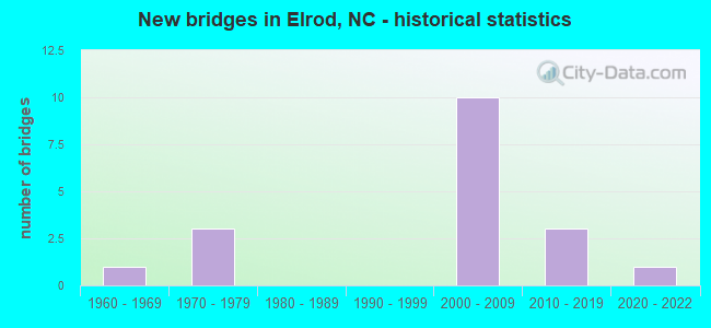
- New bridges - historical statistics
- 11960-1969
- 31970-1979
- 102000-2009
- 32010-2019
- 12020-2022


- Bridge Condition - Deck
- 22.2%Excellent
- 11.1%Very good
- 55.6%Good
- 11.1%Satisfactory

- Bridge Condition - Superstructure
- 22.2%Excellent
- 55.6%Very good
- 22.2%Good

- Bridge Condition - Substructure
- 11.1%Excellent
- 66.7%Very good
- 11.1%Good
- 11.1%Satisfactory

- Bridge Condition - Channel
- 28.6%Very good
- 42.9%Good
- 14.3%Satisfactory
- 14.3%Fair

- Bridge Condition - Culverts
- 66.7%Good
- 33.3%Satisfactory
Find on map >> Show street view
Structure Number: 1550017, Location: 0.5 MI.N.JCT.SR1154 (Lat: 34.644119, Lng: -79.245522), Route carried "on" structure: State highway 710, Year Built: 2002, Status: Open, Structure Length: 2.65m (8.69ft), Average Daily Traffic: 4,100 (year 2018), Truck Traffic: 7%, Average Future Daily Traffic: 8,200 (year 2040), Design Load: HS 20+Mod, Features Intersected: BACK SWAMP
Minimum Vertical Clearance: 30+ m (98+ ft), Kilometerpoint: 0.000, Lanes on structure: 2, Owner: State Highway Agency, Approaching Roadway Width: 12.8m (42.0ft), Skew: 1 degrees, Material/Design: Prestressed concrete, Design/Construction: Slab, Number Of Spans In Main Unit: 2, Length of Maximum Span: 17.9m (58.7ft), Curb-To-Curb Width: 12.5m (41.0ft), Out-to-Out Width: 13.7m (44.9ft)
Condition: Deck: Good, Superstructure: Good, Substructure: Good, Channel: Good, Operating Rating: 74.3 metric tons, Method Used To Determine Operating Rating: Load Factor (LF), Inventory Rating: 44.4 metric tons, Method Used To Determine Inventory Rating: Load Factor (LF), Structural Evaluation: Better than present minimum criteria, Deck Geometry: Equal to present minimum criteria, Waterway Adequacy: Better than present minimum criteria, Approach Roadway Alignment: Equal to present desirable criteria, Designated Inspection Frequency: Every 24 months, Inspection Date: December 2020, Deck Structure Type: Concrete Precast Panels, Wearing Surface/Protective System: Wearing Surface: Bituminous
Find on map >> Show street view
Structure Number: 1550096, Location: 0.6 MI.E.JCT.SR2519 (Lat: 34.542228, Lng: -79.226556), Route carried "on" structure: State highway 1155, Year Built: 1973, Status: Open, Structure Length: 7.89m (25.89ft), Average Daily Traffic: 270 (year 2017), Truck Traffic: 6%, Average Future Daily Traffic: 540 (year 2040), Design Load: HS 15, Features Intersected: I95
Minimum Vertical Clearance: 30+ m (98+ ft), Kilometerpoint: 0.000, Lanes on structure: 2, Lanes under structure: 4, Owner: State Highway Agency, Approaching Roadway Width: 5.7m (18.7ft), Skew: 1 degrees, Material/Design: Steel, Design/Construction: Stringer/Multi-beam, Number Of Spans In Main Unit: 4, Number Of Approach Spans: 2, Length of Maximum Span: 28.6m (93.8ft), Curb-To-Curb Width: 9.5m (31.2ft), Out-to-Out Width: 10.3m (33.8ft)
Condition: Deck: Satisfactory, Superstructure: Very good, Substructure: Satisfactory, Operating Rating: 52.6 metric tons, Method Used To Determine Operating Rating: Load Factor (LF), Inventory Rating: 31.7 metric tons, Method Used To Determine Inventory Rating: Load Factor (LF), Structural Evaluation: Equal to present minimum criteria, Deck Geometry: Equal to present minimum criteria, Underclear: Equal to present minimum criteria, Approach Roadway Alignment: Equal to present desirable criteria, Designated Inspection Frequency: Every 24 months, Inspection Date: April 2021, Deck Structure Type: Concrete Cast-file-Place, Wearing Surface/Protective System: Wearing Surface: Epoxy Overlay, Membrane: Epoxy
Find on map >> Show street view
Structure Number: 1550098, Location: 0.5 MI. S. OF JCT. SR2455 (Lat: 34.548686, Lng: -79.207108), Route carried "on" structure: Interstate 95, Year Built: 1960, Status: Open, Structure Length: 0.64m (2.10ft), Average Daily Traffic: 39,000 (year 2019), Truck Traffic: 23%, Average Future Daily Traffic: 78,000 (year 2040), Design Load: HS 20+Mod, Features Intersected: AARON SWAMP
Minimum Vertical Clearance: 30+ m (98+ ft), Kilometerpoint: 2.042, Lanes on structure: 4, Base Highway Network: Yes (Inventory Route: 1, Subroute: 95), Owner: State Highway Agency, Approaching Roadway Width: 18.8m (61.7ft), Material/Design: Concrete continuous, Design/Construction: Culvert, Number Of Spans In Main Unit: 2, Length of Maximum Span: 3.0m (9.8ft)
Condition: Channel: Satisfactory, Culverts: Satisfactory, Operating Rating: 41.7 metric tons, Method Used To Determine Operating Rating: Field evaluation and documented engineering judgment, Inventory Rating: 32.6 metric tons, Method Used To Determine Inventory Rating: Field evaluation and documented engineering judgment, Structural Evaluation: Equal to present minimum criteria, Waterway Adequacy: Better than present minimum criteria, Approach Roadway Alignment: Equal to present desirable criteria, Designated Inspection Frequency: Every 24 months, Underwater Inspection Frequency: Every 60 months, Inspection Date: November 2020, Underwater Inspection Date: November 2020
Find on map >> Show street view
Structure Number: 1550135, Location: 0.5 MI. W. JCT. SR2455 (Lat: 34.555250, Lng: -79.207150), Route carried "on" structure: State highway 2519, Year Built: 2019, Status: Open, Structure Length: 2.89m (9.48ft), Average Daily Traffic: 1,050 (year 2018), Truck Traffic: 6%, Average Future Daily Traffic: 2,100 (year 2040), Design Load: HL 93, Features Intersected: AARON SWAMP
Minimum Vertical Clearance: 30+ m (98+ ft), Kilometerpoint: 0.000, Lanes on structure: 2, Owner: State Highway Agency, Approaching Roadway Width: 9.4m (30.8ft), Material/Design: Prestressed concrete, Design/Construction: Slab, Number Of Spans In Main Unit: 2, Length of Maximum Span: 15.8m (51.8ft), Curb-To-Curb Width: 9.2m (30.2ft), Out-to-Out Width: 10.0m (32.8ft)
Condition: Deck: Excellent, Superstructure: Excellent, Substructure: Very good, Channel: Very good, Operating Rating: 61.6 metric tons, Method Used To Determine Operating Rating: Load and Resistance Factor (LRFR), Inventory Rating: 42.6 metric tons, Method Used To Determine Inventory Rating: Load and Resistance Factor (LRFR), Structural Evaluation: Equal to present desirable criteria, Deck Geometry: Somewhat better than minimum adequacy, Waterway Adequacy: Equal to present desirable criteria, Approach Roadway Alignment: Equal to present desirable criteria, Designated Inspection Frequency: Every 24 months, Underwater Inspection Frequency: Every 60 months, Inspection Date: August 2021, Underwater Inspection Date: March 2020, Deck Structure Type: Concrete Precast Panels, Wearing Surface/Protective System: Wearing Surface: Bituminous, Deck Protection: Epoxy Coated Reinforcing
Find on map >> Show street view
Structure Number: 1550143, Location: 0.1 MI.E.JCT.SR1148 (Lat: 34.586969, Lng: -79.245672), Route carried "on" structure: State highway 1146, Year Built: 2012, Status: Open, Structure Length: 1.88m (6.17ft), Average Daily Traffic: 530 (year 2017), Truck Traffic: 6%, Average Future Daily Traffic: 1,060 (year 2040), Design Load: HS 25 or greater, Features Intersected: ASHPOLE SWAMP
Minimum Vertical Clearance: 30+ m (98+ ft), Kilometerpoint: 0.000, Lanes on structure: 2, Owner: State Highway Agency, Approaching Roadway Width: 9.1m (29.9ft), Material/Design: Prestressed concrete, Design/Construction: Slab, Number Of Spans In Main Unit: 1, Length of Maximum Span: 17.6m (57.7ft), Curb-To-Curb Width: 9.2m (30.2ft), Out-to-Out Width: 10.0m (32.8ft)
Condition: Deck: Very good, Superstructure: Very good, Substructure: Very good, Channel: Good, Operating Rating: 86.1 metric tons, Method Used To Determine Operating Rating: Load Factor (LF), Inventory Rating: 51.7 metric tons, Method Used To Determine Inventory Rating: Load Factor (LF), Structural Evaluation: Equal to present desirable criteria, Deck Geometry: Equal to present minimum criteria, Waterway Adequacy: Better than present minimum criteria, Approach Roadway Alignment: Equal to present desirable criteria, Designated Inspection Frequency: Every 24 months, Inspection Date: January 2021, Deck Structure Type: Concrete Precast Panels, Wearing Surface/Protective System: Wearing Surface: Bituminous, Deck Protection: Epoxy Coated Reinforcing
Find on map >> Show street view
Structure Number: 1550432, Location: 0.5 MI. N. JCT. SR1154 (Lat: 34.624975, Lng: -79.214472), Route carried "on" structure: State highway 1157, Year Built: 2020, Status: Open, Structure Length: 2.65m (8.69ft), Average Daily Traffic: 100 (year 2018), Truck Traffic: 6%, Average Future Daily Traffic: 200 (year 2040), Design Load: HL 93, Features Intersected: BACK SWAMP CANAL
Minimum Vertical Clearance: 30+ m (98+ ft), Kilometerpoint: 0.000, Lanes on structure: 2, Owner: State Highway Agency, Approaching Roadway Width: 6.4m (21.0ft), Material/Design: Prestressed concrete, Design/Construction: Slab, Number Of Spans In Main Unit: 2, Length of Maximum Span: 16.4m (53.8ft), Curb-To-Curb Width: 8.9m (29.2ft), Out-to-Out Width: 10.0m (32.8ft)
Condition: Deck: Excellent, Superstructure: Excellent, Substructure: Excellent, Channel: Very good, Operating Rating: 49.8 metric tons, Method Used To Determine Operating Rating: Load and Resistance Factor (LRFR), Inventory Rating: 38.1 metric tons, Method Used To Determine Inventory Rating: Load and Resistance Factor (LRFR), Structural Evaluation: Superior to present desirable criteria, Deck Geometry: Better than present minimum criteria, Waterway Adequacy: Equal to present desirable criteria, Approach Roadway Alignment: Equal to present desirable criteria, Designated Inspection Frequency: Every 24 months, Inspection Date: Febuary 2022, Deck Structure Type: Concrete Precast Panels, Wearing Surface/Protective System: Wearing Surface: Bituminous
Find on map >> Show street view
Structure Number: 1550478, Location: 2.8 MI.E. JCT. SR1166 (Lat: 34.650586, Lng: -79.244489), Route carried "on" structure: Interstate 74, Year Built: 2009, Status: Open, Structure Length: 5.97m (19.59ft), Average Daily Traffic: 8,000 (year 2019), Truck Traffic: 23%, Average Future Daily Traffic: 16,000 (year 2040), Design Load: HS 20+Mod, Features Intersected: NC710
Minimum Vertical Clearance: 30+ m (98+ ft), Kilometerpoint: 60.899, Lanes on structure: 3, Lanes under structure: 2, Base Highway Network: Yes (Inventory Route: 1, Subroute: 74), Owner: State Highway Agency, Approaching Roadway Width: 14.3m (46.9ft), Skew: 4 degrees, Material/Design: Steel, Design/Construction: Stringer/Multi-beam, Number Of Spans In Main Unit: 1, Length of Maximum Span: 56.6m (185.7ft), Curb-To-Curb Width: 14.3m (46.9ft), Out-to-Out Width: 15.3m (50.2ft)
Condition: Deck: Good, Superstructure: Very good, Substructure: Very good, Operating Rating: 68.9 metric tons, Method Used To Determine Operating Rating: Load Factor (LF), Inventory Rating: 40.8 metric tons, Method Used To Determine Inventory Rating: Load Factor (LF), Structural Evaluation: Equal to present desirable criteria, Deck Geometry: Meets minimum limits, Underclear: Equal to present minimum criteria, Approach Roadway Alignment: Equal to present desirable criteria, Designated Inspection Frequency: Every 24 months, Inspection Date: May 2021, Deck Structure Type: Concrete Cast-file-Place, Wearing Surface/Protective System: Wearing Surface: Monolithic Concrete, Deck Protection: Epoxy Coated Reinforcing
Find on map >> Show street view
Structure Number: 1550479, Location: 2.8 MI. E. JCT. SR1166 (Lat: 34.650175, Lng: -79.244553), Route carried "on" structure: Interstate 74, Year Built: 2009, Status: Open, Structure Length: 5.94m (19.49ft), Average Daily Traffic: 8,000 (year 2019), Truck Traffic: 23%, Average Future Daily Traffic: 16,000 (year 2040), Design Load: HS 20+Mod, Features Intersected: NC710
Minimum Vertical Clearance: 30+ m (98+ ft), Kilometerpoint: 60.899, Lanes on structure: 3, Lanes under structure: 2, Base Highway Network: Yes (Inventory Route: 9, Subroute: 74), Owner: State Highway Agency, Approaching Roadway Width: 14.6m (47.9ft), Skew: 14 degrees, Material/Design: Steel, Design/Construction: Stringer/Multi-beam, Number Of Spans In Main Unit: 1, Length of Maximum Span: 56.6m (185.7ft), Curb-To-Curb Width: 14.3m (46.9ft), Out-to-Out Width: 15.3m (50.2ft)
Condition: Deck: Good, Superstructure: Very good, Substructure: Very good, Operating Rating: 68.0 metric tons, Method Used To Determine Operating Rating: Load Factor (LF), Inventory Rating: 40.8 metric tons, Method Used To Determine Inventory Rating: Load Factor (LF), Structural Evaluation: Equal to present desirable criteria, Deck Geometry: Meets minimum limits, Underclear: Equal to present minimum criteria, Approach Roadway Alignment: Equal to present desirable criteria, Designated Inspection Frequency: Every 24 months, Inspection Date: May 2021, Deck Structure Type: Concrete Cast-file-Place, Wearing Surface/Protective System: Wearing Surface: Monolithic Concrete, Deck Protection: Epoxy Coated Reinforcing
Find on map >> Show street view
Structure Number: 1550481, Location: 1.5 MI. E. JCT. NC710 (Lat: 34.632761, Lng: -79.228114), Route carried "on" structure: Interstate 74, Year Built: 2010, Status: Open, Structure Length: 5.09m (16.70ft), Average Daily Traffic: 8,000 (year 2019), Truck Traffic: 23%, Average Future Daily Traffic: 16,000 (year 2040), Design Load: HS 20+Mod, Features Intersected: CSX RAILROAD
Minimum Vertical Clearance: 30+ m (98+ ft), Kilometerpoint: 61.387, Lanes on structure: 2, Base Highway Network: Yes (Inventory Route: 1, Subroute: 74), Owner: State Highway Agency, Approaching Roadway Width: 12.4m (40.7ft), Skew: 2 degrees, Material/Design: Steel, Design/Construction: Stringer/Multi-beam, Number Of Spans In Main Unit: 1, Length of Maximum Span: 49.0m (160.8ft), Curb-To-Curb Width: 12.8m (42.0ft), Out-to-Out Width: 13.5m (44.3ft)
Condition: Deck: Good, Superstructure: Very good, Substructure: Very good, Operating Rating: 58.0 metric tons, Method Used To Determine Operating Rating: Load Factor (LF), Inventory Rating: 34.4 metric tons, Method Used To Determine Inventory Rating: Load Factor (LF), Structural Evaluation: Equal to present desirable criteria, Deck Geometry: Equal to present desirable criteria, Underclear: Superior to present desirable criteria, Approach Roadway Alignment: Equal to present desirable criteria, Designated Inspection Frequency: Every 24 months, Inspection Date: November 2021, Deck Structure Type: Concrete Cast-file-Place, Wearing Surface/Protective System: Wearing Surface: Monolithic Concrete, Deck Protection: Epoxy Coated Reinforcing
Find on map >> Show street view
Structure Number: 1550482, Location: 0.3 MI. N. JCT.SR1154 (Lat: 34.604264, Lng: -79.200256), Route carried "on" structure: State highway 1155, Year Built: 2008, Status: Open, Structure Length: 7.77m (25.49ft), Average Daily Traffic: 1,800 (year 2018), Truck Traffic: 6%, Average Future Daily Traffic: 3,600 (year 2040), Design Load: HS 20+Mod, Features Intersected: I74, US74
Minimum Vertical Clearance: 30+ m (98+ ft), Kilometerpoint: 0.000, Lanes on structure: 4, Lanes under structure: 4, Owner: State Highway Agency, Approaching Roadway Width: 16.1m (52.8ft), Skew: 4 degrees, Material/Design: Steel continuous, Design/Construction: Stringer/Multi-beam, Number Of Spans In Main Unit: 2, Length of Maximum Span: 38.1m (125.0ft), Curb-To-Curb Width: 15.5m (50.9ft), Out-to-Out Width: 16.5m (54.1ft)
Condition: Deck: Good, Superstructure: Good, Substructure: Very good, Operating Rating: 78.9 metric tons, Method Used To Determine Operating Rating: Load Factor (LF), Inventory Rating: 47.1 metric tons, Method Used To Determine Inventory Rating: Load Factor (LF), Structural Evaluation: Better than present minimum criteria, Deck Geometry: Meets minimum limits, Underclear: High priority of corrective action, Approach Roadway Alignment: Equal to present desirable criteria, Designated Inspection Frequency: Every 24 months, Inspection Date: August 2021, Deck Structure Type: Concrete Cast-file-Place, Wearing Surface/Protective System: Wearing Surface: Monolithic Concrete, Deck Protection: Epoxy Coated Reinforcing
Find on map >> Show street view
Structure Number: 1550507, Location: 160 FT. W. JCT. NC710 (Lat: 34.653053, Lng: -79.245122), Route carried "on" structure: Ramp Interstate 74, Year Built: 2009, Status: Open, Structure Length: 0.70m (2.30ft), Average Daily Traffic: 2,550 (year 2017), Truck Traffic: 23%, Average Future Daily Traffic: 5,100 (year 2040), Design Load: HS 20+Mod, Features Intersected: DOUBLE BRANCH
Minimum Vertical Clearance: 30+ m (98+ ft), Kilometerpoint: 0.000, Lanes on structure: 2, Base Highway Network: Yes (Inventory Route: 2, Subroute: 74), Owner: State Highway Agency, Approaching Roadway Width: 14.6m (47.9ft), Skew: 3 degrees, Material/Design: Concrete continuous, Design/Construction: Culvert, Number Of Spans In Main Unit: 2, Length of Maximum Span: 3.3m (10.8ft)
Condition: Channel: Good, Culverts: Good, Operating Rating: 89.8 metric tons, Method Used To Determine Operating Rating: Load and Resistance Factor (LRFR), Inventory Rating: 86.1 metric tons, Method Used To Determine Inventory Rating: Load and Resistance Factor (LRFR), Structural Evaluation: Better than present minimum criteria, Waterway Adequacy: Better than present minimum criteria, Approach Roadway Alignment: Equal to present desirable criteria, Designated Inspection Frequency: Every 24 months, Inspection Date: May 2021
Find on map >> Show street view
Structure Number: 1550509, Location: 0.3 MI.E.JCT.NC710 (Lat: 34.645281, Lng: -79.239933), Route carried "on" structure: Interstate 74, Year Built: 2009, Status: Open, Structure Length: 1.09m (3.58ft), Average Daily Traffic: 16,000 (year 2019), Truck Traffic: 23%, Average Future Daily Traffic: 32,000 (year 2040), Design Load: HS 20+Mod, Features Intersected: BACK SWAMP CREEK
Minimum Vertical Clearance: 30+ m (98+ ft), Kilometerpoint: 61.021, Lanes on structure: 4, Base Highway Network: Yes (Inventory Route: 1, Subroute: 74), Owner: State Highway Agency, Approaching Roadway Width: 14.6m (47.9ft), Skew: 3 degrees, Material/Design: Concrete continuous, Design/Construction: Culvert, Number Of Spans In Main Unit: 3, Length of Maximum Span: 3.3m (10.8ft)
Condition: Channel: Fair, Culverts: Good, Operating Rating: 87.9 metric tons, Method Used To Determine Operating Rating: Load and Resistance Factor (LRFR), Inventory Rating: 67.1 metric tons, Method Used To Determine Inventory Rating: Load and Resistance Factor (LRFR), Structural Evaluation: Better than present minimum criteria, Waterway Adequacy: Better than present minimum criteria, Approach Roadway Alignment: Equal to present desirable criteria, Designated Inspection Frequency: Every 24 months, Inspection Date: May 2021
Find on map >> Show street view
Structure Number: 1550096, Location: 0.6 MI.E.JCT.SR2519 (Lat: 34.542228, Lng: -79.226556), Route carried "under" structure: Interstate 95, Year Built: 1973, Structure Length: 0. m, Average Daily Traffic: 19,500 (year 2019), Truck Traffic: 23%, Features Intersected: SR1155
Minimum Vertical Clearance: 5.20m (17.06ft), Kilometerpoint: 1.676, Lanes on structure: 2, Lanes under structure: 2, Material/Design: Steel, Design/Construction: Stringer/Multi-beam, Length of Maximum Span: 28.6m (93.8ft)
Find on map >> Show street view
Structure Number: 1550096, Location: 0.6 MI.E.JCT.SR2519 (Lat: 34.542228, Lng: -79.226556), Route carried "under" structure: Interstate 95, Year Built: 1973, Structure Length: 0. m, Average Daily Traffic: 19,500 (year 2019), Truck Traffic: 23%, Features Intersected: SR1155
Minimum Vertical Clearance: 5.05m (16.57ft), Kilometerpoint: 1.676, Lanes on structure: 2, Lanes under structure: 2, Material/Design: Steel, Design/Construction: Stringer/Multi-beam, Length of Maximum Span: 28.6m (93.8ft)
Find on map >> Show street view
Structure Number: 1550478, Location: 2.8 MI.E. JCT. SR1166 (Lat: 34.650586, Lng: -79.244489), Route carried "under" structure: State highway 710, Year Built: 2009, Structure Length: 0. m, Average Daily Traffic: 4,100 (year 2018), Truck Traffic: 8%, Features Intersected: I74 WBL
Minimum Vertical Clearance: 4.85m (15.91ft), Kilometerpoint: 0.000, Lanes on structure: 3, Lanes under structure: 2, Material/Design: Steel, Design/Construction: Stringer/Multi-beam, Length of Maximum Span: 56.6m (185.7ft)
Find on map >> Show street view
Structure Number: 1550479, Location: 2.8 MI. E. JCT. SR1166 (Lat: 34.650175, Lng: -79.244553), Route carried "under" structure: State highway 710, Year Built: 2009, Structure Length: 0. m, Average Daily Traffic: 3,100 (year 2015), Truck Traffic: 8%, Features Intersected: I74,US74
Minimum Vertical Clearance: 5.08m (16.67ft), Kilometerpoint: 0.000, Lanes on structure: 3, Lanes under structure: 2, Material/Design: Steel, Design/Construction: Stringer/Multi-beam, Length of Maximum Span: 56.6m (185.7ft)
Find on map >> Show street view
Structure Number: 1550482, Location: 0.3 MI. N. JCT.SR1154 (Lat: 34.604264, Lng: -79.200256), Route carried "under" structure: Interstate 74, Year Built: 2008, Structure Length: 0. m, Average Daily Traffic: 8,000 (year 2019), Truck Traffic: 23%, Features Intersected: SR1155
Minimum Vertical Clearance: 5.68m (18.64ft), Kilometerpoint: 62.149, Lanes on structure: 4, Lanes under structure: 2, Material/Design: Steel continuous, Design/Construction: Stringer/Multi-beam, Length of Maximum Span: 38.1m (125.0ft)
Find on map >> Show street view
Structure Number: 1550482, Location: 0.3 MI. N. JCT.SR1154 (Lat: 34.604264, Lng: -79.200256), Route carried "under" structure: Interstate 74, Year Built: 2008, Structure Length: 0. m, Average Daily Traffic: 8,000 (year 2019), Truck Traffic: 23%, Features Intersected: SR1155
Minimum Vertical Clearance: 5.71m (18.73ft), Kilometerpoint: 62.149, Lanes on structure: 4, Lanes under structure: 2, Material/Design: Steel continuous, Design/Construction: Stringer/Multi-beam, Length of Maximum Span: 38.1m (125.0ft)