Bridge Statistics for Elton, Louisiana (LA)
Condition, Traffic, Stress, Structural Evaluation, Project Costs
- National Bridge Inventory (NBI) Statistics
- 11Number of bridges
- 92ft / 27.8mTotal length
- 7,418Total average daily traffic
- 844Total average daily truck traffic
- 7,794Total future (year 2036) average daily traffic
- National Bridge Inventory (NBI) Registered Bridges for Elton
- No street view available for this location
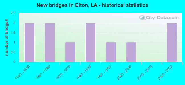
- New bridges - historical statistics
- 21950-1959
- 21960-1969
- 11970-1979
- 21980-1989
- 11990-1999
- 12000-2009
- 22020-2022

- Bridge Condition - Deck
- 57.1%Good
- 42.9%Satisfactory

- Bridge Condition - Superstructure
- 57.1%Good
- 42.9%Satisfactory

- Bridge Condition - Substructure
- 28.6%Good
- 42.9%Satisfactory
- 28.6%Fair

- Bridge Condition - Channel
- 9.1%Very good
- 27.3%Good
- 27.3%Satisfactory
- 27.3%Fair
- 9.1%Poor

- Bridge Condition - Culverts
- 25.0%Good
- 75.0%Satisfactory
Find on map >> Show street view
Structure Number: 30102110304431, Location: 1.2 MI N. West OF LA 3067 (Lat: 30.394300, Lng: -92.497500), Route carried "on" structure: State highway 91, Year Built: 1998, Status: Open, Structure Length: 6.10m (20.01ft), Average Daily Traffic: 2,075 (year 2020), Truck Traffic: 13%, Average Future Daily Traffic: 2,283 (year 2040), Design Load: HS 20, Features Intersected: BAYOU MALLET
Minimum Vertical Clearance: 30+ m (98+ ft), Kilometerpoint: 7.075, Lanes on structure: 2, Owner: State Highway Agency, Approaching Roadway Width: 7.3m (24.0ft), Material/Design: Concrete, Design/Construction: Slab, Number Of Spans In Main Unit: 10, Length of Maximum Span: 6.1m (20.0ft), Curb-To-Curb Width: 13.4m (44.0ft), Out-to-Out Width: 13.4m (44.0ft)
Condition: Deck: Good, Superstructure: Good, Substructure: Good, Channel: Very good, Operating Rating: 72.6 metric tons, Method Used To Determine Operating Rating: Load Factor (LF), Inventory Rating: 42.6 metric tons, Method Used To Determine Inventory Rating: Load Factor (LF), Structural Evaluation: Better than present minimum criteria, Deck Geometry: Better than present minimum criteria, Waterway Adequacy: Equal to present desirable criteria, Approach Roadway Alignment: Equal to present minimum criteria, Designated Inspection Frequency: Every 24 months, Inspection Date: May 2021, Deck Structure Type: Concrete Cast-file-Place, Wearing Surface/Protective System: Wearing Surface: Wood or Timber
Find on map >> Show street view
Structure Number: 70200540203711, Location: 3.71 MI. N OF INT US190 (Lat: 30.536219, Lng: -92.671400), Route carried "on" structure: State highway 26, Year Built: 1957, Status: Open, Structure Length: 6.10m (20.01ft), Average Daily Traffic: 1,550 (year 2016), Truck Traffic: 18%, Average Future Daily Traffic: 1,705 (year 2036), Design Load: H 15, Features Intersected: BAYOU BLUE
Minimum Vertical Clearance: 30+ m (98+ ft), Kilometerpoint: 5.966, Lanes on structure: 2, Base Highway Network: Yes (Inventory Route: 54-02-1, Subroute: 10), Owner: State Highway Agency, Approaching Roadway Width: 11.0m (36.1ft), Material/Design: Concrete, Design/Construction: Slab, Number Of Spans In Main Unit: 10, Length of Maximum Span: 6.1m (20.0ft), Curb-To-Curb Width: 7.4m (24.3ft), Out-to-Out Width: 8.8m (28.9ft)
Condition: Deck: Satisfactory, Superstructure: Satisfactory, Substructure: Satisfactory, Channel: Good, Operating Rating: 31.7 metric tons, Method Used To Determine Operating Rating: Load Factor (LF), Inventory Rating: 19.0 metric tons, Method Used To Determine Inventory Rating: Load Factor (LF), Structural Evaluation: Somewhat better than minimum adequacy, Deck Geometry: Meets minimum limits, Waterway Adequacy: Equal to present minimum criteria, Approach Roadway Alignment: Equal to present desirable criteria, Designated Inspection Frequency: Every 24 months, Inspection Date: Febuary 2021, Deck Structure Type: Concrete Cast-file-Place, Wearing Surface/Protective System: Wearing Surface: Bituminous
Find on map >> Show street view
Structure Number: 70230307924241, Location: POWELL RD(1.5M W.INT 347) (Lat: 30.512781, Lng: -92.708089), Route carried "on" structure: County highway , Year Built: 2001, Status: Open, Structure Length: 3.63m (11.91ft), Average Daily Traffic: 446 (year 2019), Average Future Daily Traffic: 491 (year 2039), Design Load: HS 20, Features Intersected: BAYOU BLUE, Facility Carried by Structure: POWELL RD
Minimum Vertical Clearance: 30+ m (98+ ft), Kilometerpoint: 0.000, Lanes on structure: 2, Base Highway Network: Yes, Owner: County Highway Agency, Approaching Roadway Width: 7.3m (24.0ft), Material/Design: Concrete, Design/Construction: Slab, Number Of Spans In Main Unit: 6, Length of Maximum Span: 6.1m (20.0ft), Curb-To-Curb Width: 7.3m (24.0ft), Out-to-Out Width: 8.1m (26.6ft)
Condition: Deck: Good, Superstructure: Good, Substructure: Satisfactory, Channel: Good, Operating Rating: 30.8 metric tons, Method Used To Determine Operating Rating: Load and Resistance Factor Rating (LRFR) rating reported by rating factor(RF) method using HL-93 loadings, Inventory Rating: 24.0 metric tons, Method Used To Determine Inventory Rating: Load and Resistance Factor Rating (LRFR) rating reported by rating factor(RF) method using HL-93 loadings, Structural Evaluation: Equal to present minimum criteria, Deck Geometry: Meets minimum limits, Waterway Adequacy: Equal to present desirable criteria, Approach Roadway Alignment: Equal to present minimum criteria, Designated Inspection Frequency: Every 24 months, Inspection Date: October 2021, Deck Structure Type: Concrete Cast-file-Place
Find on map >> Show street view
Structure Number: 70230319924131, Location: 1.6 MI WEST OF LA 26 (Lat: 30.532619, Lng: -92.688361), Route carried "on" structure: County highway , Year Built: 1974, Status: Open, Structure Length: 2.93m (9.61ft), Average Daily Traffic: 77 (year 2019), Average Future Daily Traffic: 85 (year 2039), Design Load: HS 20, Features Intersected: BLUE BAYOU, Facility Carried by Structure: BELL OIL RD
Minimum Vertical Clearance: 30+ m (98+ ft), Kilometerpoint: 0.000, Lanes on structure: 2, Owner: County Highway Agency, Approaching Roadway Width: 7.6m (24.9ft), Material/Design: Concrete, Design/Construction: Slab, Number Of Spans In Main Unit: 5, Length of Maximum Span: 5.8m (19.0ft), Curb-To-Curb Width: 7.5m (24.6ft), Out-to-Out Width: 8.2m (26.9ft)
Condition: Deck: Satisfactory, Superstructure: Satisfactory, Substructure: Fair, Channel: Satisfactory, Operating Rating: 34.7 metric tons, Method Used To Determine Operating Rating: Load and Resistance Factor Rating (LRFR) rating reported by rating factor(RF) method using HL-93 loadings, Inventory Rating: 26.9 metric tons, Method Used To Determine Inventory Rating: Load and Resistance Factor Rating (LRFR) rating reported by rating factor(RF) method using HL-93 loadings, Structural Evaluation: Somewhat better than minimum adequacy, Deck Geometry: Equal to present minimum criteria, Waterway Adequacy: Equal to present desirable criteria, Approach Roadway Alignment: Equal to present desirable criteria, Designated Inspection Frequency: Every 24 months, Inspection Date: August 2021, Deck Structure Type: Concrete Precast Panels, Wearing Surface/Protective System: Wearing Surface: Bituminous
Find on map >> Show street view
Structure Number: 727000000727, Location: 0.13 MI N OF US 190 (Lat: 30.484419, Lng: -92.705319), Route carried "on" structure: County highway , Year Built: 2020, Status: Open, Structure Length: 3.05m (10.01ft), Average Daily Traffic: 1,320 (year 2017), Average Future Daily Traffic: 1,430 (year 2037), Design Load: Greater than HL93, Features Intersected: RODGERS GULLY, Facility Carried by Structure: POWELL ROAD
Minimum Vertical Clearance: 30+ m (98+ ft), Kilometerpoint: 0.208, Lanes on structure: 2, Owner: Town or Township Highway Agency, Maintenance Responsibility: County Highway Agency, Approaching Roadway Width: 8.5m (27.9ft), Material/Design: Concrete, Design/Construction: Slab, Number Of Spans In Main Unit: 5, Length of Maximum Span: 6.1m (20.0ft), Curb-To-Curb Width: 8.3m (27.2ft), Out-to-Out Width: 9.4m (30.8ft)
Condition: Deck: Satisfactory, Superstructure: Satisfactory, Substructure: Satisfactory, Channel: Fair, Operating Rating: 56.1 metric tons, Method Used To Determine Operating Rating: Load and Resistance Factor Rating (LRFR) rating reported by rating factor(RF) method using HL-93 loadings, Inventory Rating: 43.4 metric tons, Method Used To Determine Inventory Rating: Load and Resistance Factor Rating (LRFR) rating reported by rating factor(RF) method using HL-93 loadings, Structural Evaluation: Equal to present minimum criteria, Deck Geometry: Meets minimum limits, Waterway Adequacy: Better than present minimum criteria, Approach Roadway Alignment: Equal to present desirable criteria, Designated Inspection Frequency: Every 24 months, Inspection Date: Febuary 2022, Deck Structure Type: Concrete Precast Panels
Find on map >> Show street view
Structure Number: 72700000072706, Location: 0.3 MI N OF LA 1130 (Lat: 30.486431, Lng: -92.688169), Route carried "on" structure: County highway , Year Built: 2021, Status: Open, Structure Length: 1.68m (5.51ft), Average Daily Traffic: 100 (year 2021), Average Future Daily Traffic: 110 (year 2041), Design Load: HS 20, Features Intersected: ROGERS GULLY, Facility Carried by Structure: ST. MARY STREET
Minimum Vertical Clearance: 30+ m (98+ ft), Kilometerpoint: 0.270, Lanes on structure: 2, Owner: County Highway Agency, Approaching Roadway Width: 6.1m (20.0ft), Skew: 4 degrees, Material/Design: Wood or Timber, Design/Construction: Stringer/Multi-beam, Number Of Spans In Main Unit: 3, Length of Maximum Span: 5.8m (19.0ft), Curb-To-Curb Width: 6.6m (21.7ft), Out-to-Out Width: 7.3m (24.0ft)
Condition: Deck: Good, Superstructure: Good, Substructure: Good, Channel: Satisfactory, Operating Rating: 34.0 metric tons, Method Used To Determine Operating Rating: Allowable Stress (AS), Inventory Rating: 26.0 metric tons, Method Used To Determine Inventory Rating: Allowable Stress (AS), Structural Evaluation: Equal to present minimum criteria, Deck Geometry: Somewhat better than minimum adequacy, Waterway Adequacy: Equal to present minimum criteria, Approach Roadway Alignment: Equal to present desirable criteria, Designated Inspection Frequency: Every 24 months, Inspection Date: November 2021, Deck Structure Type: Wood or Timber
Find on map >> Show street view
Structure Number: 72708272107261, Location: 7.26 MI NORTH OF LA 102 (Lat: 30.455600, Lng: -92.705500), Route carried "on" structure: State highway 395, Year Built: 1958, Status: Open, Structure Length: 0.94m (3.08ft), Average Daily Traffic: 930 (year 2016), Truck Traffic: 17%, Average Future Daily Traffic: 1,123 (year 2036), Design Load: H 15, Features Intersected: DRAIN
Minimum Vertical Clearance: 30+ m (98+ ft), Kilometerpoint: 11.702, Lanes on structure: 2, Owner: State Highway Agency, Approaching Roadway Width: 9.8m (32.2ft), Material/Design: Concrete, Design/Construction: Culvert, Number Of Spans In Main Unit: 4, Length of Maximum Span: 2.1m (6.9ft), Curb-To-Curb Width: 9.8m (32.2ft), Out-to-Out Width: 13.4m (44.0ft)
Condition: Channel: Fair, Culverts: Satisfactory, Operating Rating: 42.1 metric tons, Method Used To Determine Operating Rating: Load and Resistance Factor Rating (LRFR) rating reported by rating factor(RF) method using HL-93 loadings, Inventory Rating: 32.4 metric tons, Method Used To Determine Inventory Rating: Load and Resistance Factor Rating (LRFR) rating reported by rating factor(RF) method using HL-93 loadings, Structural Evaluation: Equal to present minimum criteria, Deck Geometry: Equal to present minimum criteria, Waterway Adequacy: Equal to present desirable criteria, Approach Roadway Alignment: Equal to present desirable criteria, Designated Inspection Frequency: Every 24 months, Inspection Date: July 2021, Deck Structure Type: Concrete Cast-file-Place
Find on map >> Show street view
Structure Number: 72708272500491, Location: .49 MI NORTH OF US 190 (Lat: 30.482131, Lng: -92.687800), Route carried "on" structure: State highway 1130, Year Built: 1964, Status: Open, Structure Length: 0.67m (2.20ft), Average Daily Traffic: 410 (year 2016), Truck Traffic: 17%, Average Future Daily Traffic: 246 (year 2036), Design Load: H 15, Features Intersected: DRAIN
Minimum Vertical Clearance: 30+ m (98+ ft), Kilometerpoint: 0.785, Lanes on structure: 2, Owner: State Highway Agency, Approaching Roadway Width: 10.1m (33.1ft), Skew: 30 degrees, Material/Design: Concrete, Design/Construction: Culvert, Number Of Spans In Main Unit: 4, Length of Maximum Span: 1.5m (4.9ft)
Condition: Channel: Poor, Culverts: Satisfactory, Operating Rating: 36.0 metric tons, Method Used To Determine Operating Rating: Load and Resistance Factor Rating (LRFR) rating reported by rating factor(RF) method using HL-93 loadings, Inventory Rating: 27.9 metric tons, Method Used To Determine Inventory Rating: Load and Resistance Factor Rating (LRFR) rating reported by rating factor(RF) method using HL-93 loadings, Structural Evaluation: Equal to present minimum criteria, Waterway Adequacy: Equal to present desirable criteria, Approach Roadway Alignment: Equal to present desirable criteria, Designated Inspection Frequency: Every 24 months, Inspection Date: June 2020, Deck Structure Type: Concrete Cast-file-Place
Find on map >> Show street view
Structure Number: 72708272501041, Location: 1.04 MI NORTH OF US 190 (Lat: 30.482000, Lng: -92.678400), Route carried "on" structure: State highway 1130, Year Built: 1964, Status: Open, Structure Length: 0.70m (2.30ft), Average Daily Traffic: 410 (year 2016), Truck Traffic: 17%, Average Future Daily Traffic: 246 (year 2036), Design Load: H 15, Features Intersected: DRAIN
Minimum Vertical Clearance: 30+ m (98+ ft), Kilometerpoint: 1.683, Lanes on structure: 2, Owner: State Highway Agency, Approaching Roadway Width: 10.4m (34.1ft), Material/Design: Concrete, Design/Construction: Culvert, Number Of Spans In Main Unit: 4, Length of Maximum Span: 1.5m (4.9ft), Curb-To-Curb Width: 10.4m (34.1ft), Out-to-Out Width: 10.7m (35.1ft)
Condition: Channel: Fair, Culverts: Satisfactory, Operating Rating: 30.5 metric tons, Method Used To Determine Operating Rating: Load and Resistance Factor Rating (LRFR) rating reported by rating factor(RF) method using HL-93 loadings, Inventory Rating: 23.3 metric tons, Method Used To Determine Inventory Rating: Load and Resistance Factor Rating (LRFR) rating reported by rating factor(RF) method using HL-93 loadings, Structural Evaluation: Equal to present minimum criteria, Deck Geometry: Equal to present minimum criteria, Waterway Adequacy: Equal to present minimum criteria, Approach Roadway Alignment: Equal to present desirable criteria, Designated Inspection Frequency: Every 24 months, Inspection Date: June 2020, Deck Structure Type: Concrete Cast-file-Place
Find on map >> Show street view
Structure Number: 72730263923941, Location: 1.0 MI E of LA 26 (Lat: 30.438350, Lng: -92.655231), Route carried "on" structure: County highway , Year Built: 1987, Status: Open, Structure Length: 0.85m (2.79ft), Average Daily Traffic: 30 (year 2019), Average Future Daily Traffic: 33 (year 2036), Design Load: HS 20, Features Intersected: ROGERS GULLEY, Facility Carried by Structure: DAN BULLER ROAD
Minimum Vertical Clearance: 30+ m (98+ ft), Kilometerpoint: 0.000, Lanes on structure: 2, Owner: County Highway Agency, Approaching Roadway Width: 7.9m (25.9ft), Skew: 7 degrees, Material/Design: Concrete, Design/Construction: Culvert, Number Of Spans In Main Unit: 3, Length of Maximum Span: 2.4m (7.9ft), Curb-To-Curb Width: 8.2m (26.9ft), Out-to-Out Width: 8.8m (28.9ft)
Condition: Channel: Good, Culverts: Good, Operating Rating: 42.1 metric tons, Method Used To Determine Operating Rating: Load and Resistance Factor Rating (LRFR) rating reported by rating factor(RF) method using HL-93 loadings, Inventory Rating: 32.4 metric tons, Method Used To Determine Inventory Rating: Load and Resistance Factor Rating (LRFR) rating reported by rating factor(RF) method using HL-93 loadings, Structural Evaluation: Better than present minimum criteria, Deck Geometry: Equal to present minimum criteria, Waterway Adequacy: Equal to present minimum criteria, Approach Roadway Alignment: Equal to present desirable criteria, Designated Inspection Frequency: Every 24 months, Inspection Date: July 2020, Deck Structure Type: Concrete Cast-file-Place
Find on map >> Show street view
Structure Number: 72730280924321, Location: 1.23 MI. E. OF INT. 37 (Lat: 30.467269, Lng: -92.720089), Route carried "on" structure: County highway , Year Built: 1981, Status: Open, Structure Length: 1.16m (3.81ft), Average Daily Traffic: 70 (year 2019), Average Future Daily Traffic: 42 (year 2036), Design Load: HS 20, Features Intersected: GULLY, Facility Carried by Structure: DOISE ROAD
Minimum Vertical Clearance: 30+ m (98+ ft), Kilometerpoint: 0.000, Lanes on structure: 2, Owner: County Highway Agency, Approaching Roadway Width: 7.9m (25.9ft), Material/Design: Concrete, Design/Construction: Slab, Number Of Spans In Main Unit: 2, Length of Maximum Span: 5.8m (19.0ft), Curb-To-Curb Width: 7.4m (24.3ft), Out-to-Out Width: 8.4m (27.6ft)
Condition: Deck: Good, Superstructure: Good, Substructure: Fair, Channel: Satisfactory, Operating Rating: 33.6 metric tons, Method Used To Determine Operating Rating: Allowable Stress (AS), Inventory Rating: 33.6 metric tons, Method Used To Determine Inventory Rating: Allowable Stress (AS), Structural Evaluation: Somewhat better than minimum adequacy, Deck Geometry: Equal to present minimum criteria, Waterway Adequacy: Equal to present minimum criteria, Approach Roadway Alignment: Better than present minimum criteria, Designated Inspection Frequency: Every 24 months, Inspection Date: September 2020, Deck Structure Type: Concrete Precast Panels