Bridge Statistics for Ely, Iowa (IA)
Condition, Traffic, Stress, Structural Evaluation, Project Costs
- National Bridge Inventory (NBI) Statistics
- 13Number of bridges
- 95ft / 29.0mTotal length
- 12,715Total average daily traffic
- 383Total average daily truck traffic
- 12,715Total future (year 2040) average daily traffic
- National Bridge Inventory (NBI) Registered Bridges for Ely
- No street view available for this location
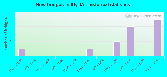
- New bridges - historical statistics
- 11900-1909
- 11950-1959
- 21970-1979
- 41980-1989
- 52000-2009


- Bridge Condition - Deck
- 33.3%Good
- 66.7%Satisfactory

- Bridge Condition - Superstructure
- 33.3%Good
- 44.4%Satisfactory
- 22.2%Fair

- Bridge Condition - Substructure
- 11.1%Very good
- 66.7%Good
- 22.2%Fair

- Bridge Condition - Channel
- 15.4%Very good
- 46.2%Good
- 38.5%Satisfactory

- Bridge Condition - Culverts
- 50.0%Very good
- 50.0%Good
Find on map >> Show street view
Structure Number: 4572, Location: State Street (Lat: 41.871767, Lng: -91.583039), Route carried "on" structure: City street , Year Built: 2001, Status: Open, Structure Length: 1.71m (5.61ft), Average Daily Traffic: 930 (year 2013), Average Future Daily Traffic: 930 (year 2041), Design Load: HS 20, Features Intersected: ROGERS CREEK, Facility Carried by Structure: MAIN ST
Minimum Vertical Clearance: 30+ m (98+ ft), Kilometerpoint: 0.109, Lanes on structure: 2, Owner: City or Municipal Highway Agency, Approaching Roadway Width: 8.2m (26.9ft), Material/Design: Concrete, Design/Construction: Culvert, Number Of Spans In Main Unit: 1, Length of Maximum Span: 7.3m (24.0ft), Curb or Sidewalk Widths: Left: 4.0m (13.1ft), Right: 4.0m (13.1ft), Curb-To-Curb Width: 8.2m (26.9ft), Out-to-Out Width: 8.8m (28.9ft)
Condition: Channel: Good, Culverts: Very good, Operating Rating: 32.3 metric tons, Method Used To Determine Operating Rating: Allowable Stress (AS), Inventory Rating: 32.3 metric tons, Method Used To Determine Inventory Rating: Allowable Stress (AS), Structural Evaluation: Better than present minimum criteria, Deck Geometry: Somewhat better than minimum adequacy, Waterway Adequacy: Somewhat better than minimum adequacy, Approach Roadway Alignment: Equal to present desirable criteria, Designated Inspection Frequency: Every 24 months, Inspection Date: March 2021
Find on map >> Show street view
Structure Number: 4581, Location: 000000000 (Lat: 41.870575, Lng: -91.585033), Route carried "on" structure: City street , Year Built: 2007, Status: Open, Structure Length: 1.10m (3.61ft), Average Daily Traffic: 3,080 (year 2014), Average Future Daily Traffic: 3,080 (year 2041), Design Load: HS 20, Features Intersected: ROGERS CREEK, Facility Carried by Structure: STATE ST
Minimum Vertical Clearance: 30+ m (98+ ft), Kilometerpoint: 0.734, Lanes on structure: 2, Owner: City or Municipal Highway Agency, Approaching Roadway Width: 9.8m (32.2ft), Material/Design: Concrete, Design/Construction: Culvert, Number Of Spans In Main Unit: 1, Length of Maximum Span: 11.0m (36.1ft), Curb-To-Curb Width: 15.7m (51.5ft), Out-to-Out Width: 15.7m (51.5ft)
Condition: Channel: Very good, Culverts: Very good, Operating Rating: 44.4 metric tons, Method Used To Determine Operating Rating: Allowable Stress (AS), Inventory Rating: 32.7 metric tons, Method Used To Determine Inventory Rating: Allowable Stress (AS), Structural Evaluation: Equal to present desirable criteria, Deck Geometry: Superior to present desirable criteria, Waterway Adequacy: Equal to present desirable criteria, Approach Roadway Alignment: Equal to present desirable criteria, Designated Inspection Frequency: Every 24 months, Inspection Date: March 2021, Deck Structure Type: Concrete Cast-file-Place, Wearing Surface/Protective System: Wearing Surface: Monolithic Concrete
Find on map >> Show street view
Structure Number: 4591, Location: 000000000 (Lat: 41.871567, Lng: -91.588497), Route carried "on" structure: City street , Year Built: 1988, Status: Open, Structure Length: 3.90m (12.80ft), Average Daily Traffic: 120 (year 2017), Average Future Daily Traffic: 120 (year 2041), Design Load: HS 20, Features Intersected: HOOSIER CREEK, Facility Carried by Structure: VISTA RD
Minimum Vertical Clearance: 30+ m (98+ ft), Kilometerpoint: 0.824, Lanes on structure: 2, Owner: City or Municipal Highway Agency, Approaching Roadway Width: 9.1m (29.9ft), Skew: 1 degrees, Material/Design: Concrete continuous, Design/Construction: Slab, Number Of Spans In Main Unit: 325, Length of Maximum Span: 14.9m (48.9ft), Curb-To-Curb Width: 9.1m (29.9ft), Out-to-Out Width: 10.1m (33.1ft)
Condition: Deck: Satisfactory, Superstructure: Satisfactory, Substructure: Good, Channel: Good, Operating Rating: 88.2 metric tons, Method Used To Determine Operating Rating: Load Factor (LF), Inventory Rating: 52.9 metric tons, Method Used To Determine Inventory Rating: Load Factor (LF), Structural Evaluation: Equal to present minimum criteria, Deck Geometry: Equal to present minimum criteria, Waterway Adequacy: Better than present minimum criteria, Approach Roadway Alignment: Better than present minimum criteria, Length Of Structure Improvement: 12.80m (41.99ft), Designated Inspection Frequency: Every 24 months, Inspection Date: March 2021, Bridge Improvement Cost: $200,000, Roadway Improvement Cost: $50,000, Deck Structure Type: Concrete Cast-file-Place, Wearing Surface/Protective System: Wearing Surface: Monolithic Concrete, Deck Protection: Epoxy Coated Reinforcing
Find on map >> Show street view
Structure Number: 205431, Location: 081060305 (Lat: 41.860128, Lng: -91.526981), Route carried "on" structure: County highway , Year Built: 1979, Status: Open, Structure Length: 0.82m (2.69ft), Average Daily Traffic: 35 (year 2018), Average Future Daily Traffic: 35 (year 2041), Design Load: HL 93, Features Intersected: LINGLE CREEK, Facility Carried by Structure: SEVEN SIS RD
Minimum Vertical Clearance: 30+ m (98+ ft), Kilometerpoint: 3.993, Lanes on structure: 2, Owner: County Highway Agency, Approaching Roadway Width: 7.0m (23.0ft), Skew: 3 degrees, Material/Design: Concrete continuous, Design/Construction: Culvert, Number Of Spans In Main Unit: 2, Length of Maximum Span: 4.0m (13.1ft)
Condition: Channel: Satisfactory, Culverts: Good, Operating Rating: 46.7 metric tons, Method Used To Determine Operating Rating: Load and Resistance Factor Rating (LRFR) rating reported by rating factor(RF) method using HL-93 loadings, Inventory Rating: 36.0 metric tons, Method Used To Determine Inventory Rating: Load and Resistance Factor Rating (LRFR) rating reported by rating factor(RF) method using HL-93 loadings, Structural Evaluation: Better than present minimum criteria, Waterway Adequacy: Equal to present desirable criteria, Approach Roadway Alignment: Equal to present desirable criteria, Designated Inspection Frequency: Every 24 months, Inspection Date: April 2021
Find on map >> Show street view
Structure Number: 205451, Location: 081060507 (Lat: 41.860333, Lng: -91.579128), Route carried "on" structure: County highway , Year Built: 2005, Status: Open, Structure Length: 2.74m (8.99ft), Average Daily Traffic: 90 (year 2018), Average Future Daily Traffic: 90 (year 2041), Design Load: HS 20, Features Intersected: HOOSIER CREEK, Facility Carried by Structure: SEVEN SIS RD
Minimum Vertical Clearance: 30+ m (98+ ft), Kilometerpoint: 4.768, Lanes on structure: 2, Owner: County Highway Agency, Approaching Roadway Width: 9.8m (32.2ft), Material/Design: Wood or Timber, Design/Construction: Slab, Number Of Spans In Main Unit: 4, Length of Maximum Span: 7.6m (24.9ft), Curb-To-Curb Width: 9.1m (29.9ft), Out-to-Out Width: 9.1m (29.9ft)
Condition: Deck: Good, Superstructure: Good, Substructure: Good, Channel: Satisfactory, Operating Rating: 55.2 metric tons, Method Used To Determine Operating Rating: Allowable Stress (AS), Inventory Rating: 39.3 metric tons, Method Used To Determine Inventory Rating: Allowable Stress (AS), Structural Evaluation: Better than present minimum criteria, Deck Geometry: Better than present minimum criteria, Waterway Adequacy: Equal to present desirable criteria, Approach Roadway Alignment: Meets minimum limits, Designated Inspection Frequency: Every 24 months, Inspection Date: April 2021, Deck Structure Type: Concrete Cast-file-Place, Wearing Surface/Protective System: Wearing Surface: Monolithic Concrete
Find on map >> Show street view
Structure Number: 205461, Location: 081060504 (Lat: 41.857300, Lng: -91.579206), Route carried "on" structure: County highway , Year Built: 2000, Status: Open, Structure Length: 0.67m (2.20ft), Average Daily Traffic: 40 (year 2021), Truck Traffic: 18%, Average Future Daily Traffic: 40 (year 2041), Design Load: HL 93, Features Intersected: HOOSIER CR, Facility Carried by Structure: NAPLES AVE
Minimum Vertical Clearance: 30+ m (98+ ft), Kilometerpoint: 17.357, Lanes on structure: 2, Owner: County Highway Agency, Approaching Roadway Width: 6.1m (20.0ft), Material/Design: Concrete continuous, Design/Construction: Culvert, Number Of Spans In Main Unit: 2, Length of Maximum Span: 3.0m (9.8ft)
Condition: Channel: Satisfactory, Culverts: Good, Operating Rating: 46.7 metric tons, Method Used To Determine Operating Rating: Load and Resistance Factor Rating (LRFR) rating reported by rating factor(RF) method using HL-93 loadings, Inventory Rating: 36.0 metric tons, Method Used To Determine Inventory Rating: Load and Resistance Factor Rating (LRFR) rating reported by rating factor(RF) method using HL-93 loadings, Structural Evaluation: Better than present minimum criteria, Waterway Adequacy: Equal to present desirable criteria, Approach Roadway Alignment: Equal to present desirable criteria, Designated Inspection Frequency: Every 48 months, Inspection Date: April 2021
Find on map >> Show street view
Structure Number: 20549, Location: 081060509 (Lat: 41.848047, Lng: -91.567675), Route carried "on" structure: County highway , Year Built: 1900, Year Reconstructed: 1993, Status: Open, Structure Length: 4.66m (15.29ft), Average Daily Traffic: 1,890 (year 2018), Truck Traffic: 12%, Average Future Daily Traffic: 1,890 (year 2041), Design Load: HS 20, Features Intersected: HOOSIER CREEK, Facility Carried by Structure: FM 120TH ST
Minimum Vertical Clearance: 30+ m (98+ ft), Kilometerpoint: 19.777, Lanes on structure: 2, Owner: County Highway Agency, Approaching Roadway Width: 10.4m (34.1ft), Material/Design: Steel continuous, Design/Construction: Stringer/Multi-beam, Number Of Spans In Main Unit: 3, Length of Maximum Span: 18.0m (59.1ft), Curb-To-Curb Width: 9.1m (29.9ft), Out-to-Out Width: 10.1m (33.1ft)
Condition: Deck: Satisfactory, Superstructure: Fair, Substructure: Good, Channel: Satisfactory, Operating Rating: 39.0 metric tons, Method Used To Determine Operating Rating: Allowable Stress (AS), Inventory Rating: 26.2 metric tons, Method Used To Determine Inventory Rating: Allowable Stress (AS), Structural Evaluation: Somewhat better than minimum adequacy, Deck Geometry: Somewhat better than minimum adequacy, Waterway Adequacy: Equal to present desirable criteria, Approach Roadway Alignment: Equal to present desirable criteria, Length Of Structure Improvement: 17.50m (57.41ft), Designated Inspection Frequency: Every 24 months, Inspection Date: April 2021, Bridge Improvement Cost: $290,000, Roadway Improvement Cost: $40,000, Deck Structure Type: Concrete Cast-file-Place, Wearing Surface/Protective System: Wearing Surface: Low Slump Concrete, Deck Protection: Epoxy Coated Reinforcing
Find on map >> Show street view
Structure Number: 20551, Location: 081060904 (Lat: 41.843103, Lng: -91.554003), Route carried "on" structure: County highway , Year Built: 1955, Year Reconstructed: 1993, Status: Open, Structure Length: 4.02m (13.19ft), Average Daily Traffic: 4,610 (year 2018), Average Future Daily Traffic: 4,610 (year 2041), Design Load: HS 20, Features Intersected: LINGLE CREEK, Facility Carried by Structure: FM ELY RD
Minimum Vertical Clearance: 30+ m (98+ ft), Kilometerpoint: 2.903, Lanes on structure: 2, Owner: County Highway Agency, Approaching Roadway Width: 10.4m (34.1ft), Material/Design: Steel continuous, Design/Construction: Stringer/Multi-beam, Number Of Spans In Main Unit: 3, Length of Maximum Span: 18.3m (60.0ft), Curb-To-Curb Width: 9.1m (29.9ft), Out-to-Out Width: 10.1m (33.1ft)
Condition: Deck: Satisfactory, Superstructure: Fair, Substructure: Good, Channel: Satisfactory, Operating Rating: 49.2 metric tons, Method Used To Determine Operating Rating: Load and Resistance Factor Rating (LRFR) rating reported by rating factor(RF) method using HL-93 loadings, Inventory Rating: 37.9 metric tons, Method Used To Determine Inventory Rating: Load and Resistance Factor Rating (LRFR) rating reported by rating factor(RF) method using HL-93 loadings, Structural Evaluation: Somewhat better than minimum adequacy, Deck Geometry: Meets minimum limits, Waterway Adequacy: Equal to present desirable criteria, Approach Roadway Alignment: Equal to present desirable criteria, Length Of Structure Improvement: 16.00m (52.49ft), Designated Inspection Frequency: Every 24 months, Inspection Date: April 2021, Bridge Improvement Cost: $265,000, Roadway Improvement Cost: $35,000, Deck Structure Type: Concrete Cast-file-Place, Wearing Surface/Protective System: Wearing Surface: Low Slump Concrete, Deck Protection: Epoxy Coated Reinforcing
Find on map >> Show street view
Structure Number: 220211, Location: 000000000 (Lat: 41.878731, Lng: -91.574883), Route carried "on" structure: City street , Year Built: 1989, Status: Open, Structure Length: 2.16m (7.09ft), Average Daily Traffic: 100 (year 2017), Average Future Daily Traffic: 100 (year 2041), Design Load: HS 20, Features Intersected: ROGERS CR, Facility Carried by Structure: ROGERS CR RD
Minimum Vertical Clearance: 30+ m (98+ ft), Kilometerpoint: 0.346, Lanes on structure: 2, Owner: City or Municipal Highway Agency, Maintenance Responsibility: County Highway Agency, Approaching Roadway Width: 9.1m (29.9ft), Material/Design: Wood or Timber, Design/Construction: Slab, Number Of Spans In Main Unit: 3, Length of Maximum Span: 7.3m (24.0ft), Curb-To-Curb Width: 7.8m (25.6ft), Out-to-Out Width: 7.8m (25.6ft)
Condition: Deck: Satisfactory, Superstructure: Satisfactory, Substructure: Good, Channel: Good, Operating Rating: 78.5 metric tons, Method Used To Determine Operating Rating: Allowable Stress (AS), Inventory Rating: 58.0 metric tons, Method Used To Determine Inventory Rating: Allowable Stress (AS), Structural Evaluation: Equal to present minimum criteria, Deck Geometry: Equal to present minimum criteria, Waterway Adequacy: Equal to present desirable criteria, Approach Roadway Alignment: Somewhat better than minimum adequacy, Designated Inspection Frequency: Every 24 months, Inspection Date: March 2021, Deck Structure Type: Wood or Timber, Wearing Surface/Protective System: Wearing Surface: Bituminous
Find on map >> Show street view
Structure Number: 220251, Location: 082063406 (Lat: 41.867814, Lng: -91.535269), Route carried "on" structure: County highway , Year Built: 1971, Status: Open, Structure Length: 0.76m (2.49ft), Average Daily Traffic: 40 (year 2017), Average Future Daily Traffic: 40 (year 2040), Design Load: H 20, Features Intersected: FLAMINGO CREEK, Facility Carried by Structure: PALISADES ACCESS
Minimum Vertical Clearance: 30+ m (98+ ft), Kilometerpoint: 0.851, Lanes on structure: 2, Owner: County Highway Agency, Approaching Roadway Width: 6.4m (21.0ft), Material/Design: Concrete, Design/Construction: Tee Beam, Number Of Spans In Main Unit: 1, Length of Maximum Span: 7.3m (24.0ft), Curb-To-Curb Width: 7.3m (24.0ft), Out-to-Out Width: 7.7m (25.3ft)
Condition: Deck: Satisfactory, Superstructure: Satisfactory, Substructure: Fair, Channel: Good, Operating Rating: 30.1 metric tons, Method Used To Determine Operating Rating: Load and Resistance Factor Rating (LRFR) rating reported by rating factor(RF) method using HL-93 loadings, Inventory Rating: 23.3 metric tons, Method Used To Determine Inventory Rating: Load and Resistance Factor Rating (LRFR) rating reported by rating factor(RF) method using HL-93 loadings, Structural Evaluation: Somewhat better than minimum adequacy, Deck Geometry: Equal to present minimum criteria, Waterway Adequacy: Equal to present desirable criteria, Approach Roadway Alignment: Equal to present desirable criteria, Designated Inspection Frequency: Every 24 months, Inspection Date: August 2020, Deck Structure Type: Concrete Cast-file-Place, Wearing Surface/Protective System: Wearing Surface: Monolithic Concrete
Find on map >> Show street view
Structure Number: 220291, Location: 082072502 (Lat: 41.889503, Lng: -91.617597), Route carried "on" structure: County highway , Year Built: 2008, Status: Open, Structure Length: 2.19m (7.19ft), Average Daily Traffic: 140 (year 2017), Average Future Daily Traffic: 140 (year 2040), Design Load: HS 20, Features Intersected: HOOSIER CREEK, Facility Carried by Structure: SPANISH RD
Minimum Vertical Clearance: 30+ m (98+ ft), Kilometerpoint: 3.167, Lanes on structure: 2, Owner: County Highway Agency, Approaching Roadway Width: 9.8m (32.2ft), Material/Design: Wood or Timber, Design/Construction: Slab, Number Of Spans In Main Unit: 3, Length of Maximum Span: 7.3m (24.0ft), Curb-To-Curb Width: 9.1m (29.9ft), Out-to-Out Width: 9.1m (29.9ft)
Condition: Deck: Good, Superstructure: Good, Substructure: Very good, Channel: Very good, Operating Rating: 78.3 metric tons, Method Used To Determine Operating Rating: Allowable Stress (AS), Inventory Rating: 57.9 metric tons, Method Used To Determine Inventory Rating: Allowable Stress (AS), Structural Evaluation: Better than present minimum criteria, Deck Geometry: Equal to present minimum criteria, Waterway Adequacy: Equal to present desirable criteria, Approach Roadway Alignment: Equal to present desirable criteria, Designated Inspection Frequency: Every 24 months, Inspection Date: August 2020, Deck Structure Type: Concrete Cast-file-Place, Wearing Surface/Protective System: Wearing Surface: Monolithic Concrete
Find on map >> Show street view
Structure Number: 220311, Location: 082072603 (Lat: 41.890017, Lng: -91.619942), Route carried "on" structure: County highway , Year Built: 1985, Status: Open, Structure Length: 2.80m (9.19ft), Average Daily Traffic: 1,500 (year 2021), Truck Traffic: 10%, Average Future Daily Traffic: 1,500 (year 2040), Design Load: HS 20, Features Intersected: HOOSIER CREEK, Facility Carried by Structure: WRIGHT BROS BLV
Minimum Vertical Clearance: 30+ m (98+ ft), Kilometerpoint: 9.893, Lanes on structure: 2, Owner: County Highway Agency, Approaching Roadway Width: 12.2m (40.0ft), Skew: 4 degrees, Material/Design: Concrete continuous, Design/Construction: Slab, Number Of Spans In Main Unit: 3, Length of Maximum Span: 10.4m (34.1ft), Curb-To-Curb Width: 9.1m (29.9ft), Out-to-Out Width: 10.1m (33.1ft)
Condition: Deck: Good, Superstructure: Good, Substructure: Good, Channel: Good, Operating Rating: 49.6 metric tons, Method Used To Determine Operating Rating: Allowable Stress (AS), Inventory Rating: 30.8 metric tons, Method Used To Determine Inventory Rating: Allowable Stress (AS), Structural Evaluation: Better than present minimum criteria, Deck Geometry: Somewhat better than minimum adequacy, Waterway Adequacy: Equal to present desirable criteria, Approach Roadway Alignment: Equal to present desirable criteria, Designated Inspection Frequency: Every 24 months, Inspection Date: August 2020, Deck Structure Type: Concrete Cast-file-Place, Wearing Surface/Protective System: Wearing Surface: Monolithic Concrete, Deck Protection: Epoxy Coated Reinforcing
Find on map >> Show street view
Structure Number: 220351, Location: 082073602 (Lat: 41.873281, Lng: -91.617392), Route carried "on" structure: County highway , Year Built: 1987, Status: Open, Structure Length: 1.43m (4.69ft), Average Daily Traffic: 140 (year 2017), Average Future Daily Traffic: 140 (year 2040), Design Load: HS 20, Features Intersected: SOUTH HOOSIER CREEK, Facility Carried by Structure: SPANISH RD
Minimum Vertical Clearance: 30+ m (98+ ft), Kilometerpoint: 1.366, Lanes on structure: 2, Owner: County Highway Agency, Approaching Roadway Width: 6.1m (20.0ft), Material/Design: Wood or Timber, Design/Construction: Stringer/Multi-beam, Number Of Spans In Main Unit: 2, Length of Maximum Span: 6.7m (22.0ft), Curb-To-Curb Width: 7.1m (23.3ft), Out-to-Out Width: 7.2m (23.6ft)
Condition: Deck: Satisfactory, Superstructure: Satisfactory, Substructure: Fair, Channel: Good, Operating Rating: 44.6 metric tons, Method Used To Determine Operating Rating: Allowable Stress (AS), Inventory Rating: 31.4 metric tons, Method Used To Determine Inventory Rating: Allowable Stress (AS), Structural Evaluation: Somewhat better than minimum adequacy, Deck Geometry: Meets minimum limits, Waterway Adequacy: Equal to present desirable criteria, Approach Roadway Alignment: Equal to present desirable criteria, Designated Inspection Frequency: Every 24 months, Inspection Date: August 2020, Deck Structure Type: Wood or Timber, Wearing Surface/Protective System: Wearing Surface: Wood or Timber