Bridge Statistics for Emerson, Georgia (GA)
Condition, Traffic, Stress, Structural Evaluation, Project Costs
- National Bridge Inventory (NBI) Statistics
- 48Number of bridges
- 1,017ft / 310mTotal length
- $97,127,000Total costs
- 1,333,866Total average daily traffic
- 29,088Total average daily truck traffic
- National Bridge Inventory (NBI) Registered Bridges for Emerson
- No street view available for this location
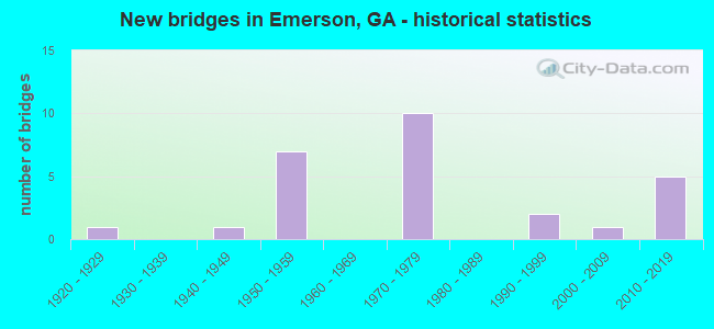
- New bridges - historical statistics
- 11920-1929
- 11940-1949
- 71950-1959
- 101970-1979
- 21990-1999
- 12000-2009
- 52010-2019

- Reconstructed bridges - Historical Statistics
- 11970-1979
- 11980-1989
- 01990-1999
- 02000-2009
- 22010-2019


- Bridge Condition - Deck
- 96.3%Good
- 3.7%Satisfactory

- Bridge Condition - Superstructure
- 11.1%Very good
- 85.2%Good
- 3.7%Fair

- Bridge Condition - Substructure
- 3.7%Very good
- 77.8%Good
- 18.5%Satisfactory

- Bridge Condition - Channel
- 42.9%Very good
- 28.6%Good
- 28.6%Satisfactory
Find on map >> Show street view
Structure Number: 150001, Location: 2.7 MI S OF EMERSON (Lat: 34.090719, Lng: -84.739578), Route carried "on" structure: US 41, Year Built: 1951, Status: Open, Structure Length: 7.83m (25.69ft), Average Daily Traffic: 15,080 (year 2011), Truck Traffic: 1%, Average Future Daily Traffic: 22,620 (year 2031), Design Load: HS 20, Features Intersected: PUMPKINVINE CREEK
Minimum Vertical Clearance: 30+ m (98+ ft), Kilometerpoint: 1.609, Lanes on structure: 2, Base Highway Network: Yes, Owner: State Highway Agency, Approaching Roadway Width: 9.1m (29.9ft), Skew: 19 degrees, Material/Design: Steel, Design/Construction: Stringer/Multi-beam, Number Of Spans In Main Unit: 6, Length of Maximum Span: 13.7m (44.9ft), Curb or Sidewalk Widths: Left: 0.7m (2.3ft), Right: 0.7m (2.3ft), Curb-To-Curb Width: 8.5m (27.9ft), Out-to-Out Width: 10.2m (33.5ft)
Condition: Deck: Good, Superstructure: Good, Substructure: Satisfactory, Channel: Good, Operating Rating: 46.2 metric tons, Method Used To Determine Operating Rating: Load Factor (LF), Inventory Rating: 28.1 metric tons, Method Used To Determine Inventory Rating: Load Factor (LF), Structural Evaluation: Equal to present minimum criteria, Deck Geometry: High priority of corrective action, Waterway Adequacy: Superior to present desirable criteria, Approach Roadway Alignment: Equal to present desirable criteria, Designated Inspection Frequency: Every 24 months, Inspection Date: October 2020, Bridge Improvement Cost: $1,004,000, Roadway Improvement Cost: $100,000, Total Project Cost: $1,506,000, Deck Structure Type: Concrete Cast-file-Place
Find on map >> Show street view
Structure Number: 150002, Location: 2.7 MI S OF EMERSON (Lat: 34.090628, Lng: -84.739750), Route carried "on" structure: US 41, Year Built: 1951, Status: Open, Structure Length: 6.71m (22.01ft), Average Daily Traffic: 15,080 (year 2011), Truck Traffic: 1%, Average Future Daily Traffic: 22,620 (year 2031), Design Load: HS 20, Features Intersected: PUMPKINVINE CREEK
Minimum Vertical Clearance: 30+ m (98+ ft), Kilometerpoint: 1.609, Lanes on structure: 2, Base Highway Network: Yes, Owner: State Highway Agency, Approaching Roadway Width: 8.5m (27.9ft), Skew: 19 degrees, Material/Design: Steel, Design/Construction: Stringer/Multi-beam, Number Of Spans In Main Unit: 5, Length of Maximum Span: 18.3m (60.0ft), Curb or Sidewalk Widths: Left: 0.7m (2.3ft), Right: 0.7m (2.3ft), Curb-To-Curb Width: 8.5m (27.9ft), Out-to-Out Width: 10.2m (33.5ft)
Condition: Deck: Good, Superstructure: Good, Substructure: Satisfactory, Channel: Good, Operating Rating: 32.6 metric tons, Method Used To Determine Operating Rating: Load Factor (LF), Inventory Rating: 21.7 metric tons, Method Used To Determine Inventory Rating: Load Factor (LF), Structural Evaluation: Somewhat better than minimum adequacy, Deck Geometry: High priority of corrective action, Waterway Adequacy: Superior to present desirable criteria, Approach Roadway Alignment: Equal to present desirable criteria, Designated Inspection Frequency: Every 24 months, Inspection Date: October 2020, Bridge Improvement Cost: $860,000, Roadway Improvement Cost: $86,000, Total Project Cost: $1,289,000, Deck Structure Type: Concrete Cast-file-Place
Find on map >> Show street view
Structure Number: 150003, Location: IN SOUTH EMERSON (Lat: 34.111039, Lng: -84.749778), Route carried "on" structure: US 41, Year Built: 1951, Year Reconstructed: 2016, Status: Open, Structure Length: 5.97m (19.59ft), Average Daily Traffic: 15,080 (year 2011), Truck Traffic: 1%, Average Future Daily Traffic: 22,620 (year 2031), Design Load: HS 20, Features Intersected: PUMPKINVINE CREEK
Minimum Vertical Clearance: 30+ m (98+ ft), Kilometerpoint: 4.828, Lanes on structure: 2, Base Highway Network: Yes, Owner: State Highway Agency, Approaching Roadway Width: 8.5m (27.9ft), Skew: 12 degrees, Material/Design: Steel, Design/Construction: Stringer/Multi-beam, Number Of Spans In Main Unit: 4, Length of Maximum Span: 18.0m (59.1ft), Curb or Sidewalk Widths: Left: 0.7m (2.3ft), Right: 0.7m (2.3ft), Curb-To-Curb Width: 8.5m (27.9ft), Out-to-Out Width: 10.2m (33.5ft)
Condition: Deck: Good, Superstructure: Good, Substructure: Satisfactory, Channel: Satisfactory, Operating Rating: 31.7 metric tons, Method Used To Determine Operating Rating: Load Factor (LF), Inventory Rating: 19.9 metric tons, Method Used To Determine Inventory Rating: Load Factor (LF), Structural Evaluation: Somewhat better than minimum adequacy, Deck Geometry: High priority of corrective action, Waterway Adequacy: Superior to present desirable criteria, Approach Roadway Alignment: Equal to present desirable criteria, Designated Inspection Frequency: Every 24 months, Inspection Date: October 2020, Bridge Improvement Cost: $766,000, Roadway Improvement Cost: $77,000, Total Project Cost: $1,149,000, Deck Structure Type: Concrete Cast-file-Place
Find on map >> Show street view
Structure Number: 150004, Location: IN SOUTH EMERSON (Lat: 34.111119, Lng: -84.749969), Route carried "on" structure: US 41, Year Built: 1951, Year Reconstructed: 2016, Status: Open, Structure Length: 6.13m (20.11ft), Average Daily Traffic: 15,080 (year 2011), Truck Traffic: 1%, Average Future Daily Traffic: 22,620 (year 2031), Design Load: HS 20, Features Intersected: PUMPKINVINE CREEK
Minimum Vertical Clearance: 30+ m (98+ ft), Kilometerpoint: 4.828, Lanes on structure: 2, Base Highway Network: Yes, Owner: State Highway Agency, Approaching Roadway Width: 8.8m (28.9ft), Skew: 12 degrees, Material/Design: Steel, Design/Construction: Stringer/Multi-beam, Number Of Spans In Main Unit: 4, Length of Maximum Span: 18.3m (60.0ft), Curb or Sidewalk Widths: Left: 0.7m (2.3ft), Right: 0.7m (2.3ft), Curb-To-Curb Width: 8.5m (27.9ft), Out-to-Out Width: 10.4m (34.1ft)
Condition: Deck: Good, Superstructure: Good, Substructure: Satisfactory, Channel: Satisfactory, Operating Rating: 34.4 metric tons, Method Used To Determine Operating Rating: Load Factor (LF), Inventory Rating: 20.8 metric tons, Method Used To Determine Inventory Rating: Load Factor (LF), Structural Evaluation: Somewhat better than minimum adequacy, Deck Geometry: High priority of corrective action, Waterway Adequacy: Superior to present desirable criteria, Approach Roadway Alignment: Equal to present desirable criteria, Designated Inspection Frequency: Every 24 months, Inspection Date: October 2020, Bridge Improvement Cost: $785,000, Roadway Improvement Cost: $79,000, Total Project Cost: $1,178,000, Deck Structure Type: Concrete Cast-file-Place
Find on map >> Show street view
Structure Number: 150005, Location: IN SOUTH EMERSON (Lat: 34.122347, Lng: -84.749919), Route carried "on" structure: US 41, Year Built: 1951, Status: Open, Structure Length: 7.32m (24.02ft), Average Daily Traffic: 12,130 (year 2012), Truck Traffic: 10%, Average Future Daily Traffic: 18,195 (year 2032), Design Load: HS 20, Features Intersected: SR 293- CSX RR (340429D)
Minimum Vertical Clearance: 30+ m (98+ ft), Kilometerpoint: 4.828, Lanes on structure: 2, Lanes under structure: 2, Base Highway Network: Yes, Owner: State Highway Agency, Approaching Roadway Width: 8.8m (28.9ft), Skew: 13 degrees, Material/Design: Steel continuous, Design/Construction: Stringer/Multi-beam, Number Of Spans In Main Unit: 3, Length of Maximum Span: 29.0m (95.1ft), Curb or Sidewalk Widths: Left: 0.8m (2.6ft), Right: 0.8m (2.6ft), Curb-To-Curb Width: 8.5m (27.9ft), Out-to-Out Width: 10.4m (34.1ft)
Condition: Deck: Good, Superstructure: Good, Substructure: Good, Operating Rating: 40.8 metric tons, Method Used To Determine Operating Rating: Load Factor (LF), Inventory Rating: 24.4 metric tons, Method Used To Determine Inventory Rating: Load Factor (LF), Structural Evaluation: Equal to present minimum criteria, Deck Geometry: High priority of corrective action, Underclear: High priority of corrective action, Approach Roadway Alignment: Equal to present desirable criteria, Designated Inspection Frequency: Every 24 months, Critical Feature Inspection Frequency: Every 12 months, Other Special Inspection Frequency: Every 36 months, Inspection Date: November 2020, Critical Feature Inspection Date: November 2021, Other Special Inspection Date: November 2020, Bridge Improvement Cost: $938,000, Roadway Improvement Cost: $94,000, Total Project Cost: $1,407,000, Deck Structure Type: Concrete Cast-file-Place, Wearing Surface/Protective System: Wearing Surface: Bituminous
Find on map >> Show street view
Structure Number: 150006, Location: IN SOUTH EMERSON (Lat: 34.122439, Lng: -84.750158), Route carried "on" structure: US 41, Year Built: 1951, Status: Open, Structure Length: 7.32m (24.02ft), Average Daily Traffic: 11,980 (year 2011), Truck Traffic: 1%, Average Future Daily Traffic: 17,970 (year 2031), Design Load: HS 20, Features Intersected: SR 293- CSX RR (340429D)
Minimum Vertical Clearance: 30+ m (98+ ft), Kilometerpoint: 4.828, Lanes on structure: 2, Lanes under structure: 2, Base Highway Network: Yes, Owner: State Highway Agency, Approaching Roadway Width: 9.1m (29.9ft), Skew: 13 degrees, Material/Design: Steel continuous, Design/Construction: Stringer/Multi-beam, Number Of Spans In Main Unit: 3, Length of Maximum Span: 29.0m (95.1ft), Curb or Sidewalk Widths: Left: 0.8m (2.6ft), Right: 0.8m (2.6ft), Curb-To-Curb Width: 8.5m (27.9ft), Out-to-Out Width: 10.4m (34.1ft)
Condition: Deck: Good, Superstructure: Good, Substructure: Good, Operating Rating: 40.8 metric tons, Method Used To Determine Operating Rating: Load Factor (LF), Inventory Rating: 24.4 metric tons, Method Used To Determine Inventory Rating: Load Factor (LF), Structural Evaluation: Equal to present minimum criteria, Deck Geometry: High priority of corrective action, Underclear: High priority of corrective action, Approach Roadway Alignment: Equal to present desirable criteria, Designated Inspection Frequency: Every 24 months, Critical Feature Inspection Frequency: Every 12 months, Other Special Inspection Frequency: Every 36 months, Inspection Date: November 2020, Critical Feature Inspection Date: November 2021, Other Special Inspection Date: November 2020, Bridge Improvement Cost: $938,000, Roadway Improvement Cost: $94,000, Total Project Cost: $1,407,000, Deck Structure Type: Concrete Cast-file-Place, Wearing Surface/Protective System: Wearing Surface: Bituminous
Find on map >> Show street view
Structure Number: 150007, Location: 1.8 MI SE OF CARTERSVILLE (Lat: 34.153447, Lng: -84.771169), Route carried "on" structure: US 41, Year Built: 1953, Status: Open, Structure Length: 13.66m (44.82ft), Average Daily Traffic: 16,290 (year 2011), Truck Traffic: 1%, Average Future Daily Traffic: 24,435 (year 2031), Design Load: HS 20, Features Intersected: CR 361- ETOWAH RIVER
Minimum Vertical Clearance: 30+ m (98+ ft), Kilometerpoint: 11.265, Lanes on structure: 4, Lanes under structure: 2, Base Highway Network: Yes, Owner: State Highway Agency, Approaching Roadway Width: 18.3m (60.0ft), Skew: 31 degrees, Material/Design: Steel continuous, Design/Construction: Stringer/Multi-beam, Number Of Spans In Main Unit: 7, Length of Maximum Span: 27.4m (89.9ft), Curb or Sidewalk Widths: Left: 0.7m (2.3ft), Right: 0.7m (2.3ft), Curb-To-Curb Width: 16.9m (55.4ft), Out-to-Out Width: 19.3m (63.3ft)
Condition: Deck: Good, Superstructure: Good, Substructure: Good, Channel: Very good, Operating Rating: 47.1 metric tons, Method Used To Determine Operating Rating: Load Factor (LF), Inventory Rating: 28.1 metric tons, Method Used To Determine Inventory Rating: Load Factor (LF), Structural Evaluation: Better than present minimum criteria, Deck Geometry: Somewhat better than minimum adequacy, Underclear: Better than present minimum criteria, Waterway Adequacy: Superior to present desirable criteria, Approach Roadway Alignment: Equal to present desirable criteria, Designated Inspection Frequency: Every 24 months, Underwater Inspection Frequency: Every 60 months, Inspection Date: October 2020, Underwater Inspection Date: October 2019, Bridge Improvement Cost: $2,705,000, Roadway Improvement Cost: $271,000, Total Project Cost: $4,058,000, Deck Structure Type: Concrete Cast-file-Place
Find on map >> Show street view
Structure Number: 150058, Location: 3.7 MI SE OF EMERSON (Lat: 34.087358, Lng: -84.712608), Route carried "on" structure: City street 9028, Year Built: 1949, Year Reconstructed: 1980, Status: Open, Structure Length: 7.22m (23.69ft), Average Daily Traffic: 5,340 (year 2011), Truck Traffic: 1%, Average Future Daily Traffic: 8,010 (year 2031), Design Load: HS 20+Mod, Features Intersected: ALLATOONA CREEK (LAKE), Facility Carried by Structure: OLD STATE RT. 293
Minimum Vertical Clearance: 30+ m (98+ ft), Kilometerpoint: 1.609, Lanes on structure: 2, Base Highway Network: Yes, Owner: County Highway Agency, Approaching Roadway Width: 7.3m (24.0ft), Skew: 9 degrees, Material/Design: Prestressed concrete, Design/Construction: Stringer/Multi-beam, Number Of Spans In Main Unit: 2, Number Of Approach Spans: 3, Length of Maximum Span: 21.9m (71.9ft), Curb-To-Curb Width: 13.4m (44.0ft), Out-to-Out Width: 14.4m (47.2ft)
Condition: Deck: Good, Superstructure: Good, Substructure: Good, Channel: Very good, Operating Rating: 52.6 metric tons, Method Used To Determine Operating Rating: Load Factor (LF), Inventory Rating: 31.7 metric tons, Method Used To Determine Inventory Rating: Load Factor (LF), Structural Evaluation: Better than present minimum criteria, Deck Geometry: Equal to present minimum criteria, Waterway Adequacy: Equal to present desirable criteria, Approach Roadway Alignment: Equal to present desirable criteria, Designated Inspection Frequency: Every 24 months, Underwater Inspection Frequency: Every 60 months, Inspection Date: September 2020, Underwater Inspection Date: October 2019, Bridge Improvement Cost: $926,000, Roadway Improvement Cost: $93,000, Total Project Cost: $1,389,000, Deck Structure Type: Concrete Cast-file-Place
Find on map >> Show street view
Structure Number: 150061, Location: 2 MI SE OF CARTERSVILLE (Lat: 34.146678, Lng: -84.771228), Route carried "on" structure: State highway 293, Year Built: 1928, Year Reconstructed: 1984, Status: Open, Structure Length: 13.72m (45.01ft), Average Daily Traffic: 6,790 (year 2011), Truck Traffic: 1%, Average Future Daily Traffic: 10,185 (year 2031), Design Load: H 15, Features Intersected: ETOWAH RIVER
Minimum Vertical Clearance: 30+ m (98+ ft), Kilometerpoint: 3.219, Lanes on structure: 2, Base Highway Network: Yes, Owner: State Highway Agency, Approaching Roadway Width: 7.3m (24.0ft), Skew: 3 degrees, Material/Design: Concrete, Design/Construction: Tee Beam, Number Of Spans In Main Unit: 7, Number Of Approach Spans: 2, Length of Maximum Span: 15.8m (51.8ft), Curb-To-Curb Width: 13.4m (44.0ft), Out-to-Out Width: 14.4m (47.2ft)
Condition: Deck: Satisfactory, Superstructure: Fair, Substructure: Satisfactory, Channel: Very good, Operating Rating: 42.6 metric tons, Method Used To Determine Operating Rating: Load Factor (LF), Inventory Rating: 25.4 metric tons, Method Used To Determine Inventory Rating: Load Factor (LF), Structural Evaluation: Somewhat better than minimum adequacy, Deck Geometry: Equal to present minimum criteria, Waterway Adequacy: Superior to present desirable criteria, Approach Roadway Alignment: Equal to present desirable criteria, Designated Inspection Frequency: Every 24 months, Underwater Inspection Frequency: Every 60 months, Inspection Date: October 2020, Underwater Inspection Date: October 2019, Bridge Improvement Cost: $1,758,000, Roadway Improvement Cost: $176,000, Total Project Cost: $2,637,000, Deck Structure Type: Concrete Cast-file-Place, Wearing Surface/Protective System: Wearing Surface: Bituminous
Find on map >> Show street view
Structure Number: 150077, Location: 3.6 MI SE OF EMERSON (Lat: 34.088408, Lng: -84.712900), Route carried "on" structure: Interstate 75, Year Built: 1977, Status: Open, Structure Length: 43.56m (142.91ft), Average Daily Traffic: 83,640 (year 2011), Truck Traffic: 1%, Average Future Daily Traffic: 125,460 (year 2031), Design Load: HS 20+Mod, Features Intersected: CR645-CR397-ALLATOONA LK
Minimum Vertical Clearance: 30+ m (98+ ft), Kilometerpoint: 452.226, Lanes on structure: 3, Lanes under structure: 4, Base Highway Network: Yes, Owner: State Highway Agency, Approaching Roadway Width: 15.8m (51.8ft), Skew: 19 degrees, Material/Design: Steel continuous, Design/Construction: Stringer/Multi-beam, Number Of Spans In Main Unit: 12, Length of Maximum Span: 57.9m (190.0ft), Curb-To-Curb Width: 18.3m (60.0ft), Out-to-Out Width: 19.0m (62.3ft)
Condition: Deck: Good, Superstructure: Good, Substructure: Good, Channel: Very good, Operating Rating: 30.8 metric tons, Method Used To Determine Operating Rating: Load Factor (LF), Inventory Rating: 19.0 metric tons, Method Used To Determine Inventory Rating: Load Factor (LF), Structural Evaluation: Meets minimum limits, Deck Geometry: Better than present minimum criteria, Underclear: Better than present minimum criteria, Waterway Adequacy: Superior to present desirable criteria, Approach Roadway Alignment: Equal to present desirable criteria, Designated Inspection Frequency: Every 24 months, Underwater Inspection Frequency: Every 60 months, Inspection Date: October 2020, Underwater Inspection Date: October 2019, Bridge Improvement Cost: $7,106,000, Roadway Improvement Cost: $711,000, Total Project Cost: $10,659,000, Deck Structure Type: Concrete Cast-file-Place, Wearing Surface/Protective System: Wearing Surface: Epoxy Overlay
Find on map >> Show street view
Structure Number: 150078, Location: 3.6 MI SE OF EMERSON (Lat: 34.088139, Lng: -84.712828), Route carried "on" structure: Interstate 75, Year Built: 1977, Status: Open, Structure Length: 38.62m (126.71ft), Average Daily Traffic: 83,640 (year 2011), Truck Traffic: 1%, Average Future Daily Traffic: 125,460 (year 2031), Design Load: HS 20+Mod, Features Intersected: CR645-CR397-ALLATOONA LK
Minimum Vertical Clearance: 30+ m (98+ ft), Kilometerpoint: 452.226, Lanes on structure: 3, Lanes under structure: 4, Base Highway Network: Yes, Owner: State Highway Agency, Approaching Roadway Width: 15.8m (51.8ft), Skew: 19 degrees, Material/Design: Steel continuous, Design/Construction: Stringer/Multi-beam, Number Of Spans In Main Unit: 10, Length of Maximum Span: 57.9m (190.0ft), Curb-To-Curb Width: 18.3m (60.0ft), Out-to-Out Width: 19.0m (62.3ft)
Condition: Deck: Good, Superstructure: Good, Substructure: Good, Channel: Very good, Operating Rating: 30.8 metric tons, Method Used To Determine Operating Rating: Load Factor (LF), Inventory Rating: 19.0 metric tons, Method Used To Determine Inventory Rating: Load Factor (LF), Structural Evaluation: Meets minimum limits, Deck Geometry: Better than present minimum criteria, Underclear: Equal to present minimum criteria, Waterway Adequacy: Superior to present desirable criteria, Approach Roadway Alignment: Equal to present desirable criteria, Designated Inspection Frequency: Every 24 months, Underwater Inspection Frequency: Every 60 months, Inspection Date: October 2020, Underwater Inspection Date: October 2019, Bridge Improvement Cost: $6,301,000, Roadway Improvement Cost: $630,000, Total Project Cost: $9,451,000, Deck Structure Type: Concrete Cast-file-Place
Find on map >> Show street view
Structure Number: 150079, Location: 3.1 MI SE OF EMERSON (Lat: 34.091019, Lng: -84.723958), Route carried "on" structure: Interstate 75, Year Built: 1977, Status: Open, Structure Length: 4.94m (16.21ft), Average Daily Traffic: 83,640 (year 2011), Truck Traffic: 1%, Average Future Daily Traffic: 125,460 (year 2031), Design Load: HS 20+Mod, Features Intersected: CR 427 JOE STELLA DRIVE
Minimum Vertical Clearance: 30+ m (98+ ft), Kilometerpoint: 453.835, Lanes on structure: 3, Lanes under structure: 2, Base Highway Network: Yes, Owner: State Highway Agency, Approaching Roadway Width: 17.4m (57.1ft), Skew: 19 degrees, Material/Design: Steel, Design/Construction: Stringer/Multi-beam, Number Of Spans In Main Unit: 3, Length of Maximum Span: 18.9m (62.0ft), Curb-To-Curb Width: 18.3m (60.0ft), Out-to-Out Width: 19.0m (62.3ft)
Condition: Deck: Good, Superstructure: Good, Substructure: Good, Operating Rating: 55.3 metric tons, Method Used To Determine Operating Rating: Load Factor (LF), Inventory Rating: 32.6 metric tons, Method Used To Determine Inventory Rating: Load Factor (LF), Structural Evaluation: Better than present minimum criteria, Deck Geometry: Better than present minimum criteria, Underclear: Superior to present desirable criteria, Approach Roadway Alignment: Equal to present desirable criteria, Designated Inspection Frequency: Every 24 months, Inspection Date: October 2020, Bridge Improvement Cost: $806,000, Roadway Improvement Cost: $81,000, Total Project Cost: $1,208,000, Deck Structure Type: Concrete Cast-file-Place, Wearing Surface/Protective System: Wearing Surface: Epoxy Overlay
Find on map >> Show street view
Structure Number: 15008, Location: 3.1 MI SE OF EMERSON (Lat: 34.090908, Lng: -84.724258), Route carried "on" structure: Interstate 75, Year Built: 1977, Status: Open, Structure Length: 5.58m (18.31ft), Average Daily Traffic: 83,640 (year 2011), Truck Traffic: 1%, Average Future Daily Traffic: 125,460 (year 2031), Design Load: HS 20+Mod, Features Intersected: CR 427 JOE STELLA DRIVE
Minimum Vertical Clearance: 30+ m (98+ ft), Kilometerpoint: 453.835, Lanes on structure: 3, Lanes under structure: 2, Base Highway Network: Yes, Owner: State Highway Agency, Approaching Roadway Width: 17.7m (58.1ft), Skew: 19 degrees, Material/Design: Steel, Design/Construction: Stringer/Multi-beam, Number Of Spans In Main Unit: 3, Length of Maximum Span: 19.2m (63.0ft), Curb-To-Curb Width: 18.3m (60.0ft), Out-to-Out Width: 19.0m (62.3ft)
Condition: Deck: Good, Superstructure: Good, Substructure: Good, Operating Rating: 52.6 metric tons, Method Used To Determine Operating Rating: Load Factor (LF), Inventory Rating: 31.7 metric tons, Method Used To Determine Inventory Rating: Load Factor (LF), Structural Evaluation: Better than present minimum criteria, Deck Geometry: Better than present minimum criteria, Underclear: Superior to present desirable criteria, Approach Roadway Alignment: Equal to present desirable criteria, Designated Inspection Frequency: Every 24 months, Inspection Date: October 2020, Bridge Improvement Cost: $910,000, Roadway Improvement Cost: $91,000, Total Project Cost: $1,365,000, Deck Structure Type: Concrete Cast-file-Place, Wearing Surface/Protective System: Wearing Surface: Epoxy Overlay
Find on map >> Show street view
Structure Number: 150081, Location: 1.1 MI SE OF EMERSON (Lat: 34.118608, Lng: -84.739228), Route carried "on" structure: Interstate 75, Year Built: 1976, Status: Open, Structure Length: 8.56m (28.08ft), Average Daily Traffic: 88,590 (year 2011), Truck Traffic: 1%, Average Future Daily Traffic: 132,885 (year 2031), Design Load: HS 20+Mod, Features Intersected: CR 397 ALLATOONA ROAD
Minimum Vertical Clearance: 30+ m (98+ ft), Kilometerpoint: 457.054, Lanes on structure: 3, Lanes under structure: 4, Base Highway Network: Yes, Owner: State Highway Agency, Approaching Roadway Width: 17.1m (56.1ft), Skew: 14 degrees, Material/Design: Steel, Design/Construction: Stringer/Multi-beam, Number Of Spans In Main Unit: 4, Length of Maximum Span: 23.2m (76.1ft), Curb-To-Curb Width: 18.3m (60.0ft), Out-to-Out Width: 19.0m (62.3ft)
Condition: Deck: Good, Superstructure: Good, Substructure: Good, Operating Rating: 62.5 metric tons, Method Used To Determine Operating Rating: Load Factor (LF), Inventory Rating: 37.1 metric tons, Method Used To Determine Inventory Rating: Load Factor (LF), Structural Evaluation: Better than present minimum criteria, Deck Geometry: Better than present minimum criteria, Underclear: Superior to present desirable criteria, Approach Roadway Alignment: Equal to present desirable criteria, Designated Inspection Frequency: Every 24 months, Inspection Date: August 2020, Bridge Improvement Cost: $1,397,000, Roadway Improvement Cost: $140,000, Total Project Cost: $2,096,000, Deck Structure Type: Concrete Cast-file-Place, Wearing Surface/Protective System: Wearing Surface: Epoxy Overlay
Find on map >> Show street view
Structure Number: 150082, Location: 1.1 MI SE OF EMERSON (Lat: 34.118758, Lng: -84.739689), Route carried "on" structure: Interstate 75, Year Built: 1976, Status: Open, Structure Length: 8.41m (27.59ft), Average Daily Traffic: 83,330 (year 2011), Truck Traffic: 1%, Average Future Daily Traffic: 124,995 (year 2031), Design Load: HS 20+Mod, Features Intersected: CR 397 ALLATOONA ROAD
Minimum Vertical Clearance: 30+ m (98+ ft), Kilometerpoint: 457.054, Lanes on structure: 3, Lanes under structure: 4, Base Highway Network: Yes, Owner: State Highway Agency, Approaching Roadway Width: 17.4m (57.1ft), Skew: 14 degrees, Material/Design: Steel, Design/Construction: Stringer/Multi-beam, Number Of Spans In Main Unit: 4, Length of Maximum Span: 22.9m (75.1ft), Curb-To-Curb Width: 18.3m (60.0ft), Out-to-Out Width: 19.0m (62.3ft)
Condition: Deck: Good, Superstructure: Good, Substructure: Good, Operating Rating: 60.7 metric tons, Method Used To Determine Operating Rating: Load Factor (LF), Inventory Rating: 36.2 metric tons, Method Used To Determine Inventory Rating: Load Factor (LF), Structural Evaluation: Better than present minimum criteria, Deck Geometry: Better than present minimum criteria, Underclear: Equal to present minimum criteria, Approach Roadway Alignment: Equal to present desirable criteria, Designated Inspection Frequency: Every 24 months, Inspection Date: August 2020, Bridge Improvement Cost: $1,372,000, Roadway Improvement Cost: $137,000, Total Project Cost: $2,059,000, Deck Structure Type: Concrete Cast-file-Place, Wearing Surface/Protective System: Wearing Surface: Epoxy Overlay
Find on map >> Show street view
Structure Number: 150083, Location: 2.7 MI E OF CARTERSVILLE (Lat: 34.158069, Lng: -84.752039), Route carried "on" structure: Interstate 75, Year Built: 1977, Status: Open, Structure Length: 4.82m (15.81ft), Average Daily Traffic: 84,630 (year 2011), Truck Traffic: 1%, Average Future Daily Traffic: 126,945 (year 2031), Design Load: HS 20+Mod, Features Intersected: M-914
Minimum Vertical Clearance: 30+ m (98+ ft), Kilometerpoint: 461.882, Lanes on structure: 3, Lanes under structure: 2, Base Highway Network: Yes, Owner: State Highway Agency, Approaching Roadway Width: 17.1m (56.1ft), Skew: 11 degrees, Material/Design: Steel, Design/Construction: Stringer/Multi-beam, Number Of Spans In Main Unit: 3, Length of Maximum Span: 21.3m (69.9ft), Curb-To-Curb Width: 18.1m (59.4ft), Out-to-Out Width: 19.0m (62.3ft)
Condition: Deck: Good, Superstructure: Good, Substructure: Good, Operating Rating: 46.2 metric tons, Method Used To Determine Operating Rating: Load Factor (LF), Inventory Rating: 27.2 metric tons, Method Used To Determine Inventory Rating: Load Factor (LF), Structural Evaluation: Equal to present minimum criteria, Deck Geometry: Better than present minimum criteria, Underclear: Superior to present desirable criteria, Approach Roadway Alignment: Equal to present desirable criteria, Designated Inspection Frequency: Every 24 months, Inspection Date: August 2020, Bridge Improvement Cost: $786,000, Roadway Improvement Cost: $79,000, Total Project Cost: $1,179,000, Deck Structure Type: Concrete Cast-file-Place, Wearing Surface/Protective System: Wearing Surface: Epoxy Overlay
Find on map >> Show street view
Structure Number: 150084, Location: 2.7 MI E OF CARTERSVILLE (Lat: 34.157889, Lng: -84.752300), Route carried "on" structure: Interstate 75, Year Built: 1977, Status: Open, Structure Length: 4.82m (15.81ft), Average Daily Traffic: 84,630 (year 2011), Truck Traffic: 1%, Average Future Daily Traffic: 126,945 (year 2031), Design Load: HS 20+Mod, Features Intersected: M-914
Minimum Vertical Clearance: 30+ m (98+ ft), Kilometerpoint: 461.882, Lanes on structure: 3, Lanes under structure: 2, Base Highway Network: Yes, Owner: State Highway Agency, Approaching Roadway Width: 17.1m (56.1ft), Skew: 11 degrees, Material/Design: Steel, Design/Construction: Stringer/Multi-beam, Number Of Spans In Main Unit: 3, Length of Maximum Span: 21.3m (69.9ft), Curb-To-Curb Width: 18.1m (59.4ft), Out-to-Out Width: 19.0m (62.3ft)
Condition: Deck: Good, Superstructure: Good, Substructure: Good, Operating Rating: 46.2 metric tons, Method Used To Determine Operating Rating: Load Factor (LF), Inventory Rating: 27.2 metric tons, Method Used To Determine Inventory Rating: Load Factor (LF), Structural Evaluation: Equal to present minimum criteria, Deck Geometry: Better than present minimum criteria, Underclear: Superior to present desirable criteria, Approach Roadway Alignment: Equal to present desirable criteria, Designated Inspection Frequency: Every 24 months, Inspection Date: August 2020, Bridge Improvement Cost: $786,000, Roadway Improvement Cost: $79,000, Total Project Cost: $1,179,000, Deck Structure Type: Concrete Cast-file-Place, Wearing Surface/Protective System: Wearing Surface: Epoxy Overlay
Find on map >> Show street view
Structure Number: 150085, Location: 2.6 MI E OF CARTERSVILLE (Lat: 34.160058, Lng: -84.753747), Route carried "on" structure: Interstate 75, Year Built: 1977, Status: Open, Structure Length: 18.29m (60.01ft), Average Daily Traffic: 78,730 (year 2011), Truck Traffic: 1%, Average Future Daily Traffic: 118,095 (year 2031), Design Load: HS 20+Mod, Features Intersected: ETOWAH RIVER
Minimum Vertical Clearance: 30+ m (98+ ft), Kilometerpoint: 461.882, Lanes on structure: 3, Base Highway Network: Yes, Owner: State Highway Agency, Approaching Roadway Width: 17.1m (56.1ft), Skew: 14 degrees, Material/Design: Prestressed concrete, Design/Construction: Stringer/Multi-beam, Number Of Spans In Main Unit: 8, Length of Maximum Span: 27.4m (89.9ft), Curb-To-Curb Width: 18.3m (60.0ft), Out-to-Out Width: 19.0m (62.3ft)
Condition: Deck: Good, Superstructure: Good, Substructure: Good, Channel: Very good, Operating Rating: 58.0 metric tons, Method Used To Determine Operating Rating: Load Factor (LF), Inventory Rating: 28.1 metric tons, Method Used To Determine Inventory Rating: Load Factor (LF), Structural Evaluation: Better than present minimum criteria, Deck Geometry: Better than present minimum criteria, Waterway Adequacy: Superior to present desirable criteria, Approach Roadway Alignment: Equal to present desirable criteria, Designated Inspection Frequency: Every 24 months, Underwater Inspection Frequency: Every 60 months, Inspection Date: October 2020, Underwater Inspection Date: October 2019, Bridge Improvement Cost: $2,984,000, Roadway Improvement Cost: $298,000, Total Project Cost: $4,476,000, Deck Structure Type: Concrete Cast-file-Place, Wearing Surface/Protective System: Wearing Surface: Epoxy Overlay
Find on map >> Show street view
Structure Number: 150086, Location: 2.6 MI E OF CARTERSVILLE (Lat: 34.160128, Lng: -84.754219), Route carried "on" structure: Interstate 75, Year Built: 1977, Status: Open, Structure Length: 18.29m (60.01ft), Average Daily Traffic: 78,730 (year 2011), Truck Traffic: 1%, Average Future Daily Traffic: 118,095 (year 2031), Design Load: HS 20+Mod, Features Intersected: ETOWAH RIVER
Minimum Vertical Clearance: 30+ m (98+ ft), Kilometerpoint: 461.882, Lanes on structure: 3, Base Highway Network: Yes, Owner: State Highway Agency, Approaching Roadway Width: 17.1m (56.1ft), Skew: 14 degrees, Material/Design: Prestressed concrete, Design/Construction: Stringer/Multi-beam, Number Of Spans In Main Unit: 8, Length of Maximum Span: 27.4m (89.9ft), Curb-To-Curb Width: 18.3m (60.0ft), Out-to-Out Width: 19.0m (62.3ft)
Condition: Deck: Good, Superstructure: Good, Substructure: Good, Channel: Good, Operating Rating: 58.0 metric tons, Method Used To Determine Operating Rating: Load Factor (LF), Inventory Rating: 28.1 metric tons, Method Used To Determine Inventory Rating: Load Factor (LF), Structural Evaluation: Better than present minimum criteria, Deck Geometry: Better than present minimum criteria, Waterway Adequacy: Superior to present desirable criteria, Approach Roadway Alignment: Equal to present desirable criteria, Designated Inspection Frequency: Every 24 months, Underwater Inspection Frequency: Every 60 months, Inspection Date: October 2020, Underwater Inspection Date: October 2019, Bridge Improvement Cost: $2,984,000, Roadway Improvement Cost: $298,000, Total Project Cost: $4,476,000, Deck Structure Type: Concrete Cast-file-Place, Wearing Surface/Protective System: Wearing Surface: Epoxy Overlay
Find on map >> Show street view
Structure Number: 150137, Location: 2.6 MI S OF EMERSON (Lat: 34.095100, Lng: -84.732919), Route carried "on" structure: County highway 1666, Year Built: 1992, Status: Open, Structure Length: 7.77m (25.49ft), Average Daily Traffic: 5,340 (year 2011), Truck Traffic: 1%, Average Future Daily Traffic: 8,010 (year 2031), Design Load: HS 20+Mod, Features Intersected: PUMPKINVINE CREEK, Facility Carried by Structure: OLD STATE RT. 293
Minimum Vertical Clearance: 30+ m (98+ ft), Kilometerpoint: 3.219, Lanes on structure: 2, Base Highway Network: Yes, Owner: County Highway Agency, Approaching Roadway Width: 7.3m (24.0ft), Skew: 1 degrees, Material/Design: Prestressed concrete, Design/Construction: Stringer/Multi-beam, Number Of Spans In Main Unit: 3, Length of Maximum Span: 25.9m (85.0ft), Curb-To-Curb Width: 12.2m (40.0ft), Out-to-Out Width: 13.2m (43.3ft)
Condition: Deck: Good, Superstructure: Very good, Substructure: Good, Channel: Satisfactory, Operating Rating: 61.6 metric tons, Method Used To Determine Operating Rating: Load Factor (LF), Inventory Rating: 25.4 metric tons, Method Used To Determine Inventory Rating: Load Factor (LF), Structural Evaluation: Equal to present minimum criteria, Deck Geometry: Somewhat better than minimum adequacy, Waterway Adequacy: Equal to present desirable criteria, Approach Roadway Alignment: Equal to present desirable criteria, Designated Inspection Frequency: Every 24 months, Inspection Date: September 2020, Bridge Improvement Cost: $996,000, Roadway Improvement Cost: $100,000, Total Project Cost: $1,495,000, Deck Structure Type: Concrete Cast-file-Place
Find on map >> Show street view
Structure Number: 150138, Location: IN SOUTH EMERSON (Lat: 34.101058, Lng: -84.737278), Route carried "on" structure: County highway 1666, Year Built: 1992, Status: Open, Structure Length: 6.86m (22.51ft), Average Daily Traffic: 1,780 (year 2011), Truck Traffic: 1%, Average Future Daily Traffic: 2,670 (year 2031), Design Load: HS 20+Mod, Features Intersected: PUMPKINVINE CREEK, Facility Carried by Structure: OLD STATE RT. 293
Minimum Vertical Clearance: 30+ m (98+ ft), Kilometerpoint: 3.219, Lanes on structure: 2, Base Highway Network: Yes, Owner: County Highway Agency, Approaching Roadway Width: 7.3m (24.0ft), Skew: 3 degrees, Material/Design: Prestressed concrete, Design/Construction: Stringer/Multi-beam, Number Of Spans In Main Unit: 3, Length of Maximum Span: 22.9m (75.1ft), Curb-To-Curb Width: 12.2m (40.0ft), Out-to-Out Width: 13.2m (43.3ft)
Condition: Deck: Good, Superstructure: Very good, Substructure: Good, Channel: Good, Operating Rating: 65.3 metric tons, Method Used To Determine Operating Rating: Load Factor (LF), Inventory Rating: 35.3 metric tons, Method Used To Determine Inventory Rating: Load Factor (LF), Structural Evaluation: Better than present minimum criteria, Deck Geometry: Better than present minimum criteria, Waterway Adequacy: Equal to present desirable criteria, Approach Roadway Alignment: Equal to present desirable criteria, Designated Inspection Frequency: Every 24 months, Inspection Date: September 2020, Bridge Improvement Cost: $879,000, Roadway Improvement Cost: $88,000, Total Project Cost: $1,319,000, Deck Structure Type: Concrete Cast-file-Place
Find on map >> Show street view
Structure Number: 155113, Location: 1.9 MI SW OF EMERSON (Lat: 34.102739, Lng: -84.766669), Route carried "on" structure: County highway 365, Year Built: 2002, Status: Open, Structure Length: 2.26m (7.41ft), Average Daily Traffic: 1,096 (year 2011), Truck Traffic: 1%, Average Future Daily Traffic: 1,644 (year 2031), Design Load: HS 20+Mod, Features Intersected: PUMPKINVINE CREEK, Facility Carried by Structure: PUCKETT ROAD
Minimum Vertical Clearance: 30+ m (98+ ft), Kilometerpoint: 0.000, Lanes on structure: 1, Base Highway Network: Yes, Owner: County Highway Agency, Approaching Roadway Width: 4.9m (16.1ft), Material/Design: Steel, Design/Construction: Truss - Thru, Number Of Spans In Main Unit: 1, Length of Maximum Span: 22.6m (74.1ft), Curb-To-Curb Width: 3.6m (11.8ft), Out-to-Out Width: 3.7m (12.1ft)
Condition: Deck: Good, Superstructure: Very good, Substructure: Good, Channel: Satisfactory, Operating Rating: 63.5 metric tons, Method Used To Determine Operating Rating: Load Factor (LF), Inventory Rating: 38.1 metric tons, Method Used To Determine Inventory Rating: Load Factor (LF), Structural Evaluation: Better than present minimum criteria, Deck Geometry: High priority of replacement, Waterway Adequacy: Somewhat better than minimum adequacy, Approach Roadway Alignment: Meets minimum limits, Designated Inspection Frequency: Every 24 months, Critical Feature Inspection Frequency: Every 24 months, Inspection Date: August 2020, Critical Feature Inspection Date: August 2021, Bridge Improvement Cost: $210,000, Roadway Improvement Cost: $21,000, Total Project Cost: $315,000, Deck Structure Type: Corrugated Steel, Wearing Surface/Protective System: Wearing Surface: Bituminous
Find on map >> Show street view
Structure Number: 155134, Location: 3 MI SOUTH OF CARTISVILLE (Lat: 34.138728, Lng: -84.749733), Route carried "on" structure: State highway 1665, Year Built: 2010, Status: Open, Structure Length: 13.99m (45.90ft), Average Daily Traffic: 7,030 (year 2011), Truck Traffic: 1%, Average Future Daily Traffic: 10,545 (year 2031), Design Load: HS 20+Mod, Features Intersected: SR 3 (US 41), Facility Carried by Structure: RED TOP MOUNTAIN R
Minimum Vertical Clearance: 30+ m (98+ ft), Kilometerpoint: 12.875, Lanes on structure: 2, Lanes under structure: 4, Base Highway Network: Yes, Owner: State Highway Agency, Approaching Roadway Width: 9.8m (32.2ft), Skew: 14 degrees, Material/Design: Prestressed concrete, Design/Construction: Stringer/Multi-beam, Number Of Spans In Main Unit: 4, Length of Maximum Span: 39.6m (129.9ft), Curb-To-Curb Width: 11.6m (38.1ft), Out-to-Out Width: 12.8m (42.0ft)
Condition: Deck: Good, Superstructure: Good, Substructure: Good, Operating Rating: 40.8 metric tons, Method Used To Determine Operating Rating: Load Factor (LF), Inventory Rating: 24.4 metric tons, Method Used To Determine Inventory Rating: Load Factor (LF), Structural Evaluation: Equal to present minimum criteria, Deck Geometry: Somewhat better than minimum adequacy, Underclear: Meets minimum limits, Approach Roadway Alignment: Equal to present desirable criteria, Designated Inspection Frequency: Every 24 months, Inspection Date: October 2020, Bridge Improvement Cost: $1,793,000, Roadway Improvement Cost: $179,000, Total Project Cost: $2,690,000, Deck Structure Type: Concrete Cast-file-Place
Find on map >> Show street view
Structure Number: 155135, Location: 3 MI SOUTH OF CARTERSVILL (Lat: 34.138881, Lng: -84.749981), Route carried "on" structure: State highway 1665, Year Built: 2010, Status: Open, Structure Length: 13.99m (45.90ft), Average Daily Traffic: 7,030 (year 2011), Truck Traffic: 1%, Average Future Daily Traffic: 10,545 (year 2031), Design Load: HS 20+Mod, Features Intersected: US 41 / SR 3, Facility Carried by Structure: RED TOP MOUNTAIN
Minimum Vertical Clearance: 30+ m (98+ ft), Kilometerpoint: 12.875, Lanes on structure: 2, Lanes under structure: 4, Base Highway Network: Yes, Owner: State Highway Agency, Approaching Roadway Width: 9.8m (32.2ft), Skew: 14 degrees, Material/Design: Prestressed concrete, Design/Construction: Stringer/Multi-beam, Number Of Spans In Main Unit: 4, Length of Maximum Span: 39.6m (129.9ft), Curb-To-Curb Width: 11.6m (38.1ft), Out-to-Out Width: 12.8m (42.0ft)
Condition: Deck: Good, Superstructure: Good, Substructure: Good, Operating Rating: 49.8 metric tons, Method Used To Determine Operating Rating: Load Factor (LF), Inventory Rating: 29.9 metric tons, Method Used To Determine Inventory Rating: Load Factor (LF), Structural Evaluation: Better than present minimum criteria, Deck Geometry: Somewhat better than minimum adequacy, Underclear: Meets minimum limits, Approach Roadway Alignment: Equal to present desirable criteria, Designated Inspection Frequency: Every 24 months, Inspection Date: October 2020, Bridge Improvement Cost: $1,793,000, Roadway Improvement Cost: $179,000, Total Project Cost: $2,690,000, Deck Structure Type: Concrete Cast-file-Place
Find on map >> Show street view
Structure Number: 155136, Location: 1 MI NORTH OF EMERSON (Lat: 34.133458, Lng: -84.759503), Route carried "on" structure: State highway 1000, Year Built: 2010, Status: Open, Structure Length: 13.38m (43.90ft), Average Daily Traffic: 11,200 (year 2008), Truck Traffic: 10%, Average Future Daily Traffic: 23,330 (year 2030), Design Load: HS 20+Mod, Features Intersected: SR 293 AND CSX RAILROAD
Minimum Vertical Clearance: 30+ m (98+ ft), Kilometerpoint: 11.265, Lanes on structure: 2, Lanes under structure: 3, Owner: State Highway Agency, Approaching Roadway Width: 9.8m (32.2ft), Skew: 10 degrees, Material/Design: Prestressed concrete, Design/Construction: Stringer/Multi-beam, Number Of Spans In Main Unit: 3, Length of Maximum Span: 46.6m (152.9ft), Curb-To-Curb Width: 11.6m (38.1ft), Out-to-Out Width: 12.6m (41.3ft)
Condition: Deck: Good, Superstructure: Good, Substructure: Good, Operating Rating: 83.4 metric tons, Method Used To Determine Operating Rating: Load Factor (LF), Inventory Rating: 37.1 metric tons, Method Used To Determine Inventory Rating: Load Factor (LF), Structural Evaluation: Better than present minimum criteria, Deck Geometry: Better than present minimum criteria, Approach Roadway Alignment: Equal to present desirable criteria, Designated Inspection Frequency: Every 24 months, Inspection Date: October 2020, Bridge Improvement Cost: $1,715,000, Roadway Improvement Cost: $172,000, Total Project Cost: $2,573,000, Deck Structure Type: Concrete Cast-file-Place
Find on map >> Show street view
Structure Number: 155137, Location: 1 MI N OF EMERSON (Lat: 34.133644, Lng: -84.759625), Route carried "on" structure: State highway 1000, Year Built: 2010, Status: Open, Structure Length: 13.38m (43.90ft), Average Daily Traffic: 11,200 (year 2008), Truck Traffic: 10%, Average Future Daily Traffic: 28,000 (year 2030), Design Load: HS 20+Mod, Features Intersected: SR 293 AND CSX RAIL ROAD
Minimum Vertical Clearance: 30+ m (98+ ft), Kilometerpoint: 11.265, Lanes on structure: 2, Lanes under structure: 3, Owner: State Highway Agency, Approaching Roadway Width: 9.8m (32.2ft), Skew: 10 degrees, Material/Design: Prestressed concrete, Design/Construction: Stringer/Multi-beam, Number Of Spans In Main Unit: 3, Length of Maximum Span: 46.6m (152.9ft), Curb-To-Curb Width: 11.6m (38.1ft), Out-to-Out Width: 12.6m (41.3ft)
Condition: Deck: Good, Superstructure: Good, Substructure: Good, Operating Rating: 78.0 metric tons, Method Used To Determine Operating Rating: Load Factor (LF), Inventory Rating: 32.6 metric tons, Method Used To Determine Inventory Rating: Load Factor (LF), Structural Evaluation: Better than present minimum criteria, Deck Geometry: Better than present minimum criteria, Underclear: High priority of corrective action, Approach Roadway Alignment: Equal to present desirable criteria, Designated Inspection Frequency: Every 24 months, Inspection Date: October 2020, Bridge Improvement Cost: $1,715,000, Roadway Improvement Cost: $172,000, Total Project Cost: $2,573,000, Deck Structure Type: Concrete Cast-file-Place
Find on map >> Show street view
Structure Number: 155152, Location: 0.9 MILES EAST OF EMERSON (Lat: 34.122031, Lng: -84.742697), Route carried "on" structure: County highway 9999, Year Built: 2019, Status: Open, Structure Length: 6.71m (22.01ft), Average Daily Traffic: 38,600 (year 2019), Truck Traffic: 1%, Average Future Daily Traffic: 43,600 (year 2034), Design Load: HS 20, Features Intersected: CSX RAILROAD (340734N), Facility Carried by Structure: LAKE POINT PARKWAY
Minimum Vertical Clearance: 30+ m (98+ ft), Kilometerpoint: 0.000, Lanes on structure: 2, Base Highway Network: Yes, Owner: County Highway Agency, Approaching Roadway Width: 8.5m (27.9ft), Skew: 2 degrees, Material/Design: Prestressed concrete, Design/Construction: Stringer/Multi-beam, Number Of Spans In Main Unit: 2, Length of Maximum Span: 42.4m (139.1ft), Curb or Sidewalk Widths: Left: 3.0m (9.8ft), Right: 0.0m, Curb-To-Curb Width: 12.2m (40.0ft), Out-to-Out Width: 18.9m (62.0ft)
Condition: Deck: Good, Superstructure: Good, Substructure: Very good, Operating Rating: 78.0 metric tons, Method Used To Determine Operating Rating: Load Factor (LF), Inventory Rating: 35.3 metric tons, Method Used To Determine Inventory Rating: Load Factor (LF), Structural Evaluation: Better than present minimum criteria, Deck Geometry: Somewhat better than minimum adequacy, Underclear: Superior to present desirable criteria, Approach Roadway Alignment: Equal to present minimum criteria, Length Of Structure Improvement: 8.05m (26.41ft), Designated Inspection Frequency: Every 24 months, Inspection Date: October 2020, Bridge Improvement Cost: $19,536,000, Roadway Improvement Cost: $1,954,000, Total Project Cost: $29,304,000 ( Estimate for 2020), Deck Structure Type: Concrete Cast-file-Place, Wearing Surface/Protective System: Deck Protection: Epoxy Coated Reinforcing
Find on map >> Show street view
Structure Number: 150005, Location: IN SOUTH EMERSON (Lat: 34.122347, Lng: -84.749919), Route carried "under" structure: State highway 293, Structure Length: 0. m, Average Daily Traffic: 6,800 (year 1999), Truck Traffic: 1%, Features Intersected: SR 3 NBL (US 41), Facility Carried by Structure: SR 3 - US 41 (NBL)
Minimum Vertical Clearance: 4.34m (14.24ft), Kilometerpoint: 0.000, Lanes on structure: 2, Length of Maximum Span: 0.0m
Find on map >> Show street view
Structure Number: 150006, Location: IN SOUTH EMERSON (Lat: 34.122439, Lng: -84.750158), Route carried "under" structure: State highway 293, Structure Length: 0. m, Average Daily Traffic: 6,800 (year 1999), Truck Traffic: 1%, Features Intersected: SR 3 SBL (US 41), Facility Carried by Structure: SR 3 - US 41 (SBL)
Minimum Vertical Clearance: 4.29m (14.07ft), Kilometerpoint: 0.000, Lanes on structure: 2, Length of Maximum Span: 0.0m
Find on map >> Show street view
Structure Number: 150007, Location: 1.8 MI SE OF CARTERSVILLE (Lat: 34.153447, Lng: -84.771169), Route carried "under" structure: County highway 361, Structure Length: 0. m, Average Daily Traffic: 740 (year 1999), Truck Traffic: 1%, Features Intersected: SR 3 (US 41), Facility Carried by Structure: SR 3 /US 41
Minimum Vertical Clearance: 4.82m (15.81ft), Kilometerpoint: 0.000, Lanes on structure: 4, Length of Maximum Span: 0.0m
Find on map >> Show street view
Structure Number: 150077, Location: 3.6 MI SE OF EMERSON (Lat: 34.088408, Lng: -84.712900), Route carried "under" structure: County highway 397, Structure Length: 0. m, Average Daily Traffic: 1,270 (year 1999), Truck Traffic: 1%, Features Intersected: I-75 NBL, Facility Carried by Structure: I-75 (NBL)
Minimum Vertical Clearance: 5.33m (17.49ft), Kilometerpoint: 8.047, Lanes on structure: 3, Length of Maximum Span: 0.0m
Find on map >> Show street view
Structure Number: 150077, Location: 3.6 MI SE OF EMERSON (Lat: 34.088408, Lng: -84.712900), Route carried "under" structure: ServiceCounty highway 645, Structure Length: 0. m, Average Daily Traffic: 750 (year 1996), Truck Traffic: 1%, Features Intersected: I-75 NBL, Facility Carried by Structure: I-75 (NBL)
Minimum Vertical Clearance: 5.10m (16.73ft), Kilometerpoint: 0.000, Lanes on structure: 3, Length of Maximum Span: 0.0m
Find on map >> Show street view
Structure Number: 150078, Location: 3.6 MI SE OF EMERSON (Lat: 34.088139, Lng: -84.712828), Route carried "under" structure: County highway 397, Structure Length: 0. m, Average Daily Traffic: 1,270 (year 1999), Truck Traffic: 1%, Features Intersected: I-75 SBL, Facility Carried by Structure: I-75 (SBL)
Minimum Vertical Clearance: 5.48m (17.98ft), Kilometerpoint: 8.047, Lanes on structure: 3, Length of Maximum Span: 0.0m
Find on map >> Show street view
Structure Number: 150078, Location: 3.6 MI SE OF EMERSON (Lat: 34.088139, Lng: -84.712828), Route carried "under" structure: ServiceCounty highway 645, Structure Length: 0. m, Average Daily Traffic: 750 (year 2009), Truck Traffic: 1%, Features Intersected: I-75 SBL, Facility Carried by Structure: I-75 (SBL)
Minimum Vertical Clearance: 5.13m (16.83ft), Kilometerpoint: 0.000, Lanes on structure: 3, Length of Maximum Span: 0.0m
Find on map >> Show street view
Structure Number: 150079, Location: 3.1 MI SE OF EMERSON (Lat: 34.091019, Lng: -84.723958), Route carried "under" structure: County highway 427, Structure Length: 0. m, Average Daily Traffic: 420 (year 1999), Truck Traffic: 1%, Features Intersected: I-75 NBL, Facility Carried by Structure: I-75 (NBL)
Minimum Vertical Clearance: 5.25m (17.22ft), Kilometerpoint: 0.000, Lanes on structure: 3, Length of Maximum Span: 0.0m
Find on map >> Show street view
Structure Number: 15008, Location: 3.1 MI SE OF EMERSON (Lat: 34.090908, Lng: -84.724258), Route carried "under" structure: County highway 427, Structure Length: 0. m, Average Daily Traffic: 420 (year 1999), Truck Traffic: 1%, Features Intersected: I-75 SBL, Facility Carried by Structure: I-75 (SBL)
Minimum Vertical Clearance: 8.12m (26.64ft), Kilometerpoint: 0.000, Lanes on structure: 3, Length of Maximum Span: 0.0m
Find on map >> Show street view
Structure Number: 150081, Location: 1.1 MI SE OF EMERSON (Lat: 34.118608, Lng: -84.739228), Route carried "under" structure: County highway 397, Structure Length: 0. m, Average Daily Traffic: 1,270 (year 1999), Truck Traffic: 1%, Features Intersected: I-75 NBL, Facility Carried by Structure: I-75 (NBL)
Minimum Vertical Clearance: 5.51m (18.08ft), Kilometerpoint: 1.609, Lanes on structure: 3, Length of Maximum Span: 0.0m
Find on map >> Show street view
Structure Number: 150082, Location: 1.1 MI SE OF EMERSON (Lat: 34.118758, Lng: -84.739689), Route carried "under" structure: County highway 397, Structure Length: 0. m, Average Daily Traffic: 4,450 (year 1999), Truck Traffic: 1%, Features Intersected: I-75 SBL, Facility Carried by Structure: I-75 (SBL)
Minimum Vertical Clearance: 6.70m (21.98ft), Kilometerpoint: 1.609, Lanes on structure: 3, Length of Maximum Span: 0.0m
Find on map >> Show street view
Structure Number: 150083, Location: 2.7 MI E OF CARTERSVILLE (Lat: 34.158069, Lng: -84.752039), Route carried "under" structure: City street 914, Structure Length: 0. m, Average Daily Traffic: 300 (year 1999), Truck Traffic: 1%, Features Intersected: I-75 NBL, Facility Carried by Structure: I-75 (NBL)
Minimum Vertical Clearance: 5.66m (18.57ft), Kilometerpoint: 1.609, Lanes on structure: 3, Length of Maximum Span: 0.0m
Find on map >> Show street view
Structure Number: 150084, Location: 2.7 MI E OF CARTERSVILLE (Lat: 34.157889, Lng: -84.752300), Route carried "under" structure: City street 914, Structure Length: 0. m, Average Daily Traffic: 300 (year 1999), Truck Traffic: 1%, Features Intersected: I-75 SBL, Facility Carried by Structure: I-75 (SBL)
Minimum Vertical Clearance: 6.01m (19.72ft), Kilometerpoint: 1.609, Lanes on structure: 3, Length of Maximum Span: 0.0m
Find on map >> Show street view
Structure Number: 150124, Location: 1.5 MI NE OF EMERSON (Lat: 34.142589, Lng: -84.738939), Route carried "under" structure: Interstate 75, Structure Length: 0. m, Average Daily Traffic: 74,900 (year 1999), Truck Traffic: 12%, Features Intersected: S-1665 RED TOP MTN ROAD, Facility Carried by Structure: RED TOP MTN. ROAD
Minimum Vertical Clearance: 5.30m (17.39ft), Kilometerpoint: 458.663, Lanes on structure: 4, Length of Maximum Span: 0.0m
Find on map >> Show street view
Structure Number: 150129, Location: 1 MI SE OF EMERSON (Lat: 34.121497, Lng: -84.740358), Route carried "under" structure: Ramp Interstate 75, Structure Length: 0. m, Average Daily Traffic: 70,800 (year 1995), Truck Traffic: 1%, Features Intersected: I-75 RAMP SB, Facility Carried by Structure: CSX RAILROAD
Minimum Vertical Clearance: 5.33m (17.49ft), Kilometerpoint: 457.054, Length of Maximum Span: 0.0m
Find on map >> Show street view
Structure Number: 150129, Location: 1 MI SE OF EMERSON (Lat: 34.121497, Lng: -84.740358), Route carried "under" structure: Interstate 75, Structure Length: 0. m, Average Daily Traffic: 83,330 (year 2011), Truck Traffic: 1%, Features Intersected: I-75, NB & SB RAMPS, Facility Carried by Structure: CSX RAILROAD
Minimum Vertical Clearance: 7.08m (23.23ft), Kilometerpoint: 457.054, Length of Maximum Span: 0.0m
Find on map >> Show street view
Structure Number: 155081, Location: 1 MI NW OF EMERSON (Lat: 34.143678, Lng: -84.764919), Route carried "under" structure: City street 914, Structure Length: 0. m, Average Daily Traffic: 850 (year 2011), Truck Traffic: 1%, Features Intersected: M-914, Facility Carried by Structure: CSX RR (340431E)
Minimum Vertical Clearance: 5.02m (16.47ft), Kilometerpoint: 0.000, Length of Maximum Span: 0.0m
Find on map >> Show street view
Structure Number: 155134, Location: 3 MI SOUTH OF CARTISVILLE (Lat: 34.138728, Lng: -84.749733), Route carried "under" structure: US 41, Structure Length: 0. m, Average Daily Traffic: 13,360 (year 2008), Truck Traffic: 10%, Features Intersected: OLD ALABAMA ROAD, Facility Carried by Structure: RED TOP MOUNTAIN R
Minimum Vertical Clearance: 8.43m (27.66ft), Kilometerpoint: 8.047, Lanes on structure: 2, Length of Maximum Span: 0.0m
Find on map >> Show street view
Structure Number: 155135, Location: 3 MI SOUTH OF CARTERSVILL (Lat: 34.138881, Lng: -84.749981), Route carried "under" structure: US 41, Structure Length: 0. m, Average Daily Traffic: 13,360 (year 2008), Truck Traffic: 10%, Features Intersected: TEMP. SR 1000, Facility Carried by Structure: RED TOP MOUNTAIN
Minimum Vertical Clearance: 9.62m (31.56ft), Kilometerpoint: 8.047, Lanes on structure: 2, Length of Maximum Span: 0.0m
Find on map >> Show street view
Structure Number: 155136, Location: 1 MI NORTH OF EMERSON (Lat: 34.133458, Lng: -84.759503), Route carried "under" structure: State highway 293, Structure Length: 0. m, Average Daily Traffic: 11,200 (year 2008), Truck Traffic: 10%, Features Intersected: SR 1000, Facility Carried by Structure: TEMP SR 1000 NBL
Minimum Vertical Clearance: 18.74m (61.48ft), Kilometerpoint: 1.609, Lanes on structure: 2, Length of Maximum Span: 0.0m
Find on map >> Show street view
Structure Number: 155137, Location: 1 MI N OF EMERSON (Lat: 34.133644, Lng: -84.759625), Route carried "under" structure: State highway 293, Structure Length: 0. m, Average Daily Traffic: 11,200 (year 2008), Truck Traffic: 10%, Features Intersected: TEMP SR1000, Facility Carried by Structure: TEMP SR 1000
Minimum Vertical Clearance: 20.70m (67.91ft), Kilometerpoint: 1.609, Lanes on structure: 2, Length of Maximum Span: 0.0m