Bridge Statistics for Emmett, Michigan (MI)
Condition, Traffic, Stress, Structural Evaluation, Project Costs
- National Bridge Inventory (NBI) Statistics
- 31Number of bridges
- 236ft / 72.4mTotal length
- $45,000Total costs
- 147,232Total average daily traffic
- 27,532Total average daily truck traffic
- National Bridge Inventory (NBI) Registered Bridges for Emmett
- No street view available for this location
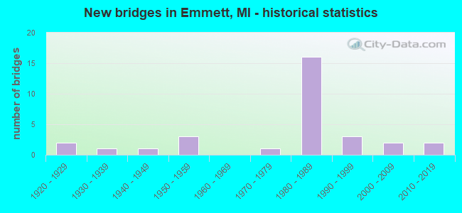
- New bridges - historical statistics
- 21920-1929
- 11930-1939
- 11940-1949
- 31950-1959
- 11970-1979
- 161980-1989
- 31990-1999
- 22000-2009
- 22010-2019

- Reconstructed bridges - Historical Statistics
- 21970-1979
- 01980-1989
- 21990-1999
- 12000-2009


- Bridge Condition - Deck
- 37.5%Good
- 56.3%Satisfactory
- 6.3%Fair

- Bridge Condition - Superstructure
- 18.8%Very good
- 43.8%Good
- 31.3%Satisfactory
- 6.3%Poor

- Bridge Condition - Substructure
- 6.3%Very good
- 37.5%Good
- 31.3%Satisfactory
- 25.0%Fair

- Bridge Condition - Channel
- 5.3%Very good
- 21.1%Good
- 42.1%Satisfactory
- 31.6%Fair

- Bridge Condition - Culverts
- 33.3%Very good
- 22.2%Good
- 22.2%Satisfactory
- 22.2%Poor
Find on map >> Show street view
Structure Number: 9897, Location: 1.8 MI S OF I-69 (Lat: 42.966514, Lng: -82.763750), Route carried "on" structure: State highway 19, Year Built: 2007, Status: Open, Structure Length: 0.78m (2.56ft), Average Daily Traffic: 6,607 (year 2007), Truck Traffic: 7%, Average Future Daily Traffic: 9,400 (year 2028), Design Load: HS 25 or greater, Features Intersected: COWHEY CREEK
Minimum Vertical Clearance: 30.48m (100.00ft), Kilometerpoint: 6.127, Lanes on structure: 2, Base Highway Network: Yes (Inventory Route: 96, Subroute: 5), Owner: State Highway Agency, Approaching Roadway Width: 13.4m (44.0ft), Material/Design: Concrete, Design/Construction: Culvert, Number Of Spans In Main Unit: 1, Length of Maximum Span: 7.3m (24.0ft), Curb-To-Curb Width: 13.4m (44.0ft), Out-to-Out Width: 14.9m (48.9ft)
Condition: Channel: Satisfactory, Culverts: Very good, Operating Rating: 67.6 metric tons, Method Used To Determine Operating Rating: Field evaluation and documented engineering judgment, Inventory Rating: 40.5 metric tons, Method Used To Determine Inventory Rating: Field evaluation and documented engineering judgment, Structural Evaluation: Equal to present desirable criteria, Deck Geometry: Equal to present minimum criteria, Waterway Adequacy: Equal to present desirable criteria, Approach Roadway Alignment: Equal to present desirable criteria, Designated Inspection Frequency: Every 24 months, Inspection Date: October 2020, Deck Structure Type: Concrete Cast-file-Place, Wearing Surface/Protective System: Wearing Surface: Integral Concrete, Deck Protection: Epoxy Coated Reinforcing
Find on map >> Show street view
Structure Number: 99, Location: 0.5 MI N OF M-21 (Lat: 43.003381, Lng: -82.760997), Route carried "on" structure: State highway 19, Year Built: 1987, Status: Open, Structure Length: 0.81m (2.66ft), Average Daily Traffic: 4,690 (year 2007), Truck Traffic: 10%, Average Future Daily Traffic: 8,954 (year 2018), Design Load: HS 20, Features Intersected: EMMETT DRAIN
Minimum Vertical Clearance: 30.48m (100.00ft), Kilometerpoint: 10.292, Lanes on structure: 2, Base Highway Network: Yes (Inventory Route: 96, Subroute: 5), Owner: State Highway Agency, Approaching Roadway Width: 13.4m (44.0ft), Skew: 1 degrees, Material/Design: Prestressed concrete, Design/Construction: Stringer/Multi-beam, Number Of Spans In Main Unit: 1, Length of Maximum Span: 7.3m (24.0ft), Curb-To-Curb Width: 14.6m (47.9ft), Out-to-Out Width: 15.6m (51.2ft)
Condition: Deck: Good, Superstructure: Very good, Substructure: Good, Channel: Good, Operating Rating: 69.0 metric tons, Method Used To Determine Operating Rating: Load Factor (LF) rating reported by rating factor (RF) method using MS18 loading, Inventory Rating: 41.1 metric tons, Method Used To Determine Inventory Rating: Load Factor (LF) rating reported by rating factor (RF) method using MS18 loading, Structural Evaluation: Better than present minimum criteria, Deck Geometry: Superior to present desirable criteria, Waterway Adequacy: Equal to present desirable criteria, Approach Roadway Alignment: Better than present minimum criteria, Designated Inspection Frequency: Every 24 months, Inspection Date: November 2021, Deck Structure Type: Concrete Cast-file-Place, Wearing Surface/Protective System: Wearing Surface: Epoxy Overlay, Deck Protection: Epoxy Coated Reinforcing
Find on map >> Show street view
Structure Number: 9918, Location: 1.3 MI E OF M-19 (Lat: 42.994333, Lng: -82.739167), Route carried "on" structure: County highway , Year Built: 1953, Year Reconstructed: 2002, Status: Open, Structure Length: 1.06m (3.48ft), Average Daily Traffic: 2,987 (year 2020), Truck Traffic: 5%, Average Future Daily Traffic: 4,435 (year 2040), Design Load: HS 20, Features Intersected: COWHEY CR, Facility Carried by Structure: LAPEER RD (M-21)
Minimum Vertical Clearance: 30.48m (100.00ft), Kilometerpoint: 5.462, Lanes on structure: 2, Owner: County Highway Agency, Approaching Roadway Width: 13.4m (44.0ft), Material/Design: Prestressed concrete, Design/Construction: Box Beam or Girders - Single/Spread, Number Of Spans In Main Unit: 1, Length of Maximum Span: 9.7m (31.8ft), Curb-To-Curb Width: 13.2m (43.3ft), Out-to-Out Width: 14.1m (46.3ft)
Condition: Deck: Good, Superstructure: Very good, Substructure: Satisfactory, Channel: Satisfactory, Operating Rating: 97.2 metric tons, Method Used To Determine Operating Rating: Load Factor (LF) rating reported by rating factor (RF) method using MS18 loading, Inventory Rating: 58.3 metric tons, Method Used To Determine Inventory Rating: Load Factor (LF) rating reported by rating factor (RF) method using MS18 loading, Structural Evaluation: Equal to present minimum criteria, Deck Geometry: Equal to present minimum criteria, Waterway Adequacy: Equal to present desirable criteria, Approach Roadway Alignment: Better than present minimum criteria, Designated Inspection Frequency: Every 24 months, Inspection Date: March 2021, Deck Structure Type: Concrete Cast-file-Place, Wearing Surface/Protective System: Wearing Surface: Monolithic Concrete, Deck Protection: Epoxy Coated Reinforcing
Find on map >> Show street view
Structure Number: 9919, Location: 1.5 MI E OF M-19 (Lat: 42.994450, Lng: -82.735669), Route carried "on" structure: ServiceCounty highway , Year Built: 1953, Year Reconstructed: 2002, Status: Open, Structure Length: 1.25m (4.10ft), Average Daily Traffic: 2,987 (year 2020), Truck Traffic: 5%, Average Future Daily Traffic: 4,435 (year 2040), Design Load: HS 20, Features Intersected: COWHEY CR, Facility Carried by Structure: LAPEER RD (M-21)
Minimum Vertical Clearance: 30.48m (100.00ft), Kilometerpoint: 5.749, Lanes on structure: 2, Owner: County Highway Agency, Approaching Roadway Width: 12.8m (42.0ft), Skew: 3 degrees, Material/Design: Prestressed concrete, Design/Construction: Box Beam or Girders - Single/Spread, Number Of Spans In Main Unit: 1, Length of Maximum Span: 11.3m (37.1ft), Curb-To-Curb Width: 13.2m (43.3ft), Out-to-Out Width: 14.1m (46.3ft)
Condition: Deck: Good, Superstructure: Very good, Substructure: Satisfactory, Channel: Good, Operating Rating: 88.8 metric tons, Method Used To Determine Operating Rating: Load Factor (LF) rating reported by rating factor (RF) method using MS18 loading, Inventory Rating: 53.1 metric tons, Method Used To Determine Inventory Rating: Load Factor (LF) rating reported by rating factor (RF) method using MS18 loading, Structural Evaluation: Equal to present minimum criteria, Deck Geometry: Equal to present minimum criteria, Waterway Adequacy: Equal to present desirable criteria, Approach Roadway Alignment: Better than present minimum criteria, Designated Inspection Frequency: Every 24 months, Inspection Date: March 2021, Deck Structure Type: Concrete Cast-file-Place, Wearing Surface/Protective System: Wearing Surface: Monolithic Concrete, Deck Protection: Epoxy Coated Reinforcing
Find on map >> Show street view
Structure Number: 994, Location: 2.5 MI SE OF EMMETT (Lat: 42.975139, Lng: -82.744592), Route carried "on" structure: County highway , Year Built: 1981, Status: Open, Structure Length: 9.81m (32.19ft), Average Daily Traffic: 200 (year 1995), Truck Traffic: 2%, Average Future Daily Traffic: 230 (year 2015), Design Load: H 20, Features Intersected: I-69, Facility Carried by Structure: STAPLETON RD
Minimum Vertical Clearance: 30.48m (100.00ft), Kilometerpoint: 3.669, Lanes on structure: 2, Lanes under structure: 4, Owner: State Highway Agency, Approaching Roadway Width: 11.5m (37.7ft), Skew: 3 degrees, Material/Design: Steel, Design/Construction: Stringer/Multi-beam, Number Of Spans In Main Unit: 2, Length of Maximum Span: 48.1m (157.8ft), Curb-To-Curb Width: 11.0m (36.1ft), Out-to-Out Width: 12.2m (40.0ft)
Condition: Deck: Satisfactory, Superstructure: Good, Substructure: Satisfactory, Operating Rating: 78.1 metric tons, Method Used To Determine Operating Rating: Load Factor (LF) rating reported by rating factor (RF) method using MS18 loading, Inventory Rating: 47.0 metric tons, Method Used To Determine Inventory Rating: Load Factor (LF) rating reported by rating factor (RF) method using MS18 loading, Structural Evaluation: Equal to present minimum criteria, Deck Geometry: Equal to present desirable criteria, Underclear: Somewhat better than minimum adequacy, Approach Roadway Alignment: Equal to present desirable criteria, Designated Inspection Frequency: Every 24 months, Inspection Date: November 2021, Deck Structure Type: Concrete Cast-file-Place, Wearing Surface/Protective System: Wearing Surface: Epoxy Overlay, Deck Protection: Epoxy Coated Reinforcing
Find on map >> Show street view
Structure Number: 9941, Location: 3.5 MI SE OF EMMETT (Lat: 42.971769, Lng: -82.725181), Route carried "on" structure: County highway , Year Built: 1981, Year Reconstructed: 2011, Status: Open, Structure Length: 7.99m (26.21ft), Average Daily Traffic: 150 (year 1995), Truck Traffic: 2%, Average Future Daily Traffic: 173 (year 2015), Design Load: HS 20, Features Intersected: I-69, Facility Carried by Structure: FOX ROAD
Minimum Vertical Clearance: 30.48m (100.00ft), Kilometerpoint: 4.513, Lanes on structure: 2, Lanes under structure: 4, Owner: State Highway Agency, Approaching Roadway Width: 10.9m (35.8ft), Material/Design: Steel continuous, Design/Construction: Box Beam or Girders - Multiple, Number Of Spans In Main Unit: 2, Length of Maximum Span: 39.3m (128.9ft), Curb-To-Curb Width: 11.0m (36.1ft), Out-to-Out Width: 12.2m (40.0ft)
Condition: Deck: Good, Superstructure: Good, Substructure: Good, Operating Rating: 91.7 metric tons, Method Used To Determine Operating Rating: Load Factor (LF) rating reported by rating factor (RF) method using MS18 loading, Inventory Rating: 54.8 metric tons, Method Used To Determine Inventory Rating: Load Factor (LF) rating reported by rating factor (RF) method using MS18 loading, Structural Evaluation: Better than present minimum criteria, Deck Geometry: Equal to present desirable criteria, Underclear: Equal to present minimum criteria, Approach Roadway Alignment: Equal to present desirable criteria, Designated Inspection Frequency: Every 24 months, Inspection Date: November 2021, Deck Structure Type: Concrete Cast-file-Place, Wearing Surface/Protective System: Wearing Surface: Epoxy Overlay, Deck Protection: Epoxy Coated Reinforcing
Find on map >> Show street view
Structure Number: 9952, Location: 4 MI W OF EMMETT (Lat: 42.976783, Lng: -82.823222), Route carried "on" structure: County highway , Year Built: 1982, Status: Open, Structure Length: 10.06m (33.01ft), Average Daily Traffic: 100 (year 1995), Truck Traffic: 2%, Average Future Daily Traffic: 115 (year 2005), Design Load: HS 20, Features Intersected: I-69, Facility Carried by Structure: EAGLING RD
Minimum Vertical Clearance: 30.48m (100.00ft), Kilometerpoint: 4.065, Lanes on structure: 2, Lanes under structure: 4, Owner: State Highway Agency, Approaching Roadway Width: 12.8m (42.0ft), Material/Design: Steel continuous, Design/Construction: Stringer/Multi-beam, Number Of Spans In Main Unit: 3, Length of Maximum Span: 39.3m (128.9ft), Curb-To-Curb Width: 11.0m (36.1ft), Out-to-Out Width: 12.2m (40.0ft)
Condition: Deck: Satisfactory, Superstructure: Good, Substructure: Satisfactory, Operating Rating: 69.0 metric tons, Method Used To Determine Operating Rating: Load Factor (LF) rating reported by rating factor (RF) method using MS18 loading, Inventory Rating: 41.5 metric tons, Method Used To Determine Inventory Rating: Load Factor (LF) rating reported by rating factor (RF) method using MS18 loading, Structural Evaluation: Equal to present minimum criteria, Deck Geometry: Superior to present desirable criteria, Underclear: Better than present minimum criteria, Approach Roadway Alignment: Equal to present desirable criteria, Designated Inspection Frequency: Every 24 months, Inspection Date: November 2021, Deck Structure Type: Concrete Cast-file-Place, Wearing Surface/Protective System: Wearing Surface: Monolithic Concrete, Deck Protection: Epoxy Coated Reinforcing
Find on map >> Show street view
Structure Number: 9953, Location: 3 MI W OF EMMETT (Lat: 42.977994, Lng: -82.803369), Route carried "on" structure: County highway , Year Built: 1982, Status: Open, Structure Length: 10.42m (34.19ft), Average Daily Traffic: 164 (year 1981), Truck Traffic: 2%, Average Future Daily Traffic: 189 (year 2001), Design Load: HS 20, Features Intersected: I-69, Facility Carried by Structure: BRAIDWOOD ROAD
Minimum Vertical Clearance: 30.48m (100.00ft), Kilometerpoint: 9.143, Lanes on structure: 2, Lanes under structure: 4, Owner: State Highway Agency, Approaching Roadway Width: 10.9m (35.8ft), Material/Design: Steel continuous, Design/Construction: Stringer/Multi-beam, Number Of Spans In Main Unit: 3, Length of Maximum Span: 37.4m (122.7ft), Curb-To-Curb Width: 11.0m (36.1ft), Out-to-Out Width: 12.2m (40.0ft)
Condition: Deck: Satisfactory, Superstructure: Good, Substructure: Good, Operating Rating: 72.6 metric tons, Method Used To Determine Operating Rating: Load Factor (LF) rating reported by rating factor (RF) method using MS18 loading, Inventory Rating: 43.4 metric tons, Method Used To Determine Inventory Rating: Load Factor (LF) rating reported by rating factor (RF) method using MS18 loading, Structural Evaluation: Better than present minimum criteria, Deck Geometry: Equal to present desirable criteria, Underclear: Equal to present minimum criteria, Approach Roadway Alignment: Equal to present desirable criteria, Designated Inspection Frequency: Every 24 months, Inspection Date: November 2021, Deck Structure Type: Concrete Cast-file-Place, Wearing Surface/Protective System: Wearing Surface: Epoxy Overlay, Deck Protection: Epoxy Coated Reinforcing
Find on map >> Show street view
Structure Number: 9954, Location: 2 MI W OF EMMETT (Lat: 42.978431, Lng: -82.784697), Route carried "on" structure: County highway , Year Built: 1982, Status: Open, Structure Length: 8.20m (26.90ft), Average Daily Traffic: 640 (year 1981), Truck Traffic: 2%, Average Future Daily Traffic: 736 (year 2001), Design Load: HS 20, Features Intersected: I-69, Facility Carried by Structure: REEVES RD
Minimum Vertical Clearance: 30.48m (100.00ft), Kilometerpoint: 2.561, Lanes on structure: 2, Lanes under structure: 4, Owner: State Highway Agency, Approaching Roadway Width: 11.5m (37.7ft), Material/Design: Steel continuous, Design/Construction: Stringer/Multi-beam, Number Of Spans In Main Unit: 2, Length of Maximum Span: 41.1m (134.8ft), Curb-To-Curb Width: 11.0m (36.1ft), Out-to-Out Width: 12.2m (40.0ft)
Condition: Deck: Satisfactory, Superstructure: Good, Substructure: Good, Operating Rating: 71.3 metric tons, Method Used To Determine Operating Rating: Load Factor (LF) rating reported by rating factor (RF) method using MS18 loading, Inventory Rating: 42.8 metric tons, Method Used To Determine Inventory Rating: Load Factor (LF) rating reported by rating factor (RF) method using MS18 loading, Structural Evaluation: Better than present minimum criteria, Deck Geometry: Better than present minimum criteria, Underclear: Somewhat better than minimum adequacy, Approach Roadway Alignment: Equal to present desirable criteria, Designated Inspection Frequency: Every 24 months, Inspection Date: November 2021, Deck Structure Type: Concrete Cast-file-Place, Wearing Surface/Protective System: Wearing Surface: Epoxy Overlay, Deck Protection: Epoxy Coated Reinforcing
Find on map >> Show street view
Structure Number: 9955, Location: 1 MI S OF EMMETT (Lat: 42.979917, Lng: -82.764633), Route carried "on" structure: State highway 19, Year Built: 1981, Status: Open, Structure Length: 8.05m (26.41ft), Average Daily Traffic: 6,607 (year 2007), Truck Traffic: 6%, Average Future Daily Traffic: 9,800 (year 2018), Design Load: HS 25 or greater, Features Intersected: I-69
Minimum Vertical Clearance: 30.48m (100.00ft), Kilometerpoint: 7.617, Lanes on structure: 4, Lanes under structure: 4, Base Highway Network: Yes (Inventory Route: 96, Subroute: 5), Owner: State Highway Agency, Approaching Roadway Width: 14.6m (47.9ft), Material/Design: Steel continuous, Design/Construction: Stringer/Multi-beam, Number Of Spans In Main Unit: 2, Length of Maximum Span: 39.6m (129.9ft), Curb-To-Curb Width: 14.6m (47.9ft), Out-to-Out Width: 15.8m (51.8ft)
Condition: Deck: Satisfactory, Superstructure: Satisfactory, Substructure: Fair, Operating Rating: 54.8 metric tons, Method Used To Determine Operating Rating: Load and Resistance Factor Rating (LRFR) rating reported by rating factor(RF) method using HL-93 loadings, Inventory Rating: 42.4 metric tons, Method Used To Determine Inventory Rating: Load and Resistance Factor Rating (LRFR) rating reported by rating factor(RF) method using HL-93 loadings, Structural Evaluation: Somewhat better than minimum adequacy, Deck Geometry: High priority of replacement, Underclear: Better than present minimum criteria, Approach Roadway Alignment: Equal to present desirable criteria, Designated Inspection Frequency: Every 24 months, Inspection Date: November 2021, Deck Structure Type: Concrete Cast-file-Place, Wearing Surface/Protective System: Wearing Surface: Monolithic Concrete, Deck Protection: Epoxy Coated Reinforcing
Find on map >> Show street view
Structure Number: 10088, Location: SEC. 17 WALES TWP. (Lat: 42.946714, Lng: -82.708836), Route carried "on" structure: County highway , Year Built: 1921, Status: Open, Structure Length: 0.80m (2.62ft), Average Daily Traffic: 188 (year 2001), Truck Traffic: 3%, Average Future Daily Traffic: 340 (year 0221), Design Load: H 20, Features Intersected: UNNAMED CREEK, Facility Carried by Structure: COVE ROAD
Minimum Vertical Clearance: 30.48m (100.00ft), Kilometerpoint: 3.655, Lanes on structure: 2, Owner: County Highway Agency, Approaching Roadway Width: 7.3m (24.0ft), Material/Design: Concrete, Design/Construction: Tee Beam, Number Of Spans In Main Unit: 1, Length of Maximum Span: 6.7m (22.0ft), Curb-To-Curb Width: 5.9m (19.4ft), Out-to-Out Width: 6.7m (22.0ft)
Condition: Deck: Satisfactory, Superstructure: Poor, Substructure: Satisfactory, Channel: Fair, Operating Rating: 57.0 metric tons, Method Used To Determine Operating Rating: Load Factor (LF) rating reported by rating factor (RF) method using MS18 loading, Inventory Rating: 34.0 metric tons, Method Used To Determine Inventory Rating: Load Factor (LF) rating reported by rating factor (RF) method using MS18 loading, Structural Evaluation: Meets minimum limits, Deck Geometry: High priority of corrective action, Waterway Adequacy: Somewhat better than minimum adequacy, Approach Roadway Alignment: Equal to present desirable criteria, Designated Inspection Frequency: Every 12 months, Inspection Date: January 2022, Deck Structure Type: Concrete Cast-file-Place, Wearing Surface/Protective System: Wearing Surface: Monolithic Concrete
Find on map >> Show street view
Structure Number: 10161, Location: SEC. 13-24 EMMETT TWP. (Lat: 43.029728, Lng: -82.767314), Route carried "on" structure: ServiceCounty highway , Year Built: 1994, Status: Open, Structure Length: 0.67m (2.20ft), Average Daily Traffic: 130 (year 1994), Average Future Daily Traffic: 220 (year 2014), Design Load: HS 20, Features Intersected: WHACKENBUSH DRAIN, Facility Carried by Structure: IMLAY CITY ROAD
Minimum Vertical Clearance: 30.48m (100.00ft), Kilometerpoint: 18.051, Lanes on structure: 2, Owner: County Highway Agency, Approaching Roadway Width: 9.1m (29.9ft), Skew: 3 degrees, Material/Design: Concrete, Design/Construction: Culvert, Number Of Spans In Main Unit: 1, Length of Maximum Span: 6.1m (20.0ft), Curb-To-Curb Width: 8.2m (26.9ft), Out-to-Out Width: 9.1m (29.9ft)
Condition: Channel: Good, Culverts: Good, Operating Rating: 44.1 metric tons, Method Used To Determine Operating Rating: Load Factor (LF) rating reported by rating factor (RF) method using MS18 loading, Inventory Rating: 26.2 metric tons, Method Used To Determine Inventory Rating: Load Factor (LF) rating reported by rating factor (RF) method using MS18 loading, Structural Evaluation: Equal to present minimum criteria, Deck Geometry: Somewhat better than minimum adequacy, Waterway Adequacy: Equal to present desirable criteria, Approach Roadway Alignment: Equal to present desirable criteria, Designated Inspection Frequency: Every 24 months, Inspection Date: November 2020, Wearing Surface/Protective System: Wearing Surface: Bituminous, Membrane: Other
Find on map >> Show street view
Structure Number: 10192, Location: SEC 19-30 KENOCKEE TWP (Lat: 43.016317, Lng: -82.733128), Route carried "on" structure: ServiceCounty highway , Year Built: 1981, Status: Open, Structure Length: 0.64m (2.10ft), Average Daily Traffic: 135 (year 1994), Truck Traffic: 3%, Average Future Daily Traffic: 155 (year 2014), Design Load: HS 20+Mod, Features Intersected: EMMETT DRAIN, Facility Carried by Structure: BRYCE ROAD
Minimum Vertical Clearance: 30.48m (100.00ft), Kilometerpoint: 19.208, Lanes on structure: 2, Owner: County Highway Agency, Approaching Roadway Width: 6.1m (20.0ft), Material/Design: Steel, Design/Construction: Culvert, Number Of Spans In Main Unit: 2, Length of Maximum Span: 2.7m (8.9ft)
Condition: Channel: Satisfactory, Culverts: Poor, Operating Rating: 42.4 metric tons, Method Used To Determine Operating Rating: Load and Resistance Factor Rating (LRFR) rating reported by rating factor(RF) method using HL-93 loadings, Inventory Rating: 32.7 metric tons, Method Used To Determine Inventory Rating: Load and Resistance Factor Rating (LRFR) rating reported by rating factor(RF) method using HL-93 loadings, Structural Evaluation: Meets minimum limits, Waterway Adequacy: Equal to present desirable criteria, Approach Roadway Alignment: Better than present minimum criteria, Designated Inspection Frequency: Every 12 months, Inspection Date: March 2021, Roadway Improvement Cost: $7,000, Total Project Cost: $8,000, Wearing Surface/Protective System: Wearing Surface: Gravel
Find on map >> Show street view
Structure Number: 10195, Location: SEC 19 KENOCKEE TWP (Lat: 43.023083, Lng: -82.749653), Route carried "on" structure: ServiceCounty highway , Year Built: 1971, Status: Open, Structure Length: 0.88m (2.89ft), Average Daily Traffic: 51 (year 1994), Average Future Daily Traffic: 60 (year 2014), Design Load: HS 20+Mod, Features Intersected: SULLIVAN DRAIN, Facility Carried by Structure: BRENNAN ROAD
Minimum Vertical Clearance: 30.48m (100.00ft), Kilometerpoint: 1.376, Lanes on structure: 2, Owner: County Highway Agency, Approaching Roadway Width: 6.1m (20.0ft), Material/Design: Prestressed concrete, Design/Construction: Tee Beam, Number Of Spans In Main Unit: 1, Length of Maximum Span: 7.3m (24.0ft), Curb-To-Curb Width: 9.1m (29.9ft), Out-to-Out Width: 9.8m (32.2ft)
Condition: Deck: Satisfactory, Superstructure: Satisfactory, Substructure: Good, Channel: Satisfactory, Operating Rating: 69.0 metric tons, Method Used To Determine Operating Rating: Load Factor (LF) rating reported by rating factor (RF) method using MS18 loading, Inventory Rating: 41.1 metric tons, Method Used To Determine Inventory Rating: Load Factor (LF) rating reported by rating factor (RF) method using MS18 loading, Structural Evaluation: Equal to present minimum criteria, Deck Geometry: Better than present minimum criteria, Waterway Adequacy: Meets minimum limits, Approach Roadway Alignment: Better than present minimum criteria, Length Of Structure Improvement: 2.29m (7.51ft), Designated Inspection Frequency: Every 24 months, Inspection Date: April 2021, Roadway Improvement Cost: $12,000, Total Project Cost: $14,000, Deck Structure Type: Concrete Cast-file-Place, Wearing Surface/Protective System: Wearing Surface: Bituminous
Find on map >> Show street view
Structure Number: 10196, Location: SEC. 31 KENOCKEE TWP. (Lat: 42.991636, Lng: -82.745550), Route carried "on" structure: ServiceCounty highway , Year Built: 2013, Status: Open, Structure Length: 0.75m (2.46ft), Average Daily Traffic: 174 (year 2009), Average Future Daily Traffic: 198 (year 2019), Design Load: HS 20+Mod, Features Intersected: UNNAMED CREEK, Facility Carried by Structure: STAPLETON ROAD
Minimum Vertical Clearance: 30.48m (100.00ft), Kilometerpoint: 5.504, Lanes on structure: 2, Owner: County Highway Agency, Approaching Roadway Width: 6.1m (20.0ft), Skew: 6 degrees, Material/Design: Steel, Design/Construction: Culvert, Number Of Spans In Main Unit: 2, Length of Maximum Span: 3.5m (11.5ft)
Condition: Channel: Very good, Culverts: Very good, Operating Rating: 23.3 metric tons, Method Used To Determine Operating Rating: Load and Resistance Factor Rating (LRFR) rating reported by rating factor(RF) method using HL-93 loadings, Inventory Rating: 18.1 metric tons, Method Used To Determine Inventory Rating: Load and Resistance Factor Rating (LRFR) rating reported by rating factor(RF) method using HL-93 loadings, Structural Evaluation: Somewhat better than minimum adequacy, Waterway Adequacy: Better than present minimum criteria, Approach Roadway Alignment: Equal to present desirable criteria, Designated Inspection Frequency: Every 24 months, Inspection Date: August 2021, Wearing Surface/Protective System: Wearing Surface: Gravel
Find on map >> Show street view
Structure Number: 10197, Location: SEC. 30 KENOCKEE TWP (Lat: 43.006286, Lng: -82.741564), Route carried "on" structure: ServiceCounty highway , Year Built: 1958, Status: Open, Structure Length: 0.64m (2.10ft), Average Daily Traffic: 59 (year 1994), Average Future Daily Traffic: 102 (year 2014), Design Load: HS 20, Features Intersected: EMMETT DRAIN, Facility Carried by Structure: COGLEY ROAD
Minimum Vertical Clearance: 30.48m (100.00ft), Kilometerpoint: 1.336, Lanes on structure: 2, Owner: County Highway Agency, Approaching Roadway Width: 5.4m (17.7ft), Material/Design: Steel, Design/Construction: Culvert, Number Of Spans In Main Unit: 2, Length of Maximum Span: 3.0m (9.8ft)
Condition: Channel: Fair, Culverts: Poor, Operating Rating: 45.7 metric tons, Method Used To Determine Operating Rating: Load and Resistance Factor Rating (LRFR) rating reported by rating factor(RF) method using HL-93 loadings, Inventory Rating: 36.6 metric tons, Method Used To Determine Inventory Rating: Load and Resistance Factor Rating (LRFR) rating reported by rating factor(RF) method using HL-93 loadings, Structural Evaluation: Meets minimum limits, Waterway Adequacy: Better than present minimum criteria, Approach Roadway Alignment: Equal to present desirable criteria, Length Of Structure Improvement: 2.29m (7.51ft), Designated Inspection Frequency: Every 24 months, Inspection Date: March 2021, Roadway Improvement Cost: $15,000, Total Project Cost: $16,000, Wearing Surface/Protective System: Wearing Surface: Gravel
Find on map >> Show street view
Structure Number: 10199, Location: SEC. 7-8 KENOCKEE TWP. (Lat: 43.054350, Lng: -82.734725), Route carried "on" structure: ServiceCounty highway , Year Built: 1940, Status: Posted for load, Structure Length: 1.86m (6.10ft), Average Daily Traffic: 179 (year 2021), Truck Traffic: 5%, Average Future Daily Traffic: 266 (year 2041), Design Load: H 20, Features Intersected: MILL CREEK, Facility Carried by Structure: BRICKER ROAD
Minimum Vertical Clearance: 30.48m (100.00ft), Kilometerpoint: 8.309, Lanes on structure: 2, Owner: County Highway Agency, Approaching Roadway Width: 7.3m (24.0ft), Material/Design: Steel, Design/Construction: Stringer/Multi-beam, Number Of Spans In Main Unit: 1, Length of Maximum Span: 17.3m (56.8ft), Curb-To-Curb Width: 7.3m (24.0ft), Out-to-Out Width: 8.8m (28.9ft)
Condition: Deck: Satisfactory, Superstructure: Satisfactory, Substructure: Fair, Channel: Fair, Operating Rating: 43.4 metric tons, Method Used To Determine Operating Rating: Load Factor (LF) rating reported by rating factor (RF) method using MS18 loading, Inventory Rating: 25.9 metric tons, Method Used To Determine Inventory Rating: Load Factor (LF) rating reported by rating factor (RF) method using MS18 loading, Structural Evaluation: Somewhat better than minimum adequacy, Deck Geometry: Somewhat better than minimum adequacy, Waterway Adequacy: Equal to present minimum criteria, Approach Roadway Alignment: Equal to present minimum criteria, Bridge Posting: Required (Relationship of Operating Rating to Maximum Legal Load: 20.0 - 29.9% below), Designated Inspection Frequency: Every 24 months, Inspection Date: June 2021, Deck Structure Type: Concrete Cast-file-Place, Wearing Surface/Protective System: Wearing Surface: Monolithic Concrete
Find on map >> Show street view
Structure Number: 102, Location: SEC. 20-21 KENOCKEE TWP. (Lat: 43.024414, Lng: -82.712739), Route carried "on" structure: ServiceCounty highway , Year Built: 1993, Status: Open, Structure Length: 1.52m (4.99ft), Average Daily Traffic: 91 (year 1994), Average Future Daily Traffic: 111 (year 2014), Design Load: HS 20+Mod, Features Intersected: PINE RIVER, Facility Carried by Structure: BROWN ROAD
Minimum Vertical Clearance: 30.48m (100.00ft), Kilometerpoint: 0.808, Lanes on structure: 2, Owner: County Highway Agency, Approaching Roadway Width: 9.1m (29.9ft), Skew: 1 degrees, Material/Design: Prestressed concrete, Design/Construction: Tee Beam, Number Of Spans In Main Unit: 2, Length of Maximum Span: 7.3m (24.0ft), Curb-To-Curb Width: 9.1m (29.9ft), Out-to-Out Width: 9.8m (32.2ft)
Condition: Deck: Good, Superstructure: Good, Substructure: Good, Channel: Satisfactory, Operating Rating: 74.5 metric tons, Method Used To Determine Operating Rating: Load Factor (LF) rating reported by rating factor (RF) method using MS18 loading, Inventory Rating: 44.4 metric tons, Method Used To Determine Inventory Rating: Load Factor (LF) rating reported by rating factor (RF) method using MS18 loading, Structural Evaluation: Better than present minimum criteria, Deck Geometry: Better than present minimum criteria, Waterway Adequacy: Equal to present minimum criteria, Approach Roadway Alignment: Equal to present minimum criteria, Designated Inspection Frequency: Every 24 months, Inspection Date: March 2021, Deck Structure Type: Concrete Precast Panels, Wearing Surface/Protective System: Wearing Surface: Bituminous, Membrane: Preformed Fabric
Find on map >> Show street view
Structure Number: 10201, Location: SEC 16-17 KENOCKEE TWP (Lat: 43.032378, Lng: -82.713225), Route carried "on" structure: ServiceCounty highway , Year Built: 1980, Status: Open, Structure Length: 0.64m (2.10ft), Average Daily Traffic: 135 (year 1994), Truck Traffic: 3%, Average Future Daily Traffic: 155 (year 2014), Design Load: HS 20, Features Intersected: WHACKENBUSH DRAIN, Facility Carried by Structure: BROWN ROAD
Minimum Vertical Clearance: 30.48m (100.00ft), Kilometerpoint: 1.693, Lanes on structure: 2, Owner: County Highway Agency, Approaching Roadway Width: 6.1m (20.0ft), Material/Design: Steel, Design/Construction: Culvert, Number Of Spans In Main Unit: 2, Length of Maximum Span: 3.0m (9.8ft)
Condition: Channel: Fair, Culverts: Satisfactory, Operating Rating: 42.8 metric tons, Method Used To Determine Operating Rating: Load and Resistance Factor Rating (LRFR) rating reported by rating factor(RF) method using HL-93 loadings, Inventory Rating: 35.6 metric tons, Method Used To Determine Inventory Rating: Load and Resistance Factor Rating (LRFR) rating reported by rating factor(RF) method using HL-93 loadings, Structural Evaluation: Equal to present minimum criteria, Waterway Adequacy: Equal to present minimum criteria, Approach Roadway Alignment: Equal to present desirable criteria, Length Of Structure Improvement: 2.29m (7.51ft), Designated Inspection Frequency: Every 24 months, Inspection Date: March 2021, Roadway Improvement Cost: $6,000, Total Project Cost: $7,000, Wearing Surface/Protective System: Wearing Surface: Gravel
Find on map >> Show street view
Structure Number: 10207, Location: SEC. 31-32 KENOCKEE TWP. (Lat: 42.991389, Lng: -82.730708), Route carried "on" structure: ServiceCounty highway , Year Built: 1991, Status: Open, Structure Length: 1.03m (3.38ft), Average Daily Traffic: 94 (year 1994), Average Future Daily Traffic: 152 (year 2014), Design Load: HS 20+Mod, Features Intersected: S. BR. PINE RIVER DRAIN, Facility Carried by Structure: BRICKER ROAD
Minimum Vertical Clearance: 30.48m (100.00ft), Kilometerpoint: 1.286, Lanes on structure: 2, Owner: County Highway Agency, Approaching Roadway Width: 6.1m (20.0ft), Material/Design: Prestressed concrete, Design/Construction: Tee Beam, Number Of Spans In Main Unit: 1, Length of Maximum Span: 9.4m (30.8ft), Curb-To-Curb Width: 8.9m (29.2ft), Out-to-Out Width: 9.8m (32.2ft)
Condition: Deck: Good, Superstructure: Good, Substructure: Very good, Channel: Satisfactory, Operating Rating: 78.4 metric tons, Method Used To Determine Operating Rating: Load Factor (LF) rating reported by rating factor (RF) method using MS18 loading, Inventory Rating: 47.0 metric tons, Method Used To Determine Inventory Rating: Load Factor (LF) rating reported by rating factor (RF) method using MS18 loading, Structural Evaluation: Better than present minimum criteria, Deck Geometry: Better than present minimum criteria, Waterway Adequacy: Better than present minimum criteria, Approach Roadway Alignment: Better than present minimum criteria, Designated Inspection Frequency: Every 24 months, Inspection Date: March 2021, Deck Structure Type: Concrete Precast Panels, Wearing Surface/Protective System: Wearing Surface: Bituminous
Find on map >> Show street view
Structure Number: 10236, Location: SEC. 4 WALES TWP. (Lat: 42.980975, Lng: -82.704258), Route carried "on" structure: ServiceCounty highway , Year Built: 1935, Year Reconstructed: 1981, Status: Posted for load, Structure Length: 1.07m (3.51ft), Average Daily Traffic: 137 (year 2009), Truck Traffic: 4%, Average Future Daily Traffic: 246 (year 2029), Design Load: HS 20+Mod, Features Intersected: SOUTH BR. PINE RIVER, Facility Carried by Structure: WEBB ROAD
Minimum Vertical Clearance: 30.48m (100.00ft), Kilometerpoint: 3.320, Lanes on structure: 2, Owner: County Highway Agency, Approaching Roadway Width: 5.5m (18.0ft), Skew: 1 degrees, Material/Design: Prestressed concrete, Design/Construction: Tee Beam, Number Of Spans In Main Unit: 1, Length of Maximum Span: 9.1m (29.9ft), Curb-To-Curb Width: 5.8m (19.0ft), Out-to-Out Width: 6.4m (21.0ft)
Condition: Deck: Satisfactory, Superstructure: Satisfactory, Substructure: Fair, Channel: Good, Operating Rating: 42.4 metric tons, Method Used To Determine Operating Rating: Load Factor (LF) rating reported by rating factor (RF) method using MS18 loading, Inventory Rating: 24.0 metric tons, Method Used To Determine Inventory Rating: Load Factor (LF) rating reported by rating factor (RF) method using MS18 loading, Structural Evaluation: Somewhat better than minimum adequacy, Deck Geometry: High priority of corrective action, Waterway Adequacy: Equal to present minimum criteria, Approach Roadway Alignment: Better than present minimum criteria, Bridge Posting: Required (Relationship of Operating Rating to Maximum Legal Load: 0.1 - 9.9% below), Designated Inspection Frequency: Every 24 months, Inspection Date: December 2021, Deck Structure Type: Concrete Precast Panels, Wearing Surface/Protective System: Wearing Surface: Bituminous
Find on map >> Show street view
Structure Number: 10237, Location: SEC. 4 WALES TWP. (Lat: 42.980061, Lng: -82.690511), Route carried "on" structure: ServiceCounty highway , Year Built: 1920, Year Reconstructed: 1981, Status: Open, Structure Length: 1.22m (4.00ft), Average Daily Traffic: 122 (year 2008), Truck Traffic: 3%, Average Future Daily Traffic: 219 (year 2028), Design Load: HS 20+Mod, Features Intersected: S. BR. PINE RIVER, Facility Carried by Structure: KILGORE ROAD
Minimum Vertical Clearance: 30.48m (100.00ft), Kilometerpoint: 0.143, Lanes on structure: 2, Owner: County Highway Agency, Approaching Roadway Width: 6.7m (22.0ft), Material/Design: Prestressed concrete, Design/Construction: Box Beam or Girders - Multiple, Number Of Spans In Main Unit: 1, Length of Maximum Span: 11.0m (36.1ft), Curb-To-Curb Width: 6.4m (21.0ft), Out-to-Out Width: 6.5m (21.3ft)
Condition: Deck: Fair, Superstructure: Satisfactory, Substructure: Fair, Channel: Fair, Operating Rating: 62.5 metric tons, Method Used To Determine Operating Rating: Load Factor (LF) rating reported by rating factor (RF) method using MS18 loading, Inventory Rating: 37.3 metric tons, Method Used To Determine Inventory Rating: Load Factor (LF) rating reported by rating factor (RF) method using MS18 loading, Structural Evaluation: Somewhat better than minimum adequacy, Deck Geometry: Meets minimum limits, Waterway Adequacy: Equal to present minimum criteria, Approach Roadway Alignment: Equal to present desirable criteria, Designated Inspection Frequency: Every 12 months, Inspection Date: December 2021, Deck Structure Type: Concrete Precast Panels, Wearing Surface/Protective System: Wearing Surface: Bituminous
Find on map >> Show street view
Structure Number: 1024, Location: SEC 5 WALES TWP (Lat: 42.981675, Lng: -82.715639), Route carried "on" structure: ServiceCounty highway , Year Built: 2005, Status: Open, Structure Length: 0.77m (2.53ft), Average Daily Traffic: 84 (year 2009), Truck Traffic: 3%, Average Future Daily Traffic: 152 (year 2029), Design Load: HS 20, Features Intersected: S BRANCH PINE RIVER, Facility Carried by Structure: ONEIL ROAD
Minimum Vertical Clearance: 30.48m (100.00ft), Kilometerpoint: 0.129, Lanes on structure: 2, Owner: County Highway Agency, Approaching Roadway Width: 6.1m (20.0ft), Material/Design: Aluminum, Iron, Design/Construction: Culvert, Number Of Spans In Main Unit: 1, Length of Maximum Span: 7.7m (25.3ft), Out-to-Out Width: 11.0m (36.1ft)
Condition: Channel: Satisfactory, Culverts: Very good, Operating Rating: 45.0 metric tons, Method Used To Determine Operating Rating: Load Factor (LF) rating reported by rating factor (RF) method using MS18 loading, Inventory Rating: 37.9 metric tons, Method Used To Determine Inventory Rating: Load Factor (LF) rating reported by rating factor (RF) method using MS18 loading, Structural Evaluation: Equal to present desirable criteria, Waterway Adequacy: Equal to present minimum criteria, Approach Roadway Alignment: Equal to present minimum criteria, Designated Inspection Frequency: Every 24 months, Inspection Date: December 2021, Wearing Surface/Protective System: Wearing Surface: Bituminous
Find on map >> Show street view
Structure Number: 13693, Location: 1.0 MI EAST OF M-19 (Lat: 42.976050, Lng: -82.746164), Route carried "on" structure: Interstate 69, Year Built: 2016, Status: Open, Structure Length: 0.62m (2.03ft), Average Daily Traffic: 13,250 (year 2015), Truck Traffic: 25%, Average Future Daily Traffic: 15,400 (year 2035), Design Load: HL 93, Features Intersected: RILEY-WALES DRAIN
Minimum Vertical Clearance: 30.48m (100.00ft), Kilometerpoint: 20.203, Lanes on structure: 4, Base Highway Network: Yes (Inventory Route: 96, Subroute: 6), Owner: State Highway Agency, Approaching Roadway Width: 26.5m (86.9ft), Skew: 3 degrees, Material/Design: Concrete, Design/Construction: Culvert, Number Of Spans In Main Unit: 1, Length of Maximum Span: 5.6m (18.4ft), Curb-To-Curb Width: 26.5m (86.9ft), Out-to-Out Width: 93.3m (306.1ft)
Condition: Channel: Fair, Culverts: Good, Operating Rating: 87.5 metric tons, Method Used To Determine Operating Rating: Load and Resistance Factor Rating (LRFR) rating reported by rating factor(RF) method using HL-93 loadings, Inventory Rating: 67.4 metric tons, Method Used To Determine Inventory Rating: Load and Resistance Factor Rating (LRFR) rating reported by rating factor(RF) method using HL-93 loadings, Structural Evaluation: Better than present minimum criteria, Deck Geometry: Superior to present desirable criteria, Waterway Adequacy: Equal to present desirable criteria, Approach Roadway Alignment: Equal to present desirable criteria, Designated Inspection Frequency: Every 24 months, Inspection Date: March 2021, Wearing Surface/Protective System: Wearing Surface: Integral Concrete
Find on map >> Show street view
Structure Number: 13696, Location: N END OF M-19/I-69 INTRCH (Lat: 42.983378, Lng: -82.764817), Route carried "on" structure: State highway 19, Year Built: 1981, Status: Open, Structure Length: 0.88m (2.89ft), Average Daily Traffic: 6,607 (year 2007), Truck Traffic: 6%, Average Future Daily Traffic: 9,800 (year 2018), Design Load: HS 20, Features Intersected: COWHY DRAIN
Minimum Vertical Clearance: 30.48m (100.00ft), Kilometerpoint: 8.005, Lanes on structure: 4, Base Highway Network: Yes (Inventory Route: 96, Subroute: 5), Owner: State Highway Agency, Approaching Roadway Width: 12.8m (42.0ft), Material/Design: Concrete, Design/Construction: Culvert, Number Of Spans In Main Unit: 2, Length of Maximum Span: 4.0m (13.1ft), Curb-To-Curb Width: 13.4m (44.0ft), Out-to-Out Width: 53.0m (173.9ft)
Condition: Channel: Satisfactory, Culverts: Satisfactory, Operating Rating: 93.6 metric tons, Method Used To Determine Operating Rating: Load Factor (LF) rating reported by rating factor (RF) method using MS18 loading, Inventory Rating: 56.1 metric tons, Method Used To Determine Inventory Rating: Load Factor (LF) rating reported by rating factor (RF) method using MS18 loading, Structural Evaluation: Equal to present minimum criteria, Deck Geometry: High priority of replacement, Waterway Adequacy: Equal to present desirable criteria, Approach Roadway Alignment: Equal to present desirable criteria, Designated Inspection Frequency: Every 24 months, Inspection Date: March 2021, Wearing Surface/Protective System: Wearing Surface: Integral Concrete, Membrane: Other
Find on map >> Show street view
Structure Number: 994, Location: 2.5 MI SE OF EMMETT (Lat: 42.975139, Lng: -82.744592), Route carried "under" structure: Interstate 69, Year Built: 1981, Structure Length: 0. m, Average Daily Traffic: 14,004 (year 2007), Truck Traffic: 22%, Features Intersected: I-69, Facility Carried by Structure: STAPLETON RD
Minimum Vertical Clearance: 5.51m (18.08ft), Kilometerpoint: 20.362, Lanes on structure: 2, Lanes under structure: 4, Material/Design: Steel, Design/Construction: Stringer/Multi-beam, Length of Maximum Span: 48.1m (157.8ft)
Find on map >> Show street view
Structure Number: 9941, Location: 3.5 MI SE OF EMMETT (Lat: 42.971769, Lng: -82.725181), Route carried "under" structure: Interstate 69, Year Built: 1981, Structure Length: 0. m, Average Daily Traffic: 19,000 (year 2009), Truck Traffic: 22%, Features Intersected: I-69, Facility Carried by Structure: FOX ROAD
Minimum Vertical Clearance: 5.51m (18.08ft), Kilometerpoint: 22.031, Lanes on structure: 2, Lanes under structure: 4, Material/Design: Steel continuous, Design/Construction: Box Beam or Girders - Multiple, Length of Maximum Span: 39.3m (128.9ft)
Find on map >> Show street view
Structure Number: 9952, Location: 4 MI W OF EMMETT (Lat: 42.976783, Lng: -82.823222), Route carried "under" structure: Interstate 69, Year Built: 1982, Structure Length: 0. m, Average Daily Traffic: 14,830 (year 2007), Truck Traffic: 22%, Features Intersected: I-69, Facility Carried by Structure: EAGLING RD
Minimum Vertical Clearance: 5.92m (19.42ft), Kilometerpoint: 13.801, Lanes on structure: 2, Lanes under structure: 4, Material/Design: Steel continuous, Design/Construction: Stringer/Multi-beam, Length of Maximum Span: 39.3m (128.9ft)
Find on map >> Show street view
Structure Number: 9953, Location: 3 MI W OF EMMETT (Lat: 42.977994, Lng: -82.803369), Route carried "under" structure: Interstate 69, Year Built: 1982, Structure Length: 0. m, Average Daily Traffic: 19,000 (year 2009), Truck Traffic: 22%, Features Intersected: I-69, Facility Carried by Structure: BRAIDWOOD ROAD
Minimum Vertical Clearance: 5.72m (18.77ft), Kilometerpoint: 15.426, Lanes on structure: 2, Lanes under structure: 4, Material/Design: Steel continuous, Design/Construction: Stringer/Multi-beam, Length of Maximum Span: 37.4m (122.7ft)
Find on map >> Show street view
Structure Number: 9954, Location: 2 MI W OF EMMETT (Lat: 42.978431, Lng: -82.784697), Route carried "under" structure: Interstate 69, Year Built: 1982, Structure Length: 0. m, Average Daily Traffic: 19,000 (year 2009), Truck Traffic: 22%, Features Intersected: I-69, Facility Carried by Structure: REEVES RD
Minimum Vertical Clearance: 5.46m (17.91ft), Kilometerpoint: 16.950, Lanes on structure: 2, Lanes under structure: 4, Material/Design: Steel continuous, Design/Construction: Stringer/Multi-beam, Length of Maximum Span: 41.1m (134.8ft)
Find on map >> Show street view
Structure Number: 9955, Location: 1 MI S OF EMMETT (Lat: 42.979917, Lng: -82.764633), Route carried "under" structure: Interstate 69, Year Built: 1981, Structure Length: 0. m, Average Daily Traffic: 14,830 (year 2007), Truck Traffic: 22%, Features Intersected: I-69, Facility Carried by Structure: M-19 (KINNEY ROAD)
Minimum Vertical Clearance: 5.54m (18.18ft), Kilometerpoint: 18.595, Lanes on structure: 4, Lanes under structure: 4, Material/Design: Steel continuous, Design/Construction: Stringer/Multi-beam, Length of Maximum Span: 39.6m (129.9ft)