Bridge Statistics for Escanaba, Michigan (MI)
Condition, Traffic, Stress, Structural Evaluation, Project Costs
- National Bridge Inventory (NBI) Statistics
- 13Number of bridges
- 82ft / 25.4mTotal length
- $249,000Total costs
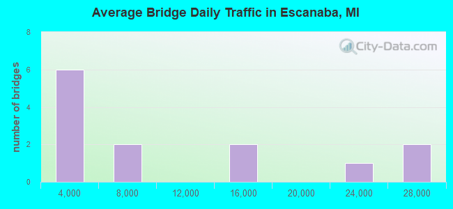
- 118,741Total average daily traffic
- 7,573Total average daily truck traffic
- National Bridge Inventory (NBI) Registered Bridges for Escanaba
- No street view available for this location
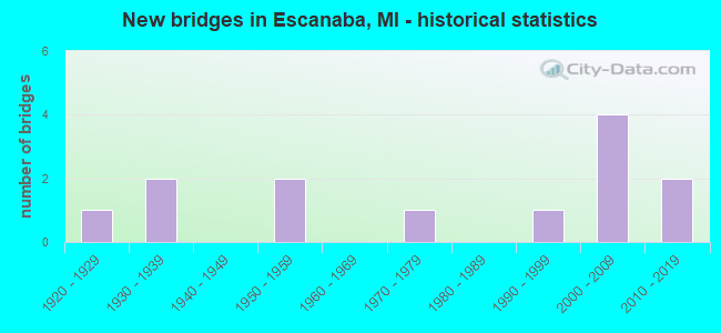
- New bridges - historical statistics
- 11920-1929
- 21930-1939
- 21950-1959
- 11970-1979
- 11990-1999
- 42000-2009
- 22010-2019
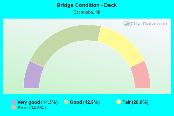
- Bridge Condition - Deck
- 14.3%Very good
- 42.9%Good
- 28.6%Fair
- 14.3%Poor
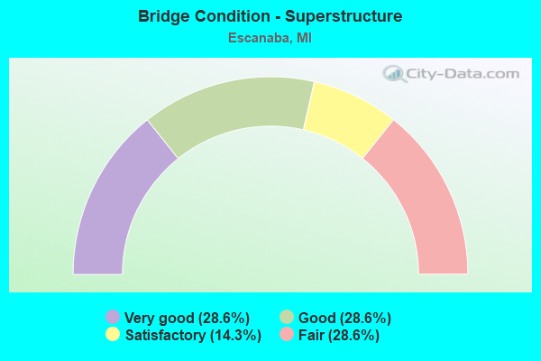
- Bridge Condition - Superstructure
- 28.6%Very good
- 28.6%Good
- 14.3%Satisfactory
- 28.6%Fair
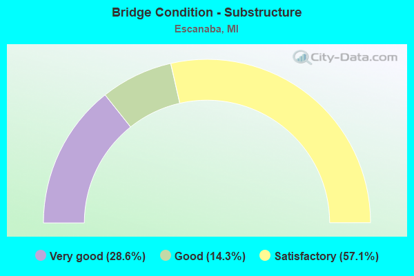
- Bridge Condition - Substructure
- 28.6%Very good
- 14.3%Good
- 57.1%Satisfactory
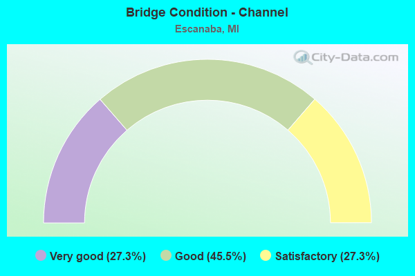
- Bridge Condition - Channel
- 27.3%Very good
- 45.5%Good
- 27.3%Satisfactory
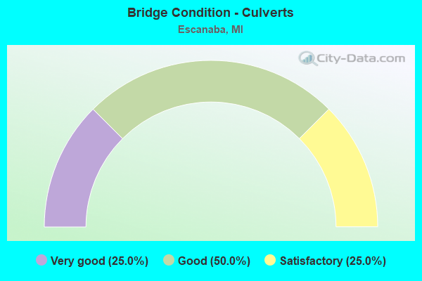
- Bridge Condition - Culverts
- 25.0%Very good
- 50.0%Good
- 25.0%Satisfactory
Find on map >> Show street view
Structure Number: 2082, Location: 3.4 MI W OF ESCANABA (Lat: 45.745764, Lng: -87.124500), Route carried "on" structure: US 2, Year Built: 1928, Year Reconstructed: 1985, Status: Open, Structure Length: 0.70m (2.30ft), Average Daily Traffic: 14,094 (year 2007), Truck Traffic: 4%, Average Future Daily Traffic: 21,372 (year 2018), Design Load: HS 20+Mod, Features Intersected: PORTAGE CREEK
Minimum Vertical Clearance: 30.48m (100.00ft), Kilometerpoint: 16.477, Lanes on structure: 2, Base Highway Network: Yes (Inventory Route: 135, Subroute: 5), Owner: State Highway Agency, Approaching Roadway Width: 12.2m (40.0ft), Material/Design: Prestressed concrete, Design/Construction: Box Beam or Girders - Multiple, Number Of Spans In Main Unit: 1, Length of Maximum Span: 7.0m (23.0ft), Curb-To-Curb Width: 14.1m (46.3ft), Out-to-Out Width: 14.1m (46.3ft)
Condition: Deck: Good, Superstructure: Very good, Substructure: Satisfactory, Channel: Satisfactory, Operating Rating: 69.7 metric tons, Method Used To Determine Operating Rating: Load Factor (LF) rating reported by rating factor (RF) method using MS18 loading, Inventory Rating: 41.8 metric tons, Method Used To Determine Inventory Rating: Load Factor (LF) rating reported by rating factor (RF) method using MS18 loading, Structural Evaluation: Equal to present minimum criteria, Deck Geometry: Superior to present desirable criteria, Waterway Adequacy: Better than present minimum criteria, Approach Roadway Alignment: Better than present minimum criteria, Designated Inspection Frequency: Every 24 months, Inspection Date: October 2021, Deck Structure Type: Concrete Cast-file-Place, Wearing Surface/Protective System: Wearing Surface: Latex Concrete, Deck Protection: Epoxy Coated Reinforcing
Find on map >> Show street view
Structure Number: 2083, Location: IN ESCANABA(W LUDINGTON) (Lat: 45.745794, Lng: -87.089733), Route carried "on" structure: US 2, Year Built: 1979, Status: Open, Structure Length: 1.00m (3.28ft), Average Daily Traffic: 12,255 (year 2007), Truck Traffic: 5%, Average Future Daily Traffic: 14,483 (year 2018), Design Load: HS 25 or greater, Features Intersected: WILLOW CREEK
Minimum Vertical Clearance: 30.48m (100.00ft), Kilometerpoint: 19.182, Lanes on structure: 5, Base Highway Network: Yes (Inventory Route: 135, Subroute: 5), Owner: State Highway Agency, Approaching Roadway Width: 15.5m (50.9ft), Skew: 3 degrees, Material/Design: Prestressed concrete, Design/Construction: Box Beam or Girders - Multiple, Number Of Spans In Main Unit: 1, Length of Maximum Span: 10.0m (32.8ft), Curb or Sidewalk Widths: Left: 2.9m (9.5ft), Right: 2.9m (9.5ft), Curb-To-Curb Width: 19.5m (64.0ft), Out-to-Out Width: 26.0m (85.3ft)
Condition: Deck: Fair, Superstructure: Fair, Substructure: Satisfactory, Channel: Good, Operating Rating: 71.9 metric tons, Method Used To Determine Operating Rating: Load Factor (LF) rating reported by rating factor (RF) method using MS18 loading, Inventory Rating: 43.1 metric tons, Method Used To Determine Inventory Rating: Load Factor (LF) rating reported by rating factor (RF) method using MS18 loading, Structural Evaluation: Somewhat better than minimum adequacy, Deck Geometry: Meets minimum limits, Waterway Adequacy: Superior to present desirable criteria, Approach Roadway Alignment: Equal to present desirable criteria, Designated Inspection Frequency: Every 24 months, Inspection Date: October 2021, Deck Structure Type: Concrete Cast-file-Place, Wearing Surface/Protective System: Wearing Surface: Bituminous
Find on map >> Show street view
Structure Number: 2085, Location: 3.6 MI N OF ESCANABA (Lat: 45.794831, Lng: -87.077994), Route carried "on" structure: US 2, Year Built: 2019, Status: Open, Structure Length: 11.43m (37.50ft), Average Daily Traffic: 26,050 (year 2016), Truck Traffic: 7%, Average Future Daily Traffic: 29,075 (year 2037), Design Load: Greater than HL93, Features Intersected: ESCANABA RIVER
Minimum Vertical Clearance: 30.48m (100.00ft), Kilometerpoint: 34.071, Lanes on structure: 5, Base Highway Network: Yes (Inventory Route: 134, Subroute: 6), Owner: State Highway Agency, Approaching Roadway Width: 24.4m (80.1ft), Skew: 2 degrees, Material/Design: Prestressed concrete, Design/Construction: Stringer/Multi-beam, Number Of Spans In Main Unit: 3, Length of Maximum Span: 37.7m (123.7ft), Curb or Sidewalk Widths: Left: 0.0m, Right: 4.3m (14.1ft), Curb-To-Curb Width: 24.4m (80.1ft), Out-to-Out Width: 30.0m (98.4ft)
Condition: Deck: Very good, Superstructure: Very good, Substructure: Very good, Channel: Very good, Operating Rating: 60.6 metric tons, Method Used To Determine Operating Rating: Load and Resistance Factor Rating (LRFR) rating reported by rating factor(RF) method using HL-93 loadings, Inventory Rating: 32.4 metric tons, Method Used To Determine Inventory Rating: Load and Resistance Factor Rating (LRFR) rating reported by rating factor(RF) method using HL-93 loadings, Structural Evaluation: Equal to present desirable criteria, Deck Geometry: Superior to present desirable criteria, Waterway Adequacy: Better than present minimum criteria, Approach Roadway Alignment: Better than present minimum criteria, Length Of Structure Improvement: 10.67m (35.01ft), Designated Inspection Frequency: Every 24 months, Inspection Date: October 2021, Bridge Improvement Cost: $79,000, Roadway Improvement Cost: $21,000, Total Project Cost: $249,000, Deck Structure Type: Concrete Cast-file-Place, Wearing Surface/Protective System: Wearing Surface: Monolithic Concrete, Deck Protection: Epoxy Coated Reinforcing
Find on map >> Show street view
Structure Number: 2106, Location: S LTS OF ESCANABA (Lat: 45.711794, Lng: -87.092742), Route carried "on" structure: State highway 35, Year Built: 1932, Status: Open, Structure Length: 0.94m (3.08ft), Average Daily Traffic: 5,821 (year 2007), Truck Traffic: 10%, Average Future Daily Traffic: 8,710 (year 2018), Design Load: HS 20, Features Intersected: PORTAGE CREEK
Minimum Vertical Clearance: 30.48m (100.00ft), Kilometerpoint: 24.049, Lanes on structure: 2, Base Highway Network: Yes (Inventory Route: 134, Subroute: 6), Owner: State Highway Agency, Approaching Roadway Width: 12.2m (40.0ft), Material/Design: Concrete, Design/Construction: Tee Beam, Number Of Spans In Main Unit: 1, Length of Maximum Span: 9.4m (30.8ft), Curb-To-Curb Width: 12.2m (40.0ft), Out-to-Out Width: 13.2m (43.3ft)
Condition: Deck: Poor, Superstructure: Satisfactory, Substructure: Satisfactory, Channel: Good, Operating Rating: 72.6 metric tons, Method Used To Determine Operating Rating: Load Factor (LF) rating reported by rating factor (RF) method using MS18 loading, Inventory Rating: 43.4 metric tons, Method Used To Determine Inventory Rating: Load Factor (LF) rating reported by rating factor (RF) method using MS18 loading, Structural Evaluation: Equal to present minimum criteria, Deck Geometry: Somewhat better than minimum adequacy, Waterway Adequacy: Equal to present desirable criteria, Approach Roadway Alignment: Somewhat better than minimum adequacy, Designated Inspection Frequency: Every 24 months, Inspection Date: October 2021, Deck Structure Type: Concrete Cast-file-Place, Wearing Surface/Protective System: Wearing Surface: Latex Concrete, Deck Protection: Epoxy Coated Reinforcing
Find on map >> Show street view
Structure Number: 2135, Location: 6 MILES W OF ESCANABA (Lat: 45.755097, Lng: -87.202611), Route carried "on" structure: County highway 2129, Year Built: 1958, Status: Open, Structure Length: 3.65m (11.98ft), Average Daily Traffic: 520 (year 1986), Average Future Daily Traffic: 600 (year 2012), Design Load: H 15, Features Intersected: FORD RIVER, Facility Carried by Structure: ROUTE 533
Minimum Vertical Clearance: 30.48m (100.00ft), Kilometerpoint: 15.775, Lanes on structure: 2, Owner: County Highway Agency, Approaching Roadway Width: 9.1m (29.9ft), Material/Design: Steel, Design/Construction: Stringer/Multi-beam, Number Of Spans In Main Unit: 2, Length of Maximum Span: 17.9m (58.7ft), Curb-To-Curb Width: 9.1m (29.9ft), Out-to-Out Width: 10.8m (35.4ft)
Condition: Deck: Fair, Superstructure: Fair, Substructure: Satisfactory, Channel: Good, Operating Rating: 55.1 metric tons, Method Used To Determine Operating Rating: Load Factor (LF) rating reported by rating factor (RF) method using MS18 loading, Inventory Rating: 33.0 metric tons, Method Used To Determine Inventory Rating: Load Factor (LF) rating reported by rating factor (RF) method using MS18 loading, Structural Evaluation: Somewhat better than minimum adequacy, Deck Geometry: Equal to present minimum criteria, Waterway Adequacy: Equal to present desirable criteria, Approach Roadway Alignment: Equal to present desirable criteria, Designated Inspection Frequency: Every 24 months, Inspection Date: July 2021, Deck Structure Type: Concrete Cast-file-Place, Wearing Surface/Protective System: Wearing Surface: Bituminous
Find on map >> Show street view
Structure Number: 2155, Location: 2 MI W 1 MI S OF ESCANABA (Lat: 45.691956, Lng: -87.141286), Route carried "on" structure: County highway , Year Built: 2008, Status: Open, Structure Length: 2.13m (6.99ft), Average Daily Traffic: 137 (year 2021), Truck Traffic: 3%, Average Future Daily Traffic: 151 (year 2027), Design Load: HS 20+Mod, Features Intersected: FORD RIVER, Facility Carried by Structure: COUNTY ROAD A 26
Minimum Vertical Clearance: 30.48m (100.00ft), Kilometerpoint: 0.840, Lanes on structure: 2, Owner: County Highway Agency, Approaching Roadway Width: 7.6m (24.9ft), Material/Design: Prestressed concrete, Design/Construction: Box Beam or Girders - Multiple, Number Of Spans In Main Unit: 1, Length of Maximum Span: 19.8m (65.0ft), Curb-To-Curb Width: 7.6m (24.9ft), Out-to-Out Width: 7.6m (24.9ft)
Condition: Deck: Good, Superstructure: Good, Substructure: Good, Channel: Good, Operating Rating: 60.3 metric tons, Method Used To Determine Operating Rating: Load Factor (LF) rating reported by rating factor (RF) method using MS18 loading, Inventory Rating: 34.0 metric tons, Method Used To Determine Inventory Rating: Load Factor (LF) rating reported by rating factor (RF) method using MS18 loading, Structural Evaluation: Better than present minimum criteria, Deck Geometry: Somewhat better than minimum adequacy, Waterway Adequacy: Equal to present desirable criteria, Approach Roadway Alignment: Equal to present minimum criteria, Designated Inspection Frequency: Every 24 months, Inspection Date: July 2021, Deck Structure Type: Other, Wearing Surface/Protective System: Wearing Surface: Bituminous, Membrane: Preformed Fabric
Find on map >> Show street view
Structure Number: 13324, Location: ESCANABA MARINA (Lat: 45.739703, Lng: -87.048339), Route carried "on" structure: City street , Year Built: 1934, Status: Open, Structure Length: 1.28m (4.20ft), Average Daily Traffic: 1,500 (year 1960), Average Future Daily Traffic: 1,725 (year 1980), Design Load: H 20, Features Intersected: MARINA OUTLET, Facility Carried by Structure: BATH HOUSE RD
Minimum Vertical Clearance: 30.48m (100.00ft), Kilometerpoint: 0.336, Lanes on structure: 2, Owner: City or Municipal Highway Agency, Approaching Roadway Width: 12.2m (40.0ft), Material/Design: Steel, Design/Construction: Culvert, Number Of Spans In Main Unit: 2, Length of Maximum Span: 6.1m (20.0ft), Curb or Sidewalk Widths: Left: 1.2m (3.9ft), Right: 1.2m (3.9ft), Curb-To-Curb Width: 9.4m (30.8ft), Out-to-Out Width: 12.5m (41.0ft)
Condition: Channel: Satisfactory, Culverts: Satisfactory, Operating Rating: 54.1 metric tons, Method Used To Determine Operating Rating: Load Factor (LF) rating reported by rating factor (RF) method using MS18 loading, Inventory Rating: 32.4 metric tons, Method Used To Determine Inventory Rating: Load Factor (LF) rating reported by rating factor (RF) method using MS18 loading, Structural Evaluation: Equal to present minimum criteria, Deck Geometry: Somewhat better than minimum adequacy, Waterway Adequacy: Superior to present desirable criteria, Approach Roadway Alignment: Equal to present desirable criteria, Designated Inspection Frequency: Every 24 months, Inspection Date: June 2021, Wearing Surface/Protective System: Wearing Surface: Bituminous
Find on map >> Show street view
Structure Number: 13325, Location: 0.1 MI N OF US-2/41 (Lat: 45.746850, Lng: -87.088861), Route carried "on" structure: City street , Year Built: 1992, Status: Open, Structure Length: 0.70m (2.30ft), Average Daily Traffic: 1,000 (year 1992), Average Future Daily Traffic: 1,150 (year 2012), Design Load: HS 25 or greater, Features Intersected: WILLOW CREEK, Facility Carried by Structure: 1ST AVE
Minimum Vertical Clearance: 30.48m (100.00ft), Kilometerpoint: 0.100, Lanes on structure: 2, Owner: City or Municipal Highway Agency, Approaching Roadway Width: 1.2m (3.9ft), Skew: 3 degrees, Material/Design: Concrete, Design/Construction: Culvert, Number Of Spans In Main Unit: 1, Length of Maximum Span: 6.1m (20.0ft), Curb or Sidewalk Widths: Left: 0.2m (0.7ft), Right: 0.2m (0.7ft), Curb-To-Curb Width: 12.2m (40.0ft), Out-to-Out Width: 12.5m (41.0ft)
Condition: Channel: Good, Culverts: Good, Operating Rating: 41.1 metric tons, Method Used To Determine Operating Rating: Load and Resistance Factor Rating (LRFR) rating reported by rating factor(RF) method using HL-93 loadings, Inventory Rating: 33.4 metric tons, Method Used To Determine Inventory Rating: Load and Resistance Factor Rating (LRFR) rating reported by rating factor(RF) method using HL-93 loadings, Structural Evaluation: Better than present minimum criteria, Deck Geometry: Equal to present desirable criteria, Waterway Adequacy: Superior to present desirable criteria, Approach Roadway Alignment: Equal to present desirable criteria, Designated Inspection Frequency: Every 24 months, Inspection Date: June 2021, Wearing Surface/Protective System: Wearing Surface: Bituminous
Find on map >> Show street view
Structure Number: 13326, Location: 0.5 MI S OF US-2/41 (Lat: 45.739353, Lng: -87.095156), Route carried "on" structure: City street , Year Built: 2003, Status: Open, Structure Length: 1.68m (5.51ft), Average Daily Traffic: 3,100 (year 2004), Average Future Daily Traffic: 3,565 (year 2024), Design Load: HS 25 or greater, Features Intersected: WILLOW CREEK, Facility Carried by Structure: WILLOW CREEK ROAD
Minimum Vertical Clearance: 30.48m (100.00ft), Kilometerpoint: 0.435, Lanes on structure: 2, Owner: City or Municipal Highway Agency, Approaching Roadway Width: 11.6m (38.1ft), Skew: 3 degrees, Material/Design: Prestressed concrete, Design/Construction: Box Beam or Girders - Multiple, Number Of Spans In Main Unit: 1, Length of Maximum Span: 15.5m (50.9ft), Curb or Sidewalk Widths: Left: 0.3m (1.0ft), Right: 0.3m (1.0ft), Curb-To-Curb Width: 11.6m (38.1ft), Out-to-Out Width: 12.2m (40.0ft)
Condition: Deck: Good, Superstructure: Good, Substructure: Very good, Channel: Very good, Operating Rating: 56.8 metric tons, Method Used To Determine Operating Rating: Load Factor (LF), Inventory Rating: 37.5 metric tons, Method Used To Determine Inventory Rating: Load Factor (LF), Structural Evaluation: Better than present minimum criteria, Deck Geometry: Somewhat better than minimum adequacy, Waterway Adequacy: Superior to present desirable criteria, Approach Roadway Alignment: Equal to present desirable criteria, Designated Inspection Frequency: Every 24 months, Inspection Date: June 2021, Deck Structure Type: Concrete Cast-file-Place, Wearing Surface/Protective System: Wearing Surface: Integral Concrete, Deck Protection: Epoxy Coated Reinforcing
Find on map >> Show street view
Structure Number: 13339, Location: ESCANABA (Lat: 45.753722, Lng: -87.089194), Route carried "on" structure: City street , Year Built: 2007, Status: Open, Structure Length: 1.04m (3.41ft), Average Daily Traffic: 7,500 (year 2006), Truck Traffic: 10%, Average Future Daily Traffic: 8,500 (year 2026), Design Load: HS 20, Features Intersected: WILLOW CREEK, Facility Carried by Structure: 6TH AVENUE
Minimum Vertical Clearance: 30.48m (100.00ft), Kilometerpoint: 0.068, Lanes on structure: 2, Owner: City or Municipal Highway Agency, Approaching Roadway Width: 11.0m (36.1ft), Material/Design: Concrete, Design/Construction: Culvert, Number Of Spans In Main Unit: 1, Length of Maximum Span: 9.8m (32.2ft), Curb-To-Curb Width: 11.0m (36.1ft), Out-to-Out Width: 12.8m (42.0ft)
Condition: Channel: Satisfactory, Culverts: Very good, Operating Rating: 58.3 metric tons, Method Used To Determine Operating Rating: Load and Resistance Factor Rating (LRFR) rating reported by rating factor(RF) method using HL-93 loadings, Inventory Rating: 37.3 metric tons, Method Used To Determine Inventory Rating: Load and Resistance Factor Rating (LRFR) rating reported by rating factor(RF) method using HL-93 loadings, Structural Evaluation: Equal to present desirable criteria, Deck Geometry: Meets minimum limits, Waterway Adequacy: Equal to present desirable criteria, Approach Roadway Alignment: Equal to present desirable criteria, Designated Inspection Frequency: Every 24 months, Inspection Date: June 2021, Wearing Surface/Protective System: Wearing Surface: Bituminous
Find on map >> Show street view
Structure Number: 13747, Location: DELTA CO AIRPORT (Lat: 45.717258, Lng: -87.097417), Route carried "on" structure: County highway , Year Built: 2004, Status: Open, Structure Length: 0.87m (2.85ft), Average Daily Traffic: 474 (year 2020), Average Future Daily Traffic: 521 (year 2041), Design Load: HS 25 or greater, Features Intersected: PORTAGE CREEK, Facility Carried by Structure: AIRPORT ROAD
Minimum Vertical Clearance: 30.48m (100.00ft), Kilometerpoint: 1.088, Lanes on structure: 2, Owner: County Highway Agency, Approaching Roadway Width: 9.1m (29.9ft), Skew: 3 degrees, Material/Design: Concrete, Design/Construction: Culvert, Number Of Spans In Main Unit: 1, Length of Maximum Span: 7.9m (25.9ft), Curb or Sidewalk Widths: Left: 15.2m (49.9ft), Right: 0.0m, Curb-To-Curb Width: 9.1m (29.9ft), Out-to-Out Width: 14.6m (47.9ft)
Condition: Channel: Very good, Culverts: Good, Operating Rating: 45.1 metric tons, Method Used To Determine Operating Rating: Field evaluation and documented engineering judgment, Inventory Rating: 33.0 metric tons, Method Used To Determine Inventory Rating: Field evaluation and documented engineering judgment, Structural Evaluation: Better than present minimum criteria, Deck Geometry: Equal to present minimum criteria, Waterway Adequacy: Equal to present desirable criteria, Approach Roadway Alignment: Equal to present desirable criteria, Designated Inspection Frequency: Every 24 months, Inspection Date: July 2021, Wearing Surface/Protective System: Wearing Surface: Bituminous
Find on map >> Show street view
Structure Number: 2087, Location: 3.5 MI N OF ESCANABA (Lat: 45.793233, Lng: -87.079444), Route carried "under" structure: US 2, Year Built: 2017, Structure Length: 0. m, Average Daily Traffic: 26,050 (year 2016), Truck Traffic: 7%, Features Intersected: US-2, Facility Carried by Structure: E&LS RR
Minimum Vertical Clearance: 5.41m (17.75ft), Kilometerpoint: 33.860, Lanes under structure: 4, Material/Design: Steel, Design/Construction: Girder and Floorbeam System, Length of Maximum Span: 27.4m (89.9ft)
Find on map >> Show street view
Structure Number: 2088, Location: 4.2 MI N OF ESCANABA (Lat: 45.799342, Lng: -87.069594), Route carried "under" structure: US 2, Year Built: 1958, Structure Length: 0. m, Average Daily Traffic: 20,240 (year 2007), Truck Traffic: 7%, Features Intersected: US-2, Facility Carried by Structure: C&NW RR
Minimum Vertical Clearance: 4.55m (14.93ft), Kilometerpoint: 34.898, Lanes under structure: 4, Material/Design: Steel, Design/Construction: Stringer/Multi-beam, Length of Maximum Span: 12.8m (42.0ft)