Bridge Statistics for Essex, Vermont (VT)
Condition, Traffic, Stress, Structural Evaluation, Project Costs
- National Bridge Inventory (NBI) Statistics
- 12Number of bridges
- 131ft / 39.9mTotal length
- $3,921,000Total costs
- 101,350Total average daily traffic
- 8,738Total average daily truck traffic
- National Bridge Inventory (NBI) Registered Bridges for Essex
- No street view available for this location
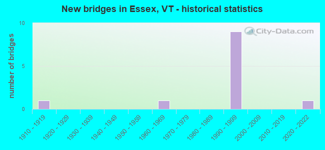
- New bridges - historical statistics
- 11910-1919
- 11960-1969
- 91990-1999
- 12020-2022


- Bridge Condition - Deck
- 57.1%Very good
- 42.9%Good

- Bridge Condition - Superstructure
- 85.7%Very good
- 14.3%Good

- Bridge Condition - Substructure
- 85.7%Good
- 14.3%Satisfactory

- Bridge Condition - Channel
- 60.0%Very good
- 40.0%Good
Find on map >> Show street view
Structure Number: 100406002004061, Location: 0.04 MI TO JCT W VT2A (Lat: 44.519581, Lng: -73.122425), Route carried "on" structure: Other road C3023, Year Built: 1910, Year Reconstructed: 1991, Status: Posted for load, Structure Length: 1.77m (5.81ft), Average Daily Traffic: 1,500 (year 2019), Truck Traffic: 2%, Average Future Daily Traffic: 1,575 (year 2029), Design Load: HS 20, Features Intersected: NEW ENGLAND CENTRAL RR
Minimum Vertical Clearance: 30+ m (98+ ft), Kilometerpoint: 0.000, Lanes on structure: 2, Owner: Town or Township Highway Agency, Approaching Roadway Width: 7.9m (25.9ft), Material/Design: Prestressed concrete, Design/Construction: Slab, Number Of Spans In Main Unit: 1, Length of Maximum Span: 15.8m (51.8ft), Curb-To-Curb Width: 5.7m (18.7ft), Out-to-Out Width: 6.1m (20.0ft)
Condition: Deck: Good, Superstructure: Good, Substructure: Satisfactory, Operating Rating: 61.7 metric tons, Method Used To Determine Operating Rating: Load Factor (LF), Inventory Rating: 36.3 metric tons, Method Used To Determine Inventory Rating: Load Factor (LF), Structural Evaluation: Equal to present minimum criteria, Deck Geometry: High priority of replacement, Underclear: Equal to present minimum criteria, Approach Roadway Alignment: High priority of corrective action, Length Of Structure Improvement: 1.77m (5.81ft), Designated Inspection Frequency: Every 24 months, Inspection Date: September 2021, Bridge Improvement Cost: $406,000, Roadway Improvement Cost: $50,000, Total Project Cost: $456,000 ( Estimate for 2020), Deck Structure Type: Concrete Precast Panels, Wearing Surface/Protective System: Wearing Surface: Bituminous, Membrane: Preformed Fabric
Find on map >> Show street view
Structure Number: 200030000504062, Location: 2.1 MI E JCT. VT.128 (Lat: 44.502158, Lng: -73.021383), Route carried "on" structure: State highway 15, Year Built: 1968, Status: Open, Structure Length: 2.41m (7.91ft), Average Daily Traffic: 10,100 (year 2018), Truck Traffic: 9%, Average Future Daily Traffic: 10,605 (year 2028), Design Load: HS 20, Features Intersected: BROWNS RIVER
Minimum Vertical Clearance: 30+ m (98+ ft), Kilometerpoint: 15.342, Lanes on structure: 2, Base Highway Network: Yes, Owner: State Highway Agency, Approaching Roadway Width: 10.7m (35.1ft), Skew: 1 degrees, Material/Design: Steel, Design/Construction: Stringer/Multi-beam, Number Of Spans In Main Unit: 1, Length of Maximum Span: 23.5m (77.1ft), Curb or Sidewalk Widths: Left: 0.5m (1.6ft), Right: 0.5m (1.6ft), Curb-To-Curb Width: 10.1m (33.1ft), Out-to-Out Width: 11.0m (36.1ft)
Condition: Deck: Good, Superstructure: Very good, Substructure: Good, Channel: Very good, Operating Rating: 88.9 metric tons, Method Used To Determine Operating Rating: Load Factor (LF), Inventory Rating: 52.6 metric tons, Method Used To Determine Inventory Rating: Load Factor (LF), Structural Evaluation: Better than present minimum criteria, Deck Geometry: Meets minimum limits, Waterway Adequacy: Better than present minimum criteria, Approach Roadway Alignment: Equal to present desirable criteria, Designated Inspection Frequency: Every 24 months, Inspection Date: May 2021, Deck Structure Type: Concrete Cast-file-Place, Wearing Surface/Protective System: Wearing Surface: Bituminous, Membrane: Preformed Fabric
Find on map >> Show street view
Structure Number: 200030002A04062, Location: 1.5 MI E JCT. VT. 2A (Lat: 44.507047, Lng: -73.088344), Route carried "on" structure: State highway 15, Year Built: 1993, Status: Open, Structure Length: 4.63m (15.19ft), Average Daily Traffic: 20,600 (year 2018), Truck Traffic: 10%, Average Future Daily Traffic: 21,630 (year 2028), Design Load: HS 25 or greater, Features Intersected: VT 15 OVER VT 289
Minimum Vertical Clearance: 30+ m (98+ ft), Kilometerpoint: 9.405, Lanes on structure: 2, Lanes under structure: 2, Base Highway Network: Yes, Owner: State Highway Agency, Approaching Roadway Width: 18.9m (62.0ft), Skew: 21 degrees, Material/Design: Steel, Design/Construction: Stringer/Multi-beam, Number Of Spans In Main Unit: 1, Length of Maximum Span: 44.5m (146.0ft), Curb or Sidewalk Widths: Left: 0.2m (0.7ft), Right: 2.0m (6.6ft), Curb-To-Curb Width: 18.7m (61.4ft), Out-to-Out Width: 21.7m (71.2ft)
Condition: Deck: Very good, Superstructure: Very good, Substructure: Good, Operating Rating: 89.8 metric tons, Method Used To Determine Operating Rating: Load Factor (LF), Inventory Rating: 82.6 metric tons, Method Used To Determine Inventory Rating: Load Factor (LF), Structural Evaluation: Better than present minimum criteria, Deck Geometry: Superior to present desirable criteria, Underclear: Equal to present minimum criteria, Approach Roadway Alignment: Equal to present desirable criteria, Designated Inspection Frequency: Every 24 months, Inspection Date: May 2021, Deck Structure Type: Concrete Cast-file-Place, Wearing Surface/Protective System: Wearing Surface: Bituminous, Membrane: Preformed Fabric, Deck Protection: Epoxy Coated Reinforcing
Find on map >> Show street view
Structure Number: 200033001304062, Location: 0.1 MI E JCT. VT. 2A (Lat: 44.518278, Lng: -73.121817), Route carried "on" structure: Ramp State highway 289, Year Built: 1993, Status: Open, Structure Length: 5.03m (16.50ft), Average Daily Traffic: 16,600 (year 2018), Truck Traffic: 10%, Average Future Daily Traffic: 17,430 (year 2028), Design Load: HS 25 or greater, Features Intersected: RAMP D OVER NEC RR
Minimum Vertical Clearance: 30+ m (98+ ft), Kilometerpoint: 12.598, Lanes on structure: 1, Base Highway Network: Yes, Owner: State Highway Agency, Approaching Roadway Width: 8.5m (27.9ft), Skew: 2 degrees, Material/Design: Steel continuous, Design/Construction: Stringer/Multi-beam, Number Of Spans In Main Unit: 2, Length of Maximum Span: 29.3m (96.1ft), Curb or Sidewalk Widths: Left: 0.2m (0.7ft), Right: 0.2m (0.7ft), Curb-To-Curb Width: 8.1m (26.6ft), Out-to-Out Width: 9.4m (30.8ft)
Condition: Deck: Very good, Superstructure: Very good, Substructure: Good, Operating Rating: 89.8 metric tons, Method Used To Determine Operating Rating: Load Factor (LF), Inventory Rating: 65.3 metric tons, Method Used To Determine Inventory Rating: Load Factor (LF), Structural Evaluation: Better than present minimum criteria, Deck Geometry: Superior to present desirable criteria, Underclear: Superior to present desirable criteria, Approach Roadway Alignment: Equal to present desirable criteria, Designated Inspection Frequency: Every 24 months, Inspection Date: May 2021, Deck Structure Type: Concrete Cast-file-Place, Wearing Surface/Protective System: Wearing Surface: Bituminous, Membrane: Preformed Fabric, Deck Protection: Epoxy Coated Reinforcing
Find on map >> Show street view
Structure Number: 200033001404062, Location: 0.1 MI E JCT. VT. 2A (Lat: 44.516589, Lng: -73.121042), Route carried "on" structure: Ramp State highway 289, Year Built: 1993, Status: Open, Structure Length: 10.21m (33.50ft), Average Daily Traffic: 16,600 (year 2018), Truck Traffic: 10%, Average Future Daily Traffic: 17,430 (year 2028), Design Load: HS 25 or greater, Features Intersected: RAMP A OVER NEC RR
Minimum Vertical Clearance: 30+ m (98+ ft), Kilometerpoint: 12.615, Lanes on structure: 1, Base Highway Network: Yes, Owner: State Highway Agency, Approaching Roadway Width: 8.5m (27.9ft), Skew: 4 degrees, Material/Design: Steel continuous, Design/Construction: Stringer/Multi-beam, Number Of Spans In Main Unit: 2, Length of Maximum Span: 52.7m (172.9ft), Curb or Sidewalk Widths: Left: 0.2m (0.7ft), Right: 0.2m (0.7ft), Curb-To-Curb Width: 8.1m (26.6ft), Out-to-Out Width: 9.4m (30.8ft)
Condition: Deck: Very good, Superstructure: Very good, Substructure: Good, Operating Rating: 89.8 metric tons, Method Used To Determine Operating Rating: Load Factor (LF), Inventory Rating: 62.6 metric tons, Method Used To Determine Inventory Rating: Load Factor (LF), Structural Evaluation: Better than present minimum criteria, Deck Geometry: Superior to present desirable criteria, Underclear: Superior to present desirable criteria, Approach Roadway Alignment: Equal to present desirable criteria, Designated Inspection Frequency: Every 24 months, Inspection Date: May 2021, Deck Structure Type: Concrete Cast-file-Place, Wearing Surface/Protective System: Wearing Surface: Bituminous, Membrane: Preformed Fabric, Deck Protection: Epoxy Coated Reinforcing
Find on map >> Show street view
Structure Number: 200033001704062, Location: 0.9 MI E VT 15 (Lat: 44.500781, Lng: -73.071808), Route carried "on" structure: Ramp State highway 289, Year Built: 1993, Status: Open, Structure Length: 0.76m (2.49ft), Average Daily Traffic: 2,800 (year 2018), Truck Traffic: 10%, Average Future Daily Traffic: 2,940 (year 2028), Design Load: HS 25 or greater, Features Intersected: ALDER BROOK
Minimum Vertical Clearance: 30+ m (98+ ft), Kilometerpoint: 16.814, Lanes on structure: 2, Base Highway Network: Yes, Owner: State Highway Agency, Approaching Roadway Width: 12.8m (42.0ft), Skew: 1 degrees, Material/Design: Concrete, Design/Construction: Culvert, Number Of Spans In Main Unit: 2, Length of Maximum Span: 3.0m (9.8ft)
Condition: Channel: Good, Culverts: Very good, Operating Rating: 68.0 metric tons, Method Used To Determine Operating Rating: Field evaluation and documented engineering judgment, Inventory Rating: 40.8 metric tons, Method Used To Determine Inventory Rating: Field evaluation and documented engineering judgment, Structural Evaluation: Equal to present desirable criteria, Waterway Adequacy: Superior to present desirable criteria, Approach Roadway Alignment: Equal to present desirable criteria, Designated Inspection Frequency: Every 24 months, Inspection Date: May 2021
Find on map >> Show street view
Structure Number: 200033001804062, Location: 2.0 MI E JCT VT 15 (Lat: 44.487742, Lng: -73.063722), Route carried "on" structure: Ramp State highway 289, Year Built: 1993, Status: Open, Structure Length: 0.94m (3.08ft), Average Daily Traffic: 5,400 (year 2018), Truck Traffic: 10%, Average Future Daily Traffic: 5,670 (year 2028), Design Load: HS 25 or greater, Features Intersected: ALDER BROOK
Minimum Vertical Clearance: 30+ m (98+ ft), Kilometerpoint: 18.450, Lanes on structure: 2, Base Highway Network: Yes, Owner: State Highway Agency, Approaching Roadway Width: 12.2m (40.0ft), Skew: 4 degrees, Material/Design: Concrete, Design/Construction: Culvert, Number Of Spans In Main Unit: 2, Length of Maximum Span: 5.2m (17.1ft)
Condition: Channel: Good, Culverts: Very good, Operating Rating: 68.0 metric tons, Method Used To Determine Operating Rating: Field evaluation and documented engineering judgment, Inventory Rating: 40.8 metric tons, Method Used To Determine Inventory Rating: Field evaluation and documented engineering judgment, Structural Evaluation: Equal to present desirable criteria, Waterway Adequacy: Superior to present desirable criteria, Approach Roadway Alignment: Equal to present desirable criteria, Designated Inspection Frequency: Every 24 months, Inspection Date: May 2021
Find on map >> Show street view
Structure Number: 2004060D1604061, Location: 0.6 MI S JCT. VT 15 (Lat: 44.504739, Lng: -73.079008), Route carried "on" structure: County highway TH95, Year Built: 1993, Status: Open, Structure Length: 4.51m (14.80ft), Average Daily Traffic: 670 (year 2019), Truck Traffic: 2%, Average Future Daily Traffic: 704 (year 2029), Design Load: HS 25 or greater, Features Intersected: TH 95 OVER VT 289, Facility Carried by Structure: TH 95 (ESSEX WAY)
Minimum Vertical Clearance: 30+ m (98+ ft), Kilometerpoint: 0.000, Lanes on structure: 2, Lanes under structure: 2, Owner: State Highway Agency, Approaching Roadway Width: 18.6m (61.0ft), Material/Design: Steel, Design/Construction: Stringer/Multi-beam, Number Of Spans In Main Unit: 1, Length of Maximum Span: 43.3m (142.1ft), Curb or Sidewalk Widths: Left: 0.2m (0.7ft), Right: 3.2m (10.5ft), Curb-To-Curb Width: 18.7m (61.4ft), Out-to-Out Width: 22.9m (75.1ft)
Condition: Deck: Very good, Superstructure: Very good, Substructure: Good, Operating Rating: 54.4 metric tons, Method Used To Determine Operating Rating: Allowable Stress (AS), Inventory Rating: 43.5 metric tons, Method Used To Determine Inventory Rating: Allowable Stress (AS), Structural Evaluation: Better than present minimum criteria, Deck Geometry: Superior to present desirable criteria, Underclear: Somewhat better than minimum adequacy, Approach Roadway Alignment: Equal to present desirable criteria, Designated Inspection Frequency: Every 24 months, Inspection Date: May 2021, Deck Structure Type: Concrete Cast-file-Place, Wearing Surface/Protective System: Wearing Surface: Bituminous, Membrane: Preformed Fabric, Deck Protection: Epoxy Coated Reinforcing
Find on map >> Show street view
Structure Number: 205400000204061, Location: 2.4 MI E JCT VT15&2A (Lat: 44.479944, Lng: -73.066644), Route carried "on" structure: State highway 117, Year Built: 2021, Status: Open, Structure Length: 1.04m (3.41ft), Average Daily Traffic: 9,400 (year 2015), Truck Traffic: 4%, Average Future Daily Traffic: 10,100 (year 2035), Design Load: HL 93, Features Intersected: ALDER BROOK
Minimum Vertical Clearance: 30+ m (98+ ft), Kilometerpoint: 3.887, Lanes on structure: 2, Base Highway Network: Yes, Owner: State Highway Agency, Approaching Roadway Width: 18.3m (60.0ft), Material/Design: Concrete, Design/Construction: Culvert, Number Of Spans In Main Unit: 1, Length of Maximum Span: 9.8m (32.2ft)
Condition: Channel: Very good, Culverts: Very good, Operating Rating: 59.0 metric tons, Method Used To Determine Operating Rating: Load and Resistance Factor (LRFR), Inventory Rating: 45.4 metric tons, Method Used To Determine Inventory Rating: Load and Resistance Factor (LRFR), Structural Evaluation: Equal to present desirable criteria, Waterway Adequacy: Equal to present desirable criteria, Approach Roadway Alignment: Equal to present desirable criteria, Designated Inspection Frequency: Every 24 months, Inspection Date: December 2021
Find on map >> Show street view
Structure Number: 205408000804062, Location: 0.34 MI TO JCT W VT117 (Lat: 44.471042, Lng: -73.043911), Route carried "on" structure: City street NWILR, Year Built: 1993, Status: Open, Structure Length: 8.60m (28.22ft), Average Daily Traffic: 5,400 (year 2016), Truck Traffic: 2%, Average Future Daily Traffic: 5,670 (year 2026), Design Load: HS 25 or greater, Features Intersected: WINOOSKI RIVER, Facility Carried by Structure: N. WILLISTON ROAD
Minimum Vertical Clearance: 30+ m (98+ ft), Kilometerpoint: 0.000, Lanes on structure: 2, Owner: Town or Township Highway Agency, Approaching Roadway Width: 9.8m (32.2ft), Skew: 3 degrees, Material/Design: Steel continuous, Design/Construction: Stringer/Multi-beam, Number Of Spans In Main Unit: 2, Length of Maximum Span: 42.1m (138.1ft), Curb or Sidewalk Widths: Left: 0.2m (0.7ft), Right: 0.2m (0.7ft), Curb-To-Curb Width: 9.3m (30.5ft), Out-to-Out Width: 10.5m (34.4ft)
Condition: Deck: Good, Superstructure: Very good, Substructure: Good, Channel: Very good, Operating Rating: 89.8 metric tons, Method Used To Determine Operating Rating: Load Factor (LF), Inventory Rating: 69.9 metric tons, Method Used To Determine Inventory Rating: Load Factor (LF), Structural Evaluation: Better than present minimum criteria, Deck Geometry: Meets minimum limits, Waterway Adequacy: Equal to present desirable criteria, Approach Roadway Alignment: Equal to present desirable criteria, Length Of Structure Improvement: 8.60m (28.22ft), Designated Inspection Frequency: Every 24 months, Underwater Inspection Frequency: Every 48 months, Inspection Date: July 2020, Underwater Inspection Date: August 2020, Bridge Improvement Cost: $3,415,000, Roadway Improvement Cost: $50,000, Total Project Cost: $3,465,000 ( Estimate for 2020), Deck Structure Type: Concrete Cast-file-Place, Wearing Surface/Protective System: Wearing Surface: Bituminous, Membrane: Preformed Fabric, Deck Protection: Epoxy Coated Reinforcing
Find on map >> Show street view
Structure Number: 200030002A04062, Location: 1.5 MI E JCT. VT. 2A (Lat: 44.507047, Lng: -73.088344), Route carried "under" structure: Ramp State highway 289, Year Built: 1993, Structure Length: 0. m, Average Daily Traffic: 9,150 (year 1998), Truck Traffic: 10%, Features Intersected: VT 15 OVER VT 289, Facility Carried by Structure: VT 00015 ML
Minimum Vertical Clearance: 5.23m (17.16ft), Kilometerpoint: 15.286, Lanes on structure: 2, Material/Design: Steel, Design/Construction: Stringer/Multi-beam, Length of Maximum Span: 44.5m (146.0ft)
Find on map >> Show street view
Structure Number: 2004060D1604061, Location: 0.6 MI S JCT. VT 15 (Lat: 44.504739, Lng: -73.079008), Route carried "under" structure: Ramp State highway 289, Year Built: 1993, Structure Length: 0. m, Average Daily Traffic: 3,130 (year 1997), Truck Traffic: 6%, Features Intersected: VT 289 UNDER TH 95, Facility Carried by Structure: TH 95 (ESSEX WAY)
Minimum Vertical Clearance: 4.90m (16.08ft), Kilometerpoint: 16.042, Lanes on structure: 2, Material/Design: Steel, Design/Construction: Stringer/Multi-beam, Length of Maximum Span: 43.3m (142.1ft)