Bridge Statistics for Exeter, Wisconsin (WI)
Condition, Traffic, Stress, Structural Evaluation, Project Costs
- National Bridge Inventory (NBI) Statistics
- 13Number of bridges
- 69ft / 21.2mTotal length
- $482,000Total costs
- 11,229Total average daily traffic
- 301Total average daily truck traffic
- 12,186Total future (year 2039) average daily traffic
- National Bridge Inventory (NBI) Registered Bridges for Exeter
- No street view available for this location
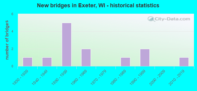
- New bridges - historical statistics
- 11930-1939
- 11940-1949
- 51950-1959
- 21960-1969
- 11980-1989
- 21990-1999
- 12010-2019

- Bridge Condition - Deck
- 10.0%Very good
- 30.0%Good
- 30.0%Satisfactory
- 10.0%Fair
- 10.0%Poor
- 10.0%Serious

- Bridge Condition - Superstructure
- 30.0%Very good
- 10.0%Good
- 30.0%Satisfactory
- 10.0%Fair
- 20.0%Poor

- Bridge Condition - Substructure
- 20.0%Very good
- 10.0%Good
- 30.0%Satisfactory
- 40.0%Fair

- Bridge Condition - Channel
- 30.8%Very good
- 23.1%Good
- 23.1%Satisfactory
- 15.4%Fair
- 7.7%Poor

- Bridge Condition - Culverts
- 66.7%Fair
- 33.3%Poor
Find on map >> Show street view
Structure Number: B23002, Location: 0.3M S JCT CTH KS (Lat: 42.566367, Lng: -89.575433), Route carried "on" structure: County highway , Year Built: 1958, Status: Open, Structure Length: 0.76m (2.49ft), Average Daily Traffic: 548 (year 2019), Average Future Daily Traffic: 602 (year 2039), Design Load: H 15, Features Intersected: BR RICHLAND CREEK, Facility Carried by Structure: CTH K
Minimum Vertical Clearance: 30+ m (98+ ft), Kilometerpoint: 0.000, Lanes on structure: 2, Owner: County Highway Agency, Approaching Roadway Width: 11.0m (36.1ft), Skew: 2 degrees, Material/Design: Concrete continuous, Design/Construction: Culvert, Number Of Spans In Main Unit: 2, Length of Maximum Span: 3.0m (9.8ft)
Condition: Channel: Good, Culverts: Fair, Operating Rating: 33.0 metric tons, Method Used To Determine Operating Rating: Field evaluation and documented engineering judgment, Inventory Rating: 19.4 metric tons, Method Used To Determine Inventory Rating: Field evaluation and documented engineering judgment, Structural Evaluation: Somewhat better than minimum adequacy, Waterway Adequacy: Equal to present desirable criteria, Approach Roadway Alignment: Equal to present desirable criteria, Designated Inspection Frequency: Every 24 months, Inspection Date: May 2020, Deck Structure Type: Concrete Cast-file-Place, Wearing Surface/Protective System: Wearing Surface: Bituminous
Find on map >> Show street view
Structure Number: B230021, Location: 1.2M E JCT STH 69 TO N (Lat: 42.848714, Lng: -89.524481), Route carried "on" structure: State highway 92, Year Built: 1959, Status: Open, Structure Length: 0.84m (2.76ft), Average Daily Traffic: 2,300 (year 2019), Truck Traffic: 4%, Average Future Daily Traffic: 2,130 (year 2040), Design Load: H 20, Features Intersected: ROSS CROSSING CREEK
Minimum Vertical Clearance: 30+ m (98+ ft), Kilometerpoint: 0.000, Lanes on structure: 2, Owner: State Highway Agency, Approaching Roadway Width: 11.6m (38.1ft), Skew: 1 degrees, Material/Design: Concrete, Design/Construction: Slab, Number Of Spans In Main Unit: 1, Length of Maximum Span: 8.0m (26.2ft), Curb-To-Curb Width: 10.4m (34.1ft), Out-to-Out Width: 11.1m (36.4ft)
Condition: Deck: Satisfactory, Superstructure: Satisfactory, Substructure: Fair, Channel: Good, Operating Rating: 45.7 metric tons, Method Used To Determine Operating Rating: Load Factor (LF), Inventory Rating: 27.5 metric tons, Method Used To Determine Inventory Rating: Load Factor (LF), Structural Evaluation: Somewhat better than minimum adequacy, Deck Geometry: Somewhat better than minimum adequacy, Waterway Adequacy: Equal to present desirable criteria, Approach Roadway Alignment: Equal to present desirable criteria, Designated Inspection Frequency: Every 24 months, Inspection Date: Febuary 2021, Deck Structure Type: Concrete Cast-file-Place, Wearing Surface/Protective System: Wearing Surface: Low Slump Concrete
Find on map >> Show street view
Structure Number: B230022, Location: 0.4M E JCT CTH X (Lat: 42.827872, Lng: -89.487672), Route carried "on" structure: State highway 92, Year Built: 1959, Status: Open, Structure Length: 0.81m (2.66ft), Average Daily Traffic: 1,400 (year 2019), Truck Traffic: 5%, Average Future Daily Traffic: 1,380 (year 2039), Design Load: H 20, Features Intersected: STORY CREEK
Minimum Vertical Clearance: 30+ m (98+ ft), Kilometerpoint: 0.000, Lanes on structure: 2, Owner: State Highway Agency, Approaching Roadway Width: 11.6m (38.1ft), Material/Design: Concrete, Design/Construction: Slab, Number Of Spans In Main Unit: 1, Length of Maximum Span: 7.4m (24.3ft), Curb-To-Curb Width: 10.4m (34.1ft), Out-to-Out Width: 11.1m (36.4ft)
Condition: Deck: Satisfactory, Superstructure: Satisfactory, Substructure: Fair, Channel: Poor, Operating Rating: 37.6 metric tons, Method Used To Determine Operating Rating: Load Factor (LF), Inventory Rating: 22.7 metric tons, Method Used To Determine Inventory Rating: Load Factor (LF), Structural Evaluation: Somewhat better than minimum adequacy, Deck Geometry: Equal to present minimum criteria, Waterway Adequacy: Equal to present desirable criteria, Approach Roadway Alignment: Equal to present desirable criteria, Designated Inspection Frequency: Every 24 months, Inspection Date: August 2020, Deck Structure Type: Concrete Cast-file-Place, Wearing Surface/Protective System: Wearing Surface: Low Slump Concrete
Find on map >> Show street view
Structure Number: B230044, Location: 0.1M E JCT CTH D TO S (Lat: 42.827147, Lng: -89.509917), Route carried "on" structure: State highway 92, Year Built: 1982, Status: Open, Structure Length: 5.10m (16.73ft), Average Daily Traffic: 2,100 (year 2019), Truck Traffic: 4%, Average Future Daily Traffic: 2,710 (year 2039), Design Load: HS 20, Features Intersected: SUGAR RIVER
Minimum Vertical Clearance: 30+ m (98+ ft), Kilometerpoint: 0.000, Lanes on structure: 2, Owner: State Highway Agency, Approaching Roadway Width: 10.4m (34.1ft), Skew: 1 degrees, Material/Design: Prestressed concrete continuous, Design/Construction: Stringer/Multi-beam, Number Of Spans In Main Unit: 3, Length of Maximum Span: 16.9m (55.4ft), Curb-To-Curb Width: 10.4m (34.1ft), Out-to-Out Width: 11.3m (37.1ft)
Condition: Deck: Good, Superstructure: Very good, Substructure: Satisfactory, Channel: Satisfactory, Operating Rating: 63.7 metric tons, Method Used To Determine Operating Rating: Load Factor (LF), Inventory Rating: 37.3 metric tons, Method Used To Determine Inventory Rating: Load Factor (LF), Structural Evaluation: Equal to present minimum criteria, Deck Geometry: Somewhat better than minimum adequacy, Waterway Adequacy: Superior to present desirable criteria, Approach Roadway Alignment: Equal to present desirable criteria, Designated Inspection Frequency: Every 24 months, Underwater Inspection Frequency: Every 60 months, Inspection Date: August 2020, Underwater Inspection Date: October 2018, Deck Structure Type: Concrete Cast-file-Place, Wearing Surface/Protective System: Wearing Surface: Monolithic Concrete
Find on map >> Show street view
Structure Number: B230081, Location: 1.9M W JCT CTH CC (Lat: 42.786383, Lng: -89.588783), Route carried "on" structure: City street , Year Built: 1990, Status: Open, Structure Length: 1.37m (4.49ft), Average Daily Traffic: 158 (year 2019), Truck Traffic: 9%, Average Future Daily Traffic: 173 (year 2039), Design Load: HS 20, Features Intersected: LITTLE SUGAR RIVER, Facility Carried by Structure: LRD EXETER CROSSIN
Minimum Vertical Clearance: 30+ m (98+ ft), Kilometerpoint: 0.000, Lanes on structure: 2, Owner: Town or Township Highway Agency, Approaching Roadway Width: 7.9m (25.9ft), Material/Design: Concrete, Design/Construction: Slab, Number Of Spans In Main Unit: 1, Length of Maximum Span: 13.1m (43.0ft), Curb-To-Curb Width: 7.3m (24.0ft), Out-to-Out Width: 7.9m (25.9ft)
Condition: Deck: Good, Superstructure: Good, Substructure: Very good, Channel: Very good, Operating Rating: 63.7 metric tons, Method Used To Determine Operating Rating: Load Factor (LF), Inventory Rating: 37.3 metric tons, Method Used To Determine Inventory Rating: Load Factor (LF), Structural Evaluation: Better than present minimum criteria, Deck Geometry: Somewhat better than minimum adequacy, Waterway Adequacy: Equal to present desirable criteria, Approach Roadway Alignment: Equal to present desirable criteria, Designated Inspection Frequency: Every 48 months, Inspection Date: April 2020, Deck Structure Type: Concrete Cast-file-Place, Wearing Surface/Protective System: Wearing Surface: Monolithic Concrete, Deck Protection: Epoxy Coated Reinforcing
Find on map >> Show street view
Structure Number: B230091, Location: 1.0M S JCT STH 92 (Lat: 42.813617, Lng: -89.496450), Route carried "on" structure: County highway , Year Built: 1993, Status: Open, Structure Length: 1.85m (6.07ft), Average Daily Traffic: 189 (year 2019), Truck Traffic: 8%, Average Future Daily Traffic: 207 (year 2039), Design Load: HS 20, Features Intersected: STORY CREEK, Facility Carried by Structure: CTH X
Minimum Vertical Clearance: 30+ m (98+ ft), Kilometerpoint: 0.000, Lanes on structure: 2, Owner: County Highway Agency, Approaching Roadway Width: 7.9m (25.9ft), Material/Design: Prestressed concrete, Design/Construction: Stringer/Multi-beam, Number Of Spans In Main Unit: 1, Length of Maximum Span: 18.0m (59.1ft), Curb-To-Curb Width: 7.9m (25.9ft), Out-to-Out Width: 8.5m (27.9ft)
Condition: Deck: Good, Superstructure: Very good, Substructure: Good, Channel: Very good, Operating Rating: 60.4 metric tons, Method Used To Determine Operating Rating: Load Factor (LF), Inventory Rating: 35.6 metric tons, Method Used To Determine Inventory Rating: Load Factor (LF), Structural Evaluation: Better than present minimum criteria, Deck Geometry: Somewhat better than minimum adequacy, Waterway Adequacy: Equal to present desirable criteria, Approach Roadway Alignment: Equal to present desirable criteria, Designated Inspection Frequency: Every 48 months, Inspection Date: April 2020, Deck Structure Type: Concrete Cast-file-Place, Wearing Surface/Protective System: Wearing Surface: Monolithic Concrete, Deck Protection: Epoxy Coated Reinforcing
Find on map >> Show street view
Structure Number: B230163, Location: 2.3M N JCT CTH C (Lat: 42.795200, Lng: -89.516233), Route carried "on" structure: County highway , Year Built: 2011, Status: Open, Structure Length: 0.93m (3.05ft), Average Daily Traffic: 652 (year 2019), Truck Traffic: 4%, Average Future Daily Traffic: 717 (year 2039), Design Load: HL 93, Features Intersected: BR SUGAR RIVER, Facility Carried by Structure: CTH D
Minimum Vertical Clearance: 30+ m (98+ ft), Kilometerpoint: 0.000, Lanes on structure: 2, Owner: County Highway Agency, Approaching Roadway Width: 10.4m (34.1ft), Material/Design: Concrete, Design/Construction: Slab, Number Of Spans In Main Unit: 1, Length of Maximum Span: 8.5m (27.9ft), Curb-To-Curb Width: 9.1m (29.9ft), Out-to-Out Width: 9.9m (32.5ft)
Condition: Deck: Very good, Superstructure: Very good, Substructure: Very good, Channel: Very good, Operating Rating: 43.7 metric tons, Method Used To Determine Operating Rating: Load and Resistance Factor Rating (LRFR) rating reported by rating factor(RF) method using HL-93 loadings, Inventory Rating: 33.7 metric tons, Method Used To Determine Inventory Rating: Load and Resistance Factor Rating (LRFR) rating reported by rating factor(RF) method using HL-93 loadings, Structural Evaluation: Equal to present desirable criteria, Deck Geometry: Equal to present minimum criteria, Waterway Adequacy: Equal to present desirable criteria, Approach Roadway Alignment: Equal to present desirable criteria, Designated Inspection Frequency: Every 48 months, Inspection Date: April 2020, Deck Structure Type: Concrete Cast-file-Place, Wearing Surface/Protective System: Wearing Surface: Monolithic Concrete, Deck Protection: Epoxy Coated Reinforcing
Find on map >> Show street view
Structure Number: P23091, Location: 2.2M N JCT STH 11 (Lat: 42.654581, Lng: -89.387033), Route carried "on" structure: County highway , Year Built: 1940, Status: Open, Structure Length: 0.85m (2.79ft), Average Daily Traffic: 699 (year 2019), Average Future Daily Traffic: 768 (year 2040), Design Load: HS 20, Features Intersected: BR NORWEGIAN CREEK, Facility Carried by Structure: CTH E
Minimum Vertical Clearance: 30+ m (98+ ft), Kilometerpoint: 0.000, Lanes on structure: 2, Owner: County Highway Agency, Approaching Roadway Width: 8.5m (27.9ft), Skew: 3 degrees, Material/Design: Concrete continuous, Design/Construction: Culvert, Number Of Spans In Main Unit: 2, Length of Maximum Span: 4.1m (13.5ft), Curb-To-Curb Width: 7.8m (25.6ft), Out-to-Out Width: 10.7m (35.1ft)
Condition: Channel: Fair, Culverts: Poor, Operating Rating: 33.0 metric tons, Method Used To Determine Operating Rating: Field evaluation and documented engineering judgment, Inventory Rating: 19.4 metric tons, Method Used To Determine Inventory Rating: Field evaluation and documented engineering judgment, Structural Evaluation: Meets minimum limits, Deck Geometry: Meets minimum limits, Waterway Adequacy: Equal to present desirable criteria, Approach Roadway Alignment: Equal to present desirable criteria, Length Of Structure Improvement: 1.31m (4.30ft), Designated Inspection Frequency: Every 12 months, Inspection Date: April 2021, Bridge Improvement Cost: $123,000, Roadway Improvement Cost: $12,000, Total Project Cost: $185,000 ( Estimate for 2021), Deck Structure Type: Concrete Cast-file-Place, Wearing Surface/Protective System: Wearing Surface: Bituminous
Find on map >> Show street view
Structure Number: P230911, Location: 2.3M E JCT STH 69 (Lat: 42.806153, Lng: -89.601050), Route carried "on" structure: City street , Year Built: 1930, Status: Open, Structure Length: 0.75m (2.46ft), Average Daily Traffic: 105 (year 2019), Average Future Daily Traffic: 115 (year 2040), Design Load: H 15, Features Intersected: LITTLE SUGAR RIVER, Facility Carried by Structure: LRD AIRPORT RD
Minimum Vertical Clearance: 30+ m (98+ ft), Kilometerpoint: 0.000, Lanes on structure: 2, Owner: Town or Township Highway Agency, Approaching Roadway Width: 6.7m (22.0ft), Material/Design: Steel, Design/Construction: Stringer/Multi-beam, Number Of Spans In Main Unit: 1, Length of Maximum Span: 7.0m (23.0ft), Curb-To-Curb Width: 7.0m (23.0ft), Out-to-Out Width: 7.3m (24.0ft)
Condition: Deck: Serious, Superstructure: Poor, Substructure: Fair, Channel: Fair, Operating Rating: 37.6 metric tons, Method Used To Determine Operating Rating: Load Factor (LF), Inventory Rating: 22.7 metric tons, Method Used To Determine Inventory Rating: Load Factor (LF), Structural Evaluation: Meets minimum limits, Deck Geometry: Meets minimum limits, Waterway Adequacy: Equal to present desirable criteria, Approach Roadway Alignment: Equal to present minimum criteria, Length Of Structure Improvement: 1.19m (3.90ft), Designated Inspection Frequency: Every 12 months, Inspection Date: April 2021, Bridge Improvement Cost: $92,000, Roadway Improvement Cost: $9,000, Total Project Cost: $138,000 ( Estimate for 2021), Deck Structure Type: Concrete Cast-file-Place, Wearing Surface/Protective System: Wearing Surface: Bituminous
Find on map >> Show street view
Structure Number: P230916, Location: 1.3M S JCT STH 92 (Lat: 42.808050, Lng: -89.521117), Route carried "on" structure: County highway , Year Built: 1950, Status: Open, Structure Length: 0.69m (2.26ft), Average Daily Traffic: 590 (year 2019), Average Future Daily Traffic: 649 (year 2039), Design Load: H 15, Features Intersected: BR SUGAR RIVER, Facility Carried by Structure: CTH D
Minimum Vertical Clearance: 30+ m (98+ ft), Kilometerpoint: 0.000, Lanes on structure: 2, Owner: County Highway Agency, Approaching Roadway Width: 9.8m (32.2ft), Material/Design: Concrete continuous, Design/Construction: Culvert, Number Of Spans In Main Unit: 2, Length of Maximum Span: 3.1m (10.2ft), Curb-To-Curb Width: 7.9m (25.9ft), Out-to-Out Width: 8.5m (27.9ft)
Condition: Channel: Satisfactory, Culverts: Fair, Operating Rating: 53.9 metric tons, Method Used To Determine Operating Rating: Field evaluation and documented engineering judgment, Inventory Rating: 24.3 metric tons, Method Used To Determine Inventory Rating: Field evaluation and documented engineering judgment, Structural Evaluation: Somewhat better than minimum adequacy, Deck Geometry: Somewhat better than minimum adequacy, Waterway Adequacy: Equal to present desirable criteria, Approach Roadway Alignment: Equal to present desirable criteria, Designated Inspection Frequency: Every 24 months, Inspection Date: April 2020, Deck Structure Type: Concrete Cast-file-Place, Wearing Surface/Protective System: Wearing Surface: Bituminous
Find on map >> Show street view
Structure Number: P23096, Location: 0.6M N JCT CTH B (Lat: 42.558383, Lng: -89.794183), Route carried "on" structure: County highway , Year Built: 1961, Status: Open, Structure Length: 0.67m (2.20ft), Average Daily Traffic: 717 (year 2019), Average Future Daily Traffic: 788 (year 2040), Design Load: HS 20, Features Intersected: BR PECATONICA RIVER, Facility Carried by Structure: CTH M
Minimum Vertical Clearance: 30+ m (98+ ft), Kilometerpoint: 0.000, Lanes on structure: 2, Owner: County Highway Agency, Approaching Roadway Width: 12.8m (42.0ft), Material/Design: Concrete, Design/Construction: Slab, Number Of Spans In Main Unit: 1, Length of Maximum Span: 6.4m (21.0ft), Curb-To-Curb Width: 9.4m (30.8ft), Out-to-Out Width: 9.8m (32.2ft)
Condition: Deck: Poor, Superstructure: Poor, Substructure: Satisfactory, Channel: Good, Operating Rating: 34.3 metric tons, Method Used To Determine Operating Rating: Load Factor (LF), Inventory Rating: 21.1 metric tons, Method Used To Determine Inventory Rating: Load Factor (LF), Structural Evaluation: Meets minimum limits, Deck Geometry: Equal to present minimum criteria, Waterway Adequacy: Equal to present desirable criteria, Approach Roadway Alignment: Equal to present desirable criteria, Length Of Structure Improvement: 1.13m (3.71ft), Designated Inspection Frequency: Every 12 months, Inspection Date: May 2021, Bridge Improvement Cost: $106,000, Roadway Improvement Cost: $10,000, Total Project Cost: $159,000 ( Estimate for 2021), Deck Structure Type: Concrete Cast-file-Place, Wearing Surface/Protective System: Wearing Surface: Bituminous
Find on map >> Show street view
Structure Number: P230966, Location: 0.4M N JCT CTH W (Lat: 42.835217, Lng: -89.549017), Route carried "on" structure: County highway , Year Built: 1957, Status: Open, Structure Length: 0.93m (3.05ft), Average Daily Traffic: 1,582 (year 2019), Average Future Daily Traffic: 1,740 (year 2039), Design Load: H 15, Features Intersected: BR ROSS CROSSING CREEK, Facility Carried by Structure: CTH CC
Minimum Vertical Clearance: 30+ m (98+ ft), Kilometerpoint: 0.000, Lanes on structure: 2, Owner: County Highway Agency, Approaching Roadway Width: 9.1m (29.9ft), Skew: 1 degrees, Material/Design: Steel, Design/Construction: Stringer/Multi-beam, Number Of Spans In Main Unit: 1, Length of Maximum Span: 8.8m (28.9ft), Curb-To-Curb Width: 8.4m (27.6ft), Out-to-Out Width: 8.5m (27.9ft)
Condition: Deck: Fair, Superstructure: Fair, Substructure: Fair, Channel: Satisfactory, Operating Rating: 45.7 metric tons, Method Used To Determine Operating Rating: Load Factor (LF), Inventory Rating: 27.5 metric tons, Method Used To Determine Inventory Rating: Load Factor (LF), Structural Evaluation: Somewhat better than minimum adequacy, Deck Geometry: Meets minimum limits, Waterway Adequacy: Equal to present desirable criteria, Approach Roadway Alignment: Equal to present desirable criteria, Designated Inspection Frequency: Every 24 months, Inspection Date: April 2020, Deck Structure Type: Concrete Cast-file-Place, Wearing Surface/Protective System: Wearing Surface: Bituminous
Find on map >> Show street view
Structure Number: P230969, Location: 2.3M N JCT CTH C (Lat: 42.799500, Lng: -89.486817), Route carried "on" structure: County highway , Year Built: 1969, Status: Open, Structure Length: 5.64m (18.50ft), Average Daily Traffic: 189 (year 2019), Average Future Daily Traffic: 207 (year 2039), Design Load: H 20, Features Intersected: SUGAR RIVER, Facility Carried by Structure: CTH X
Minimum Vertical Clearance: 30+ m (98+ ft), Kilometerpoint: 0.000, Lanes on structure: 2, Owner: County Highway Agency, Approaching Roadway Width: 8.5m (27.9ft), Material/Design: Prestressed concrete, Design/Construction: Stringer/Multi-beam, Number Of Spans In Main Unit: 3, Length of Maximum Span: 18.7m (61.4ft), Curb-To-Curb Width: 9.1m (29.9ft), Out-to-Out Width: 9.9m (32.5ft)
Condition: Deck: Satisfactory, Superstructure: Satisfactory, Substructure: Satisfactory, Channel: Very good, Operating Rating: 49.0 metric tons, Method Used To Determine Operating Rating: Load Factor (LF), Inventory Rating: 17.8 metric tons, Method Used To Determine Inventory Rating: Load Factor (LF), Structural Evaluation: Somewhat better than minimum adequacy, Deck Geometry: Equal to present minimum criteria, Waterway Adequacy: Equal to present desirable criteria, Approach Roadway Alignment: Equal to present desirable criteria, Designated Inspection Frequency: Every 24 months, Inspection Date: April 2020, Deck Structure Type: Concrete Cast-file-Place, Wearing Surface/Protective System: Wearing Surface: Bituminous